
2024 ENSO Updates
Moderator: S2k Moderators
Forum rules

The posts in this forum are NOT official forecasts and should not be used as such. They are just the opinion of the poster and may or may not be backed by sound meteorological data. They are NOT endorsed by any professional institution or STORM2K. For official information, please refer to products from the National Hurricane Center and National Weather Service.
-
cycloneye

- Admin

- Posts: 149260
- Age: 69
- Joined: Thu Oct 10, 2002 10:54 am
- Location: San Juan, Puerto Rico
Re: 2024 ENSO Updates: CPC August update= Neutral next few months / 66% of La Niña Sept thru Nov
0 likes
Visit the Caribbean-Central America Weather Thread where you can find at first post web cams,radars
and observations from Caribbean basin members Click Here
and observations from Caribbean basin members Click Here
-
Kingarabian

- S2K Supporter

- Posts: 16345
- Joined: Sat Aug 08, 2009 3:06 am
- Location: Honolulu, Hawaii
Re: 2024 ENSO Updates: CPC August update= Neutral next few months / 66% of La Niña Sept thru Nov
cycloneye wrote:https://www.cpc.ncep.noaa.gov/products/analysis_monitoring/enso_advisory/ensodisc.shtml
https://i.imgur.com/TyH7GTp.png
Inline with the discussions on here since the start of the season.
0 likes
RIP Kobe Bryant

Re: 2024 ENSO Updates: CPC August update= Neutral next few months / 66% of La Niña Sept thru Nov
Kingarabian wrote:cycloneye wrote:https://www.cpc.ncep.noaa.gov/products/analysis_monitoring/enso_advisory/ensodisc.shtml
https://i.imgur.com/TyH7GTp.png
Inline with the discussions on here since the start of the season.
I'd say that's pretty true. I'm pretty sure that if one were to go back to perhaps February or March however, the expectations were for Nina conditions to begin a bit earlier in the season. Given what I have noticed to be a downstream lag for newly developed ENSO phases over the years, it is my sense that NINA impact to this Atlantic season would then lag roughly 2-4 weeks? If so, further enhanced conditions in the Atlantic may not be realized until perhaps early to mid-September. From that alone, I am anticipating a particularly harsh and active September & October (and a continued November threat to Central America and Mexico).
What I am more curious about is whether or not (or to what extent) the overall longwave pattern might change in response to NINA conditions or other seasonal variations. We already know that overall instability should aid in an increase of tropical activity but I'm more concerned about nuances that may impact changes in the mid-level ridging pattern or affect the Zonal Westerlies flow perhaps causing a higher latitude progressive zonal flow and a decrease in mid latitude trough incursions during this period. Basically, those atmospheric "missile guidance systems"
3 likes
Andy D
(For official information, please refer to the NHC and NWS products.)
(For official information, please refer to the NHC and NWS products.)


Re: 2024 ENSO Updates: CPC August update= Cold Neutral next few months / 66% of La Niña Sept thru Nov
SOI is very low for a La Nina...
3 likes
The above post and any post by Ntxw is NOT an official forecast and should not be used as such. It is just the opinion of the poster and may or may not be backed by sound meteorological data. It is NOT endorsed by any professional institution including Storm2k. For official information, please refer to NWS products.
Help support Storm2K!
-
Kingarabian
- S2K Supporter
- Posts: 16345
- Joined: Sat Aug 08, 2009 3:06 am
- Location: Honolulu, Hawaii
Re: 2024 ENSO Updates: CPC August update= Neutral next few months / 66% of La Niña Sept thru Nov
chaser1 wrote:Kingarabian wrote:cycloneye wrote:https://www.cpc.ncep.noaa.gov/products/analysis_monitoring/enso_advisory/ensodisc.shtml
https://i.imgur.com/TyH7GTp.png
Inline with the discussions on here since the start of the season.
I'd say that's pretty true. I'm pretty sure that if one were to go back to perhaps February or March however, the expectations were for Nina conditions to begin a bit earlier in the season. Given what I have noticed to be a downstream lag for newly developed ENSO phases over the years, it is my sense that NINA impact to this Atlantic season would then lag roughly 2-4 weeks? If so, further enhanced conditions in the Atlantic may not be realized until perhaps early to mid-September. From that alone, I am anticipating a particularly harsh and active September & October (and a continued November threat to Central America and Mexico).
What I am more curious about is whether or not (or to what extent) the overall longwave pattern might change in response to NINA conditions or other seasonal variations. We already know that overall instability should aid in an increase of tropical activity but I'm more concerned about nuances that may impact changes in the mid-level ridging pattern or affect the Zonal Westerlies flow perhaps causing a higher latitude progressive zonal flow and a decrease in mid latitude trough incursions during this period. Basically, those atmospheric "missile guidance systems"which will ultimately affect storm track patterns.
Some of the most memorable Atlantic hurricane seasons occurred when ENSO was cool neutral and transitioning to La Nina late in the season. So IMO, it doesn't get much better than this for an active and memorable season. The only wrinkle is the SOI being in El Nino territory. Meaning that the atmosphere is not yet coupled with the ocean so it may effect somethings downstream.
2 likes
RIP Kobe Bryant
Re: 2024 ENSO Updates
Finally getting some decent +SOI. Perhaps more Nina like-late summer pattern may appear. More favorable for Atlantic activity.
Interestingly relative to normal anoms, 2024 around this time is cooling tropics (not unexpected during Nina for the Pacific) but compared to the high lats the Atlantic and Indian Oceans as well.
Interestingly relative to normal anoms, 2024 around this time is cooling tropics (not unexpected during Nina for the Pacific) but compared to the high lats the Atlantic and Indian Oceans as well.
3 likes
The above post and any post by Ntxw is NOT an official forecast and should not be used as such. It is just the opinion of the poster and may or may not be backed by sound meteorological data. It is NOT endorsed by any professional institution including Storm2k. For official information, please refer to NWS products.
Help support Storm2K!
Help support Storm2K!
Re: 2024 ENSO Updates
The Nina transition has occurred much slower than most of us anticipated earlier in the year. The top layer near the surface has held on to warmth (surprised?) longer than you'd typically see in a quick Nina development. The global oceans are warm, and have continued to warm in particular the mid-high latitudes. Our canonical thinking of ENSO likely will have to change. As waters warm in the extra-tropical regions they will inevitably play an ever growing role as the thresholds for sustaining convection moves northward.

1 likes
The above post and any post by Ntxw is NOT an official forecast and should not be used as such. It is just the opinion of the poster and may or may not be backed by sound meteorological data. It is NOT endorsed by any professional institution including Storm2k. For official information, please refer to NWS products.
Help support Storm2K!
Help support Storm2K!
-
Kingarabian
- S2K Supporter
- Posts: 16345
- Joined: Sat Aug 08, 2009 3:06 am
- Location: Honolulu, Hawaii
Re: 2024 ENSO Updates
30 day SOI flipped positive finally. Atlantic should respond in during the first half of September.
2 likes
RIP Kobe Bryant
-
cycloneye
- Admin
- Posts: 149260
- Age: 69
- Joined: Thu Oct 10, 2002 10:54 am
- Location: San Juan, Puerto Rico
Re: 2024 ENSO Updates: CPC weekly update of 8/26/24=Niño 3.4 at 0.0C
CPC in the weekly update has niño 3.4 at 0.0C.
LarryWx, how does the RONI have it?

https://www.cpc.ncep.noaa.gov/products/ ... ts-web.pdf
LarryWx, how does the RONI have it?
https://www.cpc.ncep.noaa.gov/products/ ... ts-web.pdf
2 likes
Visit the Caribbean-Central America Weather Thread where you can find at first post web cams,radars
and observations from Caribbean basin members Click Here
and observations from Caribbean basin members Click Here
Re: 2024 ENSO Updates: CPC weekly update of 8/26/24=Niño 3.4 at 0.0C
cycloneye wrote:CPC in the weekly update has niño 3.4 at 0.0C.
LarryWx, how does the RONI have it?
https://i.imgur.com/227RemN.jpeg
https://www.cpc.ncep.noaa.gov/products/ ... ts-web.pdf
Estimated RONI is .-0.6ish, a fairly dangerous level for the corridor from the Lesser Antilles NW to the E GOM including the SE US (not what I want to see but that’s just a general indicator as analogs vary quite a bit).
1 likes
Personal Forecast Disclaimer:
The posts in this forum are NOT official forecasts and should not be used as such. They are just the opinion of the poster and may or may not be backed by sound meteorological data. They are NOT endorsed by any professional institution or storm2k.org. For official information, please refer to the NHC and NWS products.
The posts in this forum are NOT official forecasts and should not be used as such. They are just the opinion of the poster and may or may not be backed by sound meteorological data. They are NOT endorsed by any professional institution or storm2k.org. For official information, please refer to the NHC and NWS products.
-
Kingarabian
- S2K Supporter
- Posts: 16345
- Joined: Sat Aug 08, 2009 3:06 am
- Location: Honolulu, Hawaii
Re: 2024 ENSO Updates: CPC weekly update of 8/26/24=Niño 3.4 at 0.0C
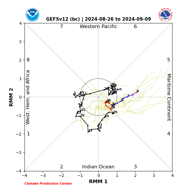
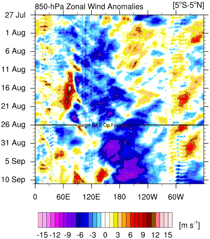
Although it might be late in the game, the GFS has the MJO going strong over the MC. As a result it shows a very significant dateline trade burst.
3 likes
RIP Kobe Bryant
-
cycloneye
- Admin
- Posts: 149260
- Age: 69
- Joined: Thu Oct 10, 2002 10:54 am
- Location: San Juan, Puerto Rico
Re: 2024 ENSO Updates: CPC weekly update= Niño 3.4 down to -0.2C
The weekly CPC update has niño 3.4 going down to -0.2C and niño 3 down to -0.5C.

https://www.cpc.ncep.noaa.gov/products/ ... ts-web.pdf
https://www.cpc.ncep.noaa.gov/products/ ... ts-web.pdf
1 likes
Visit the Caribbean-Central America Weather Thread where you can find at first post web cams,radars
and observations from Caribbean basin members Click Here
and observations from Caribbean basin members Click Here
Re: 2024 ENSO Updates: CPC weekly update= Niño 3.4 down to -0.2C
Really late to only be getting -0.2C. Weak Nina may be the ceiling now.
Other note, the global TC ACE continues to be below normal. Seems to be plaguing all basins (though the Atlantic had a hot start.) While I wouldn't consider 2013 an analog, I would definitely revisit the circumstances that caused the global slowing of tropical activity as well as the weaker -ENSO. All this in a similar -PDO mode that killed the 2012 El Nino potential. 2023 did have an El Nino but not completely all of the typical El Nino behaviors.
Other note, the global TC ACE continues to be below normal. Seems to be plaguing all basins (though the Atlantic had a hot start.) While I wouldn't consider 2013 an analog, I would definitely revisit the circumstances that caused the global slowing of tropical activity as well as the weaker -ENSO. All this in a similar -PDO mode that killed the 2012 El Nino potential. 2023 did have an El Nino but not completely all of the typical El Nino behaviors.
2 likes
The above post and any post by Ntxw is NOT an official forecast and should not be used as such. It is just the opinion of the poster and may or may not be backed by sound meteorological data. It is NOT endorsed by any professional institution including Storm2k. For official information, please refer to NWS products.
Help support Storm2K!
Help support Storm2K!
-
SconnieCane
- Category 5

- Posts: 1013
- Joined: Thu Aug 02, 2018 5:29 pm
- Location: Madison, WI
Re: 2024 ENSO Updates: CPC weekly update= Niño 3.4 down to -0.2C
Ntxw wrote:Really late to only be getting -0.2C. Weak Nina may be the ceiling now.
Other note, the global TC ACE continues to be below normal. Seems to be plaguing all basins (though the Atlantic had a hot start.) While I wouldn't consider 2013 an analog, I would definitely revisit the circumstances that caused the global slowing of tropical activity as well as the weaker -ENSO. All this in a similar -PDO mode that killed the 2012 El Nino potential. 2023 did have an El Nino but not completely all of the typical El Nino behaviors.
I thought 2011-12 featured a powerful La Nina which was correlated with the extremely violent tornado activity of spring 2011 and the exceptionally warm/snowless winter which led to the anomalously warm early spring and scorching summer of 2012. However apart from featuring Irene and Sandy, I don't recall anything exceptional about those two hurricane seasons.
0 likes
-
Kingarabian
- S2K Supporter
- Posts: 16345
- Joined: Sat Aug 08, 2009 3:06 am
- Location: Honolulu, Hawaii
Re: 2024 ENSO Updates: CPC weekly update= Niño 3.4 down to -0.2C
SconnieCane wrote:Ntxw wrote:Really late to only be getting -0.2C. Weak Nina may be the ceiling now.
Other note, the global TC ACE continues to be below normal. Seems to be plaguing all basins (though the Atlantic had a hot start.) While I wouldn't consider 2013 an analog, I would definitely revisit the circumstances that caused the global slowing of tropical activity as well as the weaker -ENSO. All this in a similar -PDO mode that killed the 2012 El Nino potential. 2023 did have an El Nino but not completely all of the typical El Nino behaviors.
I thought 2011-12 featured a powerful La Nina which was correlated with the extremely violent tornado activity of spring 2011 and the exceptionally warm/snowless winter which led to the anomalously warm early spring and scorching summer of 2012. However apart from featuring Irene and Sandy, I don't recall anything exceptional about those two hurricane seasons.
2012 had a petty serious El Nino fake that fizzled out in June.
2 likes
RIP Kobe Bryant
-
Kingarabian
- S2K Supporter
- Posts: 16345
- Joined: Sat Aug 08, 2009 3:06 am
- Location: Honolulu, Hawaii
Re: 2024 ENSO Updates: CPC weekly update= Niño 3.4 down to -0.2C
Ntxw wrote:Really late to only be getting -0.2C. Weak Nina may be the ceiling now.
Other note, the global TC ACE continues to be below normal. Seems to be plaguing all basins (though the Atlantic had a hot start.) While I wouldn't consider 2013 an analog, I would definitely revisit the circumstances that caused the global slowing of tropical activity as well as the weaker -ENSO. All this in a similar -PDO mode that killed the 2012 El Nino potential. 2023 did have an El Nino but not completely all of the typical El Nino behaviors.
Weak and late La Nina is probably the best bet right now.
0 likes
RIP Kobe Bryant
-
Iceresistance

- Category 5
- Posts: 9577
- Age: 22
- Joined: Sat Oct 10, 2020 9:45 am
- Location: Tecumseh, OK/Norman, OK
Re: 2024 ENSO Updates
90 Day SOI is now positive
1 likes
Bill 2015 & Beta 2020
Winter 2020-2021
All observations are in Tecumseh, OK unless otherwise noted.
Winter posts are focused mainly for Oklahoma & Texas.
Take any of my forecasts with a grain of salt, refer to the NWS, SPC, and NHC for official information
Never say Never with weather! Because ANYTHING is possible!
Winter 2020-2021
All observations are in Tecumseh, OK unless otherwise noted.
Winter posts are focused mainly for Oklahoma & Texas.
Take any of my forecasts with a grain of salt, refer to the NWS, SPC, and NHC for official information
Never say Never with weather! Because ANYTHING is possible!
Re: 2024 ENSO Updates
Iceresistance wrote:90 Day SOI is now positive
Aleutian ridge in the medium range is supported by the rising SOI. So far it's been looking like an "eastern" lean based La Nina. I quote this because unlike El Nino, the effects are not as profound compared to canonical vs modoki El Nino.
1 likes
The above post and any post by Ntxw is NOT an official forecast and should not be used as such. It is just the opinion of the poster and may or may not be backed by sound meteorological data. It is NOT endorsed by any professional institution including Storm2k. For official information, please refer to NWS products.
Help support Storm2K!
Help support Storm2K!
-
Kingarabian
- S2K Supporter
- Posts: 16345
- Joined: Sat Aug 08, 2009 3:06 am
- Location: Honolulu, Hawaii
Re: 2024 ENSO Updates
Buoys continue to show lackluster -anomalies down to 100m. Very odd.
Upwelling KW setting up below the WPAC. Let's see if this one can intensify and move east to trigger La Nina by this winter.
Upwelling KW setting up below the WPAC. Let's see if this one can intensify and move east to trigger La Nina by this winter.
0 likes
RIP Kobe Bryant
-
Kingarabian
- S2K Supporter
- Posts: 16345
- Joined: Sat Aug 08, 2009 3:06 am
- Location: Honolulu, Hawaii
Re: 2024 ENSO Updates
NIno 4: 0.2ºC
Niño 3.4: -0.1ºC
Niño 3: -0.2ºC
Niño 1+2: -0.4ºC
 This weeks updates.
Niño 3.4: -0.1ºC
Niño 3: -0.2ºC
Niño 1+2: -0.4ºC
1 likes
RIP Kobe Bryant
Who is online
Users browsing this forum: No registered users and 85 guests