Tropical Wave in Eastern Atlantic (Is Invest 98L)

This is the general tropical discussion area. Anyone can take their shot at predicting a storms path.

Moderator: S2k Moderators

Forum rules

The posts in this forum are NOT official forecasts and should not be used as such. They are just the opinion of the poster and may or may not be backed by sound meteorological data. They are NOT endorsed by any professional institution or STORM2K. For official information, please refer to products from the National Hurricane Center and National Weather Service.

Help Support Storm2K
Message
Author
Weathertracker96
Tropical Storm
Tropical Storm
Posts: 104
Joined: Mon Oct 16, 2023 3:41 pm

Re: Tropical Wave in Eastern Atlantic (0/40)

#81 Postby Weathertracker96 » Thu Aug 08, 2024 6:40 pm

Stratton23 wrote:To add to the uncertainty, their is still ensemble guidance that suggests this wave never feels the influence of the trough to its north over the E. US, while unlikely, a track through the caribbean and into the yucatan channel is also a possibility with this one , a lot can change in the upper air pattern in 10 days

Thanks for pointing that out. I was looking at the ensembles and when I saw the southern one I was wondering if that was the same system. You're right about a lot can change.
1 likes   

User avatar
aspen
Category 5
Category 5
Posts: 8812
Joined: Sat Oct 12, 2019 7:10 pm
Location: Connecticut, USA

Re: Tropical Wave in Eastern Atlantic (0/40)

#82 Postby aspen » Thu Aug 08, 2024 6:43 pm

weeniepatrol wrote:I know this isn't going to verify, but what an INCREDIBLE modeled 200mb pattern.

https://i.imgur.com/2t13DN0.png

If that does verify, the ceiling for future Ernesto would be insane (barring any EWRCs or sneaky mid-level shear). Probably at least a Cat 4.
5 likes   
Irene '11 Sandy '12 Hermine '16 5/15/2018 Derecho Fay '20 Isaias '20 Elsa '21 Henri '21 Ida '21

I am only a meteorology enthusiast who knows a decent amount about tropical cyclones. Look to the professional mets, the NHC, or your local weather office for the best information.

User avatar
weeniepatrol
Category 5
Category 5
Posts: 1252
Joined: Sat Aug 22, 2020 5:30 pm
Location: WA State

Re: Tropical Wave in Eastern Atlantic (0/40)

#83 Postby weeniepatrol » Thu Aug 08, 2024 7:12 pm

aspen wrote:
weeniepatrol wrote:I know this isn't going to verify, but what an INCREDIBLE modeled 200mb pattern.

https://i.imgur.com/2t13DN0.png

If that does verify, the ceiling for future Ernesto would be insane (barring any EWRCs or sneaky mid-level shear). Probably at least a Cat 4.


Exactly. Verbatim that amount of mass evacuation of air would support C5 pressures lol. Good thing it's 200-h out
0 likes   

User avatar
weeniepatrol
Category 5
Category 5
Posts: 1252
Joined: Sat Aug 22, 2020 5:30 pm
Location: WA State

Re: Tropical Wave in Eastern Atlantic (0/50)

#84 Postby weeniepatrol » Thu Aug 08, 2024 7:14 pm

8 August 8pm update:

Near the Lesser and Greater Antilles:
A tropical wave located over the tropical Atlantic several hundred
miles west-southwest of the Cabo Verde Islands is producing
widespread disorganized showers and thunderstorms. Any development
of the wave should be slow to occur during the next couple of days
while it moves westward across the central tropical Atlantic.
Afterwards, conditions are expected to become more conducive for
development, and a tropical depression could form while it
approaches the Lesser Antilles by early next week. The system is
then forecast to move generally west-northwestward and could
approach the Greater Antilles by the middle part of next week.
* Formation chance through 48 hours...low...near 0 percent.
* Formation chance through 7 days...medium...50 percent.


Image
0 likes   

User avatar
cycloneye
Admin
Admin
Posts: 143867
Age: 68
Joined: Thu Oct 10, 2002 10:54 am
Location: San Juan, Puerto Rico

Re: Tropical Wave in Eastern Atlantic (0/50)

#85 Postby cycloneye » Thu Aug 08, 2024 7:16 pm

weeniepatrol wrote:8 August 8pm update:

Near the Lesser and Greater Antilles:
A tropical wave located over the tropical Atlantic several hundred
miles west-southwest of the Cabo Verde Islands is producing
widespread disorganized showers and thunderstorms. Any development
of the wave should be slow to occur during the next couple of days
while it moves westward across the central tropical Atlantic.
Afterwards, conditions are expected to become more conducive for
development, and a tropical depression could form while it
approaches the Lesser Antilles by early next week. The system is
then forecast to move generally west-northwestward and could
approach the Greater Antilles by the middle part of next week.
* Formation chance through 48 hours...low...near 0 percent.
* Formation chance through 7 days...medium...50 percent.


https://i.imgur.com/OnA3Prf.png


I posted it earlier. :D
2 likes   
Visit the Caribbean-Central America Weather Thread where you can find at first post web cams,radars
and observations from Caribbean basin members Click Here

User avatar
cycloneye
Admin
Admin
Posts: 143867
Age: 68
Joined: Thu Oct 10, 2002 10:54 am
Location: San Juan, Puerto Rico

Re: Tropical Wave in Eastern Atlantic (0/50)

#86 Postby cycloneye » Thu Aug 08, 2024 7:16 pm

18z European.

Image
0 likes   
Visit the Caribbean-Central America Weather Thread where you can find at first post web cams,radars
and observations from Caribbean basin members Click Here

Keldeo1997
Category 2
Category 2
Posts: 637
Joined: Fri Oct 11, 2019 11:35 pm

Re: Tropical Wave in Eastern Atlantic (0/50)

#87 Postby Keldeo1997 » Thu Aug 08, 2024 7:59 pm

0 likes   

User avatar
weeniepatrol
Category 5
Category 5
Posts: 1252
Joined: Sat Aug 22, 2020 5:30 pm
Location: WA State

Re: Tropical Wave in Eastern Atlantic (0/50)

#88 Postby weeniepatrol » Thu Aug 08, 2024 8:23 pm

cycloneye wrote:
I posted it earlier. :D


Woops. :oops:

In that case, here's 18z EPS

Image

Definitely not looking like a fish.
4 likes   

User avatar
cycloneye
Admin
Admin
Posts: 143867
Age: 68
Joined: Thu Oct 10, 2002 10:54 am
Location: San Juan, Puerto Rico

Re: Tropical Wave in Eastern Atlantic (0/50)

#89 Postby cycloneye » Thu Aug 08, 2024 9:38 pm

There is good news before the wave gets a invest tag and is that Tropical Tidbits has a meso floater for the area.

https://www.tropicaltidbits.com/sat/sat ... product=ir

Image
9 likes   
Visit the Caribbean-Central America Weather Thread where you can find at first post web cams,radars
and observations from Caribbean basin members Click Here

LarryWx
Category 5
Category 5
Posts: 6246
Joined: Sun Sep 07, 2003 2:04 pm
Location: GA

Re: Tropical Wave in Eastern Atlantic (0/50)

#90 Postby LarryWx » Thu Aug 08, 2024 11:26 pm

Good news on the 0Z UKMET, which has this for the first time: at the end it is moving N at 73W implying it would very likely miss the CONUS on this run. Please keep this far away!

NEW TROPICAL CYCLONE FORECAST TO DEVELOP AFTER 162 HOURS
FORECAST POSITION AT T+162 : 22.5N 73.1W

LEAD CENTRAL MAXIMUM WIND
VERIFYING TIME TIME POSITION PRESSURE (MB) SPEED (KNOTS)
-------------- ---- -------- ------------- -------------
0000UTC 16.08.2024 168 23.1N 73.2W 1008 31
0 likes   
Personal Forecast Disclaimer:
The posts in this forum are NOT official forecasts and should not be used as such. They are just the opinion of the poster and may or may not be backed by sound meteorological data. They are NOT endorsed by any professional institution or storm2k.org. For official information, please refer to the NHC and NWS products.

LarryWx
Category 5
Category 5
Posts: 6246
Joined: Sun Sep 07, 2003 2:04 pm
Location: GA

Re: Tropical Wave in Eastern Atlantic (0/50)

#91 Postby LarryWx » Thu Aug 08, 2024 11:39 pm

0Z GFS: recurves the AEW E of the US E coast (72-3W)
0 likes   
Personal Forecast Disclaimer:
The posts in this forum are NOT official forecasts and should not be used as such. They are just the opinion of the poster and may or may not be backed by sound meteorological data. They are NOT endorsed by any professional institution or storm2k.org. For official information, please refer to the NHC and NWS products.

Pas_Bon
Tropical Depression
Tropical Depression
Posts: 57
Age: 45
Joined: Mon Jul 15, 2019 12:25 pm
Location: League City, TX

Re: Tropical Wave in Eastern Atlantic (0/50)

#92 Postby Pas_Bon » Thu Aug 08, 2024 11:40 pm

I don’t think this will be a Gulf threat at all. Still early, but I’d be shocked if it came into the Gulf.
0 likes   

IcyTundra
Category 5
Category 5
Posts: 1205
Joined: Mon Jun 07, 2021 9:32 pm
Location: Dickinson, Texas

Re: Tropical Wave in Eastern Atlantic (0/50)

#93 Postby IcyTundra » Thu Aug 08, 2024 11:49 pm

Big uptick in the 0Z GEFS. More members showing development and many of the members are quite strong.
0 likes   

User avatar
cheezyWXguy
Category 5
Category 5
Posts: 6091
Joined: Mon Feb 13, 2006 12:29 am
Location: Dallas, TX

Re: Tropical Wave in Eastern Atlantic (0/50)

#94 Postby cheezyWXguy » Thu Aug 08, 2024 11:50 pm

Pas_Bon wrote:I don’t think this will be a Gulf threat at all. Still early, but I’d be shocked if it came into the Gulf.

Seems unlikely but too early to fully rule out. East coast is more of a possibility but who knows this far out. It is notable how much the models build high pressure back across the Atlantic as this storm exits though. If anything forms behind it, there would probably be better chance of it making it all the way across the pond
5 likes   

Stratton23
Category 5
Category 5
Posts: 2370
Joined: Fri Jul 21, 2023 10:59 pm
Location: Katy, Tx

Re: Tropical Wave in Eastern Atlantic (0/50)

#95 Postby Stratton23 » Fri Aug 09, 2024 12:08 am

Considerable uncertainty in the 00z GEFS, thats why this is far from a lock from being a fish storm, and that operational model tracks mean absolutely nothing right now
1 likes   

Stratton23
Category 5
Category 5
Posts: 2370
Joined: Fri Jul 21, 2023 10:59 pm
Location: Katy, Tx

Re: Tropical Wave in Eastern Atlantic (0/50)

#96 Postby Stratton23 » Fri Aug 09, 2024 12:14 am

More GEFS members are getting very close to florida fwiw
0 likes   

User avatar
Teban54
Category 5
Category 5
Posts: 3168
Joined: Sat May 19, 2018 1:19 pm

Re: Tropical Wave in Eastern Atlantic (0/50)

#97 Postby Teban54 » Fri Aug 09, 2024 12:23 am

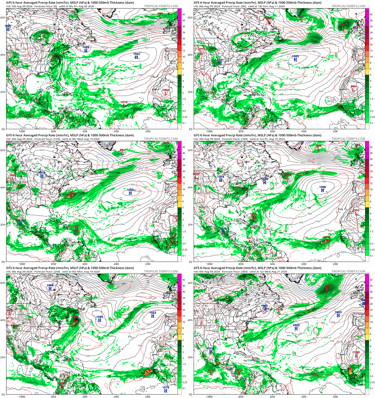
0z GFS (operational) shows a Nova Scotia landfall, and I'm surprised nobody has mentioned it yet. Once again shows everyone on the eastern seaboard has reasons to watch the storm. A bit weaker than last run, though.
Image
0 likes   

LarryWx
Category 5
Category 5
Posts: 6246
Joined: Sun Sep 07, 2003 2:04 pm
Location: GA

Re: Tropical Wave in Eastern Atlantic (0/50)

#98 Postby LarryWx » Fri Aug 09, 2024 12:39 am

Stratton23 wrote:More GEFS members are getting very close to florida fwiw


The mean of the 0Z GEFS is a bit further west than most of the recent runs implying a higher chance for a CONUS hit than those runs.
0 likes   
Personal Forecast Disclaimer:
The posts in this forum are NOT official forecasts and should not be used as such. They are just the opinion of the poster and may or may not be backed by sound meteorological data. They are NOT endorsed by any professional institution or storm2k.org. For official information, please refer to the NHC and NWS products.

LarryWx
Category 5
Category 5
Posts: 6246
Joined: Sun Sep 07, 2003 2:04 pm
Location: GA

Re: Tropical Wave in Eastern Atlantic (0/50)

#99 Postby LarryWx » Fri Aug 09, 2024 12:59 am

0Z Euro: heading N at 240 at 40N, 67W aiming toward E ME, New Brunswick, and Nova Scotia
0 likes   
Personal Forecast Disclaimer:
The posts in this forum are NOT official forecasts and should not be used as such. They are just the opinion of the poster and may or may not be backed by sound meteorological data. They are NOT endorsed by any professional institution or storm2k.org. For official information, please refer to the NHC and NWS products.

AxaltaRacing24
Category 5
Category 5
Posts: 1753
Age: 24
Joined: Wed Jul 27, 2016 11:14 am
Location: Jupiter, FL

Re: Tropical Wave in Eastern Atlantic (0/50)

#100 Postby AxaltaRacing24 » Fri Aug 09, 2024 1:22 am

LarryWx wrote:
Stratton23 wrote:More GEFS members are getting very close to florida fwiw


The mean of the 0Z GEFS is a bit further west than most of the recent runs implying a higher chance for a CONUS hit than those runs.

I mean, as somebody who lives in South Florida, I don’t necessary see signs that it’ll definitely be us. HOWEVER, to rule us (or any of the SEUS) out, when the setup is complex, along with ensembles pointing right at us, is simply irresponsible. Any of us who have been on this site since 2016 should know better than to do that.
2 likes   


Return to “Talkin' Tropics”

Who is online

Users browsing this forum: JaviT, Stormybajan and 92 guests