Tropical Wave in Eastern Atlantic (Is Invest 98L)

This is the general tropical discussion area. Anyone can take their shot at predicting a storms path.

Moderator: S2k Moderators

Forum rules

The posts in this forum are NOT official forecasts and should not be used as such. They are just the opinion of the poster and may or may not be backed by sound meteorological data. They are NOT endorsed by any professional institution or STORM2K. For official information, please refer to products from the National Hurricane Center and National Weather Service.

Help Support Storm2K
Message
Author
User avatar
N2FSU
S2K Supporter
S2K Supporter
Posts: 1062
Joined: Thu Sep 04, 2003 2:04 pm
Location: Tallahassee, FL

Re: Tropical Wave in Eastern Atlantic (0/60)

#121 Postby N2FSU » Fri Aug 09, 2024 7:29 am

6z GFS

Image


Sent from my iPad using Tapatalk
0 likes   

User avatar
chaser1
S2K Supporter
S2K Supporter
Posts: 5406
Age: 64
Joined: Sat Oct 15, 2005 5:59 pm
Location: Longwood, Fl

Re: Tropical Wave in Eastern Atlantic (0/50)

#122 Postby chaser1 » Fri Aug 09, 2024 7:30 am

Hurricaneman wrote:The 6zGFS shows a cat 3 impact to OBX this run


Yep, saw that too! I was surprised to see the shift west and took a look at the 500mb. Basically, (future) Ernesto packed well for his oceanic cruise and even brought his own private high-pressure ridge that travels west with him LOL. Not that common but we've seen that happen before.
1 likes   
Andy D

(For official information, please refer to the NHC and NWS products.)

User avatar
chaser1
S2K Supporter
S2K Supporter
Posts: 5406
Age: 64
Joined: Sat Oct 15, 2005 5:59 pm
Location: Longwood, Fl

Re: Tropical Wave in Eastern Atlantic (0/60)

#123 Postby chaser1 » Fri Aug 09, 2024 7:36 am

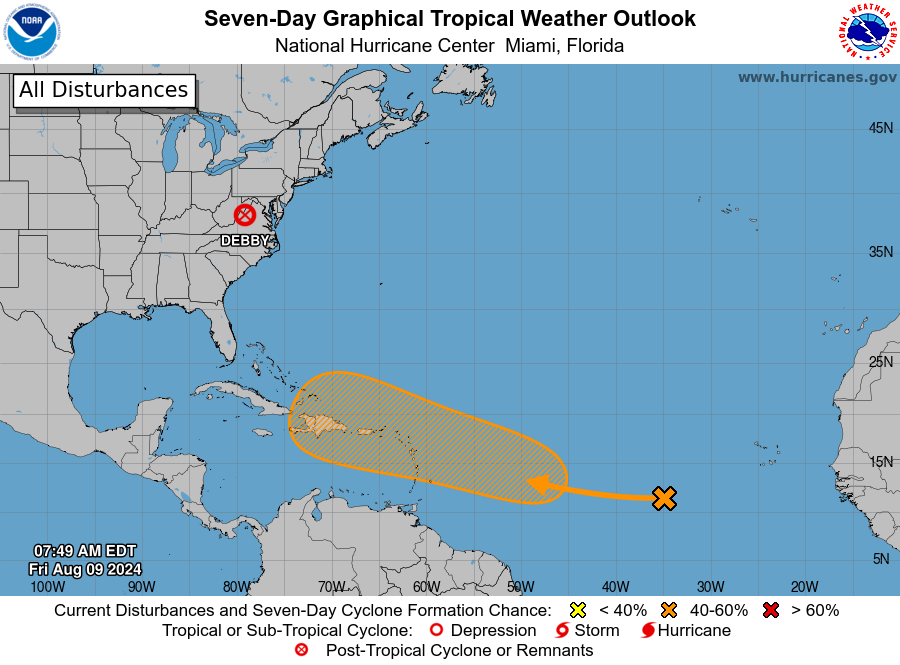
abajan wrote:Tropical Weather Outlook
NWS National Hurricane Center Miami FL
800 AM EDT Fri Aug 9 2024

For the North Atlantic...Caribbean Sea and the Gulf of Mexico:

Active Systems:
The Weather Prediction Center is issuing advisories on Post-Tropical
Cyclone Debby, located inland over the Mid-Atlantic region.

Near the Lesser and Greater Antilles:
A tropical wave located several hundred miles to the west-southwest
of the Cabo Verde Islands is producing a large area of disorganized
showers and thunderstorms over the tropical Atlantic. Any
development of the wave should be slow to occur during the next
couple of days while it moves westward across the central tropical
Atlantic. Afterwards, conditions are expected to become more
conducive for development while the wave moves west-northwestward,
and a tropical depression could form by early next week while the
system approaches the Lesser Antilles. The system is then forecast
to continue moving generally west-northwestward and could approach
the Greater Antilles by the middle part of next week.
* Formation chance through 48 hours...low...near 0 percent.
* Formation chance through 7 days...medium...60 percent.

$$
Forecaster Reinhart

https://i.postimg.cc/DwmHM6fg/two-atl-7d0.png


There's clear rotation but whether an ITCZ eddy or what NHC is eyeing, I couldn't say. Check out Tropical Tidbits Satellite page and select Goes 16 Sector 1, then increase speed to see rotation at 11N and 25W 8-)
0 likes   
Andy D

(For official information, please refer to the NHC and NWS products.)

User avatar
boca
Category 5
Category 5
Posts: 6365
Age: 60
Joined: Mon Dec 15, 2003 8:49 am
Location: Boca Raton,FL

Re: Tropical Wave in Eastern Atlantic (0/60)

#124 Postby boca » Fri Aug 09, 2024 7:39 am

Is the 6z GFS run a garbage run or that future Ernesto gets so strong they create their own environment. As of last night we are still dealing with a east coast trough.
0 likes   

Tekken_Guy
Tropical Storm
Tropical Storm
Posts: 135
Joined: Fri Sep 01, 2017 8:08 pm

Re: Tropical Wave in Eastern Atlantic (0/60)

#125 Postby Tekken_Guy » Fri Aug 09, 2024 7:42 am

boca wrote:Is the 6z GFS run a garbage run or that future Ernesto gets so strong they create their own environment. As of last night we are still dealing with a east coast trough.


There’s no trough on the 6z GFS and Ernesto goes much further west before making the turn.
0 likes   

User avatar
chaser1
S2K Supporter
S2K Supporter
Posts: 5406
Age: 64
Joined: Sat Oct 15, 2005 5:59 pm
Location: Longwood, Fl

Re: Tropical Wave in Eastern Atlantic (0/60)

#126 Postby chaser1 » Fri Aug 09, 2024 7:48 am

boca wrote:Is the 6z GFS run a garbage run or that future Ernesto gets so strong they create their own environment. As of last night we are still dealing with a east coast trough.


Rather than the storm rounding the southwest side of the mid-level ridge, GFS has the mid-level "bubble high" moving west along at a similar pace. Essentially, high pressure from the US builds underneath the Westerlies and the Atlantic high-pressure ridge builds westward. Still a weakness but per the 06Z, one that steers the storm into the Outer Banks.
0 likes   
Andy D

(For official information, please refer to the NHC and NWS products.)

Tekken_Guy
Tropical Storm
Tropical Storm
Posts: 135
Joined: Fri Sep 01, 2017 8:08 pm

Re: Tropical Wave in Eastern Atlantic (0/60)

#127 Postby Tekken_Guy » Fri Aug 09, 2024 8:11 am

How likely is NJ to get a hit?
0 likes   

User avatar
wxman57
Moderator-Pro Met
Moderator-Pro Met
Posts: 22950
Age: 67
Joined: Sat Jun 21, 2003 8:06 pm
Location: Houston, TX (southwest)

Re: Tropical Wave in Eastern Atlantic (0/60)

#128 Postby wxman57 » Fri Aug 09, 2024 8:36 am

chaser1 wrote:
There's clear rotation but whether an ITCZ eddy or what NHC is eyeing, I couldn't say. Check out Tropical Tidbits Satellite page and select Goes 16 Sector 1, then increase speed to see rotation at 11N and 25W 8-)


The primary wave axis is along 35-36W, well west of this small rotation.
1 likes   

User avatar
wxman57
Moderator-Pro Met
Moderator-Pro Met
Posts: 22950
Age: 67
Joined: Sat Jun 21, 2003 8:06 pm
Location: Houston, TX (southwest)

Re: Tropical Wave in Eastern Atlantic (0/60)

#129 Postby wxman57 » Fri Aug 09, 2024 8:42 am

Tekken_Guy wrote:How likely is NJ to get a hit?


That depends on how you define "hit". A direct impact by the center would be very unlikely, but not impossible. Chances of a storm brushing the coast and you getting some outer bands are higher than a direct hit, but maybe still not "high". It all depends on where this potential storm develops. The earlier it develops, the earlier it will recurve away from the east coast. Later development increases the risk of an impact along the east coast.
3 likes   

Andrewcane86
Tropical Wave
Tropical Wave
Posts: 5
Joined: Sun Jun 23, 2019 9:58 am

Re: Tropical Wave in Eastern Atlantic (0/60)

#130 Postby Andrewcane86 » Fri Aug 09, 2024 8:44 am

wxman57 wrote:
Tekken_Guy wrote:How likely is NJ to get a hit?


That depends on how you define "hit". A direct impact by the center would be very unlikely, but not impossible. Chances of a storm brushing the coast and you getting some outer bands are higher than a direct hit, but maybe still not "high". It all depends on where this potential storm develops. The earlier it develops, the earlier it will recurve away from the east coast. Later development increases the risk of an impact along the east coast.

Current thoughts on a potential SEFL impact?


Sent from my iPhone using Tapatalk
0 likes   

TomballEd
Category 2
Category 2
Posts: 578
Age: 61
Joined: Wed Aug 16, 2023 4:52 pm
Location: Spring/Klein area, not Tomball

Re: Tropical Wave in Eastern Atlantic (0/60)

#131 Postby TomballEd » Fri Aug 09, 2024 8:56 am

I have read the 6Z is the least accurate of the 4 daily runs. Not only does it not have balloon soundings, but the amount of aircraft ACCARs data is lower than 18Z.
0 likes   

TomballEd
Category 2
Category 2
Posts: 578
Age: 61
Joined: Wed Aug 16, 2023 4:52 pm
Location: Spring/Klein area, not Tomball

Re: Tropical Wave in Eastern Atlantic (0/60)

#132 Postby TomballEd » Fri Aug 09, 2024 8:59 am

Andrewcane86 wrote:
wxman57 wrote:
Tekken_Guy wrote:How likely is NJ to get a hit?


That depends on how you define "hit". A direct impact by the center would be very unlikely, but not impossible. Chances of a storm brushing the coast and you getting some outer bands are higher than a direct hit, but maybe still not "high". It all depends on where this potential storm develops. The earlier it develops, the earlier it will recurve away from the east coast. Later development increases the risk of an impact along the east coast.

Current thoughts on a potential SEFL impact?


Sent from my iPhone using Tapatalk


There are a few outliers on the ensemble, especially on the Euro ensembles, or, at this time it looks like SFL would be spared. But over a week away.
0 likes   

BobHarlem
Category 5
Category 5
Posts: 2034
Joined: Thu Oct 20, 2005 6:11 pm

Re: Tropical Wave in Eastern Atlantic (0/60)

#133 Postby BobHarlem » Fri Aug 09, 2024 9:01 am

Best summary, Most likely to stay offshore of the mainland US, Caribbean Islands need to watch closely. Bahamas maybe, and also Bermuda Maybe. If it struggles to develop the further west it'll go, if it strengthens early more likely to recurve early. S Florida/Gulf is very improbable with this current setup, but not impossible. 6z gfs is an outlier right now, 6z Euro Ensembles are to the right of 0z. My own idea is on a recurve right now with a toss up if it gets into the Bahamas or not (or Turks and Caicos) if that happens Bermuda needs to watch it.

Image
1 likes   

User avatar
Teban54
Category 5
Category 5
Posts: 3168
Joined: Sat May 19, 2018 1:19 pm

Re: Tropical Wave in Eastern Atlantic (0/60)

#134 Postby Teban54 » Fri Aug 09, 2024 9:13 am

6z GFS's solution with the extension of the UL ridge isn't totally wonky: ECMWF has been showing similar solutions for about 3 full runs now.
0 likes   

Tekken_Guy
Tropical Storm
Tropical Storm
Posts: 135
Joined: Fri Sep 01, 2017 8:08 pm

Re: Tropical Wave in Eastern Atlantic (0/60)

#135 Postby Tekken_Guy » Fri Aug 09, 2024 9:19 am

Teban54 wrote:6z GFS's solution with the extension of the UL ridge isn't totally wonky: ECMWF has been showing similar solutions for about 3 full runs now.


00z on the 8th is the only time the Euro ever brings it that far west. It recurves early in the other models.
0 likes   

User avatar
cheezyWXguy
Category 5
Category 5
Posts: 6091
Joined: Mon Feb 13, 2006 12:29 am
Location: Dallas, TX

Re: Tropical Wave in Eastern Atlantic (0/60)

#136 Postby cheezyWXguy » Fri Aug 09, 2024 9:53 am

Tekken_Guy wrote:
Teban54 wrote:6z GFS's solution with the extension of the UL ridge isn't totally wonky: ECMWF has been showing similar solutions for about 3 full runs now.


00z on the 8th is the only time the Euro ever brings it that far west. It recurves early in the other models.

Not quite, the 12z had a similar trajectory, albeit a little further east. The 00z this morning finished with it hooking west toward the northeast US/Canada
0 likes   

TomballEd
Category 2
Category 2
Posts: 578
Age: 61
Joined: Wed Aug 16, 2023 4:52 pm
Location: Spring/Klein area, not Tomball

Re: Tropical Wave in Eastern Atlantic (0/60)

#137 Postby TomballEd » Fri Aug 09, 2024 10:05 am

6Z GEFS has four Gulf 'leakers', they get 80*W before developing so they miss the trough. A couple of late bloomers try to get to Florida. Comment above about how fast the wave develops does seem rather important. Beyond that, 5 to 10 day 500 mb height forecasts can change a little.
0 likes   

User avatar
Spacecoast
Category 2
Category 2
Posts: 758
Joined: Thu Aug 31, 2017 2:03 pm

Re: Tropical Wave in Eastern Atlantic (0/60)

#138 Postby Spacecoast » Fri Aug 09, 2024 10:19 am

0z EPS Trop Storm Probabilty:

Image
0 likes   

LarryWx
Category 5
Category 5
Posts: 6246
Joined: Sun Sep 07, 2003 2:04 pm
Location: GA

Re: Tropical Wave in Eastern Atlantic (0/60)

#139 Postby LarryWx » Fri Aug 09, 2024 10:32 am

12Z ICON: recurve from SE Bahamas at 71-2W.
0 likes   
Personal Forecast Disclaimer:
The posts in this forum are NOT official forecasts and should not be used as such. They are just the opinion of the poster and may or may not be backed by sound meteorological data. They are NOT endorsed by any professional institution or storm2k.org. For official information, please refer to the NHC and NWS products.

User avatar
skyline385
Category 5
Category 5
Posts: 2728
Age: 34
Joined: Wed Aug 26, 2020 11:15 pm
Location: Houston TX

Re: Tropical Wave in Eastern Atlantic (0/60)

#140 Postby skyline385 » Fri Aug 09, 2024 10:36 am

With how favorable the conditions are near the islands on the models and especially after what we saw with Beryl, I have doubts that this struggles to be a TS before it reaches PR. I wouldn't be surprised if we see a TS before PR.
1 likes   


Return to “Talkin' Tropics”

Who is online

Users browsing this forum: cheezyWXguy, Ethaninfinity and 81 guests