Tropical Wave in Eastern Atlantic (Is Invest 98L)

This is the general tropical discussion area. Anyone can take their shot at predicting a storms path.

Moderator: S2k Moderators

Forum rules

The posts in this forum are NOT official forecasts and should not be used as such. They are just the opinion of the poster and may or may not be backed by sound meteorological data. They are NOT endorsed by any professional institution or STORM2K. For official information, please refer to products from the National Hurricane Center and National Weather Service.

Help Support Storm2K
Message
Author
TomballEd
Category 2
Category 2
Posts: 578
Age: 61
Joined: Wed Aug 16, 2023 4:52 pm
Location: Spring/Klein area, not Tomball

Re: Tropical Wave in Eastern Atlantic (0/60)

#141 Postby TomballEd » Fri Aug 09, 2024 10:44 am

skyline385 wrote:With how favorable the conditions are near the islands on the models and especially after what we saw with Beryl, I have doubts that this struggles to be a TS before it reaches PR. I wouldn't be surprised if we see a TS before PR.


Just checking, satellite looks much better than yesterday. Early formation increases the chances that no island in the Caribbean is affected and that CONUS landfall is less likely.
Image
0 likes   

User avatar
aspen
Category 5
Category 5
Posts: 8812
Joined: Sat Oct 12, 2019 7:10 pm
Location: Connecticut, USA

Re: Tropical Wave in Eastern Atlantic (0/60)

#142 Postby aspen » Fri Aug 09, 2024 11:07 am

12z GFS is coming in further south. Looks like it’s gonna go right through The Shredder this run.
0 likes   
Irene '11 Sandy '12 Hermine '16 5/15/2018 Derecho Fay '20 Isaias '20 Elsa '21 Henri '21 Ida '21

I am only a meteorology enthusiast who knows a decent amount about tropical cyclones. Look to the professional mets, the NHC, or your local weather office for the best information.

Stormlover70
Tropical Storm
Tropical Storm
Posts: 167
Age: 55
Joined: Fri Jun 21, 2024 5:31 am
Location: New port richey

Re: Tropical Wave in Eastern Atlantic (0/60)

#143 Postby Stormlover70 » Fri Aug 09, 2024 11:18 am

We all need a break after Beryl and Debby....
5 likes   

User avatar
SFLcane
S2K Supporter
S2K Supporter
Posts: 10162
Age: 47
Joined: Sat Jun 05, 2010 1:44 pm
Location: Lake Worth Florida

Re: Tropical Wave in Eastern Atlantic (0/60)

#144 Postby SFLcane » Fri Aug 09, 2024 11:27 am

Nice.. :double:

Image
0 likes   

User avatar
Nimbus
Category 5
Category 5
Posts: 5274
Joined: Mon Jul 19, 2004 10:54 am

Re: Tropical Wave in Eastern Atlantic (0/60)

#145 Postby Nimbus » Fri Aug 09, 2024 11:31 am

Less dry than it was for Beryl and Debbie so hoping we don't get an Andrew/Charley style trough split scenario.
0 likes   

User avatar
cheezyWXguy
Category 5
Category 5
Posts: 6091
Joined: Mon Feb 13, 2006 12:29 am
Location: Dallas, TX

Re: Tropical Wave in Eastern Atlantic (0/60)

#146 Postby cheezyWXguy » Fri Aug 09, 2024 11:31 am

I don’t really see a reason why it is slower to develop on the 12z than the 6z, so I don’t see a reason to buy the sw shift in the shorter term unless someone sees something I don’t. Otherwise, initial trough looks flatter and more progressive before the second lobe comes down and picks it up. That part seems as plausible as any other run, would make an east coast hit more likely if it verified
0 likes   

User avatar
Travorum
Category 1
Category 1
Posts: 406
Joined: Tue Sep 05, 2023 9:36 am
Location: Dunedin, FL

Re: Tropical Wave in Eastern Atlantic (0/60)

#147 Postby Travorum » Fri Aug 09, 2024 11:36 am

12Z GFS landfall near Wilmington NC
Image
0 likes   

User avatar
weeniepatrol
Category 5
Category 5
Posts: 1252
Joined: Sat Aug 22, 2020 5:30 pm
Location: WA State

Re: Tropical Wave in Eastern Atlantic (0/60)

#148 Postby weeniepatrol » Fri Aug 09, 2024 11:37 am

1 likes   

LarryWx
Category 5
Category 5
Posts: 6246
Joined: Sun Sep 07, 2003 2:04 pm
Location: GA

Re: Tropical Wave in Eastern Atlantic (0/60)

#149 Postby LarryWx » Fri Aug 09, 2024 11:42 am

12Z CMC: recurve E of Bermuda

12Z UKMET: forms NE of SE Bahamas moving N but shortly after turns NW:

NEW TROPICAL CYCLONE FORECAST TO DEVELOP AFTER 150 HOURS
FORECAST POSITION AT T+150 : 23.1N 71.7W

LEAD CENTRAL MAXIMUM WIND
VERIFYING TIME TIME POSITION PRESSURE (MB) SPEED (KNOTS)
-------------- ---- -------- ------------- -------------
0000UTC 16.08.2024 156 23.9N 71.7W 1007 37
1200UTC 16.08.2024 168 24.7N 72.5W 1005 36
1 likes   
Personal Forecast Disclaimer:
The posts in this forum are NOT official forecasts and should not be used as such. They are just the opinion of the poster and may or may not be backed by sound meteorological data. They are NOT endorsed by any professional institution or storm2k.org. For official information, please refer to the NHC and NWS products.

BobHarlem
Category 5
Category 5
Posts: 2034
Joined: Thu Oct 20, 2005 6:11 pm

Re: Tropical Wave in Eastern Atlantic (0/60)

#150 Postby BobHarlem » Fri Aug 09, 2024 11:49 am

Well today's 12z Canadian vs 12z GFS is kind of an extreme example of stronger right weaker left.
0 likes   

IsabelaWeather
Category 1
Category 1
Posts: 287
Age: 35
Joined: Tue Jul 07, 2020 7:29 am
Location: Isabela, Puerto Rico

Re: Tropical Wave in Eastern Atlantic (0/60)

#151 Postby IsabelaWeather » Fri Aug 09, 2024 11:50 am

Just checking, satellite looks much better than yesterday. Early formation increases the chances that no island in the Caribbean is affected and that CONUS landfall is less likely.
https://media.giphy.com/media/v1.Y2lkPTc5MGI3NjExc3FjczBmMDVmODV3aHJtMHY2dmxkaXJha25kMnUybThncjB5MnppdyZlcD12MV9pbnRlcm5hbF9naWZfYnlfaWQmY3Q9Zw/bJ8kUh0MwAK8511r4e/giphy.gif


What model shows that? Earlier development will be good for the CONUS, but I don't see how this storm safely misses the islands whether weak or strong. Theres not really anything to pick it up until ~72W

EDIT: CMC does but it appears to be the only one I have checked that does that. Icon, GFS, Euro and ensembles take the storm on a WNW track.
Last edited by IsabelaWeather on Fri Aug 09, 2024 11:51 am, edited 3 times in total.
0 likes   

User avatar
aspen
Category 5
Category 5
Posts: 8812
Joined: Sat Oct 12, 2019 7:10 pm
Location: Connecticut, USA

Re: Tropical Wave in Eastern Atlantic (0/60)

#152 Postby aspen » Fri Aug 09, 2024 11:50 am

12z CMC develops quickly and recurves sooner. Looks like it hits a wall at 60W, as it immediately turns to the north and doesn’t get much further west.
0 likes   
Irene '11 Sandy '12 Hermine '16 5/15/2018 Derecho Fay '20 Isaias '20 Elsa '21 Henri '21 Ida '21

I am only a meteorology enthusiast who knows a decent amount about tropical cyclones. Look to the professional mets, the NHC, or your local weather office for the best information.

User avatar
cheezyWXguy
Category 5
Category 5
Posts: 6091
Joined: Mon Feb 13, 2006 12:29 am
Location: Dallas, TX

Re: Tropical Wave in Eastern Atlantic (0/60)

#153 Postby cheezyWXguy » Fri Aug 09, 2024 11:54 am

12z gefs significantly more tightly clustered than 6z through hour 138, tracks near PR and DR

Edit: through hour 156 it maintains the 12z gfs’ idea of a flatter and more progressive trough. Looks like a large cluster of members are setting up in the southern Bahamas to track near the east coast like the op
0 likes   

User avatar
skyline385
Category 5
Category 5
Posts: 2728
Age: 34
Joined: Wed Aug 26, 2020 11:15 pm
Location: Houston TX

Re: Tropical Wave in Eastern Atlantic (0/60)

#154 Postby skyline385 » Fri Aug 09, 2024 12:19 pm

Deleted
Last edited by skyline385 on Fri Aug 09, 2024 12:36 pm, edited 1 time in total.
0 likes   

User avatar
cycloneye
Admin
Admin
Posts: 143863
Age: 68
Joined: Thu Oct 10, 2002 10:54 am
Location: San Juan, Puerto Rico

Re: Tropical Wave in Eastern Atlantic (0/60)

#155 Postby cycloneye » Fri Aug 09, 2024 12:20 pm

The squadron will be out there on Monday.

https://www.nhc.noaa.gov/text/MIAREPRPD.shtml

POSSIBLE LOW-LEVEL INVEST IN SUSPECT
AREA EAST OF THE LESSER ANTILLES NEAR 14.0N 54.0W FOR 12/1200Z.
2 likes   
Visit the Caribbean-Central America Weather Thread where you can find at first post web cams,radars
and observations from Caribbean basin members Click Here

User avatar
SouthFLTropics
Category 5
Category 5
Posts: 4236
Age: 49
Joined: Thu Aug 14, 2003 8:04 am
Location: Port St. Lucie, Florida

Re: Tropical Wave in Eastern Atlantic (0/60)

#156 Postby SouthFLTropics » Fri Aug 09, 2024 12:20 pm

That's the 00z Euro
0 likes   
Fourth Generation Florida Native

Personal Storm History: David 79, Andrew 92, Erin 95, Floyd 99, Irene 99, Frances 04, Jeanne 04, Wilma 05, Matthew 16, Irma 17, Ian 22, Nicole 22, Milton 24

User avatar
Hybridstorm_November2001
S2K Supporter
S2K Supporter
Posts: 2811
Joined: Sat Aug 21, 2004 2:50 pm
Location: SW New Brunswick, Canada
Contact:

Re: Tropical Wave in Eastern Atlantic (0/60)

#157 Postby Hybridstorm_November2001 » Fri Aug 09, 2024 12:37 pm

The long-range models have been all over the place with this one: SE Mass landfall (Euro control run yesterday), today we have Nova Scotia, The Carolinas & Newfoundland as possible landfalls. Anyone claiming this is a 100% OTS lock has no idea what they are talking about. It is far too early to tell. Stay tuned folks.
8 likes   

LarryWx
Category 5
Category 5
Posts: 6246
Joined: Sun Sep 07, 2003 2:04 pm
Location: GA

Re: Tropical Wave in Eastern Atlantic (0/60)

#158 Postby LarryWx » Fri Aug 09, 2024 12:47 pm

12Z Euro recurves up 70W and then at 240 heading in direction of SE Canada.
0 likes   
Personal Forecast Disclaimer:
The posts in this forum are NOT official forecasts and should not be used as such. They are just the opinion of the poster and may or may not be backed by sound meteorological data. They are NOT endorsed by any professional institution or storm2k.org. For official information, please refer to the NHC and NWS products.

User avatar
cycloneye
Admin
Admin
Posts: 143863
Age: 68
Joined: Thu Oct 10, 2002 10:54 am
Location: San Juan, Puerto Rico

Re: Tropical Wave in Eastern Atlantic (0/60)

#159 Postby cycloneye » Fri Aug 09, 2024 12:51 pm

Hybridstorm_November2001 wrote:The long-range models have been all over the place with this one: SE Mass landfall (Euro control run yesterday), today we have Nova Scotia, The Carolinas & Newfoundland as possible landfalls. Anyone claiming this is a 100% OTS lock has no idea what they are talking about. It is far too early to tell. Stay tuned folks.


Until there is a invest, there is a low pressure and recon data from monday, the models will do better from that point.
1 likes   
Visit the Caribbean-Central America Weather Thread where you can find at first post web cams,radars
and observations from Caribbean basin members Click Here

User avatar
cycloneye
Admin
Admin
Posts: 143863
Age: 68
Joined: Thu Oct 10, 2002 10:54 am
Location: San Juan, Puerto Rico

Re: Tropical Wave in Eastern Atlantic (0/60)

#160 Postby cycloneye » Fri Aug 09, 2024 12:53 pm

Nothing new at 2 PM.

Tropical Weather Outlook
NWS National Hurricane Center Miami FL
200 PM EDT Fri Aug 9 2024

For the North Atlantic...Caribbean Sea and the Gulf of Mexico:

Active Systems:
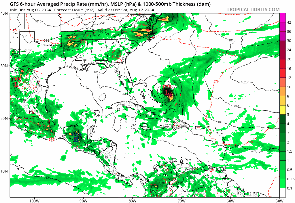
The Weather Prediction Center is issuing advisories on Post-Tropical
Cyclone Debby, located inland over the northeastern United States.

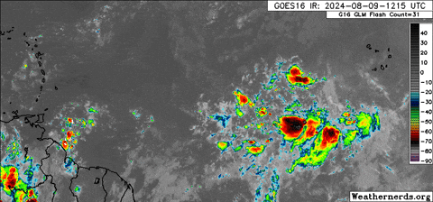
Near the Lesser and Greater Antilles:
A large area of disorganized showers and thunderstorms located well
to the west-southwest of the Cabo Verde Islands over the tropical
Atlantic is associated with a tropical wave. Any development of the
wave should be slow to occur during the next couple of days while it
moves westward to west-northwestward across the central tropical
Atlantic. Conditions are expected to become more conducive for
development thereafter, and a tropical depression could form by
early next week while the system approaches and then moves near or
over the Lesser Antilles. The system is forecast to continue moving
generally west-northwestward and could approach portions of the
Greater Antilles by the middle part of next week.
* Formation chance through 48 hours...low...near 0 percent.
* Formation chance through 7 days...medium...60 percent.

$$
Forecaster Reinhart
1 likes   
Visit the Caribbean-Central America Weather Thread where you can find at first post web cams,radars
and observations from Caribbean basin members Click Here


Return to “Talkin' Tropics”

Who is online

Users browsing this forum: ouragans and 77 guests