Tropical Wave in Eastern Atlantic (Is Invest 98L)
Moderator: S2k Moderators
Forum rules

The posts in this forum are NOT official forecasts and should not be used as such. They are just the opinion of the poster and may or may not be backed by sound meteorological data. They are NOT endorsed by any professional institution or STORM2K. For official information, please refer to products from the National Hurricane Center and National Weather Service.

Re: Tropical Wave in Eastern Atlantic (0/60)
recurve safely away from the us coast seems more and more likely.......
0 likes
-
Category5Kaiju

- Category 5

- Posts: 4345
- Joined: Thu Dec 24, 2020 12:45 pm
- Location: Seattle during the summer, Phoenix during the winter
Re: Tropical Wave in Eastern Atlantic (0/60)
mantis83 wrote:recurve safely away from the us coast seems more and more likely.......
North Carolina: “And I took that personally”
8 likes
Unless explicitly stated, all information in my posts is based on my own opinions and observations. Tropical storms and hurricanes can be extremely dangerous. Refer to an accredited weather research agency or meteorologist if you need to make serious decisions regarding an approaching storm.
-
Andrewcane86
- Tropical Wave

- Posts: 5
- Joined: Sun Jun 23, 2019 9:58 am
Re: Tropical Wave in Eastern Atlantic (0/60)
mantis83 wrote:recurve safely away from the us coast seems more and more likely.......
Latest GFS would like a word.
Sent from my iPhone using Tapatalk
3 likes


Re: Tropical Wave in Eastern Atlantic (0/60)
Just like we have seen so far this season I would recommend not to trust the models past their 96/120 hr forecast or at least until we have an actual system form.
Just like I told Andy Hazelton with Debby anything is possible past the 120 hr models' forecast range.
Just like I told Andy Hazelton with Debby anything is possible past the 120 hr models' forecast range.
4 likes
-
TomballEd
- Category 5
- Posts: 1318
- Age: 62
- Joined: Wed Aug 16, 2023 4:52 pm
- Location: Spring/Klein area, not Tomball
Re: Tropical Wave in Eastern Atlantic (0/60)
Most GFS ensembles are E of the op. Again, without being able to see the control run of the ensemble, I don't know if that means minute changes to initial conditions, or lower ensemble member resolution that has the GEFS mostly E of the op.
0 likes

Re: Tropical Wave in Eastern Atlantic (0/60)
mantis83 wrote:recurve safely away from the us coast seems more and more likely.......
"Safely" unless you're in Puerto Rico, or Hispaniola, or the Leeward Islands, or the Bahamas. Or Atlantic Canada. And that's setting aside the fact that some deterministic runs, including the most recent GFS, still show potential continental US impacts, to the Outer Banks or New England. In fact, AFAICT only the CMC shows recurvature prior to any land impacts. I'm no professional but I feel like the best approach to areas of interest like this early in development is to watch closely and not write off possibilities prematurely - speculating that this one's "safe" minimises the risks that any and all tropical systems pose until they've dissipated.
10 likes
-
ScottNAtlanta

- Category 5
- Posts: 2535
- Joined: Sat May 25, 2013 3:11 pm
- Location: Atlanta, GA
Re: Tropical Wave in Eastern Atlantic (0/60)
I've been offline for a couple of days due to family emergency, but looking at this for the first time...I have a couple of observations.
1. If you get that trough split...that is a classic sign for a New England hit where the cut off low pulls in the tropical feature
2. Models are gonna model and what they say this run will not be the same as next run. That will happen for the next several days out.
3. The MJO modeling keeps correcting to higher amplitude phases 1,2 and 3 (which it tends to almost always do this time of year) which are the GoGo phases for Atlantic hurricanes with a US hit.
4. I'm not seeing an OTS currently, but that could change.
5. There will probably be something right on the heals of this feature as the Atlantic will be just about as favorable as it can get...so strap in...gonna be a wild ride.
7 likes
The posts in this forum are NOT official forecast and should not be used as such. They are just the opinion of the poster and may or may not be backed by sound meteorological data. They are NOT endorsed by any professional institution or storm2k.org. For official information, please refer to the NHC and NWS products.
-
TomballEd
- Category 5
- Posts: 1318
- Age: 62
- Joined: Wed Aug 16, 2023 4:52 pm
- Location: Spring/Klein area, not Tomball
Re: Tropical Wave in Eastern Atlantic (0/60)
Looking at the ensemble mean height, US landfall looks very unlikely. Standard caveat on exact position of the trough, strength of the ridge, and how fast this develops. Wildcard, impossible to tell, is which, if any, of the Greater Antilles the system makes landfall.
16 years ago, but Hurricane Ike NHC forecast was out to sea early, then a slow adjustment closer and closer to ECUSA, then finally a forecast from Turks and Caicos to Cuba. Models have been approved, but that is not like the days of NGM and AVN.
16 years ago, but Hurricane Ike NHC forecast was out to sea early, then a slow adjustment closer and closer to ECUSA, then finally a forecast from Turks and Caicos to Cuba. Models have been approved, but that is not like the days of NGM and AVN.
3 likes
-
cycloneye

- Admin

- Posts: 149696
- Age: 69
- Joined: Thu Oct 10, 2002 10:54 am
- Location: San Juan, Puerto Rico
Re: Tropical Wave in Eastern Atlantic (0/60)
Levi Cowan's take.
https://x.com/TropicalTidbits/status/1821975112385753493
A new tropical wave west of Africa will be monitored for development next week as it tracks towards the Lesser Antilles in a favorable environment. The disturbance is currently broad and likely to organize only gradually during the weekend, but a tropical storm could form after that, with a significant fraction of GEFS and EPS ensemble members supporting that outcome. Arrival in the Lesser Antilles is expected Monday or Tuesday, but it's too early to know what impacts the system may bring, as we don't have a well-defined storm yet.
It's also too early to speculate much on the system's potential long-term track beyond the Lesser Antilles. The western Atlantic is forecast to be occupied by an upper-level longwave trough next week, meaning that the potential for this disturbance to threaten the Greater Antilles, Bahamas, and North America will be highly sensitive to how far north the system tracks near the eastern Caribbean. As always, greater clarity will come once a storm actually forms, if one indeed does.
It's also too early to speculate much on the system's potential long-term track beyond the Lesser Antilles. The western Atlantic is forecast to be occupied by an upper-level longwave trough next week, meaning that the potential for this disturbance to threaten the Greater Antilles, Bahamas, and North America will be highly sensitive to how far north the system tracks near the eastern Caribbean. As always, greater clarity will come once a storm actually forms, if one indeed does.
https://x.com/TropicalTidbits/status/1821975112385753493
2 likes
Visit the Caribbean-Central America Weather Thread where you can find at first post web cams,radars
and observations from Caribbean basin members Click Here
and observations from Caribbean basin members Click Here
-
cheezyWXguy

- Category 5
- Posts: 6282
- Joined: Mon Feb 13, 2006 12:29 am
- Location: Dallas, TX
Re: Tropical Wave in Eastern Atlantic (0/60)
mantis83 wrote:recurve safely away from the us coast seems more and more likely.......
Can you give your reasoning for this?
0 likes
-
Category5Kaiju
- Category 5
- Posts: 4345
- Joined: Thu Dec 24, 2020 12:45 pm
- Location: Seattle during the summer, Phoenix during the winter
Re: Tropical Wave in Eastern Atlantic (0/60)
cheezyWXguy wrote:mantis83 wrote:recurve safely away from the us coast seems more and more likely.......
Can you give your reasoning for this?
For some reason that specific user literally comments nothing but “oh the storm is going OTS.” Like, the same thing was said when Debby happened iirc. Imho doesn’t really add anything meaningful or significant to the overall discussion.
11 likes
Unless explicitly stated, all information in my posts is based on my own opinions and observations. Tropical storms and hurricanes can be extremely dangerous. Refer to an accredited weather research agency or meteorologist if you need to make serious decisions regarding an approaching storm.
-
IsabelaWeather
- Category 1

- Posts: 316
- Age: 36
- Joined: Tue Jul 07, 2020 7:29 am
- Location: Isabela, Puerto Rico
Re: Tropical Wave in Eastern Atlantic (0/60)
Category5Kaiju wrote:cheezyWXguy wrote:mantis83 wrote:recurve safely away from the us coast seems more and more likely.......
Can you give your reasoning for this?
For some reason that specific user literally comments nothing but “oh the storm is going OTS.” Like, the same thing was said when Debby happened iirc. Imho doesn’t really add anything meaningful or significant to the overall discussion.
Happened to most storms last year, too.
1 likes
Re: Tropical Wave in Eastern Atlantic (0/60)
12Z EPS: more spread out than 0Z but with mean path a little to the left of 0Z. The operational was fairly close to the EPS mean path. There’s still very little in the Gulf, a few at or near SE FL, some that hit further up the US E coast, and the majority still staying offshore the E US. A decent % of those, however, later hit SE Canada. Still a long way to go and lots of uncertainty this far out.
2 likes
Personal Forecast Disclaimer:
The posts in this forum are NOT official forecasts and should not be used as such. They are just the opinion of the poster and may or may not be backed by sound meteorological data. They are NOT endorsed by any professional institution or storm2k.org. For official information, please refer to the NHC and NWS products.
The posts in this forum are NOT official forecasts and should not be used as such. They are just the opinion of the poster and may or may not be backed by sound meteorological data. They are NOT endorsed by any professional institution or storm2k.org. For official information, please refer to the NHC and NWS products.

Re: Tropical Wave in Eastern Atlantic (0/60)
I would not say OTS yet because the trough that is expected to be across the eastern US can be weaker than forecast and the atmosphere is always changing so Florida can possibly be in play as well. The Bermuda High can build in quicker as well.
0 likes
Re: Tropical Wave in Eastern Atlantic (0/60)
cheezyWXguy wrote:mantis83 wrote:recurve safely away from the us coast seems more and more likely.......
Can you give your reasoning for this?
euro and cmc have the ridge that has been dominating the west atlantic all summer moving east, being replaced by troughing. the gfs also has this same scenario. gfs has the storm weaker and further south while also rebuilding the ridge back west more than the other models.as others have pointed out, gfs ensembles are east of op........
the overall pattern to me screams recurve
0 likes
Re: Tropical Wave in Eastern Atlantic (0/60)
sasha_B wrote:mantis83 wrote:recurve safely away from the us coast seems more and more likely.......
"Safely" unless you're in Puerto Rico, or Hispaniola, or the Leeward Islands, or the Bahamas. Or Atlantic Canada. And that's setting aside the fact that some deterministic runs, including the most recent GFS, still show potential continental US impacts, to the Outer Banks or New England. In fact, AFAICT only the CMC shows recurvature prior to any land impacts. I'm no professional but I feel like the best approach to areas of interest like this early in development is to watch closely and not write off possibilities prematurely - speculating that this one's "safe" minimises the risks that any and all tropical systems pose until they've dissipated.
In all fairness, mantis83 didn’t actually “write-off” a CONUS threat but instead is saying the threat is low and lowering, which is that poster’s opinion and one he/she’s entitled to voice. If mantis had said the CONUS is definitely not going to be hit, that would be writing it off and even I’d question something that strong this far out. But he didn’t.
Last edited by LarryWx on Fri Aug 09, 2024 2:09 pm, edited 1 time in total.
1 likes
Personal Forecast Disclaimer:
The posts in this forum are NOT official forecasts and should not be used as such. They are just the opinion of the poster and may or may not be backed by sound meteorological data. They are NOT endorsed by any professional institution or storm2k.org. For official information, please refer to the NHC and NWS products.
The posts in this forum are NOT official forecasts and should not be used as such. They are just the opinion of the poster and may or may not be backed by sound meteorological data. They are NOT endorsed by any professional institution or storm2k.org. For official information, please refer to the NHC and NWS products.
Re: Tropical Wave in Eastern Atlantic (0/60)
mantis83 wrote:cheezyWXguy wrote:mantis83 wrote:recurve safely away from the us coast seems more and more likely.......
Can you give your reasoning for this?
euro and cmc have the ridge that has been dominating the west atlantic all summer moving east, being replaced by troughing. the gfs also has this same scenario. gfs has the storm weaker and further south while also rebuilding the ridge back west more than the other models.as others have pointed out, gfs ensembles are east of op........
the overall pattern to me screams recurve
The Bermuda high has been stronger this year that’s why I’m just saying things can change.
0 likes
-
skyline385

- Category 5
- Posts: 2728
- Age: 35
- Joined: Wed Aug 26, 2020 11:15 pm
- Location: Houston TX
Re: Tropical Wave in Eastern Atlantic (0/60)
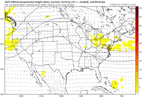
12z EPS, ensembles starting to consolidate slightly

1 likes

Re: Tropical Wave in Eastern Atlantic (0/60)
Look at that one ensemble member has a Cat 1/2 hit in the NYC area. Thankfully it’s an outlier for now.
0 likes
Irene '11 Sandy '12 Hermine '16 5/15/2018 Derecho Fay '20 Isaias '20 Elsa '21 Henri '21 Ida '21
I am only a meteorology enthusiast who knows a decent amount about tropical cyclones. Look to the professional mets, the NHC, or your local weather office for the best information.
I am only a meteorology enthusiast who knows a decent amount about tropical cyclones. Look to the professional mets, the NHC, or your local weather office for the best information.
-
cheezyWXguy
- Category 5
- Posts: 6282
- Joined: Mon Feb 13, 2006 12:29 am
- Location: Dallas, TX
Re: Tropical Wave in Eastern Atlantic (0/60)
mantis83 wrote:cheezyWXguy wrote:mantis83 wrote:recurve safely away from the us coast seems more and more likely.......
Can you give your reasoning for this?
euro and cmc have the ridge that has been dominating the west atlantic all summer moving east, being replaced by troughing. the gfs also has this same scenario. gfs has the storm weaker and further south while also rebuilding the ridge back west more than the other models.as others have pointed out, gfs ensembles are east of op........
the overall pattern to me screams recurve
First of all, I appreciate you giving some reasoning to back up your case. You’ve gotten a fair bit of flack for your posts (I’m pretty sure from myself as well) for making assertions that most would claim don’t have sufficient evidence to back up that degree of confidence. I think posts like this one would do better at keeping responses like that at bay.
That said, I do disagree with your original post that a recurve looks “more and more likely”. I think you’re right if you say a recurve is more likely in general, as that outcome has a higher statistical likelihood by default without even looking at models. However, I don’t think the results of the 12z model suite have increased the likelihood beyond what it was prior.
For example at time of your post, the gfs had just shifted west and while we agree that this shift may be due to the gfs erroneously keeping it weaker in the short term, it’s probably also due to the flatter and more progressive nature of the trough, which lifts out faster and allows more ridging to build in. This is also observed in the 12z gefs, which results in a little tighter clustering of the members toward the western side of the envelope. But yes, plenty still recurve, and there are other ops like the cmc that show this as well. The euro is kind of a mixed bag, as the last several 240hr runs take the storm on approach to the coast, but vary on approach each time and don’t go far enough out to see the end result.
I think what I personally take issue with is that there seems to be no acknowledgment of the evidence that runs counter to your argument. There is some, and while it’s a minority among the forecast tools available, it still does warrant some consideration since we are still so far out. If you want to discard it, so be it, but people are probably going to ask why you are so confident in doing so. Not acknowledging the existing uncertainty gives the impression that you’re hoping the storm away rather than giving a good faith evaluation of the setup.
12 likes
Who is online
Users browsing this forum: No registered users and 202 guests