ATL: ERNESTO - Models
Moderator: S2k Moderators
-
gatorcane

- S2K Supporter

- Posts: 23708
- Age: 48
- Joined: Sun Mar 13, 2005 3:54 pm
- Location: Boca Raton, FL
Re: ATL: INVEST 98L - Models
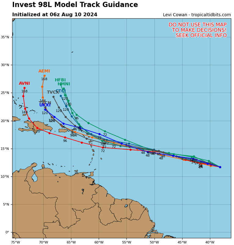
06Z TVCN consensus track is north of Puerco Rico and the islands with a fairly sharp recurve:
0 likes

Re: ATL: INVEST 98L - Models
6z HWRF is slower to develop (takes until 66-72hrs out) and goes south of the Virgin Islands. Much more in-line with the GFS and Euro’s short-term (<5d) track and evolution.
0 likes
Irene '11 Sandy '12 Hermine '16 5/15/2018 Derecho Fay '20 Isaias '20 Elsa '21 Henri '21 Ida '21
I am only a meteorology enthusiast who knows a decent amount about tropical cyclones. Look to the professional mets, the NHC, or your local weather office for the best information.
I am only a meteorology enthusiast who knows a decent amount about tropical cyclones. Look to the professional mets, the NHC, or your local weather office for the best information.
-
cycloneye

- Admin

- Posts: 149698
- Age: 69
- Joined: Thu Oct 10, 2002 10:54 am
- Location: San Juan, Puerto Rico
Re: ATL: INVEST 98L - Models
Cat 1 crossing PR from HWRF.

1 likes
Visit the Caribbean-Central America Weather Thread where you can find at first post web cams,radars
and observations from Caribbean basin members Click Here
and observations from Caribbean basin members Click Here
-
cycloneye
- Admin
- Posts: 149698
- Age: 69
- Joined: Thu Oct 10, 2002 10:54 am
- Location: San Juan, Puerto Rico
Re: ATL: INVEST 98L - Models

0 likes
Visit the Caribbean-Central America Weather Thread where you can find at first post web cams,radars
and observations from Caribbean basin members Click Here
and observations from Caribbean basin members Click Here
-
hurricaneCW
- Category 5

- Posts: 1799
- Joined: Wed Mar 03, 2010 6:20 am
- Location: Toms River, NJ
Re: ATL: INVEST 98L - Models
This will get close to the islands and PR at least followed by a sharp recurve OTS
Lots of western Atlantic troughing to keep the US safe
Lots of western Atlantic troughing to keep the US safe
0 likes
Re: ATL: INVEST 98L - Models
HMON develops 98L in only about 48 hours, which gets it stronger earlier and allows it to recurve sooner. Bermuda might be under threat in such a scenario.
HAFS-A/B are having a very hard time with 98L. Both struggle to develop it and only have a marginal TS passing through the northwestern Caribbean islands.
Even though the HWRF is on the leftmost side of the guidance envelope, that track should thread the needle between the US and Bermuda, possibly putting Atlantic Canada at risk. Additionally, 98L getting further west puts it over warmer SSTs with a higher ceiling of the system’s structure can recover after Puerto Rico. Its modeled UL environment for 98L by the end of the run looks quite good.
1 likes
Irene '11 Sandy '12 Hermine '16 5/15/2018 Derecho Fay '20 Isaias '20 Elsa '21 Henri '21 Ida '21
I am only a meteorology enthusiast who knows a decent amount about tropical cyclones. Look to the professional mets, the NHC, or your local weather office for the best information.
I am only a meteorology enthusiast who knows a decent amount about tropical cyclones. Look to the professional mets, the NHC, or your local weather office for the best information.
-
cheezyWXguy

- Category 5
- Posts: 6282
- Joined: Mon Feb 13, 2006 12:29 am
- Location: Dallas, TX
Re: ATL: INVEST 98L - Models
If the trough evolution plays out the way the latest gfs and euro show, the chances of an east coast hit go down significantly from yesterday. Even Canada’s chances decrease, though are probably a little higher than the US’s. Since it’s still so early this isn’t a sure thing though.
0 likes
Re: ATL: INVEST 98L - Models
6z Euro Ensembles, right shift from 0z.

Biggest questions, if it gets into the Turks and Caicos, how much into the Islands, and Bermuda. Any direct US Mainland impact looks terribly unlikely at least.
Biggest questions, if it gets into the Turks and Caicos, how much into the Islands, and Bermuda. Any direct US Mainland impact looks terribly unlikely at least.
0 likes
Re: ATL: INVEST 98L - Models
Good morning Luis......I sure do hope that yall will not experience this as a hurricane....that goes without saying it....but I have a question....from what I read here...this system may recurve?...what is the reason for this?....the red highlighted area looks to be close to Florida....thanks for any light u can shed on this....have a great day!...
1 likes
-
cycloneye
- Admin
- Posts: 149698
- Age: 69
- Joined: Thu Oct 10, 2002 10:54 am
- Location: San Juan, Puerto Rico
Re: ATL: INVEST 98L - Models
underthwx wrote:
Good morning Luis......I sure do hope that yall will not experience this as a hurricane....that goes without saying it....but I have a question....from what I read here...this system may recurve?...what is the reason for this?....the red highlighted area looks to be close to Florida....thanks for any light u can shed on this....have a great day!...
Good morning. There may be an upper trough near the east coast of U.S that may cause it to recurve but if that happens, the question is how large it may be, or have a more closer route to the coast and reach Atlantic Canada.
1 likes
Visit the Caribbean-Central America Weather Thread where you can find at first post web cams,radars
and observations from Caribbean basin members Click Here
and observations from Caribbean basin members Click Here
Re: ATL: INVEST 98L - Models
12z GFS has genesis between Monday afternoon and Tuesday morning. Slides well south of the Virgin Islands and PR, makes landfall in the DR with a pressure in the upper 960s.
ICON is a clear, sharp recurve that slides east of Bermuda.
ICON is a clear, sharp recurve that slides east of Bermuda.
0 likes
Irene '11 Sandy '12 Hermine '16 5/15/2018 Derecho Fay '20 Isaias '20 Elsa '21 Henri '21 Ida '21
I am only a meteorology enthusiast who knows a decent amount about tropical cyclones. Look to the professional mets, the NHC, or your local weather office for the best information.
I am only a meteorology enthusiast who knows a decent amount about tropical cyclones. Look to the professional mets, the NHC, or your local weather office for the best information.
Re: ATL: INVEST 98L - Models
12z GFS (plus previous runs) is basically just Fiona ‘22 redux. Like Fiona, it does due west into the NE Caribbean before turning north into Hispaniola and passing between the CONUS and Bermuda.
12z CMC is much closer to an Earl ‘22-esqe track. A hair north of the NE Caribbean islands, recurving just east of Bermuda.
12z ICON is right in the middle: goes through the NE islands and Hispaniola, recurves between the GFS and CMC.
12z CMC is much closer to an Earl ‘22-esqe track. A hair north of the NE Caribbean islands, recurving just east of Bermuda.
12z ICON is right in the middle: goes through the NE islands and Hispaniola, recurves between the GFS and CMC.
0 likes
Irene '11 Sandy '12 Hermine '16 5/15/2018 Derecho Fay '20 Isaias '20 Elsa '21 Henri '21 Ida '21
I am only a meteorology enthusiast who knows a decent amount about tropical cyclones. Look to the professional mets, the NHC, or your local weather office for the best information.
I am only a meteorology enthusiast who knows a decent amount about tropical cyclones. Look to the professional mets, the NHC, or your local weather office for the best information.
-
cheezyWXguy
- Category 5
- Posts: 6282
- Joined: Mon Feb 13, 2006 12:29 am
- Location: Dallas, TX
Re: ATL: INVEST 98L - Models
The 12z gfs is close to being a very bad run for the ne US. That trough evolution, but further southwest would slingshot it into the coast. Not a particularly likely outcome, and I feel like the globals always show a run or two like this for every recurving storm, but still something to watch for.
1 likes
-
OuterBanker
- S2K Supporter
- Posts: 1761
- Joined: Wed Feb 26, 2003 10:53 am
- Location: Nags Head, NC
- Contact:
Re: ATL: INVEST 98L - Models
Luis may have to deal with a hurricane. All models are showing a recurve around 70w.
I call it a field goal hurricane. Typical route around 70 w. Between Hatteras and Bermuda Quite common.
Strong trough and a weaker Bermuda high. Typical east coast force field.
Unlike Debby where models were all over the place. Ernesto pretty close to set in stone.
I call it a field goal hurricane. Typical route around 70 w. Between Hatteras and Bermuda Quite common.
Strong trough and a weaker Bermuda high. Typical east coast force field.
Unlike Debby where models were all over the place. Ernesto pretty close to set in stone.
0 likes

Re: ATL: INVEST 98L - Models
zzzh wrote:GFS 06/18z runs are considerably stronger than 00/12z runs, I wouldn't trust it too much.
12z GFS today: Hold my beer
1 likes
TC naming lists: retirements and intensity
Most aggressive Advisory #1's in North Atlantic (cr. kevin for starting the list)
Most aggressive Advisory #1's in North Atlantic (cr. kevin for starting the list)
-
OuterBanker
- S2K Supporter
- Posts: 1761
- Joined: Wed Feb 26, 2003 10:53 am
- Location: Nags Head, NC
- Contact:
Re: ATL: INVEST 98L - Models
Luis may have to deal with a hurricane. All models are showing a recurve around 70w.
I call it a field goal hurricane. Typical route around 70 w. Between Hatteras and Bermuda Quite common.
Strong trough and a weaker Bermuda high. Typical east coast force field.
Unlike Debby where models were all over the place. Ernesto pretty close to set in stone.
I call it a field goal hurricane. Typical route around 70 w. Between Hatteras and Bermuda Quite common.
Strong trough and a weaker Bermuda high. Typical east coast force field.
Unlike Debby where models were all over the place. Ernesto pretty close to set in stone.
0 likes
-
Blown Away

- S2K Supporter
- Posts: 10253
- Joined: Wed May 26, 2004 6:17 am
Re: ATL: INVEST 98L - Models
Pretty significant SW shift in many of the GEFS in the 12z run. Many going through PR and Hispaniola before making the turn.
0 likes
Hurricane Eye Experience: David 79, Irene 99, Frances 04, Jeanne 04, Wilma 05… Hurricane Brush Experience: Andrew 92, Erin 95, Floyd 99, Matthew 16, Irma 17, Ian 22, Nicole 22…
-
Tekken_Guy
- Tropical Storm

- Posts: 150
- Joined: Fri Sep 01, 2017 8:08 pm
Re: ATL: INVEST 98L - Models
cheezyWXguy wrote:The 12z gfs is close to being a very bad run for the ne US. That trough evolution, but further southwest would slingshot it into the coast. Not a particularly likely outcome, and I feel like the globals always show a run or two like this for every recurving storm, but still something to watch for.
Is NYC still in play, or is it mostly New England at this point?
0 likes
Re: ATL: INVEST 98L - Models
12Z UK: recurve 69W; turns NW at 28N
NEW TROPICAL CYCLONE FORECAST TO DEVELOP AFTER 108 HOURS
FORECAST POSITION AT T+108 : 20.8N 68.7W
LEAD CENTRAL MAXIMUM WIND
VERIFYING TIME TIME POSITION PRESSURE (MB) SPEED (KNOTS)
-------------- ---- -------- ------------- -------------
0000UTC 15.08.2024 108 20.8N 68.7W 1009 32
1200UTC 15.08.2024 120 24.0N 68.7W 1008 40
0000UTC 16.08.2024 132 25.4N 68.4W 1005 48
1200UTC 16.08.2024 144 26.7N 67.5W 1003 44
0000UTC 17.08.2024 156 28.0N 67.2W 1001 44
1200UTC 17.08.2024 168 28.7N 67.9W 1001 41
0 likes
Personal Forecast Disclaimer:
The posts in this forum are NOT official forecasts and should not be used as such. They are just the opinion of the poster and may or may not be backed by sound meteorological data. They are NOT endorsed by any professional institution or storm2k.org. For official information, please refer to the NHC and NWS products.
The posts in this forum are NOT official forecasts and should not be used as such. They are just the opinion of the poster and may or may not be backed by sound meteorological data. They are NOT endorsed by any professional institution or storm2k.org. For official information, please refer to the NHC and NWS products.
Re: ATL: INVEST 98L - Models
12Z Euro: TS E PR, recurve 67W, just SE of Berm. as cat 2
0 likes
Personal Forecast Disclaimer:
The posts in this forum are NOT official forecasts and should not be used as such. They are just the opinion of the poster and may or may not be backed by sound meteorological data. They are NOT endorsed by any professional institution or storm2k.org. For official information, please refer to the NHC and NWS products.
The posts in this forum are NOT official forecasts and should not be used as such. They are just the opinion of the poster and may or may not be backed by sound meteorological data. They are NOT endorsed by any professional institution or storm2k.org. For official information, please refer to the NHC and NWS products.
Who is online
Users browsing this forum: No registered users and 90 guests