Florida Weather

U.S. & Caribbean Weather Discussions and Severe Weather Events

Moderator: S2k Moderators

Forum rules

The posts in this forum are NOT official forecast and should not be used as such. They are just the opinion of the poster and may or may not be backed by sound meteorological data. They are NOT endorsed by any professional institution or STORM2K.

Help Support Storm2K
Message
Author
LarryWx
S2K Supporter
S2K Supporter
Posts: 6304
Joined: Sun Sep 07, 2003 2:04 pm
Location: GA

Re: Florida Weather

#17641 Postby LarryWx » Fri Jun 14, 2024 8:11 am

jlauderdal wrote:
LarryWx wrote:Due to the widespread heavy rains and clouds, Key West buoy water temp dropped from 32.0C 4 days ago to 30.0C now.

We were lucky in SE Florida; the complex was winding up and hit hostile conditions as it moved east through the glades. Miami NWS Employee Sami Hadi presented a simple and effective explainer,follow him and you will learn things. 13.65 over 4 days, no problem at my house with the assistance of a pump in my pool. This morning looks interesting, less than 2 inches of rain will flood today.
https://x.com/SammyHadiWx/status/1801387469599916458

https://www.wpc.ncep.noaa.gov/metwatch/ ... 35&yr=2024


https://threadreaderapp.com/thread/1801 ... 03706.html
———————————
Also from Jeff:
“The linear trend of SLR along the USSEC in 2010–2022 in observations is ~10.8 mm/year, which is 3–4 times larger than that in 1920–2009 ( ~ 2.6 mm/year).’The authors attribute this to climate change, AMOC changes and internal variability in AMOC and NAO’“
——————————————-
More on the accelerated SLR along the SE US:

“The rate of sea level rise (SLR) along the Southeast Coast of the U.S. increased significantly after 2010. While anthropogenic radiative forcing causes an acceleration of global mean SLR, regional changes in the rate of SLR are strongly influenced by internal variability. Here we use observations and climate models to show that the rapid increase in the rate of SLR along the U.S. Southeast Coast after 2010 is due in part to multidecadal buoyancy-driven Atlantic meridional overturning circulation (AMOC) variations, along with heat transport convergence from wind-driven ocean circulation changes. We show that an initialized decadal prediction system can provide skillful regional SLR predictions induced by AMOC variations 5 years in advance, while wind-driven sea level variations are predictable 2 years in advance. Our results suggest that the rate of coastal SLR and its associated flooding risk along the U.S. southeastern seaboard are potentially predictable on multiyear timescales.”

https://www.nature.com/articles/s41612- ... /figures/1

https://www.nature.com/articles/s41612-024-00670-w
0 likes   
Personal Forecast Disclaimer:
The posts in this forum are NOT official forecasts and should not be used as such. They are just the opinion of the poster and may or may not be backed by sound meteorological data. They are NOT endorsed by any professional institution or storm2k.org. For official information, please refer to the NHC and NWS products.

Nuno
Category 2
Category 2
Posts: 597
Joined: Fri Aug 30, 2019 8:35 am
Location: Coral Gables, FL

Re: Florida Weather

#17642 Postby Nuno » Fri Jun 14, 2024 12:23 pm

Quiet morning and now training thunderstorms popping up over Dade county. Coming down heavy atm.
0 likes   
Andrew (1992), Irene (1999), Frances (2004), Katrina (2005), Wilma (2005), Fay (2008), Irma (2017), Eta (2020), Ian (2022)

User avatar
HurricaneBelle
S2K Supporter
S2K Supporter
Posts: 1179
Joined: Sun Aug 27, 2006 6:12 pm
Location: Clearwater, FL

Re: Florida Weather

#17643 Postby HurricaneBelle » Fri Jun 21, 2024 9:06 pm

Prayers to those in NE Florida affected by 92L's naked swirl.
0 likes   

psyclone
S2K Supporter
S2K Supporter
Posts: 4762
Joined: Wed Aug 24, 2005 9:04 pm
Location: palm harbor fl

Re: Florida Weather

#17644 Postby psyclone » Fri Jun 21, 2024 9:40 pm

If this naked swirl lands in FL it will be our 2nd of the year since 90L made landfall in pinellas. I'm just happy to see a bit of a lightshow tonight in the bay area. We're falling behind in the thunderstorm department around here..
0 likes   

LarryWx
S2K Supporter
S2K Supporter
Posts: 6304
Joined: Sun Sep 07, 2003 2:04 pm
Location: GA

Re: Florida Weather

#17645 Postby LarryWx » Sat Jun 22, 2024 12:39 pm

Key West buoy water temp is 5F cooler than it was 3.5 weeks ago thanks to the wetter pattern. It is now 29.4C/84.9F. Great news for the coral for now.
0 likes   
Personal Forecast Disclaimer:
The posts in this forum are NOT official forecasts and should not be used as such. They are just the opinion of the poster and may or may not be backed by sound meteorological data. They are NOT endorsed by any professional institution or storm2k.org. For official information, please refer to the NHC and NWS products.

LarryWx
S2K Supporter
S2K Supporter
Posts: 6304
Joined: Sun Sep 07, 2003 2:04 pm
Location: GA

Re: Florida Weather

#17646 Postby LarryWx » Tue Jun 25, 2024 1:19 am

The much wetter pattern vs last year at the same time has been helping immensely with keeping Key West and vicinity SSTs significantly lower. Last year June 10-24 KW buoy water averaged an astounding ~32C/89.6F thanks to the combo of drier than normal/near constant sunshine during the day/GW. This year that same period has averaged just under 30C/86.0F to the great relief of the coral.

Key West Buoy data:

https://www.ndbc.noaa.gov/data/realtime2/KYWF1.txt
0 likes   
Personal Forecast Disclaimer:
The posts in this forum are NOT official forecasts and should not be used as such. They are just the opinion of the poster and may or may not be backed by sound meteorological data. They are NOT endorsed by any professional institution or storm2k.org. For official information, please refer to the NHC and NWS products.

User avatar
HurricaneBelle
S2K Supporter
S2K Supporter
Posts: 1179
Joined: Sun Aug 27, 2006 6:12 pm
Location: Clearwater, FL

Re: Florida Weather

#17647 Postby HurricaneBelle » Sat Jun 29, 2024 8:19 pm

No tropical threats yet for the state but the rainy season has returned to West Central Florida after taking 2023 off and it is glorious.
1 likes   

User avatar
gatorcane
S2K Supporter
S2K Supporter
Posts: 23691
Age: 47
Joined: Sun Mar 13, 2005 3:54 pm
Location: Boca Raton, FL

Re: Florida Weather

#17648 Postby gatorcane » Sat Jul 20, 2024 1:47 pm

Yes big difference in the pattern this summer vs last with the west coast of Florida seeing plentiful rain this summer but not as much on the east coast. The reason is due to El Niño last summer and a La Niña this summer with more persistent east to southeast flow.

Looks like a desert out there across South Florida today with an impressive Saharan air layer (SAL) in place and widespread heat advisories up. For those that do not like this heat, tough time of year to endure. We are the peak of SAL season.

All eyes turn toward the east next month as the tropics look to crank up and more than likely in a big way.
0 likes   

User avatar
tropicwatch
Category 5
Category 5
Posts: 3383
Age: 61
Joined: Sat Jun 02, 2007 10:01 am
Location: Panama City Florida
Contact:

Re: Florida Weather

#17649 Postby tropicwatch » Mon Jul 22, 2024 8:16 pm

Received around 3 inches of rain at my house in northwest Florida the past couple of days. Looks like there will be more this week too. While the forecast models showing much, I am keeping an eye on the southwest Gulf of Mexico. Low shear and disturbed weather shaping up. Will have to wait and see.
0 likes   
Tropicwatch


Agnes 72', Eloise 75, Elena 85', Kate 85', Charley 86', Florence 88', Beryl 94', Dean 95', Erin 95', Opal 95', Earl 98', Georges 98', Ivan 2004', Arlene 2005', Dennis 2005', Ida 2009' Debby 2012' Irma 2017' Michael 2018'

LarryWx
S2K Supporter
S2K Supporter
Posts: 6304
Joined: Sun Sep 07, 2003 2:04 pm
Location: GA

Re: Florida Weather

#17650 Postby LarryWx » Mon Jul 22, 2024 10:38 pm

gatorcane wrote:Yes big difference in the pattern this summer vs last with the west coast of Florida seeing plentiful rain this summer but not as much on the east coast. The reason is due to El Niño last summer and a La Niña this summer with more persistent east to southeast flow.


Indeed, gator, the Keys had been significantly wetter than a year ago fortunately meaning not the ridiculously hot SSTs there of last July to this point. They have been 1-3.5 F cooler. That’s much better news for the coral although it isn’t out of the woods yet with much of summer still left as they’ve recently been warming due to getting dry again.
0 likes   
Personal Forecast Disclaimer:
The posts in this forum are NOT official forecasts and should not be used as such. They are just the opinion of the poster and may or may not be backed by sound meteorological data. They are NOT endorsed by any professional institution or storm2k.org. For official information, please refer to the NHC and NWS products.

User avatar
chaser1
S2K Supporter
S2K Supporter
Posts: 5464
Age: 64
Joined: Sat Oct 15, 2005 5:59 pm
Location: Longwood, Fl

Re: Florida Weather

#17651 Postby chaser1 » Sun Aug 04, 2024 10:00 am

This is going to be a rough one for Northern most Florida with the projected rainfall expected :eek: Thank heaven Debby had not developed even closer to the Lower Keys and more closely parelleled the peninsula or no telling the amount of rain that a good deal of South and Central Florida might have gotten. Here in the Orlando area, 2" - 4" is what most regional and meso models are projecting. Folks within the I-10 corridor between Tally and Jax are gonna need boats to stay dry :fishing:
0 likes   
Andy D

(For official information, please refer to the NHC and NWS products.)

jlauderdal
S2K Supporter
S2K Supporter
Posts: 7182
Joined: Wed May 19, 2004 5:46 am
Location: NE Fort Lauderdale
Contact:

Re: RE: Re: Florida Weather

#17652 Postby jlauderdal » Sun Aug 04, 2024 11:24 am

chaser1 wrote:This is going to be a rough one for Northern most Florida with the projected rainfall expected :eek: Thank heaven Debby had not developed even closer to the Lower Keys and more closely parelleled the peninsula or no telling the amount of rain that a good deal of South and Central Florida might have gotten. Here in the Orlando area, 2" - 4" is what most regional and meso models are projecting. Folks within the I-10 corridor between Tally and Jax are gonna need boats to stay dry :fishing:
Not much rain here but we did have a tornado warning last night and a 73 mph gust at the port.
0 likes   

User avatar
chaser1
S2K Supporter
S2K Supporter
Posts: 5464
Age: 64
Joined: Sat Oct 15, 2005 5:59 pm
Location: Longwood, Fl

Re: Florida Weather

#17653 Postby chaser1 » Tue Aug 06, 2024 1:54 am

Looking at this evening's radar as well as satellite depiction, I get the sense that the predicted "historic" rainfall that was expected for some areas of N. Florida might not happen.
0 likes   
Andy D

(For official information, please refer to the NHC and NWS products.)

User avatar
gatorcane
S2K Supporter
S2K Supporter
Posts: 23691
Age: 47
Joined: Sun Mar 13, 2005 3:54 pm
Location: Boca Raton, FL

Re: Florida Weather

#17654 Postby gatorcane » Sat Aug 10, 2024 1:45 pm

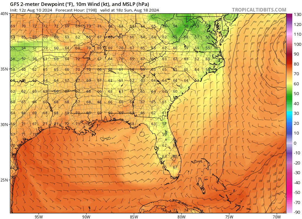
Dewpoints in the 50s and 60s for Florida next weekend!?! Future Ernesto may temporarily provide relief from a summer of excessive heat. 8-)

Image
0 likes   

jlauderdal
S2K Supporter
S2K Supporter
Posts: 7182
Joined: Wed May 19, 2004 5:46 am
Location: NE Fort Lauderdale
Contact:

Re: RE: Re: Florida Weather

#17655 Postby jlauderdal » Sat Aug 10, 2024 2:51 pm

gatorcane wrote:Dewpoints in the 50s and 60s for Florida next weekend!?! Future Ernesto may temporarily provide relief from a summer of excessive heat. 8-)

Image
Current DP 79, HX 110.....a 70 dp would feel great
0 likes   

User avatar
gatorcane
S2K Supporter
S2K Supporter
Posts: 23691
Age: 47
Joined: Sun Mar 13, 2005 3:54 pm
Location: Boca Raton, FL

Re: Florida Weather

#17656 Postby gatorcane » Sun Aug 11, 2024 8:15 am

The GFS is still showing some lower dewpoints and slightly lower temps across Florida next weekend with fresh NE wind flow due to the passing of future hurricane Ernesto well offshore and a deep trough of low pressure over the Great Lakes and Eastern CONUS. Low temps in the low to mid 70s for much of Florida with dewpoints in the mid 60s as far south as Miami. If that happens, despite it only being a subtle difference, will be a noticeable and a nice change.
0 likes   

User avatar
HurricaneBelle
S2K Supporter
S2K Supporter
Posts: 1179
Joined: Sun Aug 27, 2006 6:12 pm
Location: Clearwater, FL

Re: Florida Weather

#17657 Postby HurricaneBelle » Sun Aug 11, 2024 8:42 am

gatorcane wrote:The GFS is still showing some lower dewpoints and slightly lower temps across Florida next weekend with fresh NE wind flow due to the passing of future hurricane Ernesto well offshore and a deep trough of low pressure over the Great Lakes and Eastern CONUS. Low temps in the low to mid 70s for much of Florida with dewpoints in the mid 60s as far south as Miami. If that happens, despite it only being a subtle difference, will be a noticeable and a nice change.


It won't be open the windows time but at least my air conditioner won't have to work as hard.
0 likes   

psyclone
S2K Supporter
S2K Supporter
Posts: 4762
Joined: Wed Aug 24, 2005 9:04 pm
Location: palm harbor fl

Re: Florida Weather

#17658 Postby psyclone » Wed Aug 14, 2024 9:13 am

Cool dry air is certainly upstream. I have been up in Ohio and we have had multiple chilly nights with a recent low of 50. Incredible stuff for deep summer.
0 likes   

User avatar
MetroMike
Category 4
Category 4
Posts: 952
Joined: Sun Aug 29, 2004 8:13 pm
Location: Tampa Bay
Contact:

Re: Florida Weather

#17659 Postby MetroMike » Wed Aug 14, 2024 1:00 pm

Hurricane Debby really changed the pattern here on the west coast. Approaching the 2 week mark after it our precip chances are 20-30% at best. Normal for August here is 60%.
Hurricane Ernesto is only reinforcing that. Its not even that close to the coast for influencing the way it is.
Rainy season here normally lasts about 1 more month, getting frontal passages already?
0 likes   

User avatar
gatorcane
S2K Supporter
S2K Supporter
Posts: 23691
Age: 47
Joined: Sun Mar 13, 2005 3:54 pm
Location: Boca Raton, FL

Re: Florida Weather

#17660 Postby gatorcane » Sat Aug 17, 2024 7:36 pm

We had a nice hint of fall over the last couple of days in South Florida with breezy east to northeast winds, stratocumulus cloud decks rolling in off the Atlantic, and slightly lower dew points. It won't last long, but fall is around the corner.
1 likes   


Return to “USA & Caribbean Weather”

Who is online

Users browsing this forum: snownado, utpmg and 19 guests