ATL: ERNESTO - Post-Tropical - Discussion

Moderator: S2k Moderators

Message
Author
User avatar
ConvergenceZone
Category 5
Category 5
Posts: 5194
Joined: Fri Jul 29, 2005 1:40 am
Location: Northern California

Re: ATL: INVEST 98L - Discussion

#41 Postby ConvergenceZone » Sat Aug 10, 2024 5:26 pm

hipshot wrote:
ConvergenceZone wrote:So I wanted to check today to see if the forecast was still trending "out to sea" after the islands. The funny thing is, I had my answer before I clicked on this thread. Once I saw the thread only had 2 pages, I knew, "Yep, still out to sea" :) But of course I wanted to post this, so Is till clicked on the thread anyway lol. Page total tells ya everything :)


I don't know about OTS yet, still a long way to go. It still looks like it is going to hit the LA and GA to some extent so who know.

Well true never say never, but you have to go with the majority of models. Probably about an 80 to 90% chance out to sea (after the potential island impact that is) at this point. Please also remember, out to sea is completely normal with Atlantic forming storms. Not moving out to sea is actually abnormal.
1 likes   

hipshot
Category 2
Category 2
Posts: 591
Joined: Tue Jul 06, 2010 9:18 pm
Location: Dallas, Texas

Re: ATL: INVEST 98L - Discussion

#42 Postby hipshot » Sat Aug 10, 2024 5:41 pm

ConvergenceZone wrote:
hipshot wrote:
ConvergenceZone wrote:So I wanted to check today to see if the forecast was still trending "out to sea" after the islands. The funny thing is, I had my answer before I clicked on this thread. Once I saw the thread only had 2 pages, I knew, "Yep, still out to sea" :) But of course I wanted to post this, so Is till clicked on the thread anyway lol. Page total tells ya everything :)


I don't know about OTS yet, still a long way to go. It still looks like it is going to hit the LA and GA to some extent so who know.

Well true never say never, but you have to go with the majority of models. Probably about an 80 to 90% chance out to sea (after the potential island impact that is) at this point. Please also remember, out to sea is completely normal with Atlantic forming storms. Not moving out to sea is actually abnormal.


I'm certainly no expert but from following this site for many years, I don't trust the models this far out, just too many variables.
0 likes   

User avatar
ConvergenceZone
Category 5
Category 5
Posts: 5194
Joined: Fri Jul 29, 2005 1:40 am
Location: Northern California

Re: ATL: INVEST 98L - Discussion

#43 Postby ConvergenceZone » Sat Aug 10, 2024 5:44 pm

hipshot wrote:
ConvergenceZone wrote:
hipshot wrote:
I don't know about OTS yet, still a long way to go. It still looks like it is going to hit the LA and GA to some extent so who know.

Well true never say never, but you have to go with the majority of models. Probably about an 80 to 90% chance out to sea (after the potential island impact that is) at this point. Please also remember, out to sea is completely normal with Atlantic forming storms. Not moving out to sea is actually abnormal.

I'm certainly no expert but from following this site for many years, I don't trust the models this far out, just too many variables.


Yep there's always an "outside" chance for anything to happen.
1 likes   

User avatar
Teban54
Category 5
Category 5
Posts: 3168
Joined: Sat May 19, 2018 1:19 pm

Re: ATL: INVEST 98L - Discussion

#44 Postby Teban54 » Sat Aug 10, 2024 5:45 pm

Image
2 likes   

User avatar
Teban54
Category 5
Category 5
Posts: 3168
Joined: Sat May 19, 2018 1:19 pm

Re: ATL: INVEST 98L - Discussion

#45 Postby Teban54 » Sat Aug 10, 2024 5:58 pm

ConvergenceZone wrote:So I wanted to check today to see if the forecast was still trending "out to sea" after the islands. The funny thing is, I had my answer before I clicked on this thread. Once I saw the thread only had 2 pages, I knew, "Yep, still out to sea" :) But of course I wanted to post this, so Is till clicked on the thread anyway lol. Page total tells ya everything :)

I don't think that's a reliable indicator, simply because the forum can still get pretty quiet even if models show a CONUS landfall in New England or sometimes even NYC (as shown live with the 18z GFS). Florida (especially South Florida) is really the only place that makes forum activity explode; sometimes, even a modeled NC landfall gets less attention that it probably deserves.
4 likes   

User avatar
BlowHard
S2K Supporter
S2K Supporter
Posts: 48
Age: 66
Joined: Thu Aug 27, 2015 9:15 pm
Location: Vieques, PR/Swansea, MA
Contact:

Re: ATL: INVEST 98L - Discussion

#46 Postby BlowHard » Sat Aug 10, 2024 5:59 pm

ConvergenceZone wrote:
hipshot wrote:
ConvergenceZone wrote:So I wanted to check today to see if the forecast was still trending "out to sea" after the islands. The funny thing is, I had my answer before I clicked on this thread. Once I saw the thread only had 2 pages, I knew, "Yep, still out to sea" :) But of course I wanted to post this, so Is till clicked on the thread anyway lol. Page total tells ya everything :)


I don't know about OTS yet, still a long way to go. It still looks like it is going to hit the LA and GA to some extent so who know.

Well true never say never, but you have to go with the majority of models. Probably about an 80 to 90% chance out to sea (after the potential island impact that is) at this point. Please also remember, out to sea is completely normal with Atlantic forming storms. Not moving out to sea is actually abnormal.


OTS for Florida, maybe. Remind yourself that there are people on this board, and in the world, who are not in Florida. They might, for example, be in Puerto Rico.
8 likes   
I am not a professional and this is just my opinion. Always refer to the professionals for advice.

User avatar
ConvergenceZone
Category 5
Category 5
Posts: 5194
Joined: Fri Jul 29, 2005 1:40 am
Location: Northern California

Re: ATL: INVEST 98L - Discussion

#47 Postby ConvergenceZone » Sat Aug 10, 2024 6:07 pm

BlowHard wrote:
ConvergenceZone wrote:
hipshot wrote:
I don't know about OTS yet, still a long way to go. It still looks like it is going to hit the LA and GA to some extent so who know.

Well true never say never, but you have to go with the majority of models. Probably about an 80 to 90% chance out to sea (after the potential island impact that is) at this point. Please also remember, out to sea is completely normal with Atlantic forming storms. Not moving out to sea is actually abnormal.


OTS for Florida, maybe. Remind yourself that there are people on this board, and in the world, who are not in Florida. They might, for example, be in Puerto Rico.


which is why I said in my post "after the islands"
2 likes   

User avatar
cycloneye
Admin
Admin
Posts: 143867
Age: 68
Joined: Thu Oct 10, 2002 10:54 am
Location: San Juan, Puerto Rico

Re: ATL: INVEST 98L - Discussion

#48 Postby cycloneye » Sat Aug 10, 2024 6:29 pm

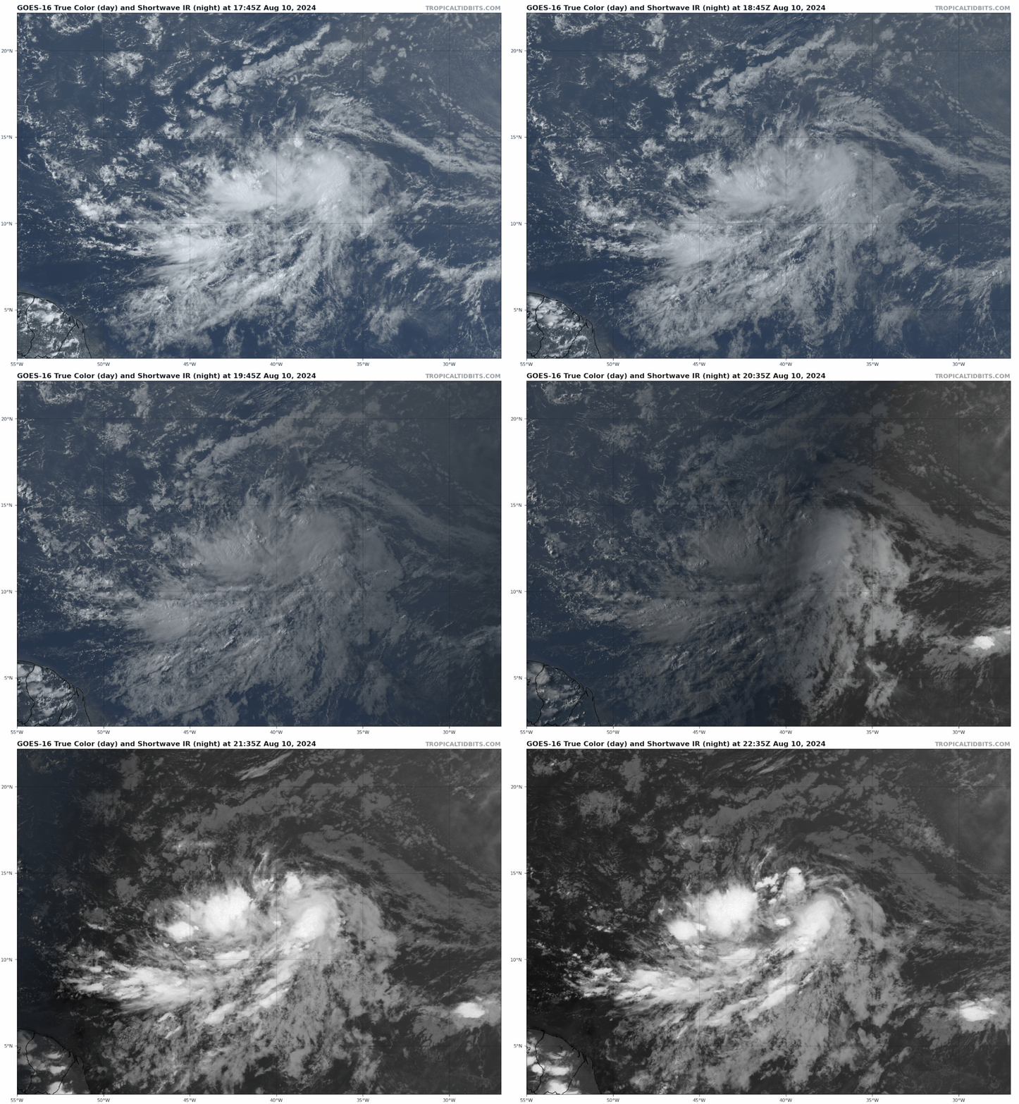
Slowly getting better organized. If you look closely, there is rotation where convection is popping up.

Image
2 likes   
Visit the Caribbean-Central America Weather Thread where you can find at first post web cams,radars
and observations from Caribbean basin members Click Here

User avatar
cycloneye
Admin
Admin
Posts: 143867
Age: 68
Joined: Thu Oct 10, 2002 10:54 am
Location: San Juan, Puerto Rico

Re: ATL: INVEST 98L - Discussion

#49 Postby cycloneye » Sat Aug 10, 2024 6:35 pm

Tropical Weather Outlook
NWS National Hurricane Center Miami FL
800 PM EDT Sat Aug 10 2024

For the North Atlantic...Caribbean Sea and the Gulf of Mexico:

1. Near the Lesser and Greater Antilles (AL98):
Shower and thunderstorm activity is showing some signs of
organization in association with a tropical wave located roughly
midway between the Cabo Verde Islands and the Lesser Antilles.
Environmental conditions appear conducive for gradual development of
this system during the next few days while it moves westward to
west-northwestward at 15 to 20 mph across the central tropical
Atlantic. A tropical depression is likely to form by the early to
middle part of next week while the system approaches and then moves
near or over the Lesser Antilles, and interests there should monitor
the progress of this system. Then, the system is forecast to move
generally west-northwestward and could approach portions of the
Greater Antilles by the middle to latter part of next week.
* Formation chance through 48 hours...medium...50 percent.
* Formation chance through 7 days...high...90 percent.


Forecaster Papin
1 likes   
Visit the Caribbean-Central America Weather Thread where you can find at first post web cams,radars
and observations from Caribbean basin members Click Here

hipshot
Category 2
Category 2
Posts: 591
Joined: Tue Jul 06, 2010 9:18 pm
Location: Dallas, Texas

Re: ATL: INVEST 98L - Discussion

#50 Postby hipshot » Sat Aug 10, 2024 7:02 pm

cycloneye wrote:Slowly getting better organized. If you look closely, there is rotation where convection is popping up.

https://i.imgur.com/ZJXLRCO.gif


I looked really hard at the low level circulation and I can't see it....yet.
0 likes   

tolakram
Admin
Admin
Posts: 19990
Age: 61
Joined: Sun Aug 27, 2006 8:23 pm
Location: Florence, KY (name is Mark)

Re: ATL: INVEST 98L - Discussion

#51 Postby tolakram » Sat Aug 10, 2024 7:16 pm

ConvergenceZone wrote:So I wanted to check today to see if the forecast was still trending "out to sea" after the islands. The funny thing is, I had my answer before I clicked on this thread. Once I saw the thread only had 2 pages, I knew, "Yep, still out to sea" :) But of course I wanted to post this, so Is till clicked on the thread anyway lol. Page total tells ya everything :)


Congrats, you made it this far into the season before annoying me this year. :lol:
12 likes   
M a r k
- - - - -
Join us in chat: Storm2K Chatroom Invite. Android and IOS apps also available.

The posts in this forum are NOT official forecasts and should not be used as such. Posts are NOT endorsed by any professional institution or STORM2K.org. For official information and forecasts, please refer to NHC and NWS products.

User avatar
Category5Kaiju
Category 5
Category 5
Posts: 4051
Joined: Thu Dec 24, 2020 12:45 pm
Location: Seattle

Re: ATL: INVEST 98L - Discussion

#52 Postby Category5Kaiju » Sat Aug 10, 2024 7:30 pm

ConvergenceZone wrote:So I wanted to check today to see if the forecast was still trending "out to sea" after the islands. The funny thing is, I had my answer before I clicked on this thread. Once I saw the thread only had 2 pages, I knew, "Yep, still out to sea" :) But of course I wanted to post this, so Is till clicked on the thread anyway lol. Page total tells ya everything :)


Wait until you find out about the Hurricane Otis discussion history.

Linking page number with certainty that a storm is going OTS, let alone even before it forms, is a very faulty line of thinking :lol:
Last edited by Category5Kaiju on Sat Aug 10, 2024 7:35 pm, edited 1 time in total.
2 likes   
Unless explicitly stated, all info in my posts is based on my own opinions and observations. Tropical storms and hurricanes can be extremely dangerous. Do not think you can beat Mother Nature. Refer to an accredited weather research agency or meteorologist if you need to make serious decisions regarding an approaching storm.

User avatar
ConvergenceZone
Category 5
Category 5
Posts: 5194
Joined: Fri Jul 29, 2005 1:40 am
Location: Northern California

Re: ATL: INVEST 98L - Discussion

#53 Postby ConvergenceZone » Sat Aug 10, 2024 7:33 pm

tolakram wrote:
ConvergenceZone wrote:So I wanted to check today to see if the forecast was still trending "out to sea" after the islands. The funny thing is, I had my answer before I clicked on this thread. Once I saw the thread only had 2 pages, I knew, "Yep, still out to sea" :) But of course I wanted to post this, so Is till clicked on the thread anyway lol. Page total tells ya everything :)


Congrats, you made it this far into the season before annoying me this year. :lol:


lmao Yea I've got annoyed on here by many posters as well, so I do understand :)
But it's true though. I remember with Debbie, or maybe it was Beryl I woke up and saw like a 20 page increase, and I was thinking oh crap, that's not a good sign at all! and yep, it wasn't.
1 likes   

User avatar
ConvergenceZone
Category 5
Category 5
Posts: 5194
Joined: Fri Jul 29, 2005 1:40 am
Location: Northern California

Re: ATL: INVEST 98L - Discussion

#54 Postby ConvergenceZone » Sat Aug 10, 2024 7:43 pm

Category5Kaiju wrote:
ConvergenceZone wrote:So I wanted to check today to see if the forecast was still trending "out to sea" after the islands. The funny thing is, I had my answer before I clicked on this thread. Once I saw the thread only had 2 pages, I knew, "Yep, still out to sea" :) But of course I wanted to post this, so Is till clicked on the thread anyway lol. Page total tells ya everything :)


Wait until you find out about the Hurricane Otis discussion history.

Linking page number with certainty that a storm is going OTS, let alone even before it forms, is a very faulty line of thinking :lol:


Yea there are exceptions to that rule for sure, but I kind of just have fun with it and make it a guessing same and see if I'm write or not before opening the thread..... It's just fun to do. It's kind of lik
I get bored sometimes so I like to have fun :). Of course it's not fun when you see the opposite occur when the posts rapidly accelerate after some ominous news on a storm. When I was a kid I was diagnosed with autism and having trouble with communication is one of my symptoms that I never got a handle with, so I like to spend alot of time on here. Such an amazing group of people here.
3 likes   

bob rulz
Category 5
Category 5
Posts: 1703
Age: 35
Joined: Sat Jan 28, 2006 7:30 pm
Location: Salt Lake City, Utah

Re: ATL: INVEST 98L - Discussion

#55 Postby bob rulz » Sat Aug 10, 2024 8:34 pm

I think saying there's an 80%-90% chance that it will go "out to sea" (not hit the US) at this point is far too premature. Way too many variables. I think we should all know that models are usually going to be wrong to some extent that far out.

Beef Stew wrote:
ScottNAtlanta wrote:
Beef Stew wrote:
I agree fully. As of now, it’s reminding me of similar tracks we’ve seen that scrape through the northern Caribbean (greater Antilles/southern Bahamas/Turks and Caicos/etc) and then recurve outwards or go on to impact Atlantic Canada. That being said it’s still early August- there’s a lot that can happen as this storm evolves that could potentially result in it being further west, and I’m not yet entirely sold
on troughing saving the day for the eastern seaboard.

One thing that really stands out to me- if I’m not mistaken, the Southeast US coast hasn’t been hit by a major hurricane in nearly 20 years- the last was Jeanne in 2004. If we look outside of Florida, the drought is even longer- Fran (North Carolina) was the last non-FL landfall in 1996. South Carolina hasn’t seen one since Hugo in 1989, and Georgia- well, Georgia’s dodged the bullet time and time again and hasn’t had a major landfall in a whopping 126 years, since the Georgia Hurricane of 1898.

I’m certainly not saying Ernesto will be the one to break the favored climatological path of a recurve and snap any of these droughts- but it’s going to happen one day, and with this season appearing to have a more western component to it thus far, I’m not jumping to any conclusions about any storms until things are much more solidified.

Was Florence a major when it went into NC? I forgot it weakened before it went in


Florence was originally forecast to make landfall as a 140 mph category 4 in NC in the early NHC advisories. It was one of the most bullish NHC outputs I remember ever reading for a landfall that far in advanced. As fate would have it, however, Florence ended up getting stuck in a nearly endless cycle of EWRC’s and would encounter far more dry air and shear towards the coast than originally anticipated, and “only” made landfall as a category 1 when all said and done. However, the rainfall and surge brought by Florence much more resembled that of a major hurricane than a category 1 due to her large wind field and slowing to a crawl near landfall.


This is a good example of why I don't love the "major hurricane" designation. Florence and Sandy, for example, are hurricanes that I think most people would consider "major" in terms of impact, but they don't count as "major hurricane" landfalls because they weren't tropical cat 3+ hurricanes at landfall.
4 likes   

User avatar
skyline385
Category 5
Category 5
Posts: 2728
Age: 34
Joined: Wed Aug 26, 2020 11:15 pm
Location: Houston TX

Re: ATL: INVEST 98L - Discussion

#56 Postby skyline385 » Sat Aug 10, 2024 8:41 pm

bob rulz wrote:I think saying there's an 80%-90% chance that it will go "out to sea" (not hit the US) at this point is far too premature. Way too many variables. I think we should all know that models are usually going to be wrong to some extent that far out.

Beef Stew wrote:
ScottNAtlanta wrote:Was Florence a major when it went into NC? I forgot it weakened before it went in


Florence was originally forecast to make landfall as a 140 mph category 4 in NC in the early NHC advisories. It was one of the most bullish NHC outputs I remember ever reading for a landfall that far in advanced. As fate would have it, however, Florence ended up getting stuck in a nearly endless cycle of EWRC’s and would encounter far more dry air and shear towards the coast than originally anticipated, and “only” made landfall as a category 1 when all said and done. However, the rainfall and surge brought by Florence much more resembled that of a major hurricane than a category 1 due to her large wind field and slowing to a crawl near landfall.


This is a good example of why I don't love the "major hurricane" designation. Florence and Sandy, for example, are hurricanes that I think most people would consider "major" in terms of impact, but they don't count as "major hurricane" landfalls because they weren't tropical cat 3+ hurricanes at landfall.


The two hurricanes you mentioned are extreme and rare anomalies and not the norm. Broadly speaking, a major hurricane generally will have more impact than a C1/2 and hence the designation exists in the interest of public safety and communication. Regular folks generally don't understand hurricane categories a lot but a major hurricane however will feel more impactful during communications.
1 likes   

Craters
Category 1
Category 1
Posts: 421
Joined: Sat Aug 24, 2013 2:34 pm
Location: Alvin, TX (south of Houston)

Re: ATL: INVEST 98L - Discussion

#57 Postby Craters » Sat Aug 10, 2024 8:51 pm

skyline385 wrote:
bob rulz wrote:I think saying there's an 80%-90% chance that it will go "out to sea" (not hit the US) at this point is far too premature. Way too many variables. I think we should all know that models are usually going to be wrong to some extent that far out.

Beef Stew wrote:
Florence was originally forecast to make landfall as a 140 mph category 4 in NC in the early NHC advisories. It was one of the most bullish NHC outputs I remember ever reading for a landfall that far in advanced. As fate would have it, however, Florence ended up getting stuck in a nearly endless cycle of EWRC’s and would encounter far more dry air and shear towards the coast than originally anticipated, and “only” made landfall as a category 1 when all said and done. However, the rainfall and surge brought by Florence much more resembled that of a major hurricane than a category 1 due to her large wind field and slowing to a crawl near landfall.


This is a good example of why I don't love the "major hurricane" designation. Florence and Sandy, for example, are hurricanes that I think most people would consider "major" in terms of impact, but they don't count as "major hurricane" landfalls because they weren't tropical cat 3+ hurricanes at landfall.


The two hurricanes you mentioned are extreme and rare anomalies and not the norm. Broadly speaking, a major hurricane generally will have more impact than a C1/2 and hence the designation exists in the interest of public safety and communication. Regular folks generally don't understand hurricane categories a lot but a major hurricane however will feel more impactful during communications.

I would nominate "Category 2" Ike as another major anomaly.
0 likes   
Nothing that I post here should ever be treated as a forecast or anything resembling one. Please check with your local NWS office or the NHC for forecasts, watches, and warnings.

User avatar
ConvergenceZone
Category 5
Category 5
Posts: 5194
Joined: Fri Jul 29, 2005 1:40 am
Location: Northern California

Re: ATL: INVEST 98L - Discussion

#58 Postby ConvergenceZone » Sat Aug 10, 2024 8:52 pm

bob rulz wrote:I think saying there's an 80%-90% chance that it will go "out to sea" (not hit the US) at this point is far too premature. Way too many variables. I think we should all know that models are usually going to be wrong to some extent that far out.


We shall see :)
0 likes   

Craters
Category 1
Category 1
Posts: 421
Joined: Sat Aug 24, 2013 2:34 pm
Location: Alvin, TX (south of Houston)

Re: ATL: INVEST 98L - Discussion

#59 Postby Craters » Sat Aug 10, 2024 8:54 pm

hipshot wrote:
ConvergenceZone wrote:So I wanted to check today to see if the forecast was still trending "out to sea" after the islands. The funny thing is, I had my answer before I clicked on this thread. Once I saw the thread only had 2 pages, I knew, "Yep, still out to sea" :) But of course I wanted to post this, so Is till clicked on the thread anyway lol. Page total tells ya everything :)


I don't know about OTS yet, still a long way to go. It still looks like it is going to hit the LA and GA to some extent so who know.

Geez. I must be tired. I actually spent a few seconds wondering "Now, how in the world could it hit Louisiana and Georgia without going through MIssissippi, Alabama, or Florida?"

Duh.
2 likes   
Nothing that I post here should ever be treated as a forecast or anything resembling one. Please check with your local NWS office or the NHC for forecasts, watches, and warnings.

User avatar
ScottNAtlanta
Category 5
Category 5
Posts: 2360
Joined: Sat May 25, 2013 3:11 pm
Location: Atlanta, GA

Re: ATL: INVEST 98L - Discussion

#60 Postby ScottNAtlanta » Sat Aug 10, 2024 9:03 pm

I still don't think the models are handling the Rex Block over Canada very well.
A Rex block is a stationary high pressure system with a trapped low underneath. It keeps the trough from being able to move out and it ends up cut off. In this case we could be looking at a trough split that ends up leaving a piece behind that gets trapped. Models don't handle this well because steering currents break down. A good example of this scenario is Hurricane Sandy when it was pulled in by the cut off low.
2 likes   
The posts in this forum are NOT official forecast and should not be used as such. They are just the opinion of the poster and may or may not be backed by sound meteorological data. They are NOT endorsed by any professional institution or storm2k.org. For official information, please refer to the NHC and NWS products.


Return to “2024”

Who is online

Users browsing this forum: No registered users and 36 guests