ATL: ERNESTO - Models

Moderator: S2k Moderators

Message
Author
User avatar
'CaneFreak
Category 5
Category 5
Posts: 1486
Joined: Mon Jun 05, 2006 10:50 am
Location: New Bern, NC

Re: ATL: INVEST 98L - Models

#81 Postby 'CaneFreak » Sat Aug 10, 2024 10:56 pm

LarryWx wrote:0Z ICON: quite a bit closer to US E coast vs 12Z run going N along 70W


Yeah and did you see that shortwave over the Great Lakes? Looks like it was not moving much at the end of the run. Maybe a trough capture of a TC scenario if we had a run that went beyond 180 hrs? Also notice at the end of the run how much farther east that trough in the North Atlantic is compared to 12Z? Things that make you go hmmmmm
0 likes   

User avatar
skyline385
Category 5
Category 5
Posts: 2728
Age: 34
Joined: Wed Aug 26, 2020 11:15 pm
Location: Houston TX

Re: ATL: INVEST 98L - Models

#82 Postby skyline385 » Sat Aug 10, 2024 11:03 pm

0Z ICON shifts south while 0Z GFS shifts north, both seem to be meeting in the middle and this probably wont be good for PR if current trends continue

Image
0 likes   

Tekken_Guy
Tropical Storm
Tropical Storm
Posts: 135
Joined: Fri Sep 01, 2017 8:08 pm

Re: ATL: INVEST 98L - Models

#83 Postby Tekken_Guy » Sat Aug 10, 2024 11:08 pm

skyline385 wrote:0Z ICON shifts south while 0Z GFS shifts north, both seem to be meeting in the middle and this probably wont be good for PR if current trends continue

https://i.imgur.com/EBDqPJ3.png


That’s a good sign for the CONUS, since the models that put it at risk had the storm hit Hispaniola instead.
0 likes   

User avatar
'CaneFreak
Category 5
Category 5
Posts: 1486
Joined: Mon Jun 05, 2006 10:50 am
Location: New Bern, NC

Re: ATL: INVEST 98L - Models

#84 Postby 'CaneFreak » Sat Aug 10, 2024 11:26 pm

'CaneFreak wrote:
LarryWx wrote:0Z ICON: quite a bit closer to US E coast vs 12Z run going N along 70W


Yeah and did you see that shortwave over the Great Lakes? Looks like it was not moving much at the end of the run. Maybe a trough capture of a TC scenario if we had a run that went beyond 180 hrs? Also notice at the end of the run how much farther east that trough in the North Atlantic is compared to 12Z? Things that make you go hmmmmm


Wow. It’s like instant replay. The 0Z GFS and 0Z ICON look very similar through 180 hours with that trough over the Great Lakes. This should be interesting.
0 likes   

User avatar
Xyls
Tropical Storm
Tropical Storm
Posts: 162
Joined: Thu Sep 07, 2023 3:48 pm
Location: New Brunswick, Canada

Re: ATL: INVEST 98L - Models

#85 Postby Xyls » Sat Aug 10, 2024 11:41 pm

Watching this from Atlantic Canada and wondering if this could be a redux of Fiona. Seems too soon to say at the moment but the threat is there that it does a Puerto Rico strike and then beelines at Atlantic Canada based on some of these models.
0 likes   
Not a professional meteorologist. Please refer to NHC forecasts for official information/advice relating to tropical systems.

User avatar
'CaneFreak
Category 5
Category 5
Posts: 1486
Joined: Mon Jun 05, 2006 10:50 am
Location: New Bern, NC

Re: ATL: INVEST 98L - Models

#86 Postby 'CaneFreak » Sat Aug 10, 2024 11:42 pm

OK so looking at the GFS, if this hits PR and goes due north after departing from PR, it will be a subsequent threat to Bermuda and maybe Newfoundland. If it goes southwest of PR and maybe grazes Hispaniola moving northwest, it will stand a higher chance of impacting the CONUS in this setup. The latest GFS was very very close to being a trough capture. Had the storm been a bit farther west like the ICON showed, it would have gotten wrapped right into the Mid-Atlantic and Northeast. This one is going to be a nailbiter for sure.
0 likes   

IsabelaWeather
Category 1
Category 1
Posts: 287
Age: 35
Joined: Tue Jul 07, 2020 7:29 am
Location: Isabela, Puerto Rico

Re: ATL: INVEST 98L - Models

#87 Postby IsabelaWeather » Sat Aug 10, 2024 11:46 pm

Well, that was an interesting run from the 00z GFS, to say the least. Verbatim I'd have an eye party at my house.
0 likes   

Tekken_Guy
Tropical Storm
Tropical Storm
Posts: 135
Joined: Fri Sep 01, 2017 8:08 pm

Re: ATL: INVEST 98L - Models

#88 Postby Tekken_Guy » Sat Aug 10, 2024 11:57 pm

'CaneFreak wrote:OK so looking at the GFS, if this hits PR and goes due north after departing from PR, it will be a subsequent threat to Bermuda and maybe Newfoundland. If it goes southwest of PR and maybe grazes Hispaniola moving northwest, it will stand a higher chance of impacting the CONUS in this setup. The latest GFS was very very close to being a trough capture. Had the storm been a bit farther west like the ICON showed, it would have gotten wrapped right into the Mid-Atlantic and Northeast. This one is going to be a nailbiter for sure.


Not really. The ICON ended with the storm too far to the east to pose a serious threat to the US, outside of maybe New England via the “left hook” scenario we saw in earlier GFSs today.
0 likes   

User avatar
aspen
Category 5
Category 5
Posts: 8812
Joined: Sat Oct 12, 2019 7:10 pm
Location: Connecticut, USA

Re: ATL: INVEST 98L - Models

#89 Postby aspen » Sun Aug 11, 2024 5:26 am

Seems like there’s a greater consensus this morning that the CONUS should be safe after 98L passes the Caribbean. Bermuda, on the other hand, could get whacked.

Track consensus seems quite similar to Earl ‘22.
1 likes   
Irene '11 Sandy '12 Hermine '16 5/15/2018 Derecho Fay '20 Isaias '20 Elsa '21 Henri '21 Ida '21

I am only a meteorology enthusiast who knows a decent amount about tropical cyclones. Look to the professional mets, the NHC, or your local weather office for the best information.

mantis83
Tropical Storm
Tropical Storm
Posts: 198
Joined: Fri Dec 05, 2003 4:47 pm

Re: ATL: INVEST 98L - Models

#90 Postby mantis83 » Sun Aug 11, 2024 6:15 am

6z gfs more in line with the euro now in passing north and east of puerto rico.....
2 likes   

User avatar
'CaneFreak
Category 5
Category 5
Posts: 1486
Joined: Mon Jun 05, 2006 10:50 am
Location: New Bern, NC

Re: ATL: INVEST 98L - Models

#91 Postby 'CaneFreak » Sun Aug 11, 2024 6:41 am

Tekken_Guy wrote:
'CaneFreak wrote:OK so looking at the GFS, if this hits PR and goes due north after departing from PR, it will be a subsequent threat to Bermuda and maybe Newfoundland. If it goes southwest of PR and maybe grazes Hispaniola moving northwest, it will stand a higher chance of impacting the CONUS in this setup. The latest GFS was very very close to being a trough capture. Had the storm been a bit farther west like the ICON showed, it would have gotten wrapped right into the Mid-Atlantic and Northeast. This one is going to be a nailbiter for sure.


Not really. The ICON ended with the storm too far to the east to pose a serious threat to the US, outside of maybe New England via the “left hook” scenario we saw in earlier GFSs today.


Yeah the Mid-Atlantic and Northeast is what I meant. Sorry I wasn’t specific. Looks like it is consolidating to the north today despite what it looked like last night so it is increasingly likely to be a miss for many.
2 likes   

User avatar
aspen
Category 5
Category 5
Posts: 8812
Joined: Sat Oct 12, 2019 7:10 pm
Location: Connecticut, USA

Re: ATL: INVEST 98L - Models

#92 Postby aspen » Sun Aug 11, 2024 7:17 am

6z HWRF shows genesis tomorrow morning, even though it initializes the wave as pretty anemic.

It also continues to show a small core with tons of outer bands/eyewalls.
1 likes   
Irene '11 Sandy '12 Hermine '16 5/15/2018 Derecho Fay '20 Isaias '20 Elsa '21 Henri '21 Ida '21

I am only a meteorology enthusiast who knows a decent amount about tropical cyclones. Look to the professional mets, the NHC, or your local weather office for the best information.

User avatar
gatorcane
S2K Supporter
S2K Supporter
Posts: 23689
Age: 47
Joined: Sun Mar 13, 2005 3:54 pm
Location: Boca Raton, FL

Re: ATL: INVEST 98L - Models

#93 Postby gatorcane » Sun Aug 11, 2024 7:20 am

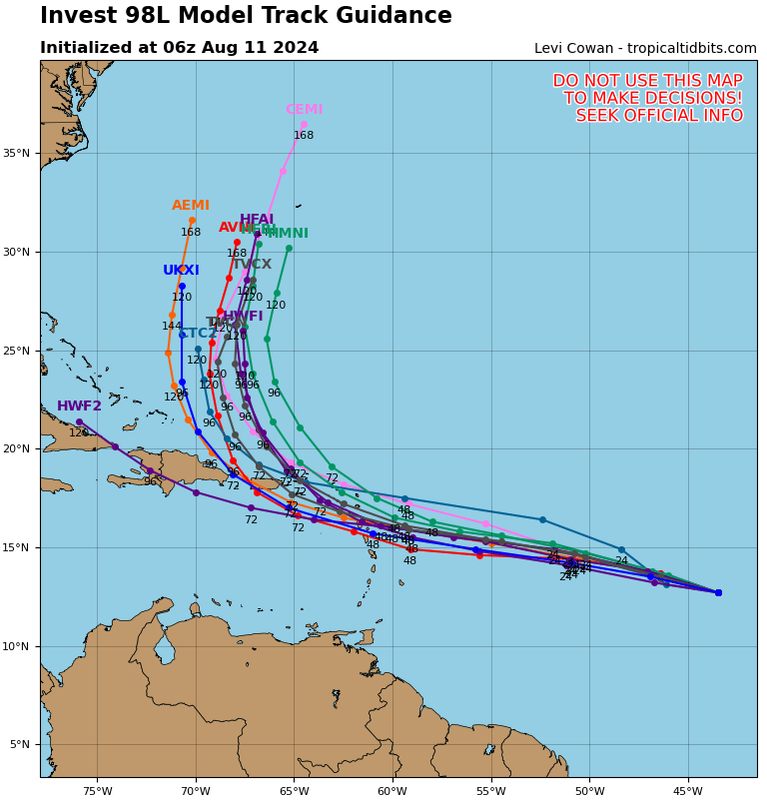
06Z guidance. All models except the HWRF (outlier), turn it north after Puerto Rico:
Image
1 likes   

User avatar
Hypercane_Kyle
Category 5
Category 5
Posts: 3344
Joined: Sat Mar 07, 2015 7:58 pm
Location: Cape Canaveral, FL

Re: ATL: INVEST 98L - Models

#94 Postby Hypercane_Kyle » Sun Aug 11, 2024 7:24 am

Might get lucky here as far as land impacts go and have it miss the islands entirely.
4 likes   
My posts are my own personal opinion, defer to the National Hurricane Center (NHC) and other NOAA products for decision making during hurricane season.

KPILM
Tropical Wave
Tropical Wave
Posts: 6
Joined: Wed Aug 07, 2024 6:57 am

Re: ATL: INVEST 98L - Models

#95 Postby KPILM » Sun Aug 11, 2024 7:29 am

Okay, don't laugh at this question, I'm just a clueless scrub, but I've been watching a lot of videos recently where the prediction is early Fall weather and colder than average temps across the US (the Farmer's Almanac forecast also predicts earlier and colder temps). If these predictions come to pass, how exactly would it effect future storms for the rest of the season?
1 likes   

BobHarlem
Category 5
Category 5
Posts: 2034
Joined: Thu Oct 20, 2005 6:11 pm

Re: ATL: INVEST 98L - Models

#96 Postby BobHarlem » Sun Aug 11, 2024 7:54 am

12z Tvcn consensus is now every so slightly to the right (north) of the islands and just barely east of Bermuda. Odds of the old fush spinner increasing if those trends right continue and especially if it strengthens early.
Image
0 likes   

User avatar
aspen
Category 5
Category 5
Posts: 8812
Joined: Sat Oct 12, 2019 7:10 pm
Location: Connecticut, USA

Re: ATL: INVEST 98L - Models

#97 Postby aspen » Sun Aug 11, 2024 8:16 am

GFS and HWRF show a significant improvement in 98L’s upper-level setup starting on Wednesday, with an excellent anticyclone parked over the system from roughly midday Wednesday to late Thursday. If the system has a good structure by then, we’d need to watch out for RI, especially since this’ll be when it’s passing through the NE Lesser Antilles.
1 likes   
Irene '11 Sandy '12 Hermine '16 5/15/2018 Derecho Fay '20 Isaias '20 Elsa '21 Henri '21 Ida '21

I am only a meteorology enthusiast who knows a decent amount about tropical cyclones. Look to the professional mets, the NHC, or your local weather office for the best information.

tolakram
Admin
Admin
Posts: 19989
Age: 61
Joined: Sun Aug 27, 2006 8:23 pm
Location: Florence, KY (name is Mark)

Re: ATL: INVEST 98L - Models

#98 Postby tolakram » Sun Aug 11, 2024 9:56 am

KPILM wrote:Okay, don't laugh at this question, I'm just a clueless scrub, but I've been watching a lot of videos recently where the prediction is early Fall weather and colder than average temps across the US (the Farmer's Almanac forecast also predicts earlier and colder temps). If these predictions come to pass, how exactly would it effect future storms for the rest of the season?


Farmers Almanac is fun but also junk. In other words you're asking a question similar to how would trees look if the sky turned lime green tomorrow. There is no value in the result. Makes for good Youtube videos and engagement, but not much else.

Cold fronts making it into the gulf and Atlantic are responsible for spinning up a lot of later season storms. Fall arrives every year, pretty close to the same time. :lol: If you've been around a while you'll get used to the eb and flow of the typical seasonal nonsense. Someone will predict that a cold front will end the season early. If that season does in fact end early they relish in being 'correct', and if it doesn't they will go silent. Bad science is easy and gets the views!

If your source has a verifiable track record then we have something to discuss, at least, but not here. We have a seasonal indicator thread for that.
4 likes   
M a r k
- - - - -
Join us in chat: Storm2K Chatroom Invite. Android and IOS apps also available.

The posts in this forum are NOT official forecasts and should not be used as such. Posts are NOT endorsed by any professional institution or STORM2K.org. For official information and forecasts, please refer to NHC and NWS products.

LarryWx
Category 5
Category 5
Posts: 6246
Joined: Sun Sep 07, 2003 2:04 pm
Location: GA

Re: ATL: INVEST 98L - Models

#99 Postby LarryWx » Sun Aug 11, 2024 11:02 am

12Z CMC: track shifted W to eastern PR/Virgin Islands. Just yesterday it was a few hundred miles away at closest approach.
0 likes   
Personal Forecast Disclaimer:
The posts in this forum are NOT official forecasts and should not be used as such. They are just the opinion of the poster and may or may not be backed by sound meteorological data. They are NOT endorsed by any professional institution or storm2k.org. For official information, please refer to the NHC and NWS products.

LarryWx
Category 5
Category 5
Posts: 6246
Joined: Sun Sep 07, 2003 2:04 pm
Location: GA

Re: ATL: INVEST 98L - Models

#100 Postby LarryWx » Sun Aug 11, 2024 11:21 am

12Z UKMET: goes NW ~150 miles W of Bermuda

NEW TROPICAL CYCLONE FORECAST TO DEVELOP AFTER 84 HOURS
FORECAST POSITION AT T+ 84 : 20.5N 69.4W

LEAD CENTRAL MAXIMUM WIND
VERIFYING TIME TIME POSITION PRESSURE (MB) SPEED (KNOTS)
-------------- ---- -------- ------------- -------------
0000UTC 15.08.2024 84 20.5N 69.4W 1008 32
1200UTC 15.08.2024 96 22.9N 70.2W 1008 42
0000UTC 16.08.2024 108 25.0N 70.1W 1005 46
1200UTC 16.08.2024 120 27.0N 68.9W 1002 50
0000UTC 17.08.2024 132 28.5N 67.5W 999 50
1200UTC 17.08.2024 144 30.7N 66.8W 994 47
0000UTC 18.08.2024 156 32.2N 67.1W 990 46
1200UTC 18.08.2024 168 33.7N 68.5W 991 47
0 likes   
Personal Forecast Disclaimer:
The posts in this forum are NOT official forecasts and should not be used as such. They are just the opinion of the poster and may or may not be backed by sound meteorological data. They are NOT endorsed by any professional institution or storm2k.org. For official information, please refer to the NHC and NWS products.


Return to “2024”

Who is online

Users browsing this forum: No registered users and 15 guests