
ATL: ERNESTO - Models
Moderator: S2k Moderators
Re: ATL: FIVE - Models
Split storm with 0z gfs
Last edited by BobHarlem on Sun Aug 11, 2024 11:08 pm, edited 1 time in total.
1 likes
-
Stratton23
- Category 5

- Posts: 3574
- Joined: Fri Jul 21, 2023 10:59 pm
- Location: Katy, Tx
Re: ATL: FIVE - Models
0Z ICON way west vs earlier runs and other models! Well W of Bermuda and on a heading not far from NE US!
0 likes
Personal Forecast Disclaimer:
The posts in this forum are NOT official forecasts and should not be used as such. They are just the opinion of the poster and may or may not be backed by sound meteorological data. They are NOT endorsed by any professional institution or storm2k.org. For official information, please refer to the NHC and NWS products.
The posts in this forum are NOT official forecasts and should not be used as such. They are just the opinion of the poster and may or may not be backed by sound meteorological data. They are NOT endorsed by any professional institution or storm2k.org. For official information, please refer to the NHC and NWS products.
Re: ATL: FIVE - Models
0Z UKMET: similar to 12Z run. This goes W of Bermuda while moving NNE
NEW TROPICAL CYCLONE FORECAST TO DEVELOP AFTER 84 HOURS
FORECAST POSITION AT T+ 84 : 22.7N 71.1W
LEAD CENTRAL MAXIMUM WIND
VERIFYING TIME TIME POSITION PRESSURE (MB) SPEED (KNOTS)
-------------- ---- -------- ------------- -------------
1200UTC 15.08.2024 84 22.7N 71.1W 1006 43
0000UTC 16.08.2024 96 24.1N 71.2W 1004 47
1200UTC 16.08.2024 108 26.1N 70.1W 1000 48
0000UTC 17.08.2024 120 27.7N 69.8W 998 43
1200UTC 17.08.2024 132 28.8N 69.9W 997 50
0000UTC 18.08.2024 144 30.2N 70.1W 995 52
1200UTC 18.08.2024 156 32.8N 69.3W 993 50
0000UTC 19.08.2024 168 36.4N 68.2W 982 63
0 likes
Personal Forecast Disclaimer:
The posts in this forum are NOT official forecasts and should not be used as such. They are just the opinion of the poster and may or may not be backed by sound meteorological data. They are NOT endorsed by any professional institution or storm2k.org. For official information, please refer to the NHC and NWS products.
The posts in this forum are NOT official forecasts and should not be used as such. They are just the opinion of the poster and may or may not be backed by sound meteorological data. They are NOT endorsed by any professional institution or storm2k.org. For official information, please refer to the NHC and NWS products.


Re: ATL: FIVE - Models
Yeah, big west shift by both ICON and GFS in the 00z runs. I would consider the ICON uncomfortably close to land. It does reduce my confidence a bit for safe recurve. Though we will have to see if it's just windshield wipers or the start of a trend.LarryWx wrote:0Z ICON way west vs earlier runs and other models! Well W of Bermuda and on a heading not far from NE US!

1 likes
-
Tekken_Guy
- Tropical Storm

- Posts: 150
- Joined: Fri Sep 01, 2017 8:08 pm
Re: RE: Re: ATL: FIVE - Models
Woofde wrote:Yeah, big west shift by both ICON and GFS in the 00z runs. I would consider the ICON uncomfortably close to land. It does reduce my confidence a bit for safe recurve. Though we will have to see if it's just windshield wipers or the start of a trend.https://uploads.tapatalk-cdn.com/20240812/30680dbaaed6ef5648d835241fe5405a.jpgLarryWx wrote:0Z ICON way west vs earlier runs and other models! Well W of Bermuda and on a heading not far from NE US!
No, the GFS doesn’t shift the story west that much.
0 likes
Re: ATL: FIVE - Models
I should clarify I was talking about where it is in respect to the Northeast. That's a solid 300 mile jump west from 18z to 0z.Tekken_Guy wrote:Woofde wrote:Yeah, big west shift by both ICON and GFS in the 00z runs. I would consider the ICON uncomfortably close to land. It does reduce my confidence a bit for safe recurve. Though we will have to see if it's just windshield wipers or the start of a trend.https://uploads.tapatalk-cdn.com/20240812/30680dbaaed6ef5648d835241fe5405a.jpgLarryWx wrote:0Z ICON way west vs earlier runs and other models! Well W of Bermuda and on a heading not far from NE US!
No, the GFS doesn’t shift the story west that much.


0 likes
-
cheezyWXguy

- Category 5
- Posts: 6282
- Joined: Mon Feb 13, 2006 12:29 am
- Location: Dallas, TX
Re: ATL: FIVE - Models
That 0z run is truly bizarre. Having a second storm form off the same wave and book it northward ahead of the first one seems to open the weakness more and lead to a further east trajectory than it would have if it were just a single storm. It’s also weird to see it basically plow through a 500mb ridge and escape northeast. To me, this screams bogus, but I’d rather hear from someone more knowledgeable on this.
0 likes
-
skyline385

- Category 5
- Posts: 2728
- Age: 35
- Joined: Wed Aug 26, 2020 11:15 pm
- Location: Houston TX
Re: ATL: FIVE - Models
The 2 system run from GFS is weird as hell and I doubt we get a second system out of 98L but it does seem increasingly likely that it will remain broad for longer than expected. CMC has also trended towards a broader vortex near PR in last 4 runs and ICON pretty much develops it only after crossing PR/DR.
3 likes
Re: ATL: FIVE - Models
0Z Euro: weak at PR but much stronger with cat 2 H with center just E of Bermuda followed by a miss of Canada
0 likes
Personal Forecast Disclaimer:
The posts in this forum are NOT official forecasts and should not be used as such. They are just the opinion of the poster and may or may not be backed by sound meteorological data. They are NOT endorsed by any professional institution or storm2k.org. For official information, please refer to the NHC and NWS products.
The posts in this forum are NOT official forecasts and should not be used as such. They are just the opinion of the poster and may or may not be backed by sound meteorological data. They are NOT endorsed by any professional institution or storm2k.org. For official information, please refer to the NHC and NWS products.

Re: ATL: FIVE - Models
0 likes
TC naming lists: retirements and intensity
Most aggressive Advisory #1's in North Atlantic (cr. kevin for starting the list)
Most aggressive Advisory #1's in North Atlantic (cr. kevin for starting the list)

Re: ATL: FIVE - Models
06z ICON has similar strength (1006 mb) during landfall, but is significantly stronger than 00z at +120 hrs (963 mb vs 980 mb) and slightly more east.
06z GFS has a significant east shift and passes just east of Bermuda, slightly stronger than 00z (959 mb vs 962 mb).
06z GFS has a significant east shift and passes just east of Bermuda, slightly stronger than 00z (959 mb vs 962 mb).
0 likes

Re: ATL: FIVE - Models
GFS continues to trend towards a broader and messier development, while the HWRF continues to show a band-rich EWRC structure once it becomes a hurricane.
I think this’ll be another one of this instances where an upper echelon initial NHC intensity forecast doesn’t pan out (Nigel, Tomas, etc).
I think this’ll be another one of this instances where an upper echelon initial NHC intensity forecast doesn’t pan out (Nigel, Tomas, etc).
1 likes
Irene '11 Sandy '12 Hermine '16 5/15/2018 Derecho Fay '20 Isaias '20 Elsa '21 Henri '21 Ida '21
I am only a meteorology enthusiast who knows a decent amount about tropical cyclones. Look to the professional mets, the NHC, or your local weather office for the best information.
I am only a meteorology enthusiast who knows a decent amount about tropical cyclones. Look to the professional mets, the NHC, or your local weather office for the best information.
-
TomballEd
- Category 5
- Posts: 1318
- Age: 62
- Joined: Wed Aug 16, 2023 4:52 pm
- Location: Spring/Klein area, not Tomball
Re: ATL: FIVE - Models
High resolution hurricane models are calibrated for an organized system of TD strength or greater.
PTC 5 looks very disorganized, which is good for the N. Leeward's and Puerto Rico, the longer it takes to become an actual TC, the weaker it is. Favoring models that show a disorganized system to start.
NHC forecast intensity and track is probably pretty close. Bermuda is in the cone. Bermuda can weather a Cat 1 or Cat 2 better than most places.
0 likes
-
WeatherBoy2000
- Category 1

- Posts: 463
- Joined: Mon Apr 10, 2023 9:29 am
Re: ATL: FIVE - Models
aspen wrote:GFS continues to trend towards a broader and messier development, while the HWRF continues to show a band-rich EWRC structure once it becomes a hurricane.
I think this’ll be another one of this instances where an upper echelon initial NHC intensity forecast doesn’t pan out (Nigel, Tomas, etc).
Too early to say and as mentioned below hurricane models are better calibrated for organized systems. The NHC is roughly in line with what most models are predicting atm, a cat 2 hurricane:
https://www.tropicaltidbits.com/storminfo/05L_intensity_latest.png
1 likes
-
Blown Away

- S2K Supporter

- Posts: 10253
- Joined: Wed May 26, 2004 6:17 am
Re: ATL: FIVE - Models
Kinda of surprised we haven’t seen a few GEFS loop after PR while heading north…
1 likes
Hurricane Eye Experience: David 79, Irene 99, Frances 04, Jeanne 04, Wilma 05… Hurricane Brush Experience: Andrew 92, Erin 95, Floyd 99, Matthew 16, Irma 17, Ian 22, Nicole 22…
Re: ATL: FIVE - Models
12Z UKMET: TCG sooner; good bit E of 0Z run and goes over Bermuda
NEW TROPICAL CYCLONE FORECAST TO DEVELOP AFTER 30 HOURS
FORECAST POSITION AT T+ 30 : 17.5N 63.7W
LEAD CENTRAL MAXIMUM WIND
VERIFYING TIME TIME POSITION PRESSURE (MB) SPEED (KNOTS)
-------------- ---- -------- ------------- -------------
0000UTC 14.08.2024 36 18.0N 64.7W 1009 30
1200UTC 14.08.2024 48 19.6N 66.8W 1008 37
0000UTC 15.08.2024 60 21.1N 68.2W 1006 45
1200UTC 15.08.2024 72 24.2N 68.6W 1003 49
0000UTC 16.08.2024 84 25.5N 68.2W 1001 45
1200UTC 16.08.2024 96 26.9N 67.2W 998 52
0000UTC 17.08.2024 108 27.5N 65.9W 997 50
1200UTC 17.08.2024 120 28.9N 65.6W 996 48
0000UTC 18.08.2024 132 29.7N 65.0W 993 45
1200UTC 18.08.2024 144 30.6N 65.8W 992 38
0000UTC 19.08.2024 156 32.0N 65.2W 992 43
1200UTC 19.08.2024 168 34.7N 64.5W 991 48
0 likes
Personal Forecast Disclaimer:
The posts in this forum are NOT official forecasts and should not be used as such. They are just the opinion of the poster and may or may not be backed by sound meteorological data. They are NOT endorsed by any professional institution or storm2k.org. For official information, please refer to the NHC and NWS products.
The posts in this forum are NOT official forecasts and should not be used as such. They are just the opinion of the poster and may or may not be backed by sound meteorological data. They are NOT endorsed by any professional institution or storm2k.org. For official information, please refer to the NHC and NWS products.
Re: ATL: FIVE - Models
More 12Z runs:
-CMC just W of Bermuda and misses Canada
-ICON well W of Bermuda like 0Z
-GFS 150 miles W of Bermuda and later hits SE Newfoundland
-CMC just W of Bermuda and misses Canada
-ICON well W of Bermuda like 0Z
-GFS 150 miles W of Bermuda and later hits SE Newfoundland
0 likes
Personal Forecast Disclaimer:
The posts in this forum are NOT official forecasts and should not be used as such. They are just the opinion of the poster and may or may not be backed by sound meteorological data. They are NOT endorsed by any professional institution or storm2k.org. For official information, please refer to the NHC and NWS products.
The posts in this forum are NOT official forecasts and should not be used as such. They are just the opinion of the poster and may or may not be backed by sound meteorological data. They are NOT endorsed by any professional institution or storm2k.org. For official information, please refer to the NHC and NWS products.
Re: ATL: FIVE - Models
12z HWRF finally drops the EWRC-prone structure and shows a much better core structure as it bombs 98L out to the mid-930s on Thursday. It shows the system passing over/near the Virgin Islands/PR as a TS and organizes once it gets north of their latitude.
3 likes
Irene '11 Sandy '12 Hermine '16 5/15/2018 Derecho Fay '20 Isaias '20 Elsa '21 Henri '21 Ida '21
I am only a meteorology enthusiast who knows a decent amount about tropical cyclones. Look to the professional mets, the NHC, or your local weather office for the best information.
I am only a meteorology enthusiast who knows a decent amount about tropical cyclones. Look to the professional mets, the NHC, or your local weather office for the best information.
-
Blown Away
- S2K Supporter
- Posts: 10253
- Joined: Wed May 26, 2004 6:17 am
Re: ATL: FIVE - Models
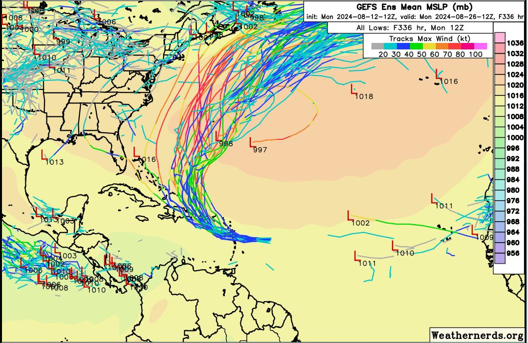
12z GEFS... Still overwhelmingly N after PR, but some W stragglers...
0 likes
Hurricane Eye Experience: David 79, Irene 99, Frances 04, Jeanne 04, Wilma 05… Hurricane Brush Experience: Andrew 92, Erin 95, Floyd 99, Matthew 16, Irma 17, Ian 22, Nicole 22…
Who is online
Users browsing this forum: No registered users and 83 guests