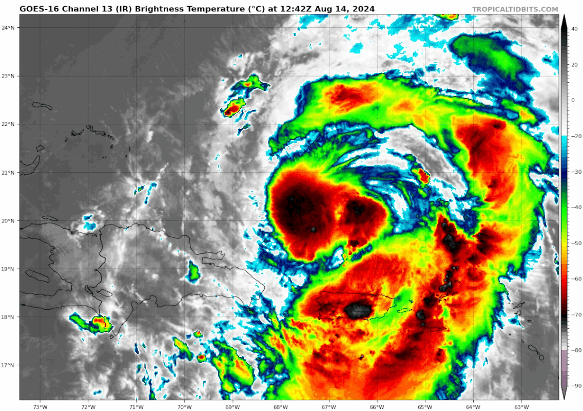
ATL: ERNESTO - Post-Tropical - Discussion

Moderator: S2k Moderators

Message
Author
User avatar
cheezyWXguy
Category 5
Category 5
Posts: 6091
Joined: Mon Feb 13, 2006 12:29 am
Location: Dallas, TX

Re: ATL: ERNESTO - Tropical Storm - Discussion

#281 Postby cheezyWXguy » Wed Aug 14, 2024 7:28 am

Teban54 wrote:
cheezyWXguy wrote:Absurd amount of lightning in the core over the last hour. Radar velocities jumped up at the same time the lightning started too.

Unless I'm mistaken, it looks like most of the lighting was actually taking place in the (disorganized) huge convective blob to the south, rather than the actual CDO to the north of Puerto Rico as indicated by NHC's 18.8N location? Still impressive, but not a direct indication of core building.

https://i.postimg.cc/x13JyBMB/50993454.gif

I was looking at radar, at the time there was a big uptick around the circulation center when the latest burst in your loop occurred
0 likes   

Sciencerocks
Category 5
Category 5
Posts: 8903
Age: 39
Joined: Thu Jul 06, 2017 1:51 am

Re: ATL: ERNESTO - Tropical Storm - Discussion

#282 Postby Sciencerocks » Wed Aug 14, 2024 7:42 am

Image
1 likes   

User avatar
Kazmit
Category 5
Category 5
Posts: 2124
Age: 22
Joined: Mon Jul 25, 2016 8:49 am
Location: Williamsburg, VA / Bermuda

Re: ATL: ERNESTO - Tropical Storm - Discussion

#283 Postby Kazmit » Wed Aug 14, 2024 8:47 am

Recon is finding borderline hurricane-force winds, but well away from the center.
0 likes   
Igor 2010, Sandy 2012, Fay 2014, Gonzalo 2014, Joaquin 2015, Nicole 2016, Humberto 2019

I am only a tropical weather enthusiast. My predictions are not official and may or may not be backed by sound meteorological data. For official information, please refer to the NHC and NWS products.

User avatar
aspen
Category 5
Category 5
Posts: 8812
Joined: Sat Oct 12, 2019 7:10 pm
Location: Connecticut, USA

Re: ATL: ERNESTO - Tropical Storm - Discussion

#284 Postby aspen » Wed Aug 14, 2024 8:54 am

It kinda seems like there’s a bit of shear and/or dry air lurking around Ernesto and keeping a bit of a cap on it for now.

Models keep showing that Ernesto’s UL environment will degrade late Thursday into Friday, with an ULL becoming displaced to the SW and imparting shear into the system. Some have it simply level off, others show weakening. Either way, Ernesto will probably peak by tomorrow night at the latest.
0 likes   
Irene '11 Sandy '12 Hermine '16 5/15/2018 Derecho Fay '20 Isaias '20 Elsa '21 Henri '21 Ida '21

I am only a meteorology enthusiast who knows a decent amount about tropical cyclones. Look to the professional mets, the NHC, or your local weather office for the best information.

User avatar
Ubuntwo
Category 5
Category 5
Posts: 1401
Age: 31
Joined: Thu Oct 05, 2017 10:41 pm

Re: ATL: ERNESTO - Tropical Storm - Discussion

#285 Postby Ubuntwo » Wed Aug 14, 2024 9:15 am

aspen wrote:It kinda seems like there’s a bit of shear and/or dry air lurking around Ernesto and keeping a bit of a cap on it for now.

Models keep showing that Ernesto’s UL environment will degrade late Thursday into Friday, with an ULL becoming displaced to the SW and imparting shear into the system. Some have it simply level off, others show weakening. Either way, Ernesto will probably peak by tomorrow night at the latest.

I don’t see this storm peaking tomorrow night, and definitely not earlier. It will almost certainly have a well-developed core offering some resiliency to steadily increasing shear. Shear also appears to drop moving into Saturday from around 25 knots to as low as 10 knots on a multi model consensus before climbing again, so there is a second window for deepening.
2 likes   
Kendall -> SLO -> PBC

Memorable Storms: Katrina (for its Florida landfall...) Wilma Matthew Irma

underthwx
Category 5
Category 5
Posts: 2351
Joined: Sat Jul 30, 2011 2:14 pm
Location: Brazoria County Texas

Re: ATL: ERNESTO - Tropical Storm - Discussion

#286 Postby underthwx » Wed Aug 14, 2024 9:38 am

Good morning everyone!......Luis.....how are the weather conditions in your area?.....stay safe....and hopefully the cyclone will exit your area quickly!....
2 likes   

User avatar
cheezyWXguy
Category 5
Category 5
Posts: 6091
Joined: Mon Feb 13, 2006 12:29 am
Location: Dallas, TX

Re: ATL: ERNESTO - Tropical Storm - Discussion

#287 Postby cheezyWXguy » Wed Aug 14, 2024 9:40 am

That burst on the northern eyewall is likely the kickoff to the phase where towers start rotating around. I’m expecting a significantly improved appearance by tonight.
0 likes   

Craters
Category 1
Category 1
Posts: 421
Joined: Sat Aug 24, 2013 2:34 pm
Location: Alvin, TX (south of Houston)

Re: ATL: ERNESTO - Tropical Storm - Discussion

#288 Postby Craters » Wed Aug 14, 2024 9:49 am

WaveBreaking wrote:
skyline385 wrote:Anyone know what that is to the NW of Ernesto, looks like an outflow boundary but dont see a reason for it to pop such a strong one at this time

https://i.imgur.com/wRvQUhp.gif


There’s some leftover SAL to its NW that accompanied Ernesto when it first came off the coast of Africa. Since there’s little to no shear, the dry air stayed away from Ernesto’s moisture envelope.

If you don't mind my asking, how does the shear factor into whether the dry air makes it into the circulation or not? There were discussions about that during Beryl, but I didn't get to ask the question back then. (I was too busy battening down the house's hatches and stuff before it hit.)

Thanks!
0 likes   
Nothing that I post here should ever be treated as a forecast or anything resembling one. Please check with your local NWS office or the NHC for forecasts, watches, and warnings.

User avatar
aspen
Category 5
Category 5
Posts: 8812
Joined: Sat Oct 12, 2019 7:10 pm
Location: Connecticut, USA

Re: ATL: ERNESTO - Hurricane - Discussion

#289 Postby aspen » Wed Aug 14, 2024 10:02 am

The 11am discussion mentions the shear on the models that I’ve brought up a few times before. I still think it’s quite possible Ernesto just misses out on MH intensity as a result.

Although Ernesto is moving over very warm waters, the hurricane
might have to deal with bouts of increased shear and nearby dry
air during the next several days. That said, the intensity
guidance shows continued gradual strengthening, and the official
forecast still reflects the possibility of Ernesto becoming a major
hurricane in about 48 hours. Much of the intensity guidance has
come down on the peak intensity this cycle, but for now we'll
maintain continuity and wait to see if this trend continues.
0 likes   
Irene '11 Sandy '12 Hermine '16 5/15/2018 Derecho Fay '20 Isaias '20 Elsa '21 Henri '21 Ida '21

I am only a meteorology enthusiast who knows a decent amount about tropical cyclones. Look to the professional mets, the NHC, or your local weather office for the best information.

MarioProtVI
Category 4
Category 4
Posts: 932
Age: 23
Joined: Sun Sep 29, 2019 7:33 pm
Location: New Jersey

Re: ATL: ERNESTO - Hurricane - Discussion

#290 Postby MarioProtVI » Wed Aug 14, 2024 10:14 am

aspen wrote:The 11am discussion mentions the shear on the models that I’ve brought up a few times before. I still think it’s quite possible Ernesto just misses out on MH intensity as a result.

Although Ernesto is moving over very warm waters, the hurricane
might have to deal with bouts of increased shear and nearby dry
air during the next several days. That said, the intensity
guidance shows continued gradual strengthening, and the official
forecast still reflects the possibility of Ernesto becoming a major
hurricane in about 48 hours. Much of the intensity guidance has
come down on the peak intensity this cycle, but for now we'll
maintain continuity and wait to see if this trend continues.

I think the down tick is because Ernesto is taking a bit slower than they expected. If Ernesto significantly improves by tonight appearance wise (which is likely IMO) and has a concentrated wind field, I think they will keep it. Large C3s are a thing (see Larry, etc) it’s just C4+ that’s hard.
0 likes   

User avatar
Teban54
Category 5
Category 5
Posts: 3168
Joined: Sat May 19, 2018 1:19 pm

Re: ATL: ERNESTO - Tropical Storm - Discussion

#291 Postby Teban54 » Wed Aug 14, 2024 10:20 am

cheezyWXguy wrote:That burst on the northern eyewall is likely the kickoff to the phase where towers start rotating around. I’m expecting a significantly improved appearance by tonight.

Look like that burst is still fighting dry air. However, I had the same thoughts about Ampil in the WPAC yesterday, and it had just cleared out an eye moments ago.

Meanwhile, in case anyone hadn't noticed, 11am advisory upgrades it to a hurricane:
BULLETIN
Hurricane Ernesto Advisory Number 12
NWS National Hurricane Center Miami FL AL052024
1100 AM AST Wed Aug 14 2024

...ERNESTO BECOMES A HURRICANE NORTH OF PUERTO RICO...
...SIGNIFICANT FLOODING LIKELY ACROSS PUERTO RICO AND THE VIRGIN
ISLANDS AS HEAVY RAINS PERSIST...


SUMMARY OF 1100 AM AST...1500 UTC...INFORMATION
-----------------------------------------------
LOCATION...20.5N 67.6W
ABOUT 175 MI...280 KM NW OF SAN JUAN PUERTO RICO
ABOUT 835 MI...1340 KM SSW OF BERMUDA
MAXIMUM SUSTAINED WINDS...75 MPH...120 KM/H
PRESENT MOVEMENT...NW OR 310 DEGREES AT 16 MPH...26 KM/H
MINIMUM CENTRAL PRESSURE...991 MB...29.27 INCHES


Image
2 likes   

User avatar
Teban54
Category 5
Category 5
Posts: 3168
Joined: Sat May 19, 2018 1:19 pm

Re: ATL: ERNESTO - Hurricane - Discussion

#292 Postby Teban54 » Wed Aug 14, 2024 10:28 am

MarioProtVI wrote:I think the down tick is because Ernesto is taking a bit slower than they expected.

Ernesto officially became a hurricane today at 1500z. That's almost exactly what yesterday's 11am and 11pm advisories were calling for (65 kts at 12z); the 11am advisory was the first to show a hurricane immediately north of PR, and was explicitly noted to be more aggressive than previous ones, which generally didn't have an H until 0z 8/15.

Yesterday's 5pm advisory was the only one that may have ended up overly aggressive, as it had 65 kt at 6z and 75 kt at 18z. But that may also easily be an interpolation issue.

In short, I don't think Ernesto is really intensifying more slowly than the NHC forecasts, nor that it matters much in the long term.
1 likes   

User avatar
TheBurn
Category 2
Category 2
Posts: 540
Joined: Thu Jul 28, 2005 4:00 pm
Location: Rincon, PR

Re: ATL: ERNESTO - Hurricane - Discussion

#293 Postby TheBurn » Wed Aug 14, 2024 10:36 am

Image
1 likes   

User avatar
cycloneye
Admin
Admin
Posts: 143874
Age: 68
Joined: Thu Oct 10, 2002 10:54 am
Location: San Juan, Puerto Rico

Re: ATL: ERNESTO - Hurricane - Discussion

#294 Postby cycloneye » Wed Aug 14, 2024 10:37 am

0 likes   
Visit the Caribbean-Central America Weather Thread where you can find at first post web cams,radars
and observations from Caribbean basin members Click Here

Sciencerocks
Category 5
Category 5
Posts: 8903
Age: 39
Joined: Thu Jul 06, 2017 1:51 am

Re: ATL: ERNESTO - Hurricane - Discussion

#295 Postby Sciencerocks » Wed Aug 14, 2024 11:04 am

Image
1 likes   

User avatar
InfernoFlameCat
Category 5
Category 5
Posts: 2102
Age: 22
Joined: Mon Dec 14, 2020 10:52 am
Location: Buford, GA

Re: ATL: ERNESTO - Hurricane - Discussion

#296 Postby InfernoFlameCat » Wed Aug 14, 2024 11:09 am

Big burst of convection over the center. I am curious if Ernesto will RI.
0 likes   
I am by no means a professional. DO NOT look at my forecasts for official information or make decisions based on what I post.

Goal: to become a registered expert over tropical and subtropical cyclones.

User avatar
Ubuntwo
Category 5
Category 5
Posts: 1401
Age: 31
Joined: Thu Oct 05, 2017 10:41 pm

Re: ATL: ERNESTO - Hurricane - Discussion

#297 Postby Ubuntwo » Wed Aug 14, 2024 11:15 am

InfernoFlameCat wrote:Big burst of convection over the center. I am curious if Ernesto will RI.

It technically did hit RI criteria between yesterday and today’s 5 AM - 35 kt to 60 kt.
5 likes   
Kendall -> SLO -> PBC

Memorable Storms: Katrina (for its Florida landfall...) Wilma Matthew Irma

User avatar
abajan
S2K Supporter
S2K Supporter
Posts: 4229
Joined: Sun Sep 07, 2003 5:10 am
Location: Barbados

Re: ATL: ERNESTO - Hurricane - Discussion

#298 Postby abajan » Wed Aug 14, 2024 11:28 am


Interesting to see the east-to-west progression of what appear to be flash-flood warnings in Puerto Rico.
0 likes   

User avatar
Nimbus
Category 5
Category 5
Posts: 5274
Joined: Mon Jul 19, 2004 10:54 am

Re: ATL: ERNESTO - Hurricane - Discussion

#299 Postby Nimbus » Wed Aug 14, 2024 11:33 am

Ernesto made it far enough west that he can pull moist inflow up through the Mona passage.
The island land mass of Puerto Rico was inhibiting overnight.
3 likes   

TallyTracker
Category 2
Category 2
Posts: 719
Joined: Thu Oct 11, 2018 2:46 pm

Re: ATL: ERNESTO - Hurricane - Discussion

#300 Postby TallyTracker » Wed Aug 14, 2024 12:36 pm

The convection is still pulsing rather than holding steady. That’s definitely a sign of some dry air intrusion. Until that is mixed out and a closed core established, only slow strengthening is likely to occur IMO.
1 likes   
Fran '96, Georges '98, Gordon '00, Gabrielle '01, Charley '04, Frances '04, Jeanne '04, Barry '07, Fay '08, Debby '12, Matthew '16, Emily '17, Irma '17, Michael ‘18, Elsa ‘21, Fred ‘21, Mindy ‘21, Nicole ‘22, Idalia ‘23, Debby ‘24, Helene ‘24


Return to “2024”

Who is online

Users browsing this forum: No registered users and 34 guests