
https://x.com/dmorris9661/status/1823464322644816171
2024 Indicators: SST's, MSLP, Shear, SAL, Steering, Instability (Day 16+ Climate Models)
Moderator: S2k Moderators
Forum rules

The posts in this forum are NOT official forecasts and should not be used as such. They are just the opinion of the poster and may or may not be backed by sound meteorological data. They are NOT endorsed by any professional institution or STORM2K. For official information, please refer to products from the National Hurricane Center and National Weather Service.
-
WaveBreaking

- Category 2

- Posts: 717
- Joined: Sun Jun 30, 2024 11:33 am
- Location: US
Re: 2024 Indicators: SST's, MSLP, Shear, SAL, Steering, Instability (Day 16+ Climate Models)
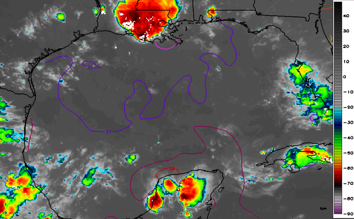
That wave just off the coast of Equatorial Guinea Guinea-Bissau has decent convection and pretty much a closed circulation. Wonder why none of the models show development.

Last edited by WaveBreaking on Thu Aug 15, 2024 3:37 pm, edited 3 times in total.
2 likes
I am NOT a professional meteorologist, so take all of my posts with a grain of salt. My opinions are mine and mine alone.
-
toad strangler

- S2K Supporter

- Posts: 4546
- Joined: Sun Jul 28, 2013 3:09 pm
- Location: Earth
- Contact:
Re: 2024 Indicators: SST's, MSLP, Shear, SAL, Steering, Instability (Day 16+ Climate Models)
WaveBreaking wrote:That wave just off the coast of Equatorial Guinea has decent convection and pretty much a closed circulation. Wonder why none of the models show development.
https://i.imgur.com/t7VXA8R.gif
If I had to guess, it would be that these models just aren't effective enough to trust pre genesis. Same ol same ol but I'm not criticizing any individual model. Wx modeling is still a vast unknown frontier when it comes to reliability.
4 likes
My Weather Station
https://www.wunderground.com/dashboard/pws/KFLPORTS603
https://www.wunderground.com/dashboard/pws/KFLPORTS603

Re: 2024 Indicators: SST's, MSLP, Shear, SAL, Steering, Instability (Day 16+ Climate Models)
WaveBreaking wrote:That wave just off the coast of Equatorial Guinea has decent convection and pretty much a closed circulation. Wonder why none of the models show development.
https://i.imgur.com/t7VXA8R.gif
Not to detract from your post but... I think that's just regular, non-equatorial Guinea
2 likes
-
WaveBreaking
- Category 2
- Posts: 717
- Joined: Sun Jun 30, 2024 11:33 am
- Location: US
Re: 2024 Indicators: SST's, MSLP, Shear, SAL, Steering, Instability (Day 16+ Climate Models)
Beef Stew wrote:WaveBreaking wrote:That wave just off the coast of Equatorial Guinea has decent convection and pretty much a closed circulation. Wonder why none of the models show development.
https://i.imgur.com/t7VXA8R.gif
Not to detract from your post but... I think that's just regular, non-equatorial Guinea
Yeah that’s my bad. I was too lazy to check which Guinea was there
1 likes
I am NOT a professional meteorologist, so take all of my posts with a grain of salt. My opinions are mine and mine alone.
-
SFLcane

- S2K Supporter
- Posts: 10281
- Age: 48
- Joined: Sat Jun 05, 2010 1:44 pm
- Location: Lake Worth Florida
Re: 2024 Indicators: SST's, MSLP, Shear, SAL, Steering, Instability (Day 16+ Climate Models)
Incase there’s some doubt about those CPC probabilities.
https://x.com/blamarre/status/1824207716895625361
https://x.com/blamarre/status/1824207716895625361
0 likes
-
Iceresistance

- Category 5

- Posts: 9579
- Age: 22
- Joined: Sat Oct 10, 2020 9:45 am
- Location: Tecumseh, OK/Norman, OK
Re: 2024 Indicators: SST's, MSLP, Shear, SAL, Steering, Instability (Day 16+ Climate Models)
5 likes
Bill 2015 & Beta 2020
Winter 2020-2021
All observations are in Tecumseh, OK unless otherwise noted.
Winter posts are focused mainly for Oklahoma & Texas.
Take any of my forecasts with a grain of salt, refer to the NWS, SPC, and NHC for official information
Never say Never with weather! Because ANYTHING is possible!
Winter 2020-2021
All observations are in Tecumseh, OK unless otherwise noted.
Winter posts are focused mainly for Oklahoma & Texas.
Take any of my forecasts with a grain of salt, refer to the NWS, SPC, and NHC for official information
Never say Never with weather! Because ANYTHING is possible!


Re: 2024 Indicators: SST's, MSLP, Shear, SAL, Steering, Instability (Day 16+ Climate Models)
SFLcane wrote:Incase there’s some doubt about those CPC probabilities.
https://x.com/blamarre/status/1824207716895625361
I smell a lot of out to sea tracks al la 2010 with that outlook. That is assuming anything will be able to develop in the next 2 weeks or so given the ITCZ being so far north leading to tropical waves coming off and struggling with dry air. Think we'll have to wait a while before the ITCZ sinks back south and by that time those hyperactive hurricane season forecasts could very well be in jeopardy. Only so much can happen in September and you can never really expect October/November to produce. Not season canceling of course but I don't see as favorable as a set up going into peak of the season as I did a month or two ago.
4 likes
-
Stratton23
- Category 5
- Posts: 3517
- Joined: Fri Jul 21, 2023 10:59 pm
- Location: Katy, Tx
Re: 2024 Indicators: SST's, MSLP, Shear, SAL, Steering, Instability (Day 16+ Climate Models)
I disagree here, its still a very favorable setup and those development zones definitely dont mean recurves for sure, the ITCZ will be sinking back south by the last week of august, still looks very busy ahead
1 likes
-
Category5Kaiju

- Category 5
- Posts: 4330
- Joined: Thu Dec 24, 2020 12:45 pm
- Location: Seattle and Phoenix
Re: 2024 Indicators: SST's, MSLP, Shear, SAL, Steering, Instability (Day 16+ Climate Models)
WiscoWx02 wrote:SFLcane wrote:Incase there’s some doubt about those CPC probabilities.
https://x.com/blamarre/status/1824207716895625361
I smell a lot of out to sea tracks al la 2010 with that outlook. That is assuming anything will be able to develop in the next 2 weeks or so given the ITCZ being so far north leading to tropical waves coming off and struggling with dry air. Think we'll have to wait a while before the ITCZ sinks back south and by that time those hyperactive hurricane season forecasts could very well be in jeopardy. Only so much can happen in September and you can never really expect October/November to produce. Not season canceling of course but I don't see as favorable as a set up going into peak of the season as I did a month or two ago.
I kindly suggest you look at the Septembers of seasons such as 1926, 1933, 1961, 1998, 1999, 2004, and 2017 (all hyperactive years of course). I think people vastly underestimate how rapidly and how much ACE can accumulate during that month alone. Also, there's no reason imho to think that a 2010 redux is going to happen in terms of tracks. Every storm that has formed this season so far has made landfall over some landmass in the tropical Atlantic, so I don't see a glaring reason why this would not be the case going forward.
5 likes
Unless explicitly stated, all info in my posts is based on my own opinions and observations. Tropical storms and hurricanes can be extremely dangerous. Refer to an accredited weather research agency or meteorologist if you need to make serious decisions regarding an approaching storm.
Re: 2024 Indicators: SST's, MSLP, Shear, SAL, Steering, Instability (Day 16+ Climate Models)
NAO is forecasted by climate models to be positive during September.
2 likes
-
Category5Kaiju
- Category 5
- Posts: 4330
- Joined: Thu Dec 24, 2020 12:45 pm
- Location: Seattle and Phoenix
Re: 2024 Indicators: SST's, MSLP, Shear, SAL, Steering, Instability (Day 16+ Climate Models)
Also just for fun, while we wait for Ernesto to leave the scene and for whatever future activity will occur, just remember that this happened:
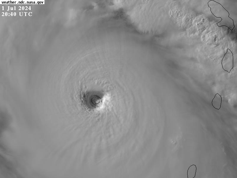
No, that's not a typhoon. That's a bona fide Atlantic hurricane in early July.
So....make whatever you would like out of that. I'm still on board with the idea that this season will prove to be a potentially very impactful and active one once it's all over. And I think there are waaay more positive than negative signs pointing in that direction, unfortunately.
11 likes
Unless explicitly stated, all info in my posts is based on my own opinions and observations. Tropical storms and hurricanes can be extremely dangerous. Refer to an accredited weather research agency or meteorologist if you need to make serious decisions regarding an approaching storm.
-
MarioProtVI
- Category 5
- Posts: 1034
- Age: 24
- Joined: Sun Sep 29, 2019 7:33 pm
- Location: New Jersey
Re: 2024 Indicators: SST's, MSLP, Shear, SAL, Steering, Instability (Day 16+ Climate Models)
WiscoWx02 wrote:SFLcane wrote:Incase there’s some doubt about those CPC probabilities.
https://x.com/blamarre/status/1824207716895625361
I smell a lot of out to sea tracks al la 2010 with that outlook. That is assuming anything will be able to develop in the next 2 weeks or so given the ITCZ being so far north leading to tropical waves coming off and struggling with dry air. Think we'll have to wait a while before the ITCZ sinks back south and by that time those hyperactive hurricane season forecasts could very well be in jeopardy. Only so much can happen in September and you can never really expect October/November to produce. Not season canceling of course but I don't see as favorable as a set up going into peak of the season as I did a month or two ago.
ITCZ will sink back down by month’s end + ensembles are already lighting up on a bunch of activity by ~25th-28th. CFS also has several storms in the MDR first week of September IIRC, which on that res would probably be at least a C1-2, probably even majors.
2 likes
-
wxman57

- Moderator-Pro Met

- Posts: 23171
- Age: 68
- Joined: Sat Jun 21, 2003 8:06 pm
- Location: Houston, TX (southwest)
Re: 2024 Indicators: SST's, MSLP, Shear, SAL, Steering, Instability (Day 16+ Climate Models)
Category5Kaiju wrote:Also just for fun, while we wait for Ernesto to leave the scene and for whatever future activity will occur, just remember that this happened:
https://pbs.twimg.com/media/GRbigq1WsAA74Yl?format=png&name=900x900
No, that's not a typhoon. That's a bona fide Atlantic hurricane in early July.
So....make whatever you would like out of that. I'm still on board with the idea that this season will prove to be a potentially very impactful and active one once it's all over. And I think there are waaay more positive than negative signs pointing in that direction, unfortunately.
Looks like an anticyclonic eddy in Beryl's eye. Very odd.
0 likes
-
wxman57
- Moderator-Pro Met
- Posts: 23171
- Age: 68
- Joined: Sat Jun 21, 2003 8:06 pm
- Location: Houston, TX (southwest)
Re: 2024 Indicators: SST's, MSLP, Shear, SAL, Steering, Instability (Day 16+ Climate Models)
I've been discussing the seasonal predictions with Klotzbach over the past couple of weeks. I was sure he'd lower his predicted numbers in his August update, but he raised them by two named storms. His argument was that the seasonal prediction parameters all point to hyperactivity. Very warm water, low shear in deep tropics, etc. However, I pointed out that the atmosphere just doesn't seem as favorable as the models are/were predicting, and that warm water alone won't generate more named storms. The waves coming off Africa are way weaker than normal, and they're struggling. There are three waves out there now, one near the Caribbean, one along 23W, and another along 43W. None of these waves looks likely to develop, though I'd keep an eye on the two eastern waves to see if they flare up in the western Caribbean in 7-10 days. Some unforeseen conditions are making the tropics less hospitable than predicted.
5 likes
-
SFLcane
- S2K Supporter
- Posts: 10281
- Age: 48
- Joined: Sat Jun 05, 2010 1:44 pm
- Location: Lake Worth Florida
Re: 2024 Indicators: SST's, MSLP, Shear, SAL, Steering, Instability (Day 16+ Climate Models)
WiscoWx02 wrote:SFLcane wrote:Incase there’s some doubt about those CPC probabilities.
https://x.com/blamarre/status/1824207716895625361
I smell a lot of out to sea tracks al la 2010 with that outlook. That is assuming anything will be able to develop in the next 2 weeks or so given the ITCZ being so far north leading to tropical waves coming off and struggling with dry air. Think we'll have to wait a while before the ITCZ sinks back south and by that time those hyperactive hurricane season forecasts could very well be in jeopardy. Only so much can happen in September and you can never really expect October/November to produce. Not season canceling of course but I don't see as favorable as a set up going into peak of the season as I did a month or two ago.
With what outlook lol those aren't tc tracks they show development potential in those hatched areas. Again as i stressed in the other models thread we have had 3 hurricanes and all of them have hit land whether thats a trend or not who knows. We are just in the first inning its only the second week of aug.
0 likes
-
Stratton23
- Category 5
- Posts: 3517
- Joined: Fri Jul 21, 2023 10:59 pm
- Location: Katy, Tx
Re: 2024 Indicators: SST's, MSLP, Shear, SAL, Steering, Instability (Day 16+ Climate Models)
wxman57 i dont think its unforseen, the waves are coming off of africa at a higher latitude off of africa and. immediately are running into dry and stable SAL air which is killing them off, also the ITCZ is well to the north which isnt helping the waves either, the ITCZ will be sinking south over the last week of august so waves should eventually start coming off more south again so definitely they wont all be getting choked off, I can see his argument as to why he increased by a few named storms, this is more of a temporary hinderance than long term
2 likes
-
Category5Kaiju
- Category 5
- Posts: 4330
- Joined: Thu Dec 24, 2020 12:45 pm
- Location: Seattle and Phoenix
Re: 2024 Indicators: SST's, MSLP, Shear, SAL, Steering, Instability (Day 16+ Climate Models)
The background forcing seems to be there. I’m willing to bet that we’re going to see something form in the deep tropics before August 31st. And given the way this season has been behaving, don’t be surprised if our next storm or two down the line ends up becoming a strong, major hurricane.
0 likes
Unless explicitly stated, all info in my posts is based on my own opinions and observations. Tropical storms and hurricanes can be extremely dangerous. Refer to an accredited weather research agency or meteorologist if you need to make serious decisions regarding an approaching storm.
Re: 2024 Indicators: SST's, MSLP, Shear, SAL, Steering, Instability (Day 16+ Climate Models)
wxman57 wrote:I've been discussing the seasonal predictions with Klotzbach over the past couple of weeks. I was sure he'd lower his predicted numbers in his August update, but he raised them by two named storms. His argument was that the seasonal prediction parameters all point to hyperactivity. Very warm water, low shear in deep tropics, etc. However, I pointed out that the atmosphere just doesn't seem as favorable as the models are/were predicting, and that warm water alone won't generate more named storms. The waves coming off Africa are way weaker than normal, and they're struggling. There are three waves out there now, one near the Caribbean, one along 23W, and another along 43W. None of these waves looks likely to develop, though I'd keep an eye on the two eastern waves to see if they flare up in the western Caribbean in 7-10 days. Some unforeseen conditions are making the tropics less hospitable than predicted.
Always appreciate your updates!
CSU didn’t raise # of NS in Aug update by two. They lowered it by two from 25 to 23 due to the long stretch of quiet between Chris and Debby. I think you’re mixing up their July and Aug forecasts as July’s 25 was 2 higher than June’s 23. Are you thinking about their July forecast? So, since May, their #NS have been 23, 23, 25, 23:
https://tropical.colostate.edu/Forecast/2024-08.pdf
5 likes
Personal Forecast Disclaimer:
The posts in this forum are NOT official forecasts and should not be used as such. They are just the opinion of the poster and may or may not be backed by sound meteorological data. They are NOT endorsed by any professional institution or storm2k.org. For official information, please refer to the NHC and NWS products.
The posts in this forum are NOT official forecasts and should not be used as such. They are just the opinion of the poster and may or may not be backed by sound meteorological data. They are NOT endorsed by any professional institution or storm2k.org. For official information, please refer to the NHC and NWS products.
Who is online
Users browsing this forum: Teban54 and 81 guests