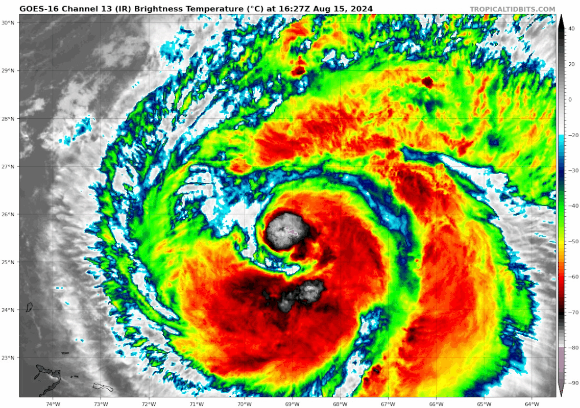
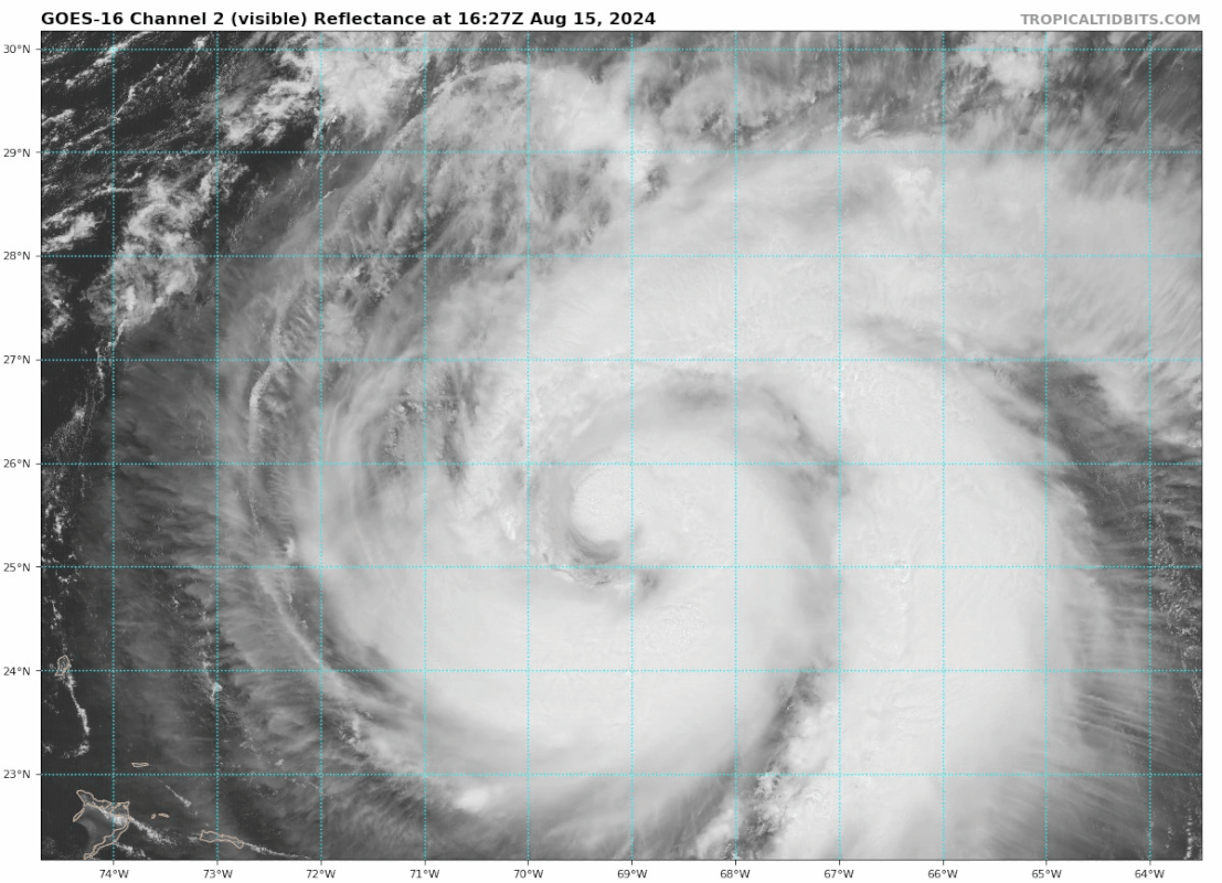
ATL: ERNESTO - Post-Tropical - Discussion

Moderator: S2k Moderators

Message
Author
LarryWx
Category 5
Category 5
Posts: 6246
Joined: Sun Sep 07, 2003 2:04 pm
Location: GA

Re: ATL: ERNESTO - Hurricane - Discussion

#381 Postby LarryWx » Thu Aug 15, 2024 2:00 pm

Kazmit wrote:
LarryWx wrote:
Kazmit wrote:Not strengthening very quickly but it has a large area of hurricane force winds to the east. Bermuda will have a decent stretch of 65kt+ winds. Luckily it shouldn’t be too bad as we are no stranger to direct cat 1-2 impacts- seems to occur every couple of years.


One thing that ACE and SS scale don’t reflect on well is diameter of strong winds/size of storm.

Someone should develop a system like ACE using pressure instead of wind speed as a metric.


Joe Bastardi has a power and impact scale that I think is an excellent idea.
1 likes   
Personal Forecast Disclaimer:
The posts in this forum are NOT official forecasts and should not be used as such. They are just the opinion of the poster and may or may not be backed by sound meteorological data. They are NOT endorsed by any professional institution or storm2k.org. For official information, please refer to the NHC and NWS products.

User avatar
Teban54
Category 5
Category 5
Posts: 3168
Joined: Sat May 19, 2018 1:19 pm

Re: ATL: ERNESTO - Hurricane - Discussion

#382 Postby Teban54 » Thu Aug 15, 2024 2:22 pm

Image

Image
1 likes   

User avatar
HurricaneBelle
S2K Supporter
S2K Supporter
Posts: 1169
Joined: Sun Aug 27, 2006 6:12 pm
Location: Clearwater, FL

Re: ATL: ERNESTO - Hurricane - Discussion

#383 Postby HurricaneBelle » Thu Aug 15, 2024 2:52 pm

Kazmit wrote:
LarryWx wrote:
Kazmit wrote:Not strengthening very quickly but it has a large area of hurricane force winds to the east. Bermuda will have a decent stretch of 65kt+ winds. Luckily it shouldn’t be too bad as we are no stranger to direct cat 1-2 impacts- seems to occur every couple of years.


One thing that ACE and SS scale don’t reflect on well is diameter of strong winds/size of storm.

Someone should develop a system like ACE using pressure instead of wind speed as a metric.


While pressure seems more objective than wind speeds which have to be estimated or measured by a plane that can't be everywhere at one time, there is still the gradient to consider as intensity also depends on the contrast with the ambient pressures in the area. Also pressure itself doesn't cause damage, winds and surge generated by those winds do.
2 likes   

Sciencerocks
Category 5
Category 5
Posts: 8903
Age: 39
Joined: Thu Jul 06, 2017 1:51 am

Re: ATL: ERNESTO - Hurricane - Discussion

#384 Postby Sciencerocks » Thu Aug 15, 2024 3:19 pm

Image
1 likes   

User avatar
ScottNAtlanta
Category 5
Category 5
Posts: 2360
Joined: Sat May 25, 2013 3:11 pm
Location: Atlanta, GA

Re: ATL: ERNESTO - Hurricane - Discussion

#385 Postby ScottNAtlanta » Thu Aug 15, 2024 4:18 pm

This storm has been trying to close off an eye for 2 days and failed every time. I don't think I have seen that in recent memory. Usually if dry air gets in, the storm mixes it out...not this one.
2 likes   
The posts in this forum are NOT official forecast and should not be used as such. They are just the opinion of the poster and may or may not be backed by sound meteorological data. They are NOT endorsed by any professional institution or storm2k.org. For official information, please refer to the NHC and NWS products.

hipshot
Category 2
Category 2
Posts: 591
Joined: Tue Jul 06, 2010 9:18 pm
Location: Dallas, Texas

Re: ATL: ERNESTO - Hurricane - Discussion

#386 Postby hipshot » Thu Aug 15, 2024 4:28 pm

ScottNAtlanta wrote:This storm has been trying to close off an eye for 2 days and failed every time. I don't think I have seen that in recent memory. Usually if dry air gets in, the storm mixes it out...not this one.


The last frame sure looked like a closed eye was just about there. Let's see what it looks like on the next pass or 2.
0 likes   

User avatar
Travorum
Category 1
Category 1
Posts: 406
Joined: Tue Sep 05, 2023 9:36 am
Location: Dunedin, FL

Re: ATL: ERNESTO - Hurricane - Discussion

#387 Postby Travorum » Thu Aug 15, 2024 4:34 pm

hipshot wrote:
ScottNAtlanta wrote:This storm has been trying to close off an eye for 2 days and failed every time. I don't think I have seen that in recent memory. Usually if dry air gets in, the storm mixes it out...not this one.


The last frame sure looked like a closed eye was just about there. Let's see what it looks like on the next pass or 2.

It's still got a bit to close off in the west as of an hour ago but it looks like a much more robust structure is developing.
Image
1 likes   

USTropics
Category 5
Category 5
Posts: 2636
Joined: Sun Aug 12, 2007 3:45 am
Location: Florida State University

Re: ATL: ERNESTO - Hurricane - Discussion

#388 Postby USTropics » Thu Aug 15, 2024 5:00 pm

HurricaneBelle wrote:
Kazmit wrote:
LarryWx wrote:
One thing that ACE and SS scale don’t reflect on well is diameter of strong winds/size of storm.

Someone should develop a system like ACE using pressure instead of wind speed as a metric.


While pressure seems more objective than wind speeds which have to be estimated or measured by a plane that can't be everywhere at one time, there is still the gradient to consider as intensity also depends on the contrast with the ambient pressures in the area. Also pressure itself doesn't cause damage, winds and surge generated by those winds do.


ACE is a cheap way to measure energy, and it can be used with limited points of obs (which makes it useful for climatology). There was a new method (and more effective at measuring the destructive nature of tropical cyclones) that was introduced in 2007 called integrated kinetic energy (IKE) or the ACE equivalent, TIKE (track integrated kinetic energy). This accounts for the structural integrity of the storm and radius of wind field for each quadrant when calculating energy. This is a really good article from some of my fav professors at FSU that goes more into details:

https://journals.ametsoc.org/view/journals/mwre/141/7/mwr-d-12-00349.1.xml
2 likes   

User avatar
lilbump3000
Category 4
Category 4
Posts: 966
Age: 37
Joined: Sat Sep 20, 2003 10:09 am
Location: New Orleans, Louisiana
Contact:

Re: ATL: ERNESTO - Hurricane - Discussion

#389 Postby lilbump3000 » Thu Aug 15, 2024 5:11 pm

1 likes   

User avatar
Kazmit
Category 5
Category 5
Posts: 2124
Age: 22
Joined: Mon Jul 25, 2016 8:49 am
Location: Williamsburg, VA / Bermuda

Re: ATL: ERNESTO - Hurricane - Discussion

#390 Postby Kazmit » Thu Aug 15, 2024 5:24 pm

This is one BIG storm on satellite. If it were in the gulf it would fill the whole thing.

Image
6 likes   
Igor 2010, Sandy 2012, Fay 2014, Gonzalo 2014, Joaquin 2015, Nicole 2016, Humberto 2019

I am only a tropical weather enthusiast. My predictions are not official and may or may not be backed by sound meteorological data. For official information, please refer to the NHC and NWS products.

hipshot
Category 2
Category 2
Posts: 591
Joined: Tue Jul 06, 2010 9:18 pm
Location: Dallas, Texas

Re: ATL: ERNESTO - Hurricane - Discussion

#391 Postby hipshot » Thu Aug 15, 2024 5:28 pm

Kazmit wrote:This is one BIG storm on satellite. If it were in the gulf it would fill the whole thing.

https://i.ibb.co/XFNyHNB/Screen-Shot-2024-08-15-at-6-21-46-PM.png


Yep, we sure wouldn't want that in the Gulf, what a mess that would be.
0 likes   

User avatar
cheezyWXguy
Category 5
Category 5
Posts: 6091
Joined: Mon Feb 13, 2006 12:29 am
Location: Dallas, TX

Re: ATL: ERNESTO - Hurricane - Discussion

#392 Postby cheezyWXguy » Thu Aug 15, 2024 5:57 pm

Latest recon pass shows a MUCH improved sw quadrant in terms of windfield.
2 likes   

User avatar
Travorum
Category 1
Category 1
Posts: 406
Joined: Tue Sep 05, 2023 9:36 am
Location: Dunedin, FL

Re: ATL: ERNESTO - Hurricane - Discussion

#393 Postby Travorum » Thu Aug 15, 2024 6:02 pm

968.8 extrap, steady deepening since the last recon a few hours ago.
1 likes   

User avatar
Hurricane2022
Category 5
Category 5
Posts: 1497
Joined: Tue Aug 23, 2022 11:38 pm
Location: Araçatuba, Brazil

Re: ATL: ERNESTO - Hurricane - Discussion

#394 Postby Hurricane2022 » Thu Aug 15, 2024 6:14 pm

103 kt FL but smfr is only at 56 kt... I think we may have a low-end C2 now...
3 likes   
Sorry for the bad English sometimes...!
For reliable and detailed information for any meteorological phenomenon, please consult the National Hurricane Center, Joint Typhoon Warning Center , or your local Meteo Center.

--------

Una cvm Christo, pro Christo, et in Christo. Sit nomen Domini benedictvm.

User avatar
Travorum
Category 1
Category 1
Posts: 406
Joined: Tue Sep 05, 2023 9:36 am
Location: Dunedin, FL

Re: ATL: ERNESTO - Hurricane - Discussion

#395 Postby Travorum » Thu Aug 15, 2024 6:19 pm

Hurricane2022 wrote:103 kt FL but smfr is only at 56 kt... I think we may have a low-end C2 now...


SFMR closer in did have several 73kt readings, FL winds are likely taking a while to mix down given how big this thing is. Blending 73kt SFMR and 103kt FL could justify 80-85kts so I would agree, low-end C2 seems possible.
Last edited by Travorum on Thu Aug 15, 2024 6:24 pm, edited 1 time in total.
0 likes   

User avatar
ElectricStorm
Category 5
Category 5
Posts: 5017
Age: 24
Joined: Tue Aug 13, 2019 11:23 pm
Location: Skiatook, OK / Norman, OK

Re: ATL: ERNESTO - Hurricane - Discussion

#396 Postby ElectricStorm » Thu Aug 15, 2024 6:24 pm

Looks a lot better organized than last mission. Looks a like a huge core is developing. May take awhile to get the winds up compared to pressure falls with a core/windfield that large, but assuming it's finally done dealing with dry air I think it should be able to reach at least 90-95kts
0 likes   
I am in no way a professional. Take what I say with a grain of salt as I could be totally wrong. Please refer to the NHC, NWS, or SPC for official information.

Boomer Sooner!

User avatar
Nimbus
Category 5
Category 5
Posts: 5274
Joined: Mon Jul 19, 2004 10:54 am

Re: ATL: ERNESTO - Hurricane - Discussion

#397 Postby Nimbus » Thu Aug 15, 2024 6:36 pm

ElectricStorm wrote:Looks a lot better organized than last mission. Looks a like a huge core is developing. May take awhile to get the winds up compared to pressure falls with a core/windfield that large, but assuming it's finally done dealing with dry air I think it should be able to reach at least 90-95kts


Is the trough undercutting the inflow with dry air?
Really can't tell from the water vapor loop but inflow seems drier from the northwest quadrant.
0 likes   

User avatar
Travorum
Category 1
Category 1
Posts: 406
Joined: Tue Sep 05, 2023 9:36 am
Location: Dunedin, FL

Re: ATL: ERNESTO - Hurricane - Discussion

#398 Postby Travorum » Thu Aug 15, 2024 6:44 pm

80kts/970mb for the 8pm update, recon reports a 30nm spiral eyewall.
0 likes   

User avatar
Hurrilurker
Category 2
Category 2
Posts: 719
Joined: Mon Jun 09, 2003 3:32 pm
Location: San Francisco, CA

Re: ATL: ERNESTO - Hurricane - Discussion

#399 Postby Hurrilurker » Thu Aug 15, 2024 6:52 pm

ScottNAtlanta wrote:This storm has been trying to close off an eye for 2 days and failed every time. I don't think I have seen that in recent memory. Usually if dry air gets in, the storm mixes it out...not this one.

Yeah, it's very persistent and keeps getting injected on the west side. Good for Bermuda, anyway. If not for the dry air it could easily be a Cat 4-5 by the time it gets there. Not that I'd relax if I were in Bermuda of course.
1 likes   

User avatar
cheezyWXguy
Category 5
Category 5
Posts: 6091
Joined: Mon Feb 13, 2006 12:29 am
Location: Dallas, TX

Re: ATL: ERNESTO - Hurricane - Discussion

#400 Postby cheezyWXguy » Thu Aug 15, 2024 8:01 pm

Recon shows that the windfield has made significant progress toward symmetrizing since this morning. If it can keep firing off towers tonight a major may not be so unachievable after all
0 likes   


Return to “2024”

Who is online

Users browsing this forum: No registered users and 42 guests