2024 Indicators: SST's, MSLP, Shear, SAL, Steering, Instability (Day 16+ Climate Models)
Moderator: S2k Moderators
Forum rules

The posts in this forum are NOT official forecasts and should not be used as such. They are just the opinion of the poster and may or may not be backed by sound meteorological data. They are NOT endorsed by any professional institution or STORM2K. For official information, please refer to products from the National Hurricane Center and National Weather Service.
-
toad strangler

- S2K Supporter

- Posts: 4546
- Joined: Sun Jul 28, 2013 3:09 pm
- Location: Earth
- Contact:
Re: 2024 Indicators: SST's, MSLP, Shear, SAL, Steering, Instability (Day 16+ Climate Models)
We are in that annual sweet spot of pre peak season anxiety. Hobbyists, chasers, AND even some meteorologists aren’t immune to this when in many seasons, the 1st half of August is dead and the medium range models aren’t enthused heading into the bell ring of 8/20 and the end of August. BUT the huge difference this year is that we have had TWO hurricanes (one US landfall) in the first half of August. With one literally still on the field of play. Yet, there is this hint of trust anyway in these medium range models showing almost nothing. Bizzare. Bizzare I say 
10 likes
My Weather Station
https://www.wunderground.com/dashboard/pws/KFLPORTS603
https://www.wunderground.com/dashboard/pws/KFLPORTS603
-
tolakram
- Admin

- Posts: 20178
- Age: 62
- Joined: Sun Aug 27, 2006 8:23 pm
- Location: Florence, KY (name is Mark)
Re: 2024 Indicators: SST's, MSLP, Shear, SAL, Steering, Instability (Day 16+ Climate Models)
This season can't do anything except disappoint.
In my opinion, and this is a strong one. Counting storms is NOT objective, it's subjective. If we have 8 cat 5 hurricanes this season and that's all, was it slow? It's just silly and can do nothing except hurt the institutions that live or die by the numbers.
If this season ends up unusually inactive, and I'm not predicting that, maybe some improvements will result. Since we've already had a cat 5 in July, if this season ends up being unusually inactive what will that tell us?
And I think it was in this thread, hopefully quoted, that there's no spring barrier this year.
Honestly I think cold neutral is far worse (more activity) than a full la nina anyway.
8 likes
M a r k
- - - - -
Join us in chat: Storm2K Chatroom Invite. Android and IOS apps also available.
The posts in this forum are NOT official forecasts and should not be used as such. Posts are NOT endorsed by any professional institution or STORM2K.org. For official information and forecasts, please refer to NHC and NWS products.
-
cycloneye

- Admin
- Posts: 149267
- Age: 69
- Joined: Thu Oct 10, 2002 10:54 am
- Location: San Juan, Puerto Rico
Re: 2024 Indicators: SST's, MSLP, Shear, SAL, Steering, Instability (Day 16+ Climate Models)
toad strangler wrote:We are in that annual sweet spot of pre peak season anxiety. Hobbyists, chasers, AND even some meteorologists aren’t immune to this when in many seasons, the 1st half of August is dead and the medium range models aren’t enthused heading into the bell ring of 8/20 and the end of August. BUT the huge difference this year is that we have had TWO hurricanes (one US landfall) in the first half of August. With one literally still on the field of play. Yet, there is this hint of trust anyway in these medium models showing almost nothing. Bizzare. Bizzare I say
Also already, this season has a lot of ACE produced and that is very important in terms of having a hyperactive season. So far 2024 season has 47.4 ACE units and having 160 is the threshold to be hyperactive.
1 likes
Visit the Caribbean-Central America Weather Thread where you can find at first post web cams,radars
and observations from Caribbean basin members Click Here
and observations from Caribbean basin members Click Here
-
AnnularCane

- S2K Supporter
- Posts: 2957
- Joined: Thu Jun 08, 2006 9:18 am
- Location: Wytheville, VA
Re: 2024 Indicators: SST's, MSLP, Shear, SAL, Steering, Instability (Day 16+ Climate Models)
toad strangler wrote:We are in that annual sweet spot of pre peak season anxiety. Hobbyists, chasers, AND even some meteorologists aren’t immune to this when in many seasons, the 1st half of August is dead and the medium range models aren’t enthused heading into the bell ring of 8/20 and the end of August. BUT the huge difference this year is that we have had TWO hurricanes (one US landfall) in the first half of August. With one literally still on the field of play. Yet, there is this hint of trust anyway in these medium range models showing almost nothing. Bizzare. Bizzare I say
That happens to me a lot, even though I know better by now.
There is also this sense that something is about to happen.
Last edited by AnnularCane on Fri Aug 16, 2024 11:31 am, edited 1 time in total.
1 likes
"But it never rained rain. It never snowed snow. And it never blew just wind. It rained things like soup and juice. It snowed mashed potatoes and green peas. And sometimes the wind blew in storms of hamburgers." -- Judi Barrett, Cloudy with a Chance of Meatballs
-
Emmett_Brown

- Category 5

- Posts: 1433
- Joined: Wed Aug 24, 2005 9:10 pm
- Location: Sarasota FL
Re: 2024 Indicators: SST's, MSLP, Shear, SAL, Steering, Instability (Day 16+ Climate Models)
Watching our second hurricane of the month head toward land, and then I come over here and it's like crossing into a parallel universe. I guess Active is the new Inactive. For fun, if you want to see an inactive period historically, google 1982 and 1983. Now those 2 years were quiet!
6 likes

Re: 2024 Indicators: SST's, MSLP, Shear, SAL, Steering, Instability (Day 16+ Climate Models)
Agreed 100%. Going back before 1988, more active seasons for ACE as of 8/16 than 2024 were 1933, 1899, 1893, and 1886. There may not be others though I’d have to double check based on the latest.
1 likes
Personal Forecast Disclaimer:
The posts in this forum are NOT official forecasts and should not be used as such. They are just the opinion of the poster and may or may not be backed by sound meteorological data. They are NOT endorsed by any professional institution or storm2k.org. For official information, please refer to the NHC and NWS products.
The posts in this forum are NOT official forecasts and should not be used as such. They are just the opinion of the poster and may or may not be backed by sound meteorological data. They are NOT endorsed by any professional institution or storm2k.org. For official information, please refer to the NHC and NWS products.
-
Hurricane2022

- Category 5
- Posts: 2016
- Joined: Tue Aug 23, 2022 11:38 pm
- Location: Araçatuba, Brazil
Re: 2024 Indicators: SST's, MSLP, Shear, SAL, Steering, Instability (Day 16+ Climate Models)
I admit that maybe 2024 will come out a little slower than expected, but I'm confident that this season will still arrive on November 30th with at least 210 ACE points and final numbers around 21/13/7, becoming so a extremely active hurricane season. I'm waiting for this year's bell to ring between August 25th and September 1st. We are not very far from those dates. It's still good to remember that there are chances of having a backloaded season in terms of intense cyclones, like 2020 for example, but we could also end up like 2017, in which we had a month of September with a record ACE due to Irma, Jose, Katia, Maria and Lee, the "only" 5 storms of that infamous month, and with October and November with more regular activity. Hell, we can also have a mix of 1933, 1995, 2004, 2005, 2010, 2017 and 2020 all at once. That's it, the waters of the Atlantic Ocean have been bubbling since April last year, and we continue on the same line as 2023 in this regard.
Since the problem is that the waves are coming out too far north of Africa, so let's wait for the ITCZ to go back south again and/or for the models to make the common August correction, which is most likely what is happening now.
Since the problem is that the waves are coming out too far north of Africa, so let's wait for the ITCZ to go back south again and/or for the models to make the common August correction, which is most likely what is happening now.
Last edited by Hurricane2022 on Fri Aug 16, 2024 12:17 pm, edited 2 times in total.
4 likes
Sorry for the bad English sometimes...!
For reliable and detailed information for any meteorological phenomenon, please consult the National Hurricane Center, Joint Typhoon Warning Center , or your local Meteo Center.
--------
ECCE OMNIA NOVA FACIAM (Ap 21,5).
For reliable and detailed information for any meteorological phenomenon, please consult the National Hurricane Center, Joint Typhoon Warning Center , or your local Meteo Center.
--------
ECCE OMNIA NOVA FACIAM (Ap 21,5).
-
cycloneye
- Admin
- Posts: 149267
- Age: 69
- Joined: Thu Oct 10, 2002 10:54 am
- Location: San Juan, Puerto Rico
Re: 2024 Indicators: SST's, MSLP, Shear, SAL, Steering, Instability (Day 16+ Climate Models)
As I mentioned in my post above, ACE is the most important metric to see how is a season doing on activity and right now is on pace to be over 200 units, and that is well above the threshold of 165 that is the number for hyperactive.

https://weathertiger.substack.com/p/rea ... -hurricane
https://weathertiger.substack.com/p/rea ... -hurricane
2 likes
Visit the Caribbean-Central America Weather Thread where you can find at first post web cams,radars
and observations from Caribbean basin members Click Here
and observations from Caribbean basin members Click Here

Re: 2024 Indicators: SST's, MSLP, Shear, SAL, Steering, Instability (Day 16+ Climate Models)
Patience is a virtue people.
5 likes

Re: 2024 Indicators: SST's, MSLP, Shear, SAL, Steering, Instability (Day 16+ Climate Models)
This probably needs a bump (regardless of whether Ernesto makes it to Cat 3).
And, amid the talks about deep tropics: In 2017, the deep tropics didn't come alive until August 31st.
And, amid the talks about deep tropics: In 2017, the deep tropics didn't come alive until August 31st.
Teban54 wrote:Now the NHC forecasts Ernesto to become a major on August 16. Key point: That's before the August 20 bell-ringing date.
Amid the Ernesto forecasts followed by the relative quiet period that's currently depicted by the models, it's easy to think Ernesto was supposed to be the first TC outbreak which underperformed. But during recent seasons, the period leading up to August 20 -- sometimes even a few days after -- were often even quieter: without model enthusiasm like right now, but also without a mid-August major, and certainly without a July Cat 5 before that. The bell-ringing period is often known for sudden upticks in both model forecasts and actual activity (that's often poorly forecast by the models beforehand), and the presence of Ernesto shouldn't trick us into thinking that it was the entire uptick.
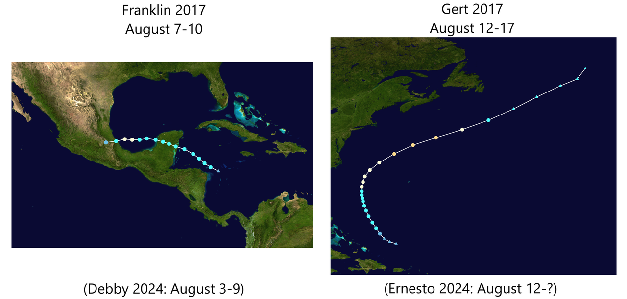
In fact, the most comparable situation to August 2024 so far is actually August 2017. Franklin made landfall on the "Gulf coast" as a Cat 1 just like Debby, and Gert was a recurving Cat 2 in the subtropics, which didn't even form within the MDR like Ernesto did. Even their time periods match 2024 almost exactly.
https://i.postimg.cc/2jL1X1nQ/image.png
Now recall what 2017 did afterwards? Harvey Part I did form in the MDR on August 17, but became a "failed" 40 kt tropical storm that succumbed to shear just 2 days later, and wouldn't have regenerated in the Gulf until August 23. PTC 10 tracked across the Atlantic behind Harvey and "recurved" without development, becoming the first failed PTC in the process. The actual insane MDR activity, which 2017 was well-known for, didn't start until Irma formed on August 30 (16 days from today's date).
During the years that followed...
- Florence 2018 only formed on August 31.
- 2019 had nothing on the models until Chantal rang the bell precisely on August 20. Dorian formed on August 24, and IIRC only started appearing on models during the couple days inbetween.
- 2020 had high quantity even during early season, but its YTD profile was still rather thin with two landfalling Cat 1s (despite 11 storms total). Laura only formed on August 20 and became a hurricane on August 25.
- Grace 2021 RI'ed to a major on August 20 to ring the bell again, but before then, it and Fred were seen as underwhelming "Caribbean kayaks" that weakened or dissipated through the Greater Antilles. The main highlight of the season, Ida, took another 6 days to form.
- 2022 was infamous for a storm-free August, but even then, it still had 2 hurricanes in early September, followed by Fiona and Ian to many people's surprise.
- The trio of Emily, Franklin and Gert 2023 formed right on August 20 (yet again), but while they were hinted at on the models before, nobody could have said with confidence about 3 storms until that day. That August was also completely quiet before that.
Early August 2017 was obviously not what that season was known for, but it was already the most active one since at least 2013. And 2024 is on track to surpass that as per NHC's forecast.
While it's technically not impossible that Ernesto will be the entire "late August outbreak", there's at least a legitimate chance, if not a higher chance, that 2024 is a thought experiment of: "What if we repeat 2017 YTD, but replace its first 5 record-low-ACE TS with 2 TS and a Cat 5?"
3 likes
TC naming lists: retirements and intensity
Most aggressive Advisory #1's in North Atlantic (cr. kevin for starting the list)
Most aggressive Advisory #1's in North Atlantic (cr. kevin for starting the list)
-
Category5Kaiju

- Category 5
- Posts: 4330
- Joined: Thu Dec 24, 2020 12:45 pm
- Location: Seattle and Phoenix
Re: 2024 Indicators: SST's, MSLP, Shear, SAL, Steering, Instability (Day 16+ Climate Models)
Kind of thought about it just for fun, but with how the tropical wx community is like these days, imagine the reactions that people would have if they were to track the 1961 season.
7 likes
Unless explicitly stated, all info in my posts is based on my own opinions and observations. Tropical storms and hurricanes can be extremely dangerous. Refer to an accredited weather research agency or meteorologist if you need to make serious decisions regarding an approaching storm.

Re: 2024 Indicators: SST's, MSLP, Shear, SAL, Steering, Instability (Day 16+ Climate Models)
Here's an overview of the TCs in the latest (00z Friday) CFS run, which runs until November 14. Note that because of the timeframe, the value of a specific run is ~0. But it's more an indicator of which regions in the basin may be most favorable the upcoming months during peak season. Also note that intensity is very very much underestimated by CFS. So I'll only mention TC and not go in detail about the intensity of the TCs in the run.
The thing that sticks out in the run is the anomalously high activity in the MDR, which many of the storms lingering and keeping their intensity quite high up in the subtropics. This would make sense considering the high SSTs. There are almost no landfalling/impacting hurricanes in the whole run, but idk of if that's due to the favorability of the regions that CFS sees or whether it's just a CFS bias. Also nothing in the Gulf or WCar the entire season, which is like impossible. Pressure in the region is low during most of the run, just nothing forms. Probably a resolution issue as I notice CFS often has issues with tropical cyclogenesis close to land. Either way, even without the Gulf & WCar activity the season would be at 18 NS at November 14 based on this run, probably 18/11/5 based on the location of the storms if I'd have to estimate. So also more quality over quantity, basically the same as 2017. Final note, if this CFS run were to materialize the number of storms per month would be June (3), July (0), August (6), September (5), October (3), November (1).
Francine: Aug 20 - 22. A wave enters the Atlantic from Africa quite far north and consolidates over the following days. Doesn't do much because of its latitude, but could a fun little storm.
Gordon: Aug 24 - Sep 2. Another eastern MDR wave, but this time further south. Slowly rides along the entirety of the MDR and recurves safely out to sea.
Helene: Aug 27 - 29. Central MDR wave, doesn't amount to much and recurves.
Isaac: Aug 29 - Sep 1. A vigorous MDR wave which basically drops into the Atlantic as a fully-fledged TC. But shear kills it pretty quick. Basically clears the way for the following storms.
Joyce: Sep 7 - Sep 29. A huge and somehow even stronger wave drops into the eastern MDR. OTS system which would result in tons of ACE. Enters the subtropics and even approaches Spain, but still remains tropical. Then it goes back south again and finally collapses due to shear after 3 weeks.
Kirk: Sep 10 - 15. A disorganized wave in the central MDR slowly develops. Meanders a bit in the MDR and eventually dissipates while recurving.
Leslie: Sep 11 - 12. A short-lived subtropical system impacting North Carolina.
Milton: Sep 27 - Oct 2. Another eastern MDR wave which develops and recurves far east.
Nadine: Sep 29 - Oct 14. A wave develops in the central MDR and becomes another MDR ACE generator similar to Joyce. Lingers in the subtropics before recurving.
Oscar: Oct 10 - Oct 22. A system develops in the western Atlantic off the US East Coast. Impacts Newfoundland and then recurves. Also could result in large ACE numbers.
Patty: Oct 17 - Oct 20. A tropical system develops way up in the northeastern part of the MDR, absorbed by Oscar as it recurves.
Rafael: Oct 28 - Oct 30. A tropical system develops off the East Coast and impacts Newfoundland.
Sara: Nov 1 - Nov 6. Another East Coast system, remnants impact Canada as it recurves.
2 likes
-
toad strangler
- S2K Supporter
- Posts: 4546
- Joined: Sun Jul 28, 2013 3:09 pm
- Location: Earth
- Contact:
Re: 2024 Indicators: SST's, MSLP, Shear, SAL, Steering, Instability (Day 16+ Climate Models)
Category5Kaiju wrote:Kind of thought about it just for fun, but with how the tropical wx community is like these days, imagine the reactions that people would have if they were to track the 1961 season.
lol yes

7 likes
My Weather Station
https://www.wunderground.com/dashboard/pws/KFLPORTS603
https://www.wunderground.com/dashboard/pws/KFLPORTS603
Re: 2024 Indicators: SST's, MSLP, Shear, SAL, Steering, Instability (Day 16+ Climate Models)
So when an active season has quantity over quality like 2020, people complain non-stop about slop storms, hyperactivity only achieved through better detection, and how underwhelming its ACE was (which, mind you, was still 179.8).
But when a season is already on track to be quality-over-quantity, people cancel the season based on NS count alone. As if the season is a flop if it doesn't hit 24 storms.
How ironic.
But when a season is already on track to be quality-over-quantity, people cancel the season based on NS count alone. As if the season is a flop if it doesn't hit 24 storms.
How ironic.
7 likes
TC naming lists: retirements and intensity
Most aggressive Advisory #1's in North Atlantic (cr. kevin for starting the list)
Most aggressive Advisory #1's in North Atlantic (cr. kevin for starting the list)
-
AnnularCane
- S2K Supporter
- Posts: 2957
- Joined: Thu Jun 08, 2006 9:18 am
- Location: Wytheville, VA
Re: 2024 Indicators: SST's, MSLP, Shear, SAL, Steering, Instability (Day 16+ Climate Models)
Teban54 wrote:So when an active season has quantity over quality like 2020, people complain non-stop about slop storms, hyperactivity only achieved through better detection, and how underwhelming its ACE was (which, mind you, was still 179.8).
But when a season is already on track to be quality-over-quantity, people cancel the season based on NS count alone. As if the season is a flop if it doesn't hit 24 storms.
How ironic.
More like hyperactivity achieved through naming everything in sight to achieve a certain storm quota.
2 likes
"But it never rained rain. It never snowed snow. And it never blew just wind. It rained things like soup and juice. It snowed mashed potatoes and green peas. And sometimes the wind blew in storms of hamburgers." -- Judi Barrett, Cloudy with a Chance of Meatballs

Re: 2024 Indicators: SST's, MSLP, Shear, SAL, Steering, Instability (Day 16+ Climate Models)
toad strangler wrote:Category5Kaiju wrote:Kind of thought about it just for fun, but with how the tropical wx community is like these days, imagine the reactions that people would have if they were to track the 1961 season.
lol yes
https://i.ibb.co/p3v9Nwk/Capture.jpg
This has me wondering, is there any record of where the monsoon trough was at in 1961? It seems like when it's farther north than normal, we end up with decent activity in June/early July and then an explosion near the end of August/early September, and a huge gap between
1961's activity timing lines up pretty close with years like 2018 and 2021-23
1 likes
The above post is not official and should not be used as such. It is the opinion of the poster and may or may not be backed by sound meteorological data. It is not endorsed by any professional institution or storm2k.org. For official information, please refer to the NHC and NWS products.
-
CyclonicFury

- Category 5
- Posts: 2032
- Age: 27
- Joined: Sun Jul 02, 2017 12:32 pm
- Location: NC
- Contact:
Re: 2024 Indicators: SST's, MSLP, Shear, SAL, Steering, Instability (Day 16+ Climate Models)
While it is quite possible the named storm count isn't quite as high as early projections, this season seems on track with the projections in terms of ACE. The NATL is already at around 48 ACE, which is the third-highest on record through this date since 1951. It does appear if Ernesto we may have a few days without any activity, but the ensembles are showing potential for the Atlantic to get active again in the last week of August. While the operational Euro doesn't show coherent cyclones at this time, it should be noted that it only showed broad lows for Beryl, Debby and Ernesto a week out, and has been underestimating intensity in the long range this year. GFS seems unable to develop MDR TCs in the long range anymore, and it seems to just always stretch out the waves - I don't think the lack of activity on the operational GFS means much.
During most of September, it appears that there will be upward motion over Africa and the Indian Ocean, which favors the North Atlantic basin. Recent years haven't had a ton of August MDR activity due to a far north monsoon trough, which seems to be happening again. By the end of August it should retreat southward and I think we'll be tracking a train of Cape Verde cyclones from late August-early October. We're already seeing signs of MDR activity on the EPS, and the recent EPS 45-day run (as well as the CFS) shows potential for several MDR systems over the coming weeks. La Nina has been slow to develop, though it does appear to be developing now, which should increase the chances of late-season Caribbean activity as well.
We've already had 2 hurricanes in August - remember 2 years ago when we had an entire month without anything?
Somewhat similarly to this year, 2017 had a Category 1 hurricane and a Category 2 hurricane before August 20, and there was some skepticism about whether the season would meet the forecasts. Then the Atlantic went on to have its highest-ACE month on record! I wouldn't be surprised if September plays out similarly to 2017, though probably won't have quite as much ACE.
5 likes
NCSU B.S. in Meteorology Class of 2021. Tropical weather blogger at http://www.cyclonicfury.com. My forecasts and thoughts are NOT official, for official forecasts please consult the National Hurricane Center.

Re: 2024 Indicators: SST's, MSLP, Shear, SAL, Steering, Instability (Day 16+ Climate Models)
Category5Kaiju wrote:Kind of thought about it just for fun, but with how the tropical wx community is like these days, imagine the reactions that people would have if they were to track the 1961 season.
We can just look back to the 2022 hurricane season which was similar with a dead August and active September.
3 likes
Who is online
Users browsing this forum: No registered users and 70 guests