
2024 Indicators: SST's, MSLP, Shear, SAL, Steering, Instability (Day 16+ Climate Models)
Moderator: S2k Moderators
Forum rules

The posts in this forum are NOT official forecasts and should not be used as such. They are just the opinion of the poster and may or may not be backed by sound meteorological data. They are NOT endorsed by any professional institution or STORM2K. For official information, please refer to products from the National Hurricane Center and National Weather Service.
-
skyline385

- Category 5

- Posts: 2728
- Age: 35
- Joined: Wed Aug 26, 2020 11:15 pm
- Location: Houston TX
Re: 2024 Indicators: SST's, MSLP, Shear, SAL, Steering, Instability (Day 16+ Climate Models)
This will probably be the last major SAL outbreak of the season, nothing this bad on the models after it and then we go to September
0 likes
-
weeniepatrol

- Category 5
- Posts: 1340
- Joined: Sat Aug 22, 2020 5:30 pm
- Location: WA State
Re: 2024 Indicators: SST's, MSLP, Shear, SAL, Steering, Instability (Day 16+ Climate Models)
LarryWx wrote:weatherdude1108 wrote:MarioProtVI wrote:
Apologies. I don’t have any ill will at all, but my post was mainly meant to say that just because August is being kinda slow doesn’t mean that the season will underperform statistic wise. The main reason it is a bit slow is because of the northward ITCZ right now that is expected to shift back south at the end of the month (which models are beginning to agree on).
One of the TV pro mets here was talking about the northern ITCZ yesterday and how it has not lined up with the moisture coming off Africa, per its usual placement. Didn't say why.
Do they know why it's happening?
Apologies if this was already answered. I'm late to the party.
Just like many other aspects related to tropical climo, it is going to vary between and even within seasons. But I don’t know why it is being treated as a big deal when keeping in mind that there already were two TCGs E of the Caribbean by Aug 9th, not an easy feat. That is tied for the most by Aug 9th in the active era since 1995! So, there’s been no E of Caribbean weakness in TCGs in 2024!
The other years since 1995 with two TCGs E of the Caribbean by Aug 9 were 2023, 2017, 2013, 2012, 2005, 2004, and 1995. That’s only 7 of 29 or 24% of seasons in the active era! There were zero in 2022, 2019, 2016, 2015, 2011, 2009, 2007, 2003, 2002, 2001, 1999, and 1997. There was one in 2021, 2020, 2018, 2014, 2010, 2008, 2006, 2000, 1998, and 1996. So, the avg since 1995 is only 0.8 TCGs E of the Caribbean by Aug 9th. Thus, 2024’s 2 is 250% of the mean of the active era. So, regardless of where the ITCZ has been so far this season, it certainly hasn’t lead to quiet so far this season as it has been active.
Didn’t 2017 have three? Bret, Don, and TD Four all by July
1 likes
Re: 2024 Indicators: SST's, MSLP, Shear, SAL, Steering, Instability (Day 16+ Climate Models)
weeniepatrol wrote:LarryWx wrote:weatherdude1108 wrote:
One of the TV pro mets here was talking about the northern ITCZ yesterday and how it has not lined up with the moisture coming off Africa, per its usual placement. Didn't say why.
Do they know why it's happening?
Apologies if this was already answered. I'm late to the party.
Just like many other aspects related to tropical climo, it is going to vary between and even within seasons. But I don’t know why it is being treated as a big deal when keeping in mind that there already were two TCGs E of the Caribbean by Aug 9th, not an easy feat. That is tied for the most by Aug 9th in the active era since 1995! So, there’s been no E of Caribbean weakness in TCGs in 2024!
The other years since 1995 with two TCGs E of the Caribbean by Aug 9 were 2023, 2017, 2013, 2012, 2005, 2004, and 1995. That’s only 7 of 29 or 24% of seasons in the active era! There were zero in 2022, 2019, 2016, 2015, 2011, 2009, 2007, 2003, 2002, 2001, 1999, and 1997. There was one in 2021, 2020, 2018, 2014, 2010, 2008, 2006, 2000, 1998, and 1996. So, the avg since 1995 is only 0.8 TCGs E of the Caribbean by Aug 9th. Thus, 2024’s 2 is 250% of the mean of the active era. So, regardless of where the ITCZ has been so far this season, it certainly hasn’t lead to quiet so far this season as it has been active.
Didn’t 2017 have three? Bret, Don, and TD Four all by July
Thanks, you’re correct as I missed TD4. So, 2017 did have 3 TCs all by July. I missed TD4 because the 2017 map I saw didn’t have it on there I assume because it didn’t become a NS.
Edit: I looked at Wikipedia back to 1995 and found these other early E of Caribbean TDs that never attained NS status (excluding these TDs these seasons had either 1 or 0 early TCGs E of the Caribbean):
1997 TD 4
2000: TD 2
2001: TD 2
2003: TD 2, 6
2014: TD 2
2020: TD 10
So, I need to revise what I said in the original post: 2024 at two ties the highest # of TCGs E of the Caribbean Aug 9th or earlier for those TCs that at least reached NS status at some location in the basin. I just revised the original post.
2 likes
Personal Forecast Disclaimer:
The posts in this forum are NOT official forecasts and should not be used as such. They are just the opinion of the poster and may or may not be backed by sound meteorological data. They are NOT endorsed by any professional institution or storm2k.org. For official information, please refer to the NHC and NWS products.
The posts in this forum are NOT official forecasts and should not be used as such. They are just the opinion of the poster and may or may not be backed by sound meteorological data. They are NOT endorsed by any professional institution or storm2k.org. For official information, please refer to the NHC and NWS products.

Re: 2024 Indicators: SST's, MSLP, Shear, SAL, Steering, Instability (Day 16+ Climate Models)
skyline385 wrote:This will probably be the last major SAL outbreak of the season, nothing this bad on the models after it and then we go to September
https://i.imgur.com/5bQ1Xec.gif
This illustrates why the strength of the monsoon trough (aside from latitude) has been detrimental so far, you can watch the wave at 40W just getting sucked back into it
0 likes
The above post is not official and should not be used as such. It is the opinion of the poster and may or may not be backed by sound meteorological data. It is not endorsed by any professional institution or storm2k.org. For official information, please refer to the NHC and NWS products.
-
Category5Kaiju

- Category 5
- Posts: 4330
- Joined: Thu Dec 24, 2020 12:45 pm
- Location: Seattle and Phoenix
Re: 2024 Indicators: SST's, MSLP, Shear, SAL, Steering, Instability (Day 16+ Climate Models)
I'll just leave this out here for now.

At this point, I still believe that we're on track for a very high ACE season. I've alluded to this before, but I sincerely believe that people vastly underestimate how quickly and how much ACE the Atlantic can rack up during the 30 days of September, especially many past hyperactive seasons. And that's not to mention what could happen during October and November, especially during a -ENSO developing year. Nothing at this point screams to me that ACE-wise, we're headed for a bust. Maybe less NSs, but that means this season is really gunning for quality, which isn't necessarily good.
At this point, I still believe that we're on track for a very high ACE season. I've alluded to this before, but I sincerely believe that people vastly underestimate how quickly and how much ACE the Atlantic can rack up during the 30 days of September, especially many past hyperactive seasons. And that's not to mention what could happen during October and November, especially during a -ENSO developing year. Nothing at this point screams to me that ACE-wise, we're headed for a bust. Maybe less NSs, but that means this season is really gunning for quality, which isn't necessarily good.
5 likes
Unless explicitly stated, all info in my posts is based on my own opinions and observations. Tropical storms and hurricanes can be extremely dangerous. Refer to an accredited weather research agency or meteorologist if you need to make serious decisions regarding an approaching storm.

Re: 2024 Indicators: SST's, MSLP, Shear, SAL, Steering, Instability (Day 16+ Climate Models)
https://x.com/AndyHazelton/status/1824938167843332560
https://x.com/EricBlake12/status/1824958403547963559
https://x.com/EricBlake12/status/1824958403547963559
0 likes
TC naming lists: retirements and intensity
Most aggressive Advisory #1's in North Atlantic (cr. kevin for starting the list)
Most aggressive Advisory #1's in North Atlantic (cr. kevin for starting the list)
-
gatorcane

- S2K Supporter

- Posts: 23708
- Age: 48
- Joined: Sun Mar 13, 2005 3:54 pm
- Location: Boca Raton, FL
Re: 2024 Indicators: SST's, MSLP, Shear, SAL, Steering, Instability (Day 16+ Climate Models)
LarryWx wrote:gatorcane wrote:The GFS has lows in the 40s as far as south as western areas of North Carolina for Wed which is below normal and highs for portions of the Northeast US only in the 50s for Wed which is well below normal (some 10-15 degrees). The below normal temps are due to an anomalously strong eastern CONUS trough. Then in the long-range, the GFS shows a massive trough over eastern North America with well below normal temps returning. Meanwhile the Euro has some kind of cut-off low in the long-range that develops over the Western Atlantic next weekend, which looks more like a "Bermuda Low" than a Bermuda High. The Bermuda High is looking weak lately (as Wxman57 noted in the Global Models thread), will it continue into the peak?
Hey Gator,
Of course it’s possible but I say probably not because:
- we’re already in a RONI based La Niña, which favors a somewhat stronger than avg Bermuda high in the means
- as you know the strength of the Bermuda high tends to ebb and flow many times during most seasons as it isn’t static just like many features in the atmosphere. So, with
the center of the peak still nearly a month away, I highly doubt it will stay weak for that long.
I tend to agree with you on that. The other thing I am looking at here is that the warmer SST anomalies, which were once more south in the Atlantic several months back are more across the North Atlantic, but there are plenty of warmer anomalies across the Caribbean and Gulf. This configuration won't preclude some long-trackers across the Atlantic, but I think we could see quite an active late season and I am particularly focusing in on the period from end-of-September through end-of-October for Florida and Gulf with possible recurving systems coming out the Caribbean.
0 likes
Re: 2024 Indicators: SST's, MSLP, Shear, SAL, Steering, Instability (Day 16+ Climate Models)
Since the 2017 comparison has come up a lot in the discussions, I went back and quoted some (season cancel or borderline season cancel) comments from the 2017 indicators thread, between August 1 and August 30 when Irma formed.
Scroll down to August 16 if you want a shorter read; the peak season canceling occurred on August 19. (More stuff could be found by just extending the time frame to July 30, but I chose not to.)
Impressions:
-----------------------------------------------------------
The best part is, some of the comments since August 30 were made by users who either jumped on the season cancel bandwagon just 10 days earlier, or had a history of doing so during many seasons.
Finally, as a reward for you reaching here, here's a post from 2005 (that was also mentioned in the 2017 thread):
Wow, what a boring time!
Scroll down to August 16 if you want a shorter read; the peak season canceling occurred on August 19. (More stuff could be found by just extending the time frame to July 30, but I chose not to.)
Impressions:
- The first half of August 2017 had little to show on the models, while Franklin's and Gert's geneses were poorly forecast.
- In the second half, models started hyping up Harvey (91L) and PTC 10 (92L) as strong MDR storms or even majors, which didn't verify largely due to shear/TUTT and dry air. To make things worse, other indicators like CCKW/MJO were previously suggesting that the second half of August was supposed to be the busy period, and September less so.
- In particular, scroll down to August 16, 2017 and see the discussion on: (1) dry air in the MDR; (2) anomalously warm subtropical Atlantic (despite MDR also warm). Sound familiar, right?
- To be fair, a large number of the comments quoted below were from a few specific users (not too unlike this year, or most years other than 2022). The majority of other comments in early August were still anti-season canceling, but they decreased in numbers towards late August, along with more and more users joining the season cancel bandwagon.
- Even for the non-season-cancelers, the expectation towards late August had shifted to a 2005- or 2020-like west-based season (but much less active), where storms don't develop or stay weak until they get further west. By late August, more and more comments expected that hyperactive ACE and/or heavy MDR activity was getting unlikely, together with "it only takes one" and "ACE underestimates land impacts". Alternatively, some suggested a back-loaded season that wouldn't pick up until mid-September.
- SAL also ended up being a significant issue for August 2017, but a few posters thought the SAL outbreaks could have been caused by the strong waves themselves. Specifically, it was also mentioned that waves were too far north.
- 2017's EPAC had a busy July just preceding Franklin and Gert in the Atlantic. It then had a Cat 4 in the EPAC (Kenneth) just before the historic Atlantic outbreak started.
- One big difference between 2017 and this year is expectations from professional forecasts. In 2017, experts were mostly predicting an above-average season, partly because the La Nina and warm MDR took too long to be reflected in climate model runs.
- (I skipped some of the posts pointing out unfavorable current conditions at various points in August and how they would inhibit activity, mostly because those actually verified, unless they extrapolated that to the rest of the season. But it's something to keep in mind.)
On August 1, 2017, someone wrote:Interesting that the models are so empty on any development for, what, the next 2-3 weeks? That can't be common for August. I realize that the peak is not here yet but one would think we'd start to see some hints. Admittedly I don't believe you can still trust the models beyond a week, but still there must be a reason or multiple reasons why things look to be so quiet. Of course its still somewhat early but if in another 2 or 3 weeks things are still like they are, then I believe revisiting season predictions may be in order, but not until then.
On August 1, 2017, someone wrote:Why is everything so quiet on the models the next few weeks? It seems like shear lessens some, and waves still seem somewhat strong. Atlantic has been struggling outside of a few storms for a long time now. At least west of 70 they have been.
On August 1, 2017, someone wrote:Either the models are just that bad at detecting storms further than a few days out or this season could be a snooze fest. You pick and choose.
On August 1, 2017, someone wrote:Either this season pulls a 2004 and we get a 6-8 week period of above normal activity in the Atlantic or it struggles some and we end up with a below normal to possibly normal season.
On August 1, 2017, someone wrote:I think a lesser quality 2012 seems like a good bet, maybe something like 17/8/2 as numbers? The MDR is warm and the waves are healthy, but SAL and shear is a problem, so we could end up getting a bunch of "spam" storms like Bret and Don
On August 4, 2017, someone wrote:Looked like the lid was coming off, but models say that is starting to look unlikely. When will it come off then? Shear, dry air, and fast movement speeds still a problem.
On August 4, 2017, someone wrote:I was wondering why the models were so enthusiastic this early but I figured I missed something. We shall see.
In 2013 we were all gobsmacked that no activity was happening but, as we've said, the signs were there. Are we missing any signs that this season might be below normal? Expectations are still slightly above normal and as far as I know we don't have any of the negative indicators that we've seen in prior years.
On August 5, 2017, someone wrote:Michael Ventrice starting to become skeptical about this season.
[Tweet: Getting worried this low frequency signature of upper level convergence o/ the western MDR is going to be too tough to overcome this year.]
On August 5, 2017, someone wrote:As long as that pattern does not change it'll be tough to get systems out in the Atlantic. Background forcing continues to be a problem.
Blue/Purple = rising air = increased convergence = favorable for TC development.
Yellow/Orange/Red = sinking air = deceased convergence = unfavorable for TC development.
It's a La Nina pattern yet an El Nino pattern at the same time. When you have rising air in the WPac and sinking air in the CPac, the sinking usually always includes the EPac thus the air rebounds and rises in the Atlantic. That's why in a La Nina, the EPac is so quiet and the Atlantic is active. But so far, the air is rebounding and rising in the EPac (after it sinks in the CPac) thus displacing the sinking air back into the Atlantic. This is what typically happens in an El Nino and you see increased activity in the EPac and suppressed activity in the Atlantic.
But this should not be happening and the air in the EPac is not supposed to rise -- especially since the SOI is so positive (well into La Nina territory). I'm guessing the warm Nino regions are the culprits for this.
On August 5, 2017, someone wrote:Given the signals are showing a pretty static atmosphere, and the CFS long term doesn't show anything that jumps out (just a bunch of above normal in the MDR, and troughs in the western Atlantic and western Gulf) I'm thinking 7/5/1 might be what's in store for the rest of the season at this point if conditions do in fact remain the same through the rest of the month. But that being said, there is still plenty of time for things to change especially if we continue the recent trend of back-loaded seasons.
On August 6, 2017, someone wrote:Yeah models seemed to show the lid coming off, but behind these two invests it seems the models are quiet once again. There are strong waves rolling off Africa one after another, but none of them are developing. Could be that the MDR is quiet again. They may need to change the name from MDR to NMDR
On August 6, 2017, someone wrote:Usually when there is this much talk of the season being a bust or quiet it ends up happening. I understand people want to wait 2-4 more weeks before calling it but I currently have a really hard time seeing this season meeting the expectations that most are forecasting.
On August 7, 2017, someone wrote:Assuming the GFS is correct conditions look really bad in the MDR through at least 192 hours.
On August 7, 2017, someone wrote:If this doesn't say season cancel I don't know what does.
[Quoted tweet: My 2nd Bold Prediction: We'll see Atlantic tropical cyclone activity shut down during the final week of August into front half of September; This will result in much lower than normal tropical cyclone activity during the peak of the season. Forecast is on suppressed MJO transition]
On August 9, 2017, someone wrote:second half of the season will have to see a major uptick in activity for the active season projections to come true. The ACE level is what still has me second guessing myself. 1998 and 2010 all had high ace, despite only 4-5 storms by the end of August
On August 10, 2017, someone wrote:With Franklin and the short-lived MDR storms I'm starting to see a year similar to 1990 at the moment except with less active subtropics.
On August 15, 2017, someone wrote:Record warm sst's across the main development region this year but other factors are unfavorable. Stable air mass being one.
On August 15, 2017, someone wrote:pattern looks unfavorable for US mainland strikes at this time. Looks to be 2 possible paths. One is the out to sea Gert path. The other is a path into Central America. Looks like a weakness over the western Atlantic and then very strong ridging over the Gulf coast
On August 15, 2017, someone wrote:For me personally anything to track is interesting. But I like the numbers game too, seeing if the season can get to a certain point. But while I don't play the season cancel game (yet) I will admit that it's becoming increasingly frustrating when the models show storms that never occur (regardless of where or intensity)--it's actually more frustrating now with the models seemingly not knowing what they're doing (and the lack of certainty that accompanies this) than it was weeks ago when the models were simply showing nothing--the more it happens harder it becomes to believe any of the models when they do show development, especially with the continued inconsistency and less than favorable MDR conditions.
On August 15, 2017, someone wrote:It's too soon to know for sure but this season may be all over-hyped in terms of everyone saying how active this season may be. Clearly there are a handful of negatives trying their hardest to kill the chance of this season reaching it's max potential.
On August 16, 2017, someone wrote:A different tune this morning thought environment was favorable...
[Quoted tweet: A train of tropical upper tropospheric troughs are going to try to stunt tropical development o/the Main Development Region; Battle on]
On August 16, 2017, someone wrote:and that's why a Kelvin wave is not going to aid in genesis. That is at least as bad as 2013 for the tropical Atlantic
[Quoted tweet: Mid-level dryness plaguing most of the tropical Atlantic.]
[Remark: Later comments pointed out that the tweet was actually showing 850 mb dry air, and 700 mb paints a different picture.]
On August 16, 2017, someone wrote::uarrow: Could this year end up going without a major if Gert doesn't make it?
On August 16, 2017, someone wrote:no, the west Caribbean could easily spawn a cat 5 given how favorable it is. It's only the tropical Atlantic itself that is as bad, if not worse than, 2013
On August 16, 2017, someone wrote:I second this. I heard several people the last few months talk about how the SST configuration was going to rid the Atlantic of dry air problems, and instead it is as dry or drier than 2013. What could be the cause of that?
On August 16, 2017, someone wrote:Here's something people like Levi Cowan was worrying about allowing the Subtropical Atlantic to potentially rob the Tropical Atlantic of it's energy. The SST configuration now screams unfavorable for an active rest of the season with warm tropics, warm mid-latitude, and warm far North Atlantic. I've had a feeling this was going to happen for weeks now.
On August 17, 2017, someone wrote:if we only get a short lived TS out of all the tropical Atlantic activity like the EC is saying, then the 2013 parallel is something worth considering more strongly
On August 18, 2017, someone wrote:there is something that is favoring a high number of very low ACE producing storms. Looks like the only development we will see in the Atlantic now is Harvey, a storm that may not be around much longer
On August 19, 2017, someone wrote:It is strange to see two strong waves in the Atlantic, and one weak TS. Yet, all of them are struggling just to maintain the status quo, in mid/late August. There are some rumblings from a few METs after reading Michael Ventrice's thoughts that September could be quiet, as in very quiet. Very strange given the cold neutral, and SST configuration.
On August 19, 2017, someone wrote:what we are seeing is that like 2013, large scale conditions were and are a giant turd burger. However, we have small pockets that become favorable at times. This results in short lived, relatively weak systems. We are seeing a large number of named storms because we have had at times quite favorable local dynamics, as well as quite strong disturbances.
I feel confident that we will approach the 18 named storms that I said in the season poll. However, the number of canes and intense hurricanes? Let's just say I gave the CFS far too much weight
On August 19, 2017, someone wrote:So this begs the same question again from last year: Is the ATL transitioning to the Inactive Cycle again?
On August 19, 2017, someone wrote:cannot have 3 very well defined MDR disturbances and only manage 1.5 ACE from that if we're going to come anywhere close to an above normal season
On August 19, 2017, someone wrote:I'd argue that perhaps the tropical Atlantic itself is transitioning into an area very hostile for development. Aside from 2015, there has not been an intense cane in the tropical Atlantic since I believe 2010.
[... Some stats on MDR hurricanes over time ...]
That's 6 years. Perhaps there has been some short of long term pattern shift that has made the tropical Atlantic a very hostile area for cyclone formation. It would also suggest we should not be watching the tropical Atlantic for long tracked hurricanes. Instead, watch the disturbances there for to see where they move for more in close development
Something happened around 2001. The lack of hurricanes in the tropical Atlantic is not a short term thing. It's been going on for nearly 15 years, except for 2004 and 2010.
Perhaps it's time we change our expectations of what the peak of the season will bring. Long tracked hurricanes are VERY unlikely based upon the last 15 years
On August 19, 2017, someone wrote:What is causing all the large scale unfavorable conditions? The Atlantic MDR SSTs are the warmest since 2010 and among the warmest on record. There is no El Niño and we are in a La Niña atmosphere. Shear is near average.
On August 19, 2017, someone wrote:Conditions are far worse than last year and look like they'll stay that way for the forseeable future and my confidence in this year being above normal has essentially collapsed at this point. CFS (which has been over-estimating intensity) is gradually backing off on rain/hurricane activity for September and October, and models continue to show little to nothing--if 92L doesn't develop and Harvey doesn't strengthen, it tells me that the model failure with Gert was nothing more than a fluke, and not part of a larger calibration problem. If things don't change in the next few weeks, then I'll say probably three more hurricanes the rest of the season (and no majors).
On August 19, 2017, someone wrote:Trouble is we are getting disturbances in the western basin and they can't find good conditions.
But, it's August 19th, just a few days from when we thought we'd have a few storms. Unexpected, yes, season cancelling ... probably not, but each time this happens the odds of even a normal season go down IMO.
One other thing ... the GFS upper air is showing numerous upper lows throughout the current run, including one that ends up in the western Caribbean, heading for the gulf. It's the GFS, but still the upper air pattern looks terrible for tropical formation.
On August 19, 2017, someone wrote:I don't know what September could look like in the Atlantic but I don't really want to know seeing how much systems are struggling to stay alive right now. I know things can change like a flick of a switch like last season but I'm not betting on it. All I know is the tropical Atlantic and Caribbean are really struggling to produce anything significant at all this season so far.
On August 19, 2017, someone wrote:This is a lot of SAL. A lot. Hammer is coming down.
On August 19, 2017, someone wrote:Yikes!
[Quoted tweet: There is a weak suppressed KW phase on the backside of the active KW that just passed Atlantic. Bigger suppressed phase still coming]
On August 22, 2017, someone wrote:The basin thus far has been anything but favorable.Upper lows every were you look. Few short lived ugly hurricanes
On August 22, 2017, someone wrote:The only favorable for most of the season is and will continue to be BOC.
On August 26, 2017, someone wrote:Haven't really been paying any attention to the overall conditions and talk about the atlantic since all this with Harvey started. Now that we're just around the corner from September is thinking still the same, that September looks to be pretty inactive?
On August 26, 2017, someone wrote:SAL, mid-level dry air which has seemed to picked up a little in the Tropical Atlantic, and some wind shear (at least for now). This could be bad news like we saw with the wave that spawned Harvey as it will increase U.S. threats if they fail to develop right away. Like originally thought way back at the beginning of this year the Western Atlantic is more favorable than the Tropical Atlantic.
-----------------------------------------------------------
On August 30, 2017, someone wrote:So next year when we have heavy dust in July and August and people scream season cancel, we will have Irma to point to.
On August 30, 2017, someone wrote:We reached the "I" storm in August, and Harvey's devastating blow broke the years long streak without a major impacting the CONUS. August turned out to be quite a bit busier than many thought.
On August 30, 2017, someone wrote:2013 was the theme but that is much gone now.
On August 30, 2017, someone wrote:From Mike Ventrice:
http://i.imgur.com/JaqnfsO.jpg
I can see why Irma is doing so well with all that rising air just off the west coast of Africa. But this EPS forecast will likely verify wrong if Irma becomes a major hurricane in the areas that are dominated by sinking air.
On August 31, 2017, someone wrote:Well looks like we are finally seeing the MDR really get going. Early indicators definitely pointed to an active MDR and it looks like those indicators are correct. Now let's hope these system stay away from land.
On August 31, 2017, someone wrote:Not surprising after seeing Irma today, it makes sense that shear over the MDR is the lowest since 2008.
On September 6, 2017, someone wrote:You know how every year one satellite picture is the recap of a hurricane season, well pretty soon we will have 3 hurricanes at the same time in the Atlantic Basin that will look very similar to this satellite picture, a very busy hurricane season 2017 is turning out to be.
From let to right: Katia, Irma and Jose.
On September 6, 2017, someone wrote:My 2015-minus-El-NIno prediction is becoming almost haunting as Irma's future track looks similar to what many earlier models had for Erika before it started running into shear...
On September 8, 2017, someone wrote:The Atlantic looks like 2004/2005 right now. Everything is rapidly intensifying in different parts of the basin. Let's hope it's just an active 3 weeks and not the start of an active 3 months.
On September 8, 2017, someone wrote:Looking like my 16/8/4 and an ACE total of 145 units is in jeopardy if latest levels of activity continue or even just slow down some. If I had to guess I'd go with 20/10/6 with an ACE guesstimate of 200 units.
On September 18, 2017, someone wrote:The truth is, this season IS like 2013 - the 2013 that most of the forecasting agencies called for before the season. I think we will get one more major in Oct/early Nov after Maria in the NW Caribbean.
The best part is, some of the comments since August 30 were made by users who either jumped on the season cancel bandwagon just 10 days earlier, or had a history of doing so during many seasons.
Finally, as a reward for you reaching here, here's a post from 2005 (that was also mentioned in the 2017 thread):
Wow, what a boring time!
24 likes
TC naming lists: retirements and intensity
Most aggressive Advisory #1's in North Atlantic (cr. kevin for starting the list)
Most aggressive Advisory #1's in North Atlantic (cr. kevin for starting the list)
Re: 2024 Indicators: SST's, MSLP, Shear, SAL, Steering, Instability (Day 16+ Climate Models)
gatorcane wrote:LarryWx wrote:gatorcane wrote:The GFS has lows in the 40s as far as south as western areas of North Carolina for Wed which is below normal and highs for portions of the Northeast US only in the 50s for Wed which is well below normal (some 10-15 degrees). The below normal temps are due to an anomalously strong eastern CONUS trough. Then in the long-range, the GFS shows a massive trough over eastern North America with well below normal temps returning. Meanwhile the Euro has some kind of cut-off low in the long-range that develops over the Western Atlantic next weekend, which looks more like a "Bermuda Low" than a Bermuda High. The Bermuda High is looking weak lately (as Wxman57 noted in the Global Models thread), will it continue into the peak?
Hey Gator,
Of course it’s possible but I say probably not because:
- we’re already in a RONI based La Niña, which favors a somewhat stronger than avg Bermuda high in the means
- as you know the strength of the Bermuda high tends to ebb and flow many times during most seasons as it isn’t static just like many features in the atmosphere. So, with
the center of the peak still nearly a month away, I highly doubt it will stay weak for that long.
I tend to agree with you on that. The other thing I am looking at here is that the warmer SST anomalies, which were once more south in the Atlantic several months back are more across the North Atlantic, but there are plenty of warmer anomalies across the Caribbean and Gulf. This configuration won't preclude some long-trackers across the Atlantic, but I think we could see quite an active late season and I am particularly focusing in on the period from end-of-September through end-of-October for Florida and Gulf with possible recurving systems coming out the Caribbean.
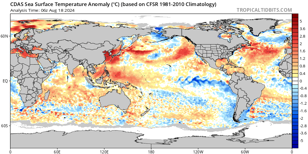
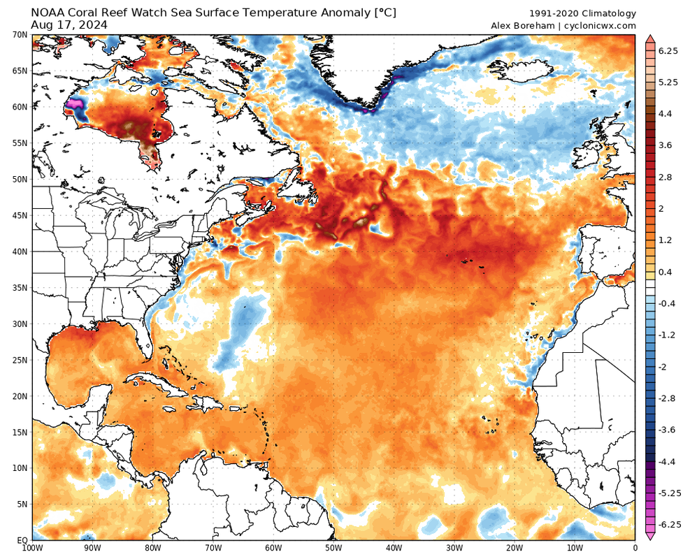
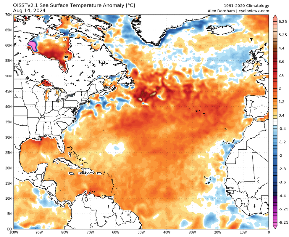
https://i.postimg.cc/NFHxYMQt/cdas-sflux-ssta-global-1.png
CDAS has a well-known cold bias if there's SAL in the Atlantic. Coral Reef Watch and OISST are more robust to that, and paint a different picture:
2 likes
TC naming lists: retirements and intensity
Most aggressive Advisory #1's in North Atlantic (cr. kevin for starting the list)
Most aggressive Advisory #1's in North Atlantic (cr. kevin for starting the list)
-
Category5Kaiju
- Category 5
- Posts: 4330
- Joined: Thu Dec 24, 2020 12:45 pm
- Location: Seattle and Phoenix
Re: 2024 Indicators: SST's, MSLP, Shear, SAL, Steering, Instability (Day 16+ Climate Models)
Regardless of what's being talked about on other platforms and elsewhere here, I still can't shake off the fact that we had a Category 4 hurricane in the MDR in June, as well as the earliest Category 5 on record and with that storm ending up as a long-lived, Cape Verde hurricane. Of all the hurricane seasons I've personally tracked, this season, or so I would've thought at least, would be the least vulnerable to canceling 
I'll pose this question: "do you honestly think Beryl happened for no reason or that it doesn't mean anything about this season's future potential?"
I'll pose this question: "do you honestly think Beryl happened for no reason or that it doesn't mean anything about this season's future potential?"
4 likes
Unless explicitly stated, all info in my posts is based on my own opinions and observations. Tropical storms and hurricanes can be extremely dangerous. Refer to an accredited weather research agency or meteorologist if you need to make serious decisions regarding an approaching storm.
-
toad strangler

- S2K Supporter
- Posts: 4546
- Joined: Sun Jul 28, 2013 3:09 pm
- Location: Earth
- Contact:
Re: 2024 Indicators: SST's, MSLP, Shear, SAL, Steering, Instability (Day 16+ Climate Models)
WOW Teban54 the Junkyard DOG lol
Also, Cat5Kaiju, I’m with you. I fully support the notion that the incredible anomaly that was Beryl is a harbinger of future events. As CSU believes. Number of storms isn't on my priority list.
Also, Cat5Kaiju, I’m with you. I fully support the notion that the incredible anomaly that was Beryl is a harbinger of future events. As CSU believes. Number of storms isn't on my priority list.
2 likes
My Weather Station
https://www.wunderground.com/dashboard/pws/KFLPORTS603
https://www.wunderground.com/dashboard/pws/KFLPORTS603
-
skyline385
- Category 5
- Posts: 2728
- Age: 35
- Joined: Wed Aug 26, 2020 11:15 pm
- Location: Houston TX
Re: 2024 Indicators: SST's, MSLP, Shear, SAL, Steering, Instability (Day 16+ Climate Models)
Teban54 wrote:Since the 2017 comparison has come up a lot in the discussions, I went back and quoted some (season cancel or borderline season cancel) comments from the 2017 indicators thread, between August 1 and August 30 when Irma formed.
Scroll down to August 16 if you want a shorter read; the peak season canceling occurred on August 19. (More stuff could be found by just extending the time frame to July 30, but I chose not to.)
We really go through these motions every year, don't we? Even the dates line up perfectly and that too in a year like 2024 with the earliest C5 on record.
4 likes

Re: 2024 Indicators: SST's, MSLP, Shear, SAL, Steering, Instability (Day 16+ Climate Models)
Not sure if this was mentioned. There is an impressive wave/spin about to roll off the COA by tomorrow..
It's just a matter days not weeks for the real season to begin. IMO..
It's just a matter days not weeks for the real season to begin. IMO..
0 likes
Re: 2024 Indicators: SST's, MSLP, Shear, SAL, Steering, Instability (Day 16+ Climate Models)
I made a comparison chart of the SST anomalies on August 17 of every season that reached NOAA's "extremely active" threshold of 159.6 in the modern +AMO era, together with 2024.
Full-res version is on postimg.cc: https://postimg.cc/1ndc1kVR
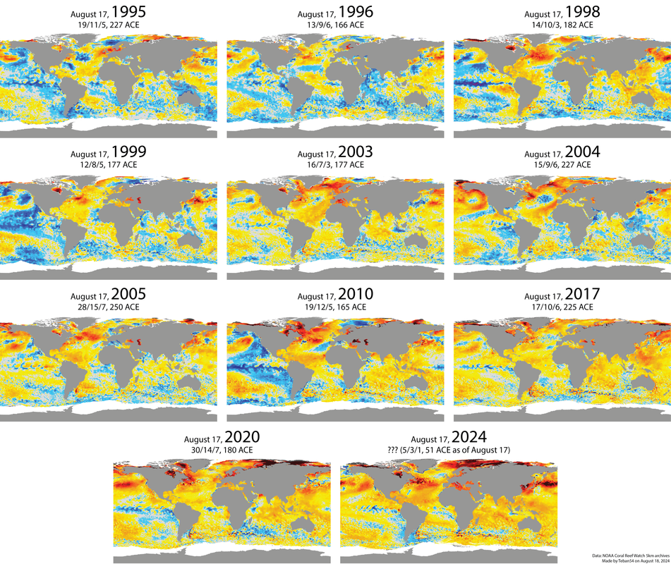
Full-res version is on postimg.cc: https://postimg.cc/1ndc1kVR
4 likes
TC naming lists: retirements and intensity
Most aggressive Advisory #1's in North Atlantic (cr. kevin for starting the list)
Most aggressive Advisory #1's in North Atlantic (cr. kevin for starting the list)
-
weeniepatrol
- Category 5
- Posts: 1340
- Joined: Sat Aug 22, 2020 5:30 pm
- Location: WA State
Re: 2024 Indicators: SST's, MSLP, Shear, SAL, Steering, Instability (Day 16+ Climate Models)
Teban54 wrote:A post so comprehensive that it borders on absurd
Incredible, could not have done it better myself. Tracking the Atlantic hurricane season is like tracking the stock market. The psychological similarities are shocking. What we've got right now is a classic bear trap.. it's 18 August not 18 September.

Never you mind that the Atlantic STILL has more ACE than the West Pacific and over 3x the ACE of the East Pacific, all during the least active part of the Atlantic season
BTW all we have to do is follow climatology from todays' date, and this season is hyperactive
Last edited by weeniepatrol on Sun Aug 18, 2024 1:15 pm, edited 1 time in total.
2 likes
-
CyclonicFury

- Category 5
- Posts: 2032
- Age: 27
- Joined: Sun Jul 02, 2017 12:32 pm
- Location: NC
- Contact:
Re: 2024 Indicators: SST's, MSLP, Shear, SAL, Steering, Instability (Day 16+ Climate Models)
Overall, when looking at large scale conditions, it does not appear the Atlantic has been unusually unfavorable by any metric. Shear has been below normal across the deep tropics (though this graphic uses an older climo period), precipitable water has been well above average across the entire basin, and surface pressures have been below normal in the tropical Atlantic and Caribbean. Even mid-level RH has been above normal across most of the tropical Atlantic and Caribbean. Even though the models don't show much yet, I still believe a significant uptick is coming for the MDR, just not this week. "Season canceling" would make more sense if we hadn't already seen 2 hurricanes this month, after many recent seasons had nothing in the first half of August. The "switch flip" is often more gradual, and the MDR doesn't just instantly start producing constant Cape Verde type majors once August 20 arrives.


3 likes
NCSU B.S. in Meteorology Class of 2021. Tropical weather blogger at http://www.cyclonicfury.com. My forecasts and thoughts are NOT official, for official forecasts please consult the National Hurricane Center.
-
SFLcane

- S2K Supporter
- Posts: 10281
- Age: 48
- Joined: Sat Jun 05, 2010 1:44 pm
- Location: Lake Worth Florida
Re: 2024 Indicators: SST's, MSLP, Shear, SAL, Steering, Instability (Day 16+ Climate Models)
Teban54 wrote:I made a comparison chart of the SST anomalies on August 17 of every season that reached NOAA's "extremely active" threshold of 159.6 in the modern +AMO era, together with 2024.
Full-res version is on postimg.cc: https://postimg.cc/1ndc1kVR
https://i.postimg.cc/PJX6YhtD/Hyperactive-seasons-SSTA-August-17.png
The only 3 years on 8/17 that show the current high latitude warming from what i can tell is 1998 and 2005 we still managed to squeeze out 10+ hurricanes. You can also throw 2010 into that mix i guess.
0 likes
-
SFLcane
- S2K Supporter
- Posts: 10281
- Age: 48
- Joined: Sat Jun 05, 2010 1:44 pm
- Location: Lake Worth Florida
Re: 2024 Indicators: SST's, MSLP, Shear, SAL, Steering, Instability (Day 16+ Climate Models)
CyclonicFury wrote:Overall, when looking at large scale conditions, it does not appear the Atlantic has been unusually unfavorable by any metric. Shear has been below normal across the deep tropics (though this graphic uses an older climo period), precipitable water has been well above average across the entire basin, and surface pressures have been below normal in the tropical Atlantic and Caribbean. Even mid-level RH has been above normal across most of the tropical Atlantic and Caribbean. Even though the models don't show much yet, I still believe a significant uptick is coming for the MDR, just not this week. "Season canceling" would make more sense if we hadn't already seen 2 hurricanes this month, after many recent seasons had nothing in the first half of August. The "switch flip" is often more gradual, and the MDR doesn't just instantly start producing constant Cape Verde type majors once August 20 arrives.
https://i.ibb.co/yXpDgYP/IMG-1464.gif
https://i.ibb.co/1bWTsRW/IMG-1467.gif
https://i.ibb.co/4NVryM0/IMG-1466.gif
https://i.ibb.co/5MP5s45/IMG-1465.gif
1 likes
-
weeniepatrol
- Category 5
- Posts: 1340
- Joined: Sat Aug 22, 2020 5:30 pm
- Location: WA State
Re: 2024 Indicators: SST's, MSLP, Shear, SAL, Steering, Instability (Day 16+ Climate Models)
Also, assuming Ernesto dies immediately and produces no more ACE, with no more systems afterwards. It would take until September 8th.. three WEEKS out.. for us to fall behind climatology
1 likes

Re: 2024 Indicators: SST's, MSLP, Shear, SAL, Steering, Instability (Day 16+ Climate Models)
Category5Kaiju wrote:Regardless of what's being talked about on other platforms and elsewhere here, I still can't shake off the fact that we had a Category 4 hurricane in the MDR in June, as well as the earliest Category 5 on record and with that storm ending up as a long-lived, Cape Verde hurricane. Of all the hurricane seasons I've personally tracked, this season, or so I would've thought at least, would be the least vulnerable to canceling
I'll pose this question: "do you honestly think Beryl happened for no reason or that it doesn't mean anything about this season's future potential?"
It could have. Weather is complete chaos, it doesn’t follow rules and analogues perfectly. I remember back in 2021 when Elsa formed, the only seasons that a hurricane had formed that early where Elsa did were hyperactive years but 2021 didn’t end up being hyperactive, breaking that mold. Not saying that will for sure happen this year, but I certainly wouldn’t say Beryl guarantees anything because nothing in weather is guaranteed.
0 likes
Who is online
Users browsing this forum: Google Adsense [Bot], ljmac75 and 150 guests