2024 Global Model Runs Discussion (Out thru day 16)

This is the general tropical discussion area. Anyone can take their shot at predicting a storms path.

Moderator: S2k Moderators

Forum rules

The posts in this forum are NOT official forecasts and should not be used as such. They are just the opinion of the poster and may or may not be backed by sound meteorological data. They are NOT endorsed by any professional institution or STORM2K. For official information, please refer to products from the National Hurricane Center and National Weather Service.

Help Support Storm2K
Message
Author
TomballEd
Category 2
Category 2
Posts: 694
Age: 61
Joined: Wed Aug 16, 2023 4:52 pm
Location: Spring/Klein area, not Tomball

Re: 2024 Global Model Runs Discussion (Out thru day 16)

#1101 Postby TomballEd » Tue Aug 20, 2024 5:00 pm

I seem to be blocked at work for signing up for the image. The Op GFS and Op Euro and ensembles have similar solutions at 10 days, a strong trough over the North East US which would recurve anything approaching from the MDR.

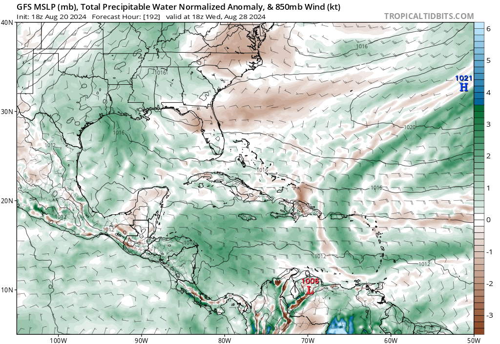
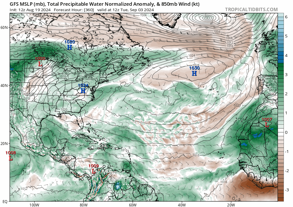
The ensembles are not identical at 300 hours, but are kind of close, the STR on GEFS reaches to near the Bahamas, which puts potentially the E GOMEX, Florida and ECUSA at some level of risk, Euro ensembles bridge the ridge between the Azores-Bermuda and Sonoran ridges, with a col, a weakness, in the E GOMEX which would favor landfalls there. The ECENS have some members with TCs in the area.

People thought I was too harsh on August, but starting about Labor Day, I could see TV=C threats from Mobile to the Carolinas. Euro weeklies go from well below normal climatological ACE last week of August to near/barely eblow normal ACE through mid-September. Euro weekly TC probs have a juicy looking week for NY/New England with >10% TS w/i 300 km probs reaching the coast the week of September 9. 5 days beyond the range of the Euro or GFS ensembles, but intriguing and there is finally a signal for activity after 10 days.

Image
1 likes   

User avatar
aspen
Category 5
Category 5
Posts: 8818
Joined: Sat Oct 12, 2019 7:10 pm
Location: Connecticut, USA

Re: 2024 Global Model Runs Discussion (Out thru day 16)

#1102 Postby aspen » Tue Aug 20, 2024 6:07 pm

Forget what I said earlier today about the models lighting up again lol. All other operational GFS/Euro runs today haven’t shown the TCs they did this morning.
1 likes   
Irene '11 Sandy '12 Hermine '16 5/15/2018 Derecho Fay '20 Isaias '20 Elsa '21 Henri '21 Ida '21

I am only a meteorology enthusiast who knows a decent amount about tropical cyclones. Look to the professional mets, the NHC, or your local weather office for the best information.

User avatar
Hammy
Category 5
Category 5
Posts: 5849
Age: 41
Joined: Fri May 25, 2012 5:25 pm
Contact:

Re: 2024 Global Model Runs Discussion (Out thru day 16)

#1103 Postby Hammy » Tue Aug 20, 2024 6:10 pm

Is it too much to ask for some model consistency? Just when it looks like we're seeing a trend they all flip back to "nope nothing to see"
1 likes   
The above post is not official and should not be used as such. It is the opinion of the poster and may or may not be backed by sound meteorological data. It is not endorsed by any professional institution or storm2k.org. For official information, please refer to the NHC and NWS products.

Stratton23
Category 5
Category 5
Posts: 2519
Joined: Fri Jul 21, 2023 10:59 pm
Location: Katy, Tx

Re: 2024 Global Model Runs Discussion (Out thru day 16)

#1104 Postby Stratton23 » Tue Aug 20, 2024 6:12 pm

Hammy thats the problem with a flip to an active pattern, the global models are typically going to struggle mightily with that, which is why its been back and forth on some models, will say though ensembles and especially the EPS, have been pretty consistent with showing things getting active, but yeah i get it, the flip flopping can be incredibly annoying
2 likes   

User avatar
Blown Away
S2K Supporter
S2K Supporter
Posts: 10145
Joined: Wed May 26, 2004 6:17 am

Re: 2024 Global Model Runs Discussion (Out thru day 16)

#1105 Postby Blown Away » Tue Aug 20, 2024 6:15 pm

aspen wrote:Forget what I said earlier today about the models lighting up again lol. All other operational GFS/Euro runs today haven’t shown the TCs they did this morning.


I do remember many years mid August the globals not showing much into late August, but now the long range models are getting close to peak season in September and nearly nothing in the MDR. I know the ensembles showing some activity, but nothing overwhelming… It’s a bit unusual IMO…
1 likes   
Hurricane Eye Experience: David 79, Irene 99, Frances 04, Jeanne 04, Wilma 05... EYE COMING MY WAY IN 2024…
Hurricane Brush Experience: Andrew 92, Erin 95, Floyd 99, Matthew 16, Irma 17, Ian 22, Nicole 22…

Stratton23
Category 5
Category 5
Posts: 2519
Joined: Fri Jul 21, 2023 10:59 pm
Location: Katy, Tx

Re: 2024 Global Model Runs Discussion (Out thru day 16)

#1106 Postby Stratton23 » Tue Aug 20, 2024 6:24 pm

I personally do not think the signal has to be incredibly high to indicate an active switch, the ensembles have a pretty good signal, either way, make sure you have all youre plans set in place, because im willing to bet that the SE US and Gulf coasts will have a couple of really close calls or big threats down the road, all that available upper ocean heat content, its just a matter of time before a wave takes advantage of that, and then then the models really see it, and thats my biggest concern, the models not seeing something until its already developing, its happened before
4 likes   

LarryWx
S2K Supporter
S2K Supporter
Posts: 6305
Joined: Sun Sep 07, 2003 2:04 pm
Location: GA

Re: 2024 Global Model Runs Discussion (Out thru day 16)

#1107 Postby LarryWx » Tue Aug 20, 2024 6:50 pm

Fwiw for the 5th run in a row, the Euro AI has a TC threatening Luis/PR on Sept 3. Any thoughts?
1 likes   
Personal Forecast Disclaimer:
The posts in this forum are NOT official forecasts and should not be used as such. They are just the opinion of the poster and may or may not be backed by sound meteorological data. They are NOT endorsed by any professional institution or storm2k.org. For official information, please refer to the NHC and NWS products.

User avatar
Hammy
Category 5
Category 5
Posts: 5849
Age: 41
Joined: Fri May 25, 2012 5:25 pm
Contact:

Re: 2024 Global Model Runs Discussion (Out thru day 16)

#1108 Postby Hammy » Tue Aug 20, 2024 6:54 pm

LarryWx wrote:Fwiw for the 5th run in a row, the Euro AI has a TC threatening Luis/PR on Sept 3. Any thoughts?


Really wish we had a higher resolution version/more options (700-300mb humidity and PWAT are good to use to look beyond the surface winds, since that doesn't show organization very well on the wider map) since it seems like the only one that's being consistent
1 likes   
The above post is not official and should not be used as such. It is the opinion of the poster and may or may not be backed by sound meteorological data. It is not endorsed by any professional institution or storm2k.org. For official information, please refer to the NHC and NWS products.

User avatar
Teban54
Category 5
Category 5
Posts: 3204
Joined: Sat May 19, 2018 1:19 pm

Re: 2024 Global Model Runs Discussion (Out thru day 16)

#1109 Postby Teban54 » Tue Aug 20, 2024 6:57 pm

LarryWx wrote:Fwiw for the 5th run in a row, the Euro AI has a TC threatening Luis/PR on Sept 3. Any thoughts?

Obviously nobody knows the track record of Euro AI yet, but I recall there was one point in July (?) when it and another model were the only ones showing a MDR TC that didn't verify.
1 likes   

User avatar
weeniepatrol
Category 5
Category 5
Posts: 1273
Joined: Sat Aug 22, 2020 5:30 pm
Location: WA State

Re: 2024 Global Model Runs Discussion (Out thru day 16)

#1110 Postby weeniepatrol » Tue Aug 20, 2024 6:57 pm

12z GEFS, hour 240

Image

18z GEFS, hour 210

Image
1 likes   

User avatar
Ubuntwo
Category 5
Category 5
Posts: 1406
Age: 31
Joined: Thu Oct 05, 2017 10:41 pm

Re: 2024 Global Model Runs Discussion (Out thru day 16)

#1111 Postby Ubuntwo » Tue Aug 20, 2024 7:02 pm

Teban54 wrote:
LarryWx wrote:Fwiw for the 5th run in a row, the Euro AI has a TC threatening Luis/PR on Sept 3. Any thoughts?

Obviously nobody knows the track record of Euro AI yet, but I recall there was one point in July (?) when it and another model were the only ones showing a MDR TC that didn't verify.

It was (for what it's worth) the first model to pick up on Ernesto.
2 likes   
Kendall -> SLO -> PBC

Memorable Storms: Katrina (for its Florida landfall...) Wilma Matthew Irma

User avatar
Teban54
Category 5
Category 5
Posts: 3204
Joined: Sat May 19, 2018 1:19 pm

Re: 2024 Global Model Runs Discussion (Out thru day 16)

#1112 Postby Teban54 » Tue Aug 20, 2024 7:10 pm

weeniepatrol wrote:12z GEFS, hour 240

https://i.imgur.com/wrEgOmf.png

18z GEFS, hour 210

https://i.imgur.com/zsagQa1.png

While it does look like 18z GEFS is considerably more active than 12z, it still lags behind 0z and 6z slightly (at least for the first 240 hours or so that weathernerds has loaded). Given the changes in operational runs though, that's not surprising.

Edit to add:
Hammy wrote:Is it too much to ask for some model consistency? Just when it looks like we're seeing a trend they all flip back to "nope nothing to see"

I guess one way to look at it is... If 30-50% of ensemble members are showing development (which is my estimate based on eyeballing), it makes sense for operational models to only show development 30-50% of the time.
1 likes   

User avatar
REDHurricane
Category 1
Category 1
Posts: 396
Age: 27
Joined: Sun Jul 03, 2022 2:36 pm
Location: Northeast Pacific Ocean

Re: 2024 Global Model Runs Discussion (Out thru day 16)

#1113 Postby REDHurricane » Tue Aug 20, 2024 9:13 pm

Stratton23 wrote:ICON and Euro both show some slight development of the mid level disturbance that crosses the gulf next week, as the energy pinches off from the trough and moves into the gulf, the ICON and Euro models do attempt to tighten up the vorticity signature just a bit, while most guidance really doesnt show development, it will be crossing over the hottest part of the gulf as it moves west towards texas, has 2-2.5 days over water, worth watching as upper lows over the gulf can be very tricky and sometimes develop even when models dont expect it


ICON in particular always seems to have more success with sniffing out some of these Gulf systems before the other models do; it's definitely happened several times over the past few years though my brain is too tired right now to remember/look up which specific storms they were, but uh yeah just trust me bro it's the real truth. Regardless of what the other models say, I'll be paying close attention to how ICON is trending in the Gulf over the next few days... probably nothing will come of it and a cutoff low likely wouldn't be able to intensify quickly enough (even in the 32ºC Gulf) to create a serious wind threat before landfall anyway, but again you never know until it's already happening
0 likes   

User avatar
Teban54
Category 5
Category 5
Posts: 3204
Joined: Sat May 19, 2018 1:19 pm

Re: 2024 Global Model Runs Discussion (Out thru day 16)

#1114 Postby Teban54 » Tue Aug 20, 2024 9:32 pm

REDHurricane wrote:
Stratton23 wrote:ICON and Euro both show some slight development of the mid level disturbance that crosses the gulf next week, as the energy pinches off from the trough and moves into the gulf, the ICON and Euro models do attempt to tighten up the vorticity signature just a bit, while most guidance really doesnt show development, it will be crossing over the hottest part of the gulf as it moves west towards texas, has 2-2.5 days over water, worth watching as upper lows over the gulf can be very tricky and sometimes develop even when models dont expect it


ICON in particular always seems to have more success with sniffing out some of these Gulf systems before the other models do; it's definitely happened several times over the past few years though my brain is too tired right now to remember/look up which specific storms they were, but uh yeah just trust me bro it's the real truth. Regardless of what the other models say, I'll be paying close attention to how ICON is trending in the Gulf over the next few days... probably nothing will come of it and a cutoff low likely wouldn't be able to intensify quickly enough (even in the 32ºC Gulf) to create a serious wind threat before landfall anyway, but again you never know until it's already happening

Actually, looks like 18z GFS also showed some hints of the Gulf system, albeit far from a bonafide TC:

Image

Image
0 likes   

Stratton23
Category 5
Category 5
Posts: 2519
Joined: Fri Jul 21, 2023 10:59 pm
Location: Katy, Tx

Re: 2024 Global Model Runs Discussion (Out thru day 16)

#1115 Postby Stratton23 » Tue Aug 20, 2024 9:38 pm

Teban54 yeah just a wave axis on that GFS run, but notice it has a good moisture pool, ive seen a lot of crazy things happen in the gulf , and i wouldnt at all be surprised if we see a sneaky spin up as the low approaches the texas coastline, that would really help to bring in a good surge of tropical moisture into the reguon
0 likes   

User avatar
Hybridstorm_November2001
S2K Supporter
S2K Supporter
Posts: 2811
Joined: Sat Aug 21, 2004 2:50 pm
Location: SW New Brunswick, Canada
Contact:

Re: 2024 Global Model Runs Discussion (Out thru day 16)

#1116 Postby Hybridstorm_November2001 » Tue Aug 20, 2024 9:56 pm

aspen wrote:Forget what I said earlier today about the models lighting up again lol. All other operational GFS/Euro runs today haven’t shown the TCs they did this morning.


I think my prediction of a near record or record season was a mistake, live and learn. :spam:
0 likes   

User avatar
Teban54
Category 5
Category 5
Posts: 3204
Joined: Sat May 19, 2018 1:19 pm

Re: 2024 Global Model Runs Discussion (Out thru day 16)

#1117 Postby Teban54 » Tue Aug 20, 2024 10:28 pm

:lol:
Image

Edit: Intriguingly, 0z ICON keeps this system alive till the end of this run, far longer than any earlier runs. The main reason is that it stays much further south, and even dives SW down to 10N. Again, no other models currently show this, so it's unlikely to materialize -- but still interesting to see.

Image
0 likes   

User avatar
Category5Kaiju
Category 5
Category 5
Posts: 4097
Joined: Thu Dec 24, 2020 12:45 pm
Location: Seattle

Re: 2024 Global Model Runs Discussion (Out thru day 16)

#1118 Postby Category5Kaiju » Tue Aug 20, 2024 11:19 pm

The recent 0z and 12z Euro ensembles have floated the idea of an MDR system forming by the month's end, heading westward. We'll wait and see what the upcoming 0z ensembles say for that, but the recent Euro ensembles have been pretty good at sniffing out storms this season (Beryl, Debby, and Ernesto in mind). If I had to bet on using one model as a good resource for mid to long range genesis detection, those are probably my go-to.
1 likes   
Unless explicitly stated, all info in my posts is based on my own opinions and observations. Tropical storms and hurricanes can be extremely dangerous. Do not think you can beat Mother Nature. Refer to an accredited weather research agency or meteorologist if you need to make serious decisions regarding an approaching storm.

Stratton23
Category 5
Category 5
Posts: 2519
Joined: Fri Jul 21, 2023 10:59 pm
Location: Katy, Tx

Re: 2024 Global Model Runs Discussion (Out thru day 16)

#1119 Postby Stratton23 » Tue Aug 20, 2024 11:38 pm

And the operational globals models struggles continue, everything is strung out again on these runs, its a safe bet to say they are lost, eventually they will catch on to a wave. but for right now they are definitely lost
0 likes   

User avatar
Teban54
Category 5
Category 5
Posts: 3204
Joined: Sat May 19, 2018 1:19 pm

Re: 2024 Global Model Runs Discussion (Out thru day 16)

#1120 Postby Teban54 » Wed Aug 21, 2024 12:33 am

Stratton23 wrote:And the operational globals models struggles continue, everything is strung out again on these runs, its a safe bet to say they are lost, eventually they will catch on to a wave. but for right now they are definitely lost

For one, GFS is depicting completely different solutions in the extratropics every run, unsurprisingly. I have to wonder how much of that end up having downstream effects on the tropics, and whether that's contributing to the flip-flopping of development.

Trend GIF specifically selected for maximum drama: (Focus on around 40N)

Image
1 likes   


Return to “Talkin' Tropics”

Who is online

Users browsing this forum: Google Adsense [Bot] and 34 guests