EPAC: GILMA - Post-Tropical - Discussion

Moderator: S2k Moderators

Message
Author
User avatar
Yellow Evan
Professional-Met
Professional-Met
Posts: 16058
Age: 26
Joined: Fri Jul 15, 2011 12:48 pm
Location: Henderson, Nevada/Honolulu, HI
Contact:

Re: EPAC: GILMA - Tropical Storm - Discussion

#41 Postby Yellow Evan » Wed Aug 21, 2024 2:01 am

Image


Image


Image

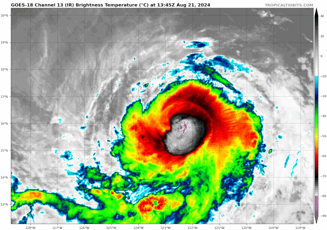
Despite moderate wind shear, we are quickly seeing the classical evolution atypical RI evolution with following pulsating convection and a significant vertical tilt. Typically once we see rotating, an eye clears in about ~36 hours, although convective asymmetries are often present at clearing.
1 likes   

User avatar
Yellow Evan
Professional-Met
Professional-Met
Posts: 16058
Age: 26
Joined: Fri Jul 15, 2011 12:48 pm
Location: Henderson, Nevada/Honolulu, HI
Contact:

Re: EPAC: GILMA - Tropical Storm - Discussion

#42 Postby Yellow Evan » Wed Aug 21, 2024 2:03 am

EP, 07, 2024082106, , BEST, 0, 159N, 1220W, 65, 990, HU, 64, NEQ, 20, 20, 0, 0, 1011, 190, 20, 0, 0, E, 0, , 0, 0, GILMA, D, 0, , 0, 0, 0, 0, genesis-num, 018,
0 likes   

User avatar
Yellow Evan
Professional-Met
Professional-Met
Posts: 16058
Age: 26
Joined: Fri Jul 15, 2011 12:48 pm
Location: Henderson, Nevada/Honolulu, HI
Contact:

Re: EPAC: GILMA - Tropical Storm - Discussion

#43 Postby Yellow Evan » Wed Aug 21, 2024 2:07 am

TXPZ28 KNES 210627
TCSENP

A. 07E (GILMA)

B. 21/0601Z

C. 16.1N

D. 122.3W

E. THREE/GOES-W

F. T4.0/4.0

G. IR/EIR/SWIR

H. REMARKS...11/10 BANDING RESULTS IN A DT OF 4.0. THE MET AND PT AGREE
BASED ON A RAPID DEVELOPMENT TREND OVER THE PAST 24 HOURS. THE FT IS
BASED ON THE DT.

I. ADDL POSITIONS

NIL


...COVERDALE
0 likes   

User avatar
Yellow Evan
Professional-Met
Professional-Met
Posts: 16058
Age: 26
Joined: Fri Jul 15, 2011 12:48 pm
Location: Henderson, Nevada/Honolulu, HI
Contact:

Re: EPAC: GILMA - Tropical Storm - Discussion

#44 Postby Yellow Evan » Wed Aug 21, 2024 3:54 am

695
WTPZ42 KNHC 210849
TCDEP2

Hurricane Gilma Discussion Number 12
NWS National Hurricane Center Miami FL EP072024
200 AM PDT Wed Aug 21 2024

Satellite images showed Gilma becoming better organized through the
night until about 0700 UTC, with the low-level center embedded
underneath the deep convection. A 21/0216 SSMIS pass was quite
helpful showing a more impressive mid-level structure, with the
low-level center likely located about 20 miles to the northwest of
the mid-level center. The latest images since 0700 UTC show a dry
slot in between the central convective mass and a curved band to the
northwest of the center. GOES-West CIRA Proxy-Vis imagery has been
hinting that the low-level center may be near the NW edge of the
central convective area rather than under the middle of it. The
latest subjective intensity estimates were T-4.0/65 kt from both
TAFB and SAB, and the latest objective intensity estimates from
UW-CIMSS range from 61-68 kt. Based on these subjective and
objective intensity estimates, the initial intensity is bumped up to
65 kt, making Gilma the second hurricane of the 2024 East Pacific
hurricane season.

Gilma has been moving due west over the past 12 h at 270/9 kt. A
mid- to upper-level ridge situated to the north of the cyclone
should be the primary steering mechanism through the forecast
period, taking Gilma on a westward to west-northwestward course. A
broad upper-level trough is forecast to move in well north of Gilma
Thursday into Friday, which should act to slow Gilma's forward speed
a bit. The latest global models indicate that this trough won't
have much of an influence on causing Gilma to gain latitude. As a
result, the track guidance has continued to shift well to the south,
showing a mostly westward track through the forecast period. The
latest NHC forecast has been shifted south of the previous official
forecast, but still lies closer to the previous official forecast
than the latest model consensus. If this trend continues, then
subsequent NHC forecasts will need to be adjusted southward.

Gilma has been reorganizing structurally as it has gradually to
steadily strengthened over the past 24 h. Upper-level winds are
expected to become more favorable over the next day or so. Gilma
should remain over relatively warm SSTs and within a moist enough
airmass for the next 24 to 48 h to allow for additional steady
intensification, and the forecast peak intensity remains 90 kt. By
the weekend, Gilma should encounter gradually cooling sea surface
temperatures and drier mid-level air, causing the cyclone to
gradually weaken. Only minor changes were made to the official
intensity forecast. The intensity forecast is slightly above the
model consensus during the short term, and near the consensus
during the latter portion of the forecast period.


FORECAST POSITIONS AND MAX WINDS

INIT 21/0900Z 16.0N 122.3W 65 KT 75 MPH
12H 21/1800Z 16.1N 123.3W 70 KT 80 MPH
24H 22/0600Z 16.5N 124.4W 80 KT 90 MPH
36H 22/1800Z 16.9N 125.6W 90 KT 105 MPH
48H 23/0600Z 17.2N 126.7W 90 KT 105 MPH
60H 23/1800Z 17.5N 128.1W 90 KT 105 MPH
72H 24/0600Z 17.7N 129.6W 85 KT 100 MPH
96H 25/0600Z 18.3N 132.8W 70 KT 80 MPH
120H 26/0600Z 19.1N 136.7W 60 KT 70 MPH

$$
Forecaster Hagen/Pasch
0 likes   

User avatar
aspen
Category 5
Category 5
Posts: 8812
Joined: Sat Oct 12, 2019 7:10 pm
Location: Connecticut, USA

Re: EPAC: GILMA - Hurricane - Discussion

#45 Postby aspen » Wed Aug 21, 2024 7:13 am

Starting to see convection wrap around and an eye pop out, right on time according to yesterday’s hurricane model runs. It’ll probably look fairly rough until tomorrow, maybe early Friday at the latest.
0 likes   
Irene '11 Sandy '12 Hermine '16 5/15/2018 Derecho Fay '20 Isaias '20 Elsa '21 Henri '21 Ida '21

I am only a meteorology enthusiast who knows a decent amount about tropical cyclones. Look to the professional mets, the NHC, or your local weather office for the best information.

User avatar
cycloneye
Admin
Admin
Posts: 143866
Age: 68
Joined: Thu Oct 10, 2002 10:54 am
Location: San Juan, Puerto Rico

Re: EPAC: GILMA - Hurricane - Discussion

#46 Postby cycloneye » Wed Aug 21, 2024 9:45 am

Now forecast to become a cat 3.

Hurricane Gilma Discussion Number 13
NWS National Hurricane Center Miami FL EP072024
800 AM PDT Wed Aug 21 2024

This morning, Gilma's structure on satellite has continued to
improve, with infrared satellite depicting a banding type eye
appearing intermittently as convection attempts to wrap around the
estimated center. In addition, we received a 0933 UTC AMSR2
microwave pass which showed a developing eyewall on both the 89-GHz
and 37-GHz channels, though with some vertical tilt. The latest
subjective Dvorak intensity estimates from TAFB and SAB were both
T4.5/77-kt, which also matches the latest ADT estimate. Thus,
Gilma's initial intensity will be raised to 75 kt for this
advisory.

Gilma appears to be moving just north of due west, but slower than
earlier, estimated at 280/6 kt. Over the next few days, a large
subtropical ridge poleward of the hurricane should continue to steer
it generally westward to west-northwestward. However, this ridge
becomes positioned a little farther northwest with time as a subtle
weakness north of the storm forms, resulting in a
slower-than-typical forward motion for this part of the Eastern
Pacific basin. The latest track guidance this cycle is notably
slower and more equatorward than the previous cycle, and the NHC
track was shifted in that direction, but not quite as far as the
reliable track consensus guidance TVCE and HCCA. As mentioned in the
previous discussion, if these southward trends continue, further
southward adjustments may be necessary.

With the improvement of Gilma's inner core structure this morning,
the hurricane may be poised to intensify more over the next day or
two. This scenario is shown by the recent hurricane-regional model
guidance, which shows more intensification than the prior cycle.
Given the reduction in vertical wind shear noted in the recent SHIPS
guidance and as Gilma remains over 27-28 C sea-surface temperatures
for the next 48 h, the NHC intensity forecast now shows
intensification into a Category 3 hurricane over this time period.
This intensity forecast is higher than the previous one, but is in
good agreement with the latest HCCA consensus aid. However there
remain some hurricane-regional models that show even more
intensification (e.g., HAFS-A). After 48 h, sea-surface temperatures
begin to gradually decrease, and slow weakening is expected to begin
thereafter, though less than the previous advisory due to the
further south track over warmer ocean waters.


FORECAST POSITIONS AND MAX WINDS

INIT 21/1500Z 16.0N 122.8W 75 KT 85 MPH
12H 22/0000Z 16.2N 123.7W 85 KT 100 MPH
24H 22/1200Z 16.5N 124.8W 95 KT 110 MPH
36H 23/0000Z 16.8N 125.9W 100 KT 115 MPH
48H 23/1200Z 16.9N 127.2W 100 KT 115 MPH
60H 24/0000Z 17.1N 128.5W 95 KT 110 MPH
72H 24/1200Z 17.3N 130.3W 90 KT 105 MPH
96H 25/1200Z 17.5N 133.5W 85 KT 100 MPH
120H 26/1200Z 18.0N 137.5W 70 KT 80 MPH

$$
Forecaster Papin/Alaka
1 likes   
Visit the Caribbean-Central America Weather Thread where you can find at first post web cams,radars
and observations from Caribbean basin members Click Here

User avatar
Hurricane2022
Category 5
Category 5
Posts: 1496
Joined: Tue Aug 23, 2022 11:38 pm
Location: Araçatuba, Brazil

Re: EPAC: GILMA - Hurricane - Discussion

#47 Postby Hurricane2022 » Wed Aug 21, 2024 11:40 am

I wouldn't be surprised if this reaches C4 in the next few days. Looking fairly good now.
Image
Image
2 likes   
Sorry for the bad English sometimes...!
For reliable and detailed information for any meteorological phenomenon, please consult the National Hurricane Center, Joint Typhoon Warning Center , or your local Meteo Center.

--------

Una cvm Christo, pro Christo, et in Christo. Sit nomen Domini benedictvm.

User avatar
Kingarabian
S2K Supporter
S2K Supporter
Posts: 15827
Joined: Sat Aug 08, 2009 3:06 am
Location: Honolulu, Hawaii

Re: EPAC: GILMA - Hurricane - Discussion

#48 Postby Kingarabian » Wed Aug 21, 2024 11:41 am

Hurricane2022 wrote:I wouldn't be surprised if this reaches C4 in the next few days. Looking fairly good now.
https://imageshack.com/i/pn9jFJG0j
https://imageshack.com/i/poOoNq4Zj

Looks like it's getting ready to enter donut mode. Very little banding in the northern quads.
0 likes   
RIP Kobe Bryant

User avatar
xtyphooncyclonex
Category 5
Category 5
Posts: 3857
Age: 23
Joined: Sat Dec 08, 2012 9:07 am
Location: Cebu City
Contact:

Re: EPAC: GILMA - Hurricane - Discussion

#49 Postby xtyphooncyclonex » Wed Aug 21, 2024 11:57 am

Gilma is now a whole 20 knots stronger than yesterday's forecast for this bulletin. Wouldn't be surprised if we wake up to a category four in two days. Models are heavily picking up on her, and its structure seems ready for takeoff. Being annular could help Gilma hold onto its intensity for longer.
0 likes   
REMINDER: My opinions that I, or any other NON Pro-Met in this forum, are unofficial. Please do not take my opinions as an official forecast and warning. I am NOT a meteorologist. Following my forecasts blindly may lead to false alarm, danger and risk if official forecasts from agencies are ignored.

User avatar
Kingarabian
S2K Supporter
S2K Supporter
Posts: 15827
Joined: Sat Aug 08, 2009 3:06 am
Location: Honolulu, Hawaii

Re: EPAC: GILMA - Hurricane - Discussion

#50 Postby Kingarabian » Wed Aug 21, 2024 12:17 pm

xtyphooncyclonex wrote:Gilma is now a whole 20 knots stronger than yesterday's forecast for this bulletin. Wouldn't be surprised if we wake up to a category four in two days. Models are heavily picking up on her, and its structure seems ready for takeoff. Being annular could help Gilma hold onto its intensity for longer.

Typical years, established hurricanes in this region tend to exceed expectations.
0 likes   
RIP Kobe Bryant

User avatar
cycloneye
Admin
Admin
Posts: 143866
Age: 68
Joined: Thu Oct 10, 2002 10:54 am
Location: San Juan, Puerto Rico

Re: EPAC: GILMA - Hurricane - Discussion

#51 Postby cycloneye » Wed Aug 21, 2024 12:38 pm

The eye appears.

Image
4 likes   
Visit the Caribbean-Central America Weather Thread where you can find at first post web cams,radars
and observations from Caribbean basin members Click Here

User avatar
WaveBreaking
Category 2
Category 2
Posts: 562
Joined: Sun Jun 30, 2024 11:33 am
Location: US

Re: EPAC: GILMA - Hurricane - Discussion

#52 Postby WaveBreaking » Wed Aug 21, 2024 12:45 pm

Image
5 likes   
I am NOT a professional meteorologist, so take all of my posts with a grain of salt. My opinions are mine and mine alone.

User avatar
aspen
Category 5
Category 5
Posts: 8812
Joined: Sat Oct 12, 2019 7:10 pm
Location: Connecticut, USA

Re: EPAC: GILMA - Hurricane - Discussion

#53 Postby aspen » Wed Aug 21, 2024 1:05 pm

Eye is clearing out quite rapidly now. We should have a major soon.

I think Gilma is going to end up as one of those incredibly symmetrical, warm CDO Cat 4s that’s likely 130-135 kt but “only” assessed at 115-125 kt due to the limits of ADT. Basically another Douglas, Darby, or Dora.
2 likes   
Irene '11 Sandy '12 Hermine '16 5/15/2018 Derecho Fay '20 Isaias '20 Elsa '21 Henri '21 Ida '21

I am only a meteorology enthusiast who knows a decent amount about tropical cyclones. Look to the professional mets, the NHC, or your local weather office for the best information.

User avatar
Kingarabian
S2K Supporter
S2K Supporter
Posts: 15827
Joined: Sat Aug 08, 2009 3:06 am
Location: Honolulu, Hawaii

Re: EPAC: GILMA - Hurricane - Discussion

#54 Postby Kingarabian » Wed Aug 21, 2024 1:12 pm


Pushing Cat 3 now.
0 likes   
RIP Kobe Bryant

User avatar
WaveBreaking
Category 2
Category 2
Posts: 562
Joined: Sun Jun 30, 2024 11:33 am
Location: US

Re: EPAC: GILMA - Hurricane - Discussion

#55 Postby WaveBreaking » Wed Aug 21, 2024 1:24 pm

VHT flaring up and wrapping around S eyewall

Image
0 likes   

I am NOT a professional meteorologist, so take all of my posts with a grain of salt. My opinions are mine and mine alone.

User avatar
cycloneye
Admin
Admin
Posts: 143866
Age: 68
Joined: Thu Oct 10, 2002 10:54 am
Location: San Juan, Puerto Rico

Re: EPAC: GILMA - Hurricane - Discussion

#56 Postby cycloneye » Wed Aug 21, 2024 1:42 pm

EP, 07, 2024082118, , BEST, 0, 162N, 1229W, 90, 972, HU
0 likes   
Visit the Caribbean-Central America Weather Thread where you can find at first post web cams,radars
and observations from Caribbean basin members Click Here

User avatar
Yellow Evan
Professional-Met
Professional-Met
Posts: 16058
Age: 26
Joined: Fri Jul 15, 2011 12:48 pm
Location: Henderson, Nevada/Honolulu, HI
Contact:

Re: EPAC: GILMA - Hurricane - Discussion

#57 Postby Yellow Evan » Wed Aug 21, 2024 1:51 pm

Eye has warmed really fast but so has the CDO.
0 likes   

User avatar
Teban54
Category 5
Category 5
Posts: 3168
Joined: Sat May 19, 2018 1:19 pm

Re: EPAC: GILMA - Hurricane - Discussion

#58 Postby Teban54 » Wed Aug 21, 2024 1:59 pm

Yellow Evan wrote:Eye has warmed really fast but so has the CDO.

This has to be one of the most unique ways of eye clearing that I remember. The last frame looks like a high-latitude hurricane in the Atlantic subtropics.

Image
2 likes   

User avatar
Hurricane2022
Category 5
Category 5
Posts: 1496
Joined: Tue Aug 23, 2022 11:38 pm
Location: Araçatuba, Brazil

Re: EPAC: GILMA - Hurricane - Discussion

#59 Postby Hurricane2022 » Wed Aug 21, 2024 2:21 pm

0 likes   
Sorry for the bad English sometimes...!
For reliable and detailed information for any meteorological phenomenon, please consult the National Hurricane Center, Joint Typhoon Warning Center , or your local Meteo Center.

--------

Una cvm Christo, pro Christo, et in Christo. Sit nomen Domini benedictvm.

User avatar
Kingarabian
S2K Supporter
S2K Supporter
Posts: 15827
Joined: Sat Aug 08, 2009 3:06 am
Location: Honolulu, Hawaii

Re: EPAC: GILMA - Hurricane - Discussion

#60 Postby Kingarabian » Wed Aug 21, 2024 2:26 pm

Yellow Evan wrote:Eye has warmed really fast but so has the CDO.

CDO warming has resulted in a much stronger and smaller eyewall though.
0 likes   
RIP Kobe Bryant


Return to “2024”

Who is online

Users browsing this forum: No registered users and 32 guests