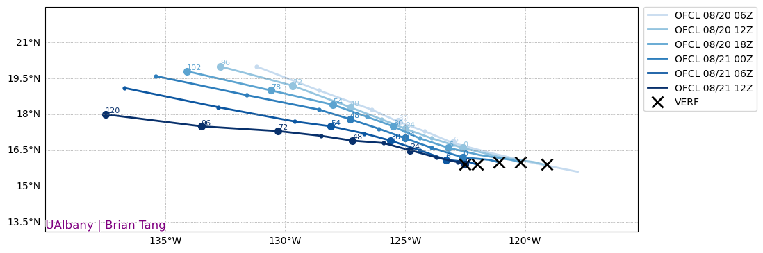
Hurricane Gilma Discussion Number 14 NWS National Hurricane Center Miami FL EP072024 200 PM PDT Wed Aug 21 2024
Gilma's satellite presentation has improved significantly over the past three hours as a clear eye has appeared in visible imagery, and the latest subjective Dvorak intensity estimates from TAFB and SAB were both T5.0/90-kt. Using these estimates Gilma's initial intensity is set to 90 kt for this advisory, which represents an increase of 30-kt over the past 24 hours, meeting the criteria of rapid intensification.
Gilma is moving more west-northwestward this afternoon, estimated at 285/6 kt. Over the next few days, a large subtropical ridge poleward of the hurricane should continue to steer it generally westward to west-northwestward. The latest track guidance has shifted slightly poleward, reversing the trend of the previous few cycles, possibly due to the more northern short-term motion as the hurricane's inner-core has become established. The latest NHC track was shifted slightly in that direction of the consensus track aids, blending them with the prior track forecast.
Given the improvements to the inner core, Gilma is expected to steadily strengthen over the next day. The NHC intensity forecast now shows strengthening to a Category 4 hurricane in 24 h, which is in agreement with the latest HCCA consensus aid and still slightly below some of the hurricane-regional models (e.g. HAFS-A and HAFS-B). After 48 h, sea-surface temperatures begin to gradually decrease, and slow weakening is still expected to begin at that time, though a little less than the previous advisory.
Visit the Caribbean-Central America Weather Thread where you can find at first post web cams,radars and observations from Caribbean basin members Click Here
Hurricane Gilma Discussion Number 15 NWS National Hurricane Center Miami FL EP072024 800 PM PDT Wed Aug 21 2024
Infrared and visible satellite imagery of Gilma this evening continues to depict a strong inner core with a well-defined eye. Deep convection with cold cloud tops near -80C have been persistent in the southern eye wall. Over the last hour or so the northern portion of the inner core has become a little more broken in infrared imagery, which suggests the rapid intensification has stopped. Subjective Dvorak satellite intensity estimates for this cycle remained unchanged from TAFB and SAB, both T5.0/90-kt. The objective intensity estimates from UW-CIMSS range from 90 to 100 kt. Using a blend of theses estimates, Gilma's initial intensity is set to 95 kt for this advisory.
Gilma is moving slowly west-northwestward with an estimated motion of 290/6 kt. A large subtropical ridge will continue to steer Gilma generally westward to west-northwestward during the next few days, with a gradual acceleration by the weekend. The latest NHC track is slightly to the right of the previous forecast, and lies between the previous forecast and the latest consensus aids.
Gilma is expected to continue to strengthen over the next day or so as the system moves over warm sea surface temperature with low vertical wind shear. The main change this cycle is that the peak and entire forecast period intensity guidance is much lower compared to 6 hours ago. The NHC peak intensity forecast is slightly lower than previous but still shows steady strengthening over the next 24h. However, the system should then begin to traverse cooler waters and a drier more stable airmass, with a faster weakening trend compared to the previous advisory. Note that the NHC intensity forecast is above most of the intensity guidance, primarily due to continuity constraints, and additional changes in the intensity forecast may be needed in subsequent forecasts if intensity aid trends continue.
Visit the Caribbean-Central America Weather Thread where you can find at first post web cams,radars and observations from Caribbean basin members Click Here
----- Current Analysis ----- Date : 22 AUG 2024 Time : 044020 UTC Lat : 16:28:47 N Lon : 123:48:00 W
CI# /Pressure/ Vmax 5.5 / 959.9mb/102.0kt
Final T# Adj T# Raw T# 5.5 5.7 5.7
Estimated radius of max. wind based on IR : 22 km
Center Temp : +10.9C Cloud Region Temp : -60.2C
Scene Type : EYE
0 likes
I am in no way a professional. Take what I say with a grain of salt as I could be totally wrong. Please refer to the NHC, NWS, or SPC for official information.
Hurricane Gilma Discussion Number 16 NWS National Hurricane Center Miami FL EP072024 200 AM PDT Thu Aug 22 2024
Gilma has continued to intensify while exhibiting a well-defined eye on geostationary satellite imagery, and convective cloud tops colder than -70 deg C are evident around the eyewall. The cloud pattern is fairly symmetric in appearance, and upper-level outflow is well defined over all quadrants of the circulation. The current intensity estimate is raised to 100 kt based on a subjective Dvorak classification from TAFB and various objective estimates from UW-CIMSS. This makes Gilma the first major hurricane of the 2024 east Pacific season.
Center fixes show a fairly slow forward speed toward the west-northwest, with an initial motion estimate of 290/5 kt. A mid-tropospheric trough near the California coast has broken down the subtropical ridge to the north of Gilma, resulting in a weaker than normal steering current. Over the next several days, the ridge is expected to build back rather slowly, resulting in only a gradual increase in the tropical cyclone's forward speed over the forecast period. The official track forecast is about the same as the one from the previous NHC advisory, and is near the southern side of the model suite.
Some additional strengthening is expected, since the system has a well-defined inner core and is in an environment of low shear while situated over warm waters. The short-term intensity forecast reflects current trends and is in line with much of the regional dynamical hurricane model guidance. In the next day or two, the SSTs below Gilma are expected to gradually decrease. Later in the forecast period, the cyclone will be moving into a drier and more stable air mass. These factors should cause slow weakening, and the official intensity forecast is similar to the previous one. Overall, the NHC intensity forecast is on the high end of the model guidance.
Visit the Caribbean-Central America Weather Thread where you can find at first post web cams,radars and observations from Caribbean basin members Click Here
This is eye candy for me. I even forget that she has a name when I stop to observe
1 likes
Sorry for the bad English sometimes...! For reliable and detailed information for any meteorological phenomenon, please consult the National Hurricane Center, Joint Typhoon Warning Center , or your local Meteo Center.
--------
Una cvm Christo, pro Christo, et in Christo. Sit nomen Domini benedictvm.
The NHC estimate is probably 5-10 kt too low, but I’m not sure its satellite presentation quite justified a Cat 4 yet. Still, this seems like it’ll once again be incredibly difficult for ADT to give a good intensity estimate with the fairly warm CDO.
I am only a meteorology enthusiast who knows a decent amount about tropical cyclones. Look to the professional mets, the NHC, or your local weather office for the best information.
Hurricane Gilma Discussion Number 17 NWS National Hurricane Center Miami FL EP072024 Issued by the NWS Weather Prediction Center College Park MD 500 AM HST Thu Aug 22 2024
Gilma has continued to intensify with recent tightening of the eyewall diameter in the last few hours. Concurrently, solid cooling was noted in the surrounding inner ring of convection. This has resulted in an increase in intensity for the Dvorak intensity estimates with TAFB up to a T6.0/6.0 or 115 knots while objective estimates from UW-CIMSS has seen a variation of Raw-T values between 5.5 and 5.8. As such, the intensity has been adjusted slightly upward to 110 knots and brings intensity up to a strong Category 3 hurricane on the Saffir-Simpson Scale.
A northwest trend in center fixes continues to show slow forward speed at 290/6 knots, though small wobbles have been noted as the eye has been tightening and stronger convergence nodes are noted along the inner eye wall supporting a weak asymmetry to the eye itself. Given weak mid-tropospheric forcing, storm motion will continue to be slow and is expected to turn more westward Friday into Saturday as it nears the 26-27C isotherm. Proximity to the thermal gradient and convective activity will play a role in the longer term forecast as well. Depending on the strength, a faster forward speed was noted through the guidance suite. As such, the official forecast is a bit faster along track though the track remains fairly stable.
Given that warmer oceans remain along the track of Gilma, some additional strengthening is expected with the low shear environment. As the cyclone reaches the 26-27C isotherm, gradual weakening is expected, but a slight northward adjustment will result in reduced warm, moist air to maintain its strength and slow weakening is expected after Friday morning. As the storm treads further west, cooler water is likely to increase weakening of the system through the weekend into early next week. As the system weakens and becomes shallower, forward speed will increase and perhaps further compound the weakening process a bit faster than prior forecast; however, the NHC intensity forecast remains on the higher end of the model guidance suite to better maintain continuity.
Visit the Caribbean-Central America Weather Thread where you can find at first post web cams,radars and observations from Caribbean basin members Click Here