2024 EPAC Season
Moderator: S2k Moderators
Forum rules

The posts in this forum are NOT official forecasts and should not be used as such. They are just the opinion of the poster and may or may not be backed by sound meteorological data. They are NOT endorsed by any professional institution or STORM2K. For official information, please refer to products from the National Hurricane Center and National Weather Service.
-
ElectricStorm

- Category 5

- Posts: 5139
- Age: 25
- Joined: Tue Aug 13, 2019 11:23 pm
- Location: Norman, OK
Re: 2024 EPAC Season
12z GFS has the 10/70 becoming a hurricane before nearing Hawaii as a weakening TS, much more bullish this run
0 likes
B.S Meteorology, University of Oklahoma '25
Please refer to the NHC, NWS, or SPC for official information.
Please refer to the NHC, NWS, or SPC for official information.
-
Kingarabian

- S2K Supporter

- Posts: 16345
- Joined: Sat Aug 08, 2009 3:06 am
- Location: Honolulu, Hawaii
Re: 2024 EPAC Season
Hawaii has something to watch:
Another area added.
2. Western Portion of the East Pacific:
Scattered showers and thunderstorms are associated with a broad
trough of low pressure located more than one thousand miles
west-southwest of the southern tip of the Baja California peninsula.
While this system may interact with another area of low pressure to
its west-southwest over the next several days, some gradual
development of this system is forecasted if it becomes the dominant
disturbance. A tropical depression is likely form during the middle
part of next week while the system moves westward to
west-northwestward over the western portion of the basin and into
the Central Pacific basin by the end of the week. Information on
this system's development can also be found in the Tropical Weather
Outlook for the Central Pacific basin.
* Formation chance through 48 hours...low...10 percent.
* Formation chance through 7 days...high...70 percent.
3. Well Southeast of the Hawaiian Islands:
A small area of low pressure located well southeast of the Hawaiian
Islands is associated with some disorganized showers and
thunderstorms. Some development of this system is possible this
weekend into early next week while it moves slowly over the western
portion of the East Pacific or Central Pacific basin. By the middle
of next week, this system could merge with a larger system
developing to its east. Information on this system's development can
also be found in the Tropical Weather Outlook for the Central
Pacific basin.
* Formation chance through 48 hours...low...20 percent.
* Formation chance through 7 days...low...20 percent
Another area added.
0 likes
RIP Kobe Bryant
-
Kingarabian
- S2K Supporter
- Posts: 16345
- Joined: Sat Aug 08, 2009 3:06 am
- Location: Honolulu, Hawaii
Re: 2024 EPAC Season
12z GFS now has 4 systems. Three stout systems and one getting absorbed. Will come down to spacing. But with the models showing the CPAC suddenly becoming favorable, it's believable.
0 likes
RIP Kobe Bryant
-
Kingarabian
- S2K Supporter
- Posts: 16345
- Joined: Sat Aug 08, 2009 3:06 am
- Location: Honolulu, Hawaii
Re: 2024 EPAC Season
For the eastern North Pacific...east of 140 degrees west longitude:
1. Well Offshore of Southwestern Mexico (EP99):
An area of low pressure located several hundred miles off the
southwestern coast of Mexico is producing showers and thunderstorms
that continue to show signs of organization. Recently-received
microwave satellite imagery also suggests the system is developing a
well-defined center, and if these trends continue, a tropical
depression is likely to form as soon as later today. The system is
forecast to move west-northwestward at about 10 to 15 mph across the
central portion of the eastern Pacific during the next several
days.
* Formation chance through 48 hours...high...90 percent.
* Formation chance through 7 days...high...90 percent.
2. Western Portion of the East Pacific:
Disorganized showers and thunderstorms are associated with a broad
trough of low pressure located well west-southwest of the southern
tip of the Baja California peninsula. This system is forecast to
interact with another disturbance to its west-southwest over the
next several days, which could limit additional development if this
system does not become the dominant disturbance. Regardless, a
tropical depression could still form during the middle part of the
week while the system moves westward to west-northwestward over the
western portion of the East Pacific basin before it possibly merges
with the disturbance currently located further west. Information on
this system's development can also be found in the Tropical Weather
Outlook for the Central Pacific basin.
* Formation chance through 48 hours...low...10 percent.
* Formation chance through 7 days...medium...50 percent.
3. Well Southeast of the Hawaiian Islands:
Another area of low pressure located well southeast of the Hawaiian
Islands is currently associated with some disorganized showers and
thunderstorms on its western side. This disturbance is forecast to
interact with the disturbance located to its east. If this system
becomes the dominant disturbance, some gradual development is
possible and a tropical depression could form by the middle part of
this week while it initially moves slowly over the western portion
of the East Pacific. A faster west-northwestward motion into the
Central Pacific basin is likely by the latter portion of the week.
Information on this system's development can also be found in the
Tropical Weather Outlook for the Central Pacific basin.
* Formation chance through 48 hours...low...30 percent.
* Formation chance through 7 days...medium...40 percent.
4. Eastern and Central Portion of the East Pacific:
Yet another area of low pressure could form well to the south of the
southwestern coast of Mexico over the next few days. Environmental
conditions appear generally conducive for some slow development of
this system thereafter as it moves slowly west-northwestward
throughout the week into the Central portion of the East Pacific
basin.
* Formation chance through 48 hours...low...near 0 percent.
* Formation chance through 7 days...low...20 percent.
0 likes
RIP Kobe Bryant
-
xtyphooncyclonex

- Category 5
- Posts: 3890
- Age: 24
- Joined: Sat Dec 08, 2012 9:07 am
- Location: Cebu City
- Contact:
Re: 2024 EPAC Season
Three concurrent hurricanes... very Niño-esque.

1 likes
REMINDER: My opinions that I, or any other NON Pro-Met in this forum, are unofficial. Please do not take my opinions as an official forecast and warning. I am NOT a meteorologist. Following my forecasts blindly may lead to false alarm, danger and risk if official forecasts from agencies are ignored.
-
MarioProtVI
- Category 5
- Posts: 1034
- Age: 24
- Joined: Sun Sep 29, 2019 7:33 pm
- Location: New Jersey
Re: 2024 EPAC Season
xtyphooncyclonex wrote:Three concurrent hurricanes... very Niño-esque.
https://i.ibb.co/sjVfsJN/gfs-mslp-pcpn-npac-18.png
It’s only the gfs that shows this. All the other models keep the trio or at least the other two weak. IIRC, the GFS seems to have some sort of Pacific bias wrt to the MJO.
1 likes
-
Yellow Evan

- Professional-Met

- Posts: 16231
- Age: 27
- Joined: Fri Jul 15, 2011 12:48 pm
- Location: Henderson, Nevada/Honolulu, HI
- Contact:
Re: 2024 EPAC Season
MarioProtVI wrote:xtyphooncyclonex wrote:Three concurrent hurricanes... very Niño-esque.
https://i.ibb.co/sjVfsJN/gfs-mslp-pcpn-npac-18.png
It’s only the gfs that shows this. All the other models keep the trio or at least the other two weak. IIRC, the GFS seems to have some sort of Pacific bias wrt to the MJO.
It's also the only model seemingly capable of showing anything strong in this basin - CMC rarely goes below 975 mbar in the deep tropics and the ECMWF has issues with emitting excessive outflow boundaries that reduces convection and its convective scheme is too CAPE dependent (which is why it's only aggressive in basins where TCG involves disturbances over land). The upper pattern is broadly favorable . Not saying the GFS will verify because it has its own share of issues with spinning up disturbances too aggressively within the monsoon trough in the medium range but this isn't exactly a medium range scenario at this point either so its output can probably be taken a bit more seriously.
3 likes
-
xtyphooncyclonex
- Category 5
- Posts: 3890
- Age: 24
- Joined: Sat Dec 08, 2012 9:07 am
- Location: Cebu City
- Contact:
Re: 2024 EPAC Season
Not that the GFS scenario is a certainty. But with favorable conditions and Gilma about to explode and linger, we could be in for the much-awaited ACE boost with a pretty big outbreak. We could approach 50-60 units in a week, around at least 15-25 from Gilma alone. GFS runs have lately been trending closer, faster and stronger as well.
Gilma also seems to have outperformed forecasts so far pretty substantially. Interesting to see if the others follow suit or just bust.
Gilma also seems to have outperformed forecasts so far pretty substantially. Interesting to see if the others follow suit or just bust.
0 likes
REMINDER: My opinions that I, or any other NON Pro-Met in this forum, are unofficial. Please do not take my opinions as an official forecast and warning. I am NOT a meteorologist. Following my forecasts blindly may lead to false alarm, danger and risk if official forecasts from agencies are ignored.
-
cycloneye

- Admin

- Posts: 149261
- Age: 69
- Joined: Thu Oct 10, 2002 10:54 am
- Location: San Juan, Puerto Rico
Re: 2024 EPAC Season
This will be invest 92E shortly.
Eastern and Central Portion of the East Pacific:
Disorganized showers and thunderstorms continue in association with
a trough of low pressure centered several hundred miles southwest of
the coast of southwestern Mexico. Environmental conditions are
forecast to be generally conducive for development over the next
several days, and a tropical depression is likely to form in the
next two to three days while the system moves west-northwestward
into the central portion of the East Pacific, well offshore of
Mexico.
* Formation chance through 48 hours...medium...40 percent.
* Formation chance through 7 days...high...80 percent.
0 likes
Visit the Caribbean-Central America Weather Thread where you can find at first post web cams,radars
and observations from Caribbean basin members Click Here
and observations from Caribbean basin members Click Here


Re: 2024 EPAC Season
Could be 3 spinning TCs simultaneously early next week. You'd think the EPAC would be active early season and shut down after, turning to be opposite so far.
0 likes
The above post and any post by Ntxw is NOT an official forecast and should not be used as such. It is just the opinion of the poster and may or may not be backed by sound meteorological data. It is NOT endorsed by any professional institution including Storm2k. For official information, please refer to NWS products.
Help support Storm2K!
-
Kingarabian
- S2K Supporter
- Posts: 16345
- Joined: Sat Aug 08, 2009 3:06 am
- Location: Honolulu, Hawaii
Re: 2024 EPAC Season
Ntxw wrote:Could be 3 spinning TCs simultaneously early next week. You'd think the EPAC would be active early season and shut down after, turning to be opposite so far.
ENSO was streamrolling into what appeared to be a moderate La Nina. Probably played a role in the super slow start. Now with ENSO backing off it looks like the EPAC could push out some decent systems.
0 likes
RIP Kobe Bryant
-
Yellow Evan
- Professional-Met
- Posts: 16231
- Age: 27
- Joined: Fri Jul 15, 2011 12:48 pm
- Location: Henderson, Nevada/Honolulu, HI
- Contact:
Re: 2024 EPAC Season
Ntxw wrote:Could be 3 spinning TCs simultaneously early next week. You'd think the EPAC would be active early season and shut down after, turning to be opposite so far.
I'll tweet about it later but we have a solid +PMM that's opening the western EPAC and CPAC up for business through weaker trades and upper easterlies. La Nina configuration has been pretty east based so far.
0 likes
-
Yellow Evan
- Professional-Met
- Posts: 16231
- Age: 27
- Joined: Fri Jul 15, 2011 12:48 pm
- Location: Henderson, Nevada/Honolulu, HI
- Contact:

-
Kingarabian
- S2K Supporter
- Posts: 16345
- Joined: Sat Aug 08, 2009 3:06 am
- Location: Honolulu, Hawaii
Re: 2024 EPAC Season
Yellow Evan wrote:Ntxw wrote:Could be 3 spinning TCs simultaneously early next week. You'd think the EPAC would be active early season and shut down after, turning to be opposite so far.
I'll tweet about it later but we have a solid +PMM that's opening the western EPAC and CPAC up for business through weaker trades and upper easterlies. La Nina configuration has been pretty east based so far.
Waters west of NWAmerica have warmed compared to the start of the season which also helps.
1 likes
RIP Kobe Bryant
-
Yellow Evan
- Professional-Met
- Posts: 16231
- Age: 27
- Joined: Fri Jul 15, 2011 12:48 pm
- Location: Henderson, Nevada/Honolulu, HI
- Contact:

-
gatorcane

- S2K Supporter
- Posts: 23708
- Age: 48
- Joined: Sun Mar 13, 2005 3:54 pm
- Location: Boca Raton, FL
Re: 2024 EPAC Season
Looks like we are in an El Nino with so much activity in the EPAC and nothing in the Atlantic.
0 likes

Re: 2024 EPAC Season
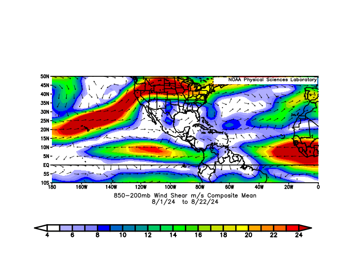
gatorcane wrote:Looks like we are in an El Nino with so much activity in the EPAC and nothing in the Atlantic.
Shear in August is clearly in line with a La Nina, with strong shear in EPAC and low shear in the Caribbean. In fact, I think the EPAC shear was stronger than some clear-cut Nina years, and Caribbean shear one of the lowest.
0 likes
TC naming lists: retirements and intensity
Most aggressive Advisory #1's in North Atlantic (cr. kevin for starting the list)
Most aggressive Advisory #1's in North Atlantic (cr. kevin for starting the list)
-
WaveBreaking

- Category 2

- Posts: 717
- Joined: Sun Jun 30, 2024 11:33 am
- Location: US
Re: 2024 EPAC Season
Teban54 wrote:gatorcane wrote:Looks like we are in an El Nino with so much activity in the EPAC and nothing in the Atlantic.
Shear in August is clearly in line with a La Nina, with strong shear in EPAC and low shear in the Caribbean. In fact, I think the EPAC shear was stronger than some clear-cut Nina years, and Caribbean shear one of the lowest.
https://i.postimg.cc/2yXFD52Q/compday-8w-UOaib-Mw9.gif
Somewhat unrelated but look how strong that easterly jet near Africa is.
0 likes
I am NOT a professional meteorologist, so take all of my posts with a grain of salt. My opinions are mine and mine alone.
Re: 2024 EPAC Season
WaveBreaking wrote:Teban54 wrote:gatorcane wrote:Looks like we are in an El Nino with so much activity in the EPAC and nothing in the Atlantic.
Shear in August is clearly in line with a La Nina, with strong shear in EPAC and low shear in the Caribbean. In fact, I think the EPAC shear was stronger than some clear-cut Nina years, and Caribbean shear one of the lowest.
https://i.postimg.cc/2yXFD52Q/compday-8w-UOaib-Mw9.gif
Somewhat unrelated but look how strong that easterly jet near Africa is.
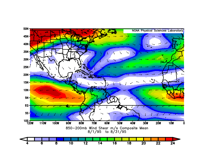
As I mentioned in this analysis, the AEJ is the strongest by far since 1995. But years with AEJ shear close to the current level also have an inconsistent record of eventual Atlantic seasonal activity, ranging from 2013 to hyperactive (1999).
2 likes
TC naming lists: retirements and intensity
Most aggressive Advisory #1's in North Atlantic (cr. kevin for starting the list)
Most aggressive Advisory #1's in North Atlantic (cr. kevin for starting the list)

Re: 2024 EPAC Season
Even with Gilma, the EPac still hasn’t approached the Atlantic’s ACE yet (42 vs 55). Even assuming Gilma has been under-estimated at various points and its actual ACE was likely higher as a result, it still hasn’t been enough to match the Atlantic; at most it probably would’ve added a few more units.
0 likes
Irene '11 Sandy '12 Hermine '16 5/15/2018 Derecho Fay '20 Isaias '20 Elsa '21 Henri '21 Ida '21
I am only a meteorology enthusiast who knows a decent amount about tropical cyclones. Look to the professional mets, the NHC, or your local weather office for the best information.
I am only a meteorology enthusiast who knows a decent amount about tropical cyclones. Look to the professional mets, the NHC, or your local weather office for the best information.
Who is online
Users browsing this forum: mixedDanilo.E and 85 guests