
EP, 92, 2024082206, , BEST, 0, 145N, 1111W, 25, 1010, DB, 34, NEQ, 0, 0, 0, 0, 1011, 150, 60, 0, 0, E, 0, , 0, 0, INVEST, S, 0, , 0, 0, 0, 0, genesis-num, 022, SPAWNINVEST, ep742024 to ep922024,
EPAC: HECTOR - Post-Tropical - Discussion
Moderator: S2k Moderators
-
Yellow Evan

- Professional-Met

- Posts: 16257
- Age: 27
- Joined: Fri Jul 15, 2011 12:48 pm
- Location: Henderson, Nevada/Honolulu, HI
- Contact:

-
DorkyMcDorkface

- Category 5

- Posts: 1042
- Age: 28
- Joined: Mon Sep 30, 2019 1:32 pm
- Location: Mid-Atlantic
Re: EPAC: INVEST 92E - Discussion

0 likes
Please note the thoughts expressed by this account are solely those of the user and are from a hobbyist perspective. For more comprehensive analysis, consult an actual professional meteorologist or meteorological agency.
Floyd 1999 | Isabel 2003 | Hanna 2008 | Irene 2011 | Sandy 2012 | Isaias 2020
-
Yellow Evan
- Professional-Met
- Posts: 16257
- Age: 27
- Joined: Fri Jul 15, 2011 12:48 pm
- Location: Henderson, Nevada/Honolulu, HI
- Contact:
Re: EPAC: INVEST 92E - Discussion
Probably classifiable.
However, with delayed TCG, time to reach peak intensity has been cut.
However, with delayed TCG, time to reach peak intensity has been cut.
0 likes
-
Kingarabian

- S2K Supporter

- Posts: 16378
- Joined: Sat Aug 08, 2009 3:06 am
- Location: Honolulu, Hawaii
Re: EPAC: INVEST 92E - Discussion
Tropical Weather Outlook
NWS National Hurricane Center Miami FL
500 PM PDT Sat Aug 24 2024
For the eastern North Pacific...east of 140 degrees west longitude:
Active Systems:
The National Hurricane Center is issuing advisories on Hurricane
Gilma, located about midway between the southern tip of the Baja
California peninsula and the Hawaiian Islands.
1. Central and Western Portion of the East Pacific (EP92):
Shower and thunderstorm activity remains displaced to the southwest
of an area of low pressure located well to the southwest of the
southern tip of the Baja California peninsula. Environmental winds
are forecast to become more conducive for development of the low
during the next day or two, and a tropical depression is expected to
form this weekend or early next week while moving toward the west or
west-northwest at around 10 mph.
* Formation chance through 48 hours...high...80 percent.
* Formation chance through 7 days...high...90 percent.
Forecaster Berg
So.. no classification if convection is displaced from the LLC. But then how were Bud and Daniel classified despite being heavily sheared systems, start to finish?
0 likes
RIP Kobe Bryant
-
cycloneye

- Admin

- Posts: 149706
- Age: 69
- Joined: Thu Oct 10, 2002 10:54 am
- Location: San Juan, Puerto Rico
Re: EPAC: HECTOR - Tropical Storm - Discussion
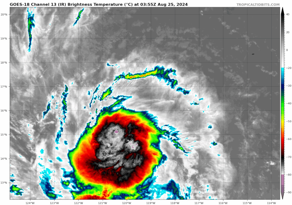
Tropical Storm Hector Discussion Number 1
NWS National Hurricane Center Miami FL EP082024
1100 AM HST Sun Aug 25 2024
Two ASCAT overpasses recently sampled the tropical disturbance well
to the southwest of Cabo San Lucas, Mexico. These scatterometer
observations revealed that the system now has a well-defined
surface circulation with maximum winds of around 40 kt. Although
some higher wind speeds were noted, these vectors are believed to
be rain-contaminated and a little inflated. Based on these data,
the system is being upgraded to Tropical Storm Hector. The
low-level center is situated near the northern edge of a rather
ragged-looking area of deep convection, and banding features are
not well-defined at this time.
The earlier center fixes from conventional satellite imagery had
considerable spread, making the initial motion a rather uncertain
270/10 kt. A mid-level ridge should be maintained to the north of
Hector for the next several days. Therefore, a west-northwestward
or westward track is forecast during the upcoming 5-day period.
The NHC track forecast is close to the simple model consensus.
Over the next couple of days, Hector should be moving through an
environment that is marginally conducive for strengthening. The
tropical cyclone is likely to pass near or over the wake of
Hurricane Gilma, which could limit strengthening. The official
intensity forecast is similar to the latest Decay-SHIPS prediction,
and shows only modest strengthening over the next few days followed
by gradual weakening. It should be noted that some of the global
models, such as the ECMWF, suggest that Hector could weaken faster
than shown here during the latter part of the forecast period.
FORECAST POSITIONS AND MAX WINDS
INIT 25/2100Z 15.9N 122.5W 40 KT 45 MPH
12H 26/0600Z 16.2N 123.9W 45 KT 50 MPH
24H 26/1800Z 16.5N 126.0W 50 KT 60 MPH
36H 27/0600Z 16.9N 128.0W 50 KT 60 MPH
48H 27/1800Z 17.3N 130.0W 50 KT 60 MPH
60H 28/0600Z 17.7N 132.2W 55 KT 65 MPH
72H 28/1800Z 18.0N 134.5W 50 KT 60 MPH
96H 29/1800Z 18.0N 139.0W 45 KT 50 MPH
120H 30/1800Z 18.0N 144.0W 35 KT 40 MPH
$$
Forecaster Pasch
0 likes
Visit the Caribbean-Central America Weather Thread where you can find at first post web cams,radars
and observations from Caribbean basin members Click Here
and observations from Caribbean basin members Click Here
-
cycloneye
- Admin
- Posts: 149706
- Age: 69
- Joined: Thu Oct 10, 2002 10:54 am
- Location: San Juan, Puerto Rico
Re: EPAC: HECTOR - Tropical Storm - Discussion
Tropical Storm Hector Discussion Number 2
NWS National Hurricane Center Miami FL EP082024
500 PM HST Sun Aug 25 2024
Hector remains a sheared tropical storm this evening. Recent
microwave imagery from AMSR2 and GMI showed the low-level
circulation on the northern edge of the deep convection, with a rain
band extending to the south. Dvorak estimates from TAFB and SAB
were T3.0/45-kt and T2.5/35-kt, respectively. The initial
intensity remains at 40 kt, representing a blend of these estimates.
The storm is moving along the southern side of mid-level ridge at an
estimated 275/10 kt. The ridge should be the dominant steering
feature for the majority of the forecast period, and Hector should
generally move westward to west-northwestward through the end of
the week. There is a bit of along-track spread in the model
guidance, with the European model suggesting a faster forward
motion compare to the American global and regional models. The
latest track forecast is slightly slower than the previous
prediction and close to the corrected consensus aid, HCCA.
Environmental conditions should allow for gradual strengthening over
the next couple of days. The deep-layer vertical wind shear is
expected to be light-to-moderate with sufficiently warm sea surface
temperatures along the forecast track. By mid-week, most global
models show drier mid-level air wrapping around the circulation and
increasing vertical wind shear. These conditions, and possibly the
cold wake of Hurricane Gilma, should lead to steady weakening and
most guidance shows Hector losing its deep convection by the end of
forecast period. The NHC intensity prediction is similar to
earlier advisory, but now shows Hector as a remnant low by day 5.
The forecast lies near the high end of the model guidance envelope,
closest to the regional model HWRF.
FORECAST POSITIONS AND MAX WINDS
INIT 26/0300Z 16.2N 123.2W 40 KT 45 MPH
12H 26/1200Z 16.5N 124.8W 45 KT 50 MPH
24H 27/0000Z 16.9N 126.8W 50 KT 60 MPH
36H 27/1200Z 17.3N 128.8W 50 KT 60 MPH
48H 28/0000Z 17.6N 130.9W 55 KT 65 MPH
60H 28/1200Z 18.0N 133.0W 55 KT 65 MPH
72H 29/0000Z 18.0N 135.3W 50 KT 60 MPH
96H 30/0000Z 18.1N 140.0W 40 KT 45 MPH
120H 31/0000Z 17.6N 145.0W 30 KT 35 MPH...POST-TROP/REMNT LOW
$$
Forecaster Bucci
0 likes
Visit the Caribbean-Central America Weather Thread where you can find at first post web cams,radars
and observations from Caribbean basin members Click Here
and observations from Caribbean basin members Click Here
-
Category5Kaiju

- Category 5
- Posts: 4345
- Joined: Thu Dec 24, 2020 12:45 pm
- Location: Seattle during the summer, Phoenix during the winter
Re: EPAC: HECTOR - Tropical Storm - Discussion
A far cry from the 2018 version 
2 likes
Unless explicitly stated, all information in my posts is based on my own opinions and observations. Tropical storms and hurricanes can be extremely dangerous. Refer to an accredited weather research agency or meteorologist if you need to make serious decisions regarding an approaching storm.
-
dexterlabio
- Category 5
- Posts: 3517
- Joined: Sat Oct 24, 2009 11:50 pm
Re: EPAC: HECTOR - Tropical Storm - Discussion
^in that case you can also say Gilma is far cry from its 2018 version
0 likes
Personal Forecast Disclaimer:
The posts in this forum are NOT official forecast and should not be used as such. They are just the opinion of the poster and may or may not be backed by sound meteorological data. They are NOT endorsed by any professional institution or storm2k.org. For official information, please refer to the NHC and NWS products.
The posts in this forum are NOT official forecast and should not be used as such. They are just the opinion of the poster and may or may not be backed by sound meteorological data. They are NOT endorsed by any professional institution or storm2k.org. For official information, please refer to the NHC and NWS products.
-
cycloneye
- Admin
- Posts: 149706
- Age: 69
- Joined: Thu Oct 10, 2002 10:54 am
- Location: San Juan, Puerto Rico
Re: EPAC: HECTOR - Tropical Storm - Discussion
Tropical Storm Hector Discussion Number 3
NWS National Hurricane Center Miami FL EP082024
1100 PM HST Sun Aug 25 2024
Hector has generally changed little during the past several hours.
The storm remains sheared with the low-level center located near the
northern edge of the main area of deep convection as seen in
microwave images. The latest objective and subjective Dvorak
estimates range from 35 to 45 kt, and a recent ASCAT-C pass showed a
swath of 35-40 kt winds to the east of the center. Based on all of
this information, the initial intensity is again held at 40 kt.
The storm is moving westward (280 degrees) at 8 kt, and a continued
relatively slow westward to west-northwestward motion should persist
for another day or two. Thereafter, a slightly faster westward
motion is forecast as a low- to mid-level ridge builds to the north
of the system. There is some along-track spread in the guidance,
but most of the models show a similar theme. Little change was made
to the previous NHC track, and this one lies fairly close to the
various consensus models.
Hector is currently experiencing some northerly wind shear. The
shear should decrease a little during the next couple of days, which
could allow Hector to gain some strength. However, the
strengthening will likely be tempered due to Hector passing over
Gilma's cool wake. As Hector nears the central Pacific basin in a
few days, the models show the storm moving into a region of stronger
shear and drier air, which should end the opportunity for
strengthening and induce weakening. The NHC forecast shows Hector
becoming a remnant low by day 5, but most of the global models
depict this transition occurring sooner than that. The intensity
forecast is nudged downward from the previous one, but still lies at
the high end of the latest model guidance.
FORECAST POSITIONS AND MAX WINDS
INIT 26/0900Z 16.3N 123.9W 40 KT 45 MPH
12H 26/1800Z 16.6N 125.3W 45 KT 50 MPH
24H 27/0600Z 17.0N 127.3W 50 KT 60 MPH
36H 27/1800Z 17.4N 129.2W 50 KT 60 MPH
48H 28/0600Z 17.7N 131.4W 50 KT 60 MPH
60H 28/1800Z 17.8N 133.4W 45 KT 50 MPH
72H 29/0600Z 17.9N 135.9W 40 KT 45 MPH
96H 30/0600Z 17.6N 140.8W 35 KT 40 MPH
120H 31/0600Z 17.0N 146.6W 30 KT 35 MPH...POST-TROP/REMNT LOW
$$
Forecaster Cangialosi
0 likes
Visit the Caribbean-Central America Weather Thread where you can find at first post web cams,radars
and observations from Caribbean basin members Click Here
and observations from Caribbean basin members Click Here
-
cycloneye
- Admin
- Posts: 149706
- Age: 69
- Joined: Thu Oct 10, 2002 10:54 am
- Location: San Juan, Puerto Rico
Re: EPAC: HECTOR - Tropical Storm - Discussion
Tropical Storm Hector Discussion Number 4
NWS National Hurricane Center Miami FL EP082024
500 AM HST Mon Aug 26 2024
Microwave imagery continues to show evidence of northerly shear
over the cyclone, with the mid-level center displaced a little to
the south of the surface center. However, the overall cloud
pattern appears to be slightly better organized than it was
yesterday with some evidence of banding features over the eastern
portion of the circulation. The advisory intensity has been
increased a bit, to 45 kt, in agreement with subjective Dvorak
Current Intensity Numbers from TAFB and SAB.
Center fixes from geostationary and microwave imagery give a
westward motion at around 270/9 kt. A weak low- to mid-level ridge
is currently situated to the north of Hector, and the global
models suggest that the ridge will build a little in a few days.
The track guidance calls for a west-northwestward to westward
heading with a slight increase in forward speed for the next 3-5
days. The official forecast is similar to the previous one and
follows the dynamical model consensus predictions.
Although the vertical shear is not forecast to be very strong,
Hector is expected to traverse marginal SSTs for the next few days
while it moves over or near the oceanic wake of Hurricane Gilma.
Also, the global models show the system encountering increasingly
dry air at low- to mid-levels. The intensity guidance does not
call for much additional strengthening and the official
forecast is at the high end of the model predictions. With the
expected less favorable environment, a weakening trend is likely to
begin in a couple of days. Simulated satellite imagery from the
ECMWF and GFS models show little or no deep convection associated
with Hector by the end of the forecast period, so the official
forecast calls for the system to become a remnant low at that time.
FORECAST POSITIONS AND MAX WINDS
INIT 26/1500Z 16.2N 124.9W 45 KT 50 MPH
12H 27/0000Z 16.6N 126.3W 45 KT 50 MPH
24H 27/1200Z 17.1N 128.2W 50 KT 60 MPH
36H 28/0000Z 17.4N 130.2W 50 KT 60 MPH
48H 28/1200Z 17.6N 132.4W 45 KT 50 MPH
60H 29/0000Z 17.7N 134.7W 40 KT 45 MPH
72H 29/1200Z 17.7N 137.2W 40 KT 45 MPH
96H 30/1200Z 17.5N 142.4W 35 KT 40 MPH
120H 31/1200Z 17.5N 148.0W 30 KT 35 MPH...POST-TROP/REMNT LOW
$$
Forecaster Pasch
0 likes
Visit the Caribbean-Central America Weather Thread where you can find at first post web cams,radars
and observations from Caribbean basin members Click Here
and observations from Caribbean basin members Click Here
-
Kingarabian
- S2K Supporter
- Posts: 16378
- Joined: Sat Aug 08, 2009 3:06 am
- Location: Honolulu, Hawaii
Re: EPAC: HECTOR - Tropical Storm - Discussion
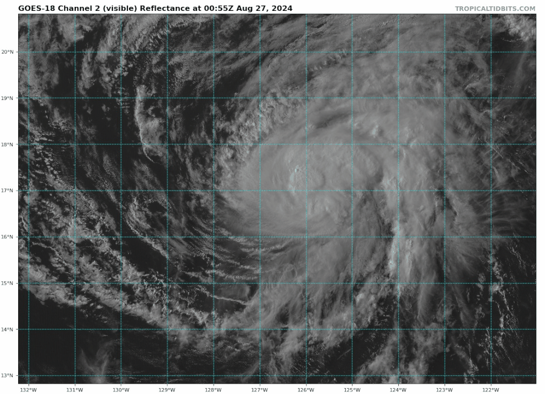
Still tilted but it's appearance has improved drastically.
0 likes
RIP Kobe Bryant
-
cycloneye
- Admin
- Posts: 149706
- Age: 69
- Joined: Thu Oct 10, 2002 10:54 am
- Location: San Juan, Puerto Rico
Re: EPAC: HECTOR - Tropical Storm - Discussion
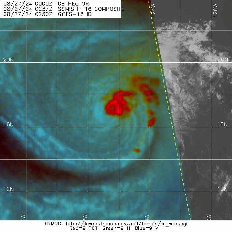
Tropical Storm Hector Discussion Number 6
NWS National Hurricane Center Miami FL EP082024
500 PM HST Mon Aug 26 2024
Hector appears to be holding steady. Deep convection has rotated to
the northeast of the surface circulation and there is outflow
present in the eastern half of the storm. An SSMIS microwave pass
from 0024 UTC suggests that while the storm may be less tilted, the
area of deep convection has decreased. The initial intensity is
held at 45 kt based on an earlier ASCAT pass. The wind radii have
also been adjusted outward based on the scatterometer data.
The cyclone is moving westward at 10 kt along the southern side of a
low- to mid-level ridge. This general westward to
west-northwestward motion, with a slight increase in forward speed,
should continue through the entire forecast period. The latest
forecast is essentially unchanged from the previous prediction.
Model guidance is showing that the window for potential
intensification should be ending in a day or so. Weak-to-moderate
shear and sufficiently warm ocean waters could allow Hector to
strengthen a little more within a day, but by Thursday, all guidance
suggests that deteriorating environmental conditions should induce
gradual weakening. This weakening could also be hastened by
Hector's passage over Hurricane Gilma's cold wake. The official
forecast is still on the high end of the guidance envelope and very
similar to the earlier intensity forecast, but now shows Hector as a
remnant low by day 4.
FORECAST POSITIONS AND MAX WINDS
INIT 27/0300Z 16.8N 126.7W 45 KT 50 MPH
12H 27/1200Z 17.2N 128.2W 50 KT 60 MPH
24H 28/0000Z 17.5N 130.3W 50 KT 60 MPH
36H 28/1200Z 17.8N 132.4W 45 KT 50 MPH
48H 29/0000Z 17.8N 134.7W 40 KT 45 MPH
60H 29/1200Z 17.9N 137.1W 40 KT 45 MPH
72H 30/0000Z 17.8N 139.7W 35 KT 40 MPH
96H 31/0000Z 17.6N 145.4W 30 KT 35 MPH...POST-TROP/REMNT LOW
120H 01/0000Z 18.0N 151.0W 25 KT 30 MPH...POST-TROP/REMNT LOW
$$
Forecaster Bucci
0 likes
Visit the Caribbean-Central America Weather Thread where you can find at first post web cams,radars
and observations from Caribbean basin members Click Here
and observations from Caribbean basin members Click Here
Who is online
Users browsing this forum: No registered users and 85 guests