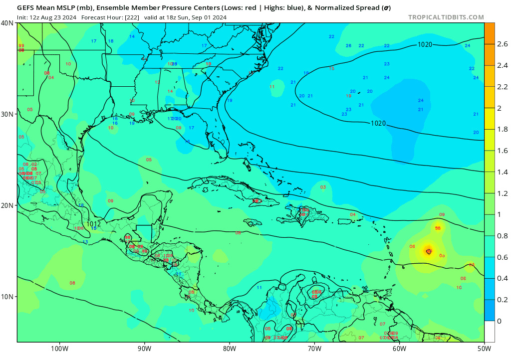
GFS still has vorticity moving W in the Gulf late next week, but shear remains hostile until it is almost on the S TX coast. A few of its ensembles show low, but above 1010mb. There probably won't be action in the Gulf this upcoming wee
But GFS ensembles look exciting starting before 10 days, which, if it continues (systems are a day further W on the models for each day that passes), maybe we may see the dimmer switch turned up for September.
2024 Global Model Runs Discussion (Out thru day 16)
Moderator: S2k Moderators
Forum rules

The posts in this forum are NOT official forecasts and should not be used as such. They are just the opinion of the poster and may or may not be backed by sound meteorological data. They are NOT endorsed by any professional institution or STORM2K. For official information, please refer to products from the National Hurricane Center and National Weather Service.

Re: 2024 Global Model Runs Discussion (Out thru day 16)
TomballEd wrote:GFS still has vorticity movu=ing W in the Gulf late next week, but shear remains hostile until it is almost on the STX coast. A few of its ensembles show low, but above 1010mb. There probably won't be action in the Gulf this upcoming wee
But GFS ensembles look exciting starting before 10 days, which, if it continues (systems are a day further W on the models for each day that passes), maybe we may see the dimmer switch turned up for September.
It looks like the opposite shear timing with this Gulf thing. I see shear bouncing between 5-20kt for the first three days it's in the Gulf. This would normally be enough for tropical storm formation, but it appears to struggle with moisture on all runs. It is good enough for steady development of a mid level circulation, which slowly drills down before the upper-level wind vector tilts & blasts the developing circulation with 30kt of shear. I agree formation is unlikely but it's peak season... so bears watching!
1 likes
Kendall -> SLO -> PBC
Memorable Storms: Katrina (for its Florida landfall...) Wilma Matthew Irma
Memorable Storms: Katrina (for its Florida landfall...) Wilma Matthew Irma
-
Stratton23
- Category 5

- Posts: 3518
- Joined: Fri Jul 21, 2023 10:59 pm
- Location: Katy, Tx
Re: 2024 Global Model Runs Discussion (Out thru day 16)
Ubuntwo models might be under doing the moisture with that wave, it currently is pretty convectively active, not sure models are quite seeing that at the moment
1 likes
-
TomballEd
- Category 5
- Posts: 1263
- Age: 62
- Joined: Wed Aug 16, 2023 4:52 pm
- Location: Spring/Klein area, not Tomball
Re: 2024 Global Model Runs Discussion (Out thru day 16)
I mention GEFS get interesting by day 10 and at two weeks look very, very interesting?
I can't Giphy at work. Its blocked.
I can't Giphy at work. Its blocked.
0 likes
-
SFLcane

- S2K Supporter

- Posts: 10281
- Age: 48
- Joined: Sat Jun 05, 2010 1:44 pm
- Location: Lake Worth Florida
Re: 2024 Global Model Runs Discussion (Out thru day 16)
TomballEd wrote:I mention GEFS get interesting by day 10 and at two weeks look very, very interesting?
I can't Giphy at work. Its blocked.
2 likes
-
Hurrilurker

- Category 2

- Posts: 738
- Joined: Mon Jun 09, 2003 3:32 pm
- Location: San Francisco, CA
Re: 2024 Global Model Runs Discussion (Out thru day 16)
SFLcane wrote:TomballEd wrote:I mention GEFS get interesting by day 10 and at two weeks look very, very interesting?
I can't Giphy at work. Its blocked.
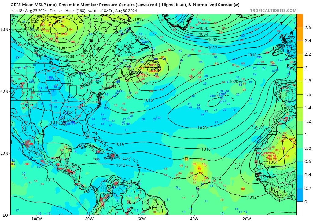
https://i.postimg.cc/MZmPMJDX/GHGHG.gif
Starting to look interesting, but if there was a stronger Bermuda high pressure at the same time it would look much, much worse. Most of the activity is OTS. The question is when/if that pattern will set up in the next 6-8 weeks.
0 likes

Re: 2024 Global Model Runs Discussion (Out thru day 16)
Euro's usual pre-switch antics: it's developing tropical storms over Africa, and then flinging them northwest over Morocco/Western Sahara (something else I've observed in many prior mid to late August runs, days before storms actually start showing up on the models)


Seeing this from the Euro is a good indicator it seems, that it's starting to see the monsoon trough breakdown but seems to, for some reason, strengthens them too quickly and moves them north too soon, while they're still over land
Seeing this from the Euro is a good indicator it seems, that it's starting to see the monsoon trough breakdown but seems to, for some reason, strengthens them too quickly and moves them north too soon, while they're still over land
7 likes
The above post is not official and should not be used as such. It is the opinion of the poster and may or may not be backed by sound meteorological data. It is not endorsed by any professional institution or storm2k.org. For official information, please refer to the NHC and NWS products.
-
gatorcane

- S2K Supporter
- Posts: 23708
- Age: 48
- Joined: Sun Mar 13, 2005 3:54 pm
- Location: Boca Raton, FL
Re: 2024 Global Model Runs Discussion (Out thru day 16)
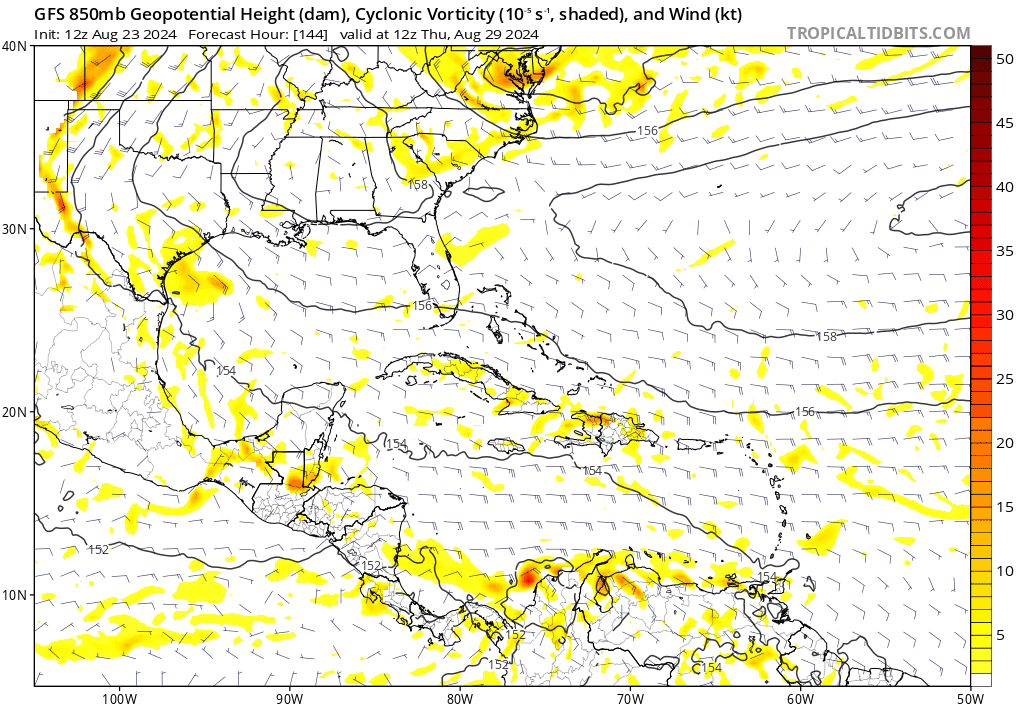
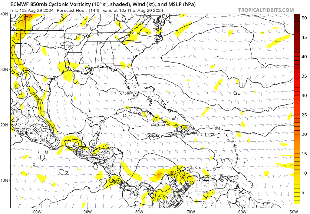
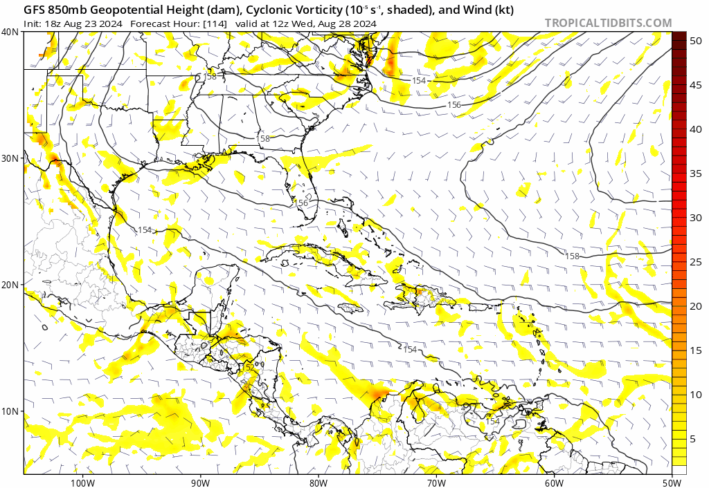
Both the GFS and Euro are showing a tropical wave moving through the Bahamas with some development near Florida in the long-range. We can track the wave on both models using the 850MB vorticity from 144 to 240 hours. Both models are in remarkable agreement on the location of this wave at 240 hours. The GFS actually does develop it even further off the SE US coast beyond 240 hours but we don't get the Euro output beyond 240 to know what it does with it. They don't show significant development (yet) but we are far out still:
0 likes
-
Stratton23
- Category 5
- Posts: 3518
- Joined: Fri Jul 21, 2023 10:59 pm
- Location: Katy, Tx
Re: 2024 Global Model Runs Discussion (Out thru day 16)
The 18z ICON tries to develop a last second circulation with the upper low currently in the gulf as it approaches the texas coast line, it also has the 2nd gulf wave/ disturbance, and it has an interesting little tight vort signature in the caribbean
0 likes
-
cycloneye

- Admin

- Posts: 149267
- Age: 69
- Joined: Thu Oct 10, 2002 10:54 am
- Location: San Juan, Puerto Rico
Re: 2024 Global Model Runs Discussion (Out thru day 16)
https://x.com/dmorris9661/status/1827093519644651995
https://x.com/dmorris9661/status/1827093522639691923
https://x.com/dmorris9661/status/1827093522639691923
1 likes
Visit the Caribbean-Central America Weather Thread where you can find at first post web cams,radars
and observations from Caribbean basin members Click Here
and observations from Caribbean basin members Click Here
-
Stratton23
- Category 5
- Posts: 3518
- Joined: Fri Jul 21, 2023 10:59 pm
- Location: Katy, Tx
Re: 2024 Global Model Runs Discussion (Out thru day 16)
The ICON nearly develops a weak closed low with the 2nd wave, little piece of energy moves west in the caribbean, holding together somewhat, im going bold here and saying we have a named storm before august ends despite what models show, i have a feeling we could have a sneaky system try to develop closer to home and just barely get organized enough to be called francine, maybe from that gulf disturbance
0 likes

-
MEANINGLESS_NUMBERS
- Category 2
- Posts: 503
- Joined: Mon Nov 02, 2020 1:43 pm
Re: 2024 Global Model Runs Discussion (Out thru day 16)
SFLcane wrote:TomballEd wrote:I mention GEFS get interesting by day 10 and at two weeks look very, very interesting?
I can't Giphy at work. Its blocked.
https://i.postimg.cc/MZmPMJDX/GHGHG.gif
What is that BEAST crushing Bermuda on September 8th? Is there a way to view individual ensemble members?
0 likes
Emily '87, Felix '95, Gert '99, Fabian '03, Humberto '19, Paulette '20, Teddy '20, Fiona '22, Lee '23, Ernesto '24, Humberto/Imelda '25
-
Stratton23
- Category 5
- Posts: 3518
- Joined: Fri Jul 21, 2023 10:59 pm
- Location: Katy, Tx
Re: 2024 Global Model Runs Discussion (Out thru day 16)
Maybe something to watch as its in the 7-9 day range, the 18z GFS has something trying to spin just to the south of florida, maybe its the same wave that the euro has at the end of its run near the bamahas?
0 likes
-
Blown Away

- S2K Supporter
- Posts: 10253
- Joined: Wed May 26, 2004 6:17 am
Re: 2024 Global Model Runs Discussion (Out thru day 16)
GFS continues showing a very strong TW moving over GA and into FL/Bahamas in the mid range… This area needs to be watched IMO, easily could be a named system IMO…
0 likes
Hurricane Eye Experience: David 79, Irene 99, Frances 04, Jeanne 04, Wilma 05… Hurricane Brush Experience: Andrew 92, Erin 95, Floyd 99, Matthew 16, Irma 17, Ian 22, Nicole 22…
-
gatorcane
- S2K Supporter
- Posts: 23708
- Age: 48
- Joined: Sun Mar 13, 2005 3:54 pm
- Location: Boca Raton, FL
Re: 2024 Global Model Runs Discussion (Out thru day 16)
Stratton23 wrote:Maybe something to watch as its in the 7-9 day range, the 18z GFS has something trying to spin just to the south of florida, maybe its the same wave that the euro has at the end of its run near the bamahas?
Yes looks that way, here is the 18Z GFS long-range, 12Z had it just east of Florida, more defined this run:
1 likes
-
Weathertracker96
- Tropical Storm

- Posts: 150
- Joined: Mon Oct 16, 2023 3:41 pm
Re: 2024 Global Model Runs Discussion (Out thru day 16)
gatorcane wrote:Stratton23 wrote:Maybe something to watch as its in the 7-9 day range, the 18z GFS has something trying to spin just to the south of florida, maybe its the same wave that the euro has at the end of its run near the bamahas?
Yes looks that way, here is the 18Z GFS long-range, 12Z had it just east of Florida, more defined this run:
https://i.postimg.cc/wMGV0ZfF/gfs-z850-vort-watl-fh114-240.gif
Is it linked to a wave over Africa? Will be interesting if models keep showing something. I know storms can develop quick in that area if conditions are right
0 likes
-
Stratton23
- Category 5
- Posts: 3518
- Joined: Fri Jul 21, 2023 10:59 pm
- Location: Katy, Tx
Re: 2024 Global Model Runs Discussion (Out thru day 16)
I think it might, the wave interacts with the islands which can help create friction and cause rotation, just something to watch and see if it starts becoming a consistent sign in the models, but it is only 9-10 days out and not a 16 day fantasy land run, so its within a respectable time frame
1 likes
Re: 2024 Global Model Runs Discussion (Out thru day 16)
18z GEFS is still loading, but has a decent signal just 7 days out (and stronger than the past 3 runs). Timing-wise, it would match the signal from CMC, ICON, ECAI and the Korean model. However, yesterday's 18z was by far the strongest in the last 2 days, so need to watch if this sticks at 0z.
0 likes
TC naming lists: retirements and intensity
Most aggressive Advisory #1's in North Atlantic (cr. kevin for starting the list)
Most aggressive Advisory #1's in North Atlantic (cr. kevin for starting the list)
-
AnnularCane

- S2K Supporter
- Posts: 2957
- Joined: Thu Jun 08, 2006 9:18 am
- Location: Wytheville, VA
Re: 2024 Global Model Runs Discussion (Out thru day 16)
Blown Away wrote:[url]https://i.postimg.cc/KcQ6hY33/gfs-mslp-pcpn-watl-fh150-216.gif [/url]
GFS continues showing a very strong TW moving over GA and into FL/Bahamas in the mid range… This area needs to be watched IMO, easily could be a named system IMO…
I read that as Georgia at first and thought that was an odd area for a tropical wave to be coming from.
0 likes
"But it never rained rain. It never snowed snow. And it never blew just wind. It rained things like soup and juice. It snowed mashed potatoes and green peas. And sometimes the wind blew in storms of hamburgers." -- Judi Barrett, Cloudy with a Chance of Meatballs
Who is online
Users browsing this forum: gib and 100 guests