2024 Global Model Runs Discussion (Out thru day 16)
Moderator: S2k Moderators
Forum rules

The posts in this forum are NOT official forecasts and should not be used as such. They are just the opinion of the poster and may or may not be backed by sound meteorological data. They are NOT endorsed by any professional institution or STORM2K. For official information, please refer to products from the National Hurricane Center and National Weather Service.
-
Stratton23
- Category 5

- Posts: 3518
- Joined: Fri Jul 21, 2023 10:59 pm
- Location: Katy, Tx
Re: 2024 Global Model Runs Discussion (Out thru day 16)
GEFS has a signal in the Bay of Campache at day 9, not really sure what that is from though
0 likes

Re: 2024 Global Model Runs Discussion (Out thru day 16)
Stratton23 wrote:GEFS has a signal in the Bay of Campache at day 9, not really sure what that is from though
That is from the same wave the operational GFS spins up near Florida. The op has two sequential troughs allowing this wave to lift north. In the absence of these troughs, the wave would continue into the southern Gulf.
0 likes
Kendall -> SLO -> PBC
Memorable Storms: Katrina (for its Florida landfall...) Wilma Matthew Irma
Memorable Storms: Katrina (for its Florida landfall...) Wilma Matthew Irma
-
Stratton23
- Category 5
- Posts: 3518
- Joined: Fri Jul 21, 2023 10:59 pm
- Location: Katy, Tx
Re: 2024 Global Model Runs Discussion (Out thru day 16)
Ubuntwo are you sure? Looks like the GEFS is showing that coming out of the western caribbean
0 likes
Re: 2024 Global Model Runs Discussion (Out thru day 16)
Stratton23 wrote:Ubuntwo are you sure? Looks like the GEFS is showing that coming out of the western caribbean
Yes. Notice the wave axis on the operational GFS actually starts in the Caribbean & extends into Central America:


0 likes
Kendall -> SLO -> PBC
Memorable Storms: Katrina (for its Florida landfall...) Wilma Matthew Irma
Memorable Storms: Katrina (for its Florida landfall...) Wilma Matthew Irma
-
Stratton23
- Category 5
- Posts: 3518
- Joined: Fri Jul 21, 2023 10:59 pm
- Location: Katy, Tx
Re: 2024 Global Model Runs Discussion (Out thru day 16)
Ubuntwo ah i see, so the GEFS must be latching on to the southern portion of the wave, doesnt seem like the other models like it though
0 likes
-
wxman57

- Moderator-Pro Met

- Posts: 23171
- Age: 68
- Joined: Sat Jun 21, 2003 8:06 pm
- Location: Houston, TX (southwest)
Re: 2024 Global Model Runs Discussion (Out thru day 16)
I certainly like what I'm seeing in the models today - no significant development. I'm thinking that the next storm may form in the Subtropical Atlantic ENE of Bermuda in 7-10 days. Love it! Maybe I'll take next Thursday AND Friday off before the 3-day Labor Day weekend.
7 likes
-
otowntiger
- Category 5
- Posts: 1932
- Joined: Tue Aug 31, 2004 7:06 pm
Re: 2024 Global Model Runs Discussion (Out thru day 16)
sounds good! Looks like the heart of the season maybe be unusually quiet! All that hot water doesn’t seem to matter.wxman57 wrote:I certainly like what I'm seeing in the models today - no significant development. I'm thinking that the next storm may form in the Subtropical Atlantic ENE of Bermuda in 7-10 days. Love it! Maybe I'll take next Thursday AND Friday off before the 3-day Labor Day weekend.

0 likes
-
Stratton23
- Category 5
- Posts: 3518
- Joined: Fri Jul 21, 2023 10:59 pm
- Location: Katy, Tx
Re: 2024 Global Model Runs Discussion (Out thru day 16)
For now, i have a feeling september will be a new ball game, im not taking a breather until september is behind us lol
2 likes
-
Pas_Bon
- Tropical Depression

- Posts: 87
- Age: 46
- Joined: Mon Jul 15, 2019 12:25 pm
- Location: League City, TX
Re: 2024 Global Model Runs Discussion (Out thru day 16)
At some point, we just have to call a spade a spade. No, the season isn’t “cancelled,” but it’s getting time that we need to really curtail our expectations of a “hyperactive” season, in my non-professional opinion.
We keep hearing, “the switch is going to flip any day now” and now “September will be a rough one.” This, after hearing, “August will be Hell.”
I’ll be honest, while I expect a few storms in September, I’m not seeing anything from the models indicating that we will see anything other than a few storms here and there.
The prognostications for this season were justified, indeed. They haven’t really panned out. We had a Cat 1 in Texas (granted, it reached Cat 5 and damaged Jamaica quite a bit) and a Cat 1 in Florida. Other than that, we’ve had a couple tropical storms and a (mostly) fish that impacted Bermuda. While that is active for whomever gets them, it’s hardly the doom and gloom that has had so many worried for so long.
4 likes
-
Stratton23
- Category 5
- Posts: 3518
- Joined: Fri Jul 21, 2023 10:59 pm
- Location: Katy, Tx
Re: 2024 Global Model Runs Discussion (Out thru day 16)
00z GFS again has another wave trying to develop in the gulf next week, thats been showing up on the last 3-4 runs now, interesting
Even the 00z CMC is starting to hint at this as well, albeit its much weaker and stretched out wave
Even the 00z CMC is starting to hint at this as well, albeit its much weaker and stretched out wave
0 likes
-
Stratton23
- Category 5
- Posts: 3518
- Joined: Fri Jul 21, 2023 10:59 pm
- Location: Katy, Tx
Re: 2024 Global Model Runs Discussion (Out thru day 16)
GFS stalls a TD/ weak TS (1006 MB) off shore of Eastern Lousiana lol in 10 days
0 likes

Re: 2024 Global Model Runs Discussion (Out thru day 16)
10 days out of course, but it's almost as if GFS heard all the NS count cancel posts and decided to do something about it. (This is in addition to the Gulf system that intensified to 997 mb at landfall.)
0 likes
TC naming lists: retirements and intensity
Most aggressive Advisory #1's in North Atlantic (cr. kevin for starting the list)
Most aggressive Advisory #1's in North Atlantic (cr. kevin for starting the list)
-
MarioProtVI
- Category 5
- Posts: 1034
- Age: 24
- Joined: Sun Sep 29, 2019 7:33 pm
- Location: New Jersey
Re: 2024 Global Model Runs Discussion (Out thru day 16)
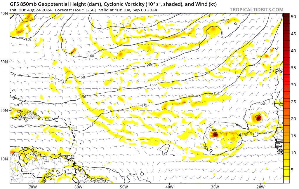
Teban54 wrote:10 days out of course, but it's almost as if GFS heard all the NS count cancel posts and decided to do something about it. (This is in addition to the Gulf system that intensified to 997 mb at landfall.)
https://i.postimg.cc/NfqNQZyb/gfs-z850-vort-eatl-44.png
This seems like GFS bias kicking in with vorticies so I don’t think it’s real BUT maybe it’s a sign it’s starting to get its act together wrt the monsoon trough breakdown?
0 likes
-
Stratton23
- Category 5
- Posts: 3518
- Joined: Fri Jul 21, 2023 10:59 pm
- Location: Katy, Tx
Re: 2024 Global Model Runs Discussion (Out thru day 16)
GEFS showing a decent signal for the western/ southern gulf in 8 days
0 likes
Re: 2024 Global Model Runs Discussion (Out thru day 16)
Pas_Bon wrote:At some point, we just have to call a spade a spade. No, the season isn’t “cancelled,” but it’s getting time that we need to really curtail our expectations of a “hyperactive” season, in my non-professional opinion.
We keep hearing, “the switch is going to flip any day now” and now “September will be a rough one.” This, after hearing, “August will be Hell.”
I’ll be honest, while I expect a few storms in September, I’m not seeing anything from the models indicating that we will see anything other than a few storms here and there.
The prognostications for this season were justified, indeed. They haven’t really panned out. We had a Cat 1 in Texas (granted, it reached Cat 5 and damaged Jamaica quite a bit) and a Cat 1 in Florida. Other than that, we’ve had a couple tropical storms and a (mostly) fish that impacted Bermuda. While that is active for whomever gets them, it’s hardly the doom and gloom that has had so many worried for so long.
Ernesto was far from a fish storm considering it impacted the Caribbean as well as Bermuda like you mentioned. A hyperactive season is still likely imo as we only need 105 ACE to get there but yes we might not get the 200+ ACE season that the forecasts suggested.
3 likes

Re: 2024 Global Model Runs Discussion (Out thru day 16)
MarioProtVI wrote:Teban54 wrote:10 days out of course, but it's almost as if GFS heard all the NS count cancel posts and decided to do something about it. (This is in addition to the Gulf system that intensified to 997 mb at landfall.)
https://i.postimg.cc/NfqNQZyb/gfs-z850-vort-eatl-44.png
This seems like GFS bias kicking in with vorticies so I don’t think it’s real BUT maybe it’s a sign it’s starting to get its act together wrt the monsoon trough breakdown?
If it's history with the CAG is any indication, the southwest vortex (if these are real) often wins out as, unless there's a trough, they tend to end up in the Pacific and go west
0 likes
The above post is not official and should not be used as such. It is the opinion of the poster and may or may not be backed by sound meteorological data. It is not endorsed by any professional institution or storm2k.org. For official information, please refer to the NHC and NWS products.
-
MarioProtVI
- Category 5
- Posts: 1034
- Age: 24
- Joined: Sun Sep 29, 2019 7:33 pm
- Location: New Jersey
Re: 2024 Global Model Runs Discussion (Out thru day 16)
Meant to post here, but 00z EURO is FINALLY starting to pick up the wave that AI-EURO, CMC, CFS and ensembles have been detecting. Uptrended quite a bit - previously was just strung out to hell and back but now is actually a coherent entity.

2 likes
-
jlauderdal
- S2K Supporter

- Posts: 7240
- Joined: Wed May 19, 2004 5:46 am
- Location: NE Fort Lauderdale
- Contact:
Re: 2024 Global Model Runs Discussion (Out thru day 16)
wxman57 wrote:I certainly like what I'm seeing in the models today - no significant development. I'm thinking that the next storm may form in the Subtropical Atlantic ENE of Bermuda in 7-10 days. Love it! Maybe I'll take next Thursday AND Friday off before the 3-day Labor Day weekend.
Here comes a Labor Day system that rivals 1935
2 likes
-
cycloneye

- Admin

- Posts: 149266
- Age: 69
- Joined: Thu Oct 10, 2002 10:54 am
- Location: San Juan, Puerto Rico
Re: 2024 Global Model Runs Discussion (Out thru day 16)
The Euro AIF model has been the most consistent model showing and developing something. Here is the 00z run with a difference as it moves much more west.

1 likes
Visit the Caribbean-Central America Weather Thread where you can find at first post web cams,radars
and observations from Caribbean basin members Click Here
and observations from Caribbean basin members Click Here

Re: 2024 Global Model Runs Discussion (Out thru day 16)
Stratton23 wrote:00z GFS again has another wave trying to develop in the gulf next week, thats been showing up on the last 3-4 runs now, interesting
Even the 00z CMC is starting to hint at this as well, albeit its much weaker and stretched out wave
https://www.tropicaltidbits.com/sat/sat ... uct=wv_mid
Mid level circulations typically take *days* to get down to the surface.
Texas could still get significant rain from a mid level feature if the thunderstorm activity picks up.
If we start seeing the surface pressures at the mid gulf buoy yoyo down below 1008 MB we might get a declared depression. And if a depression did form it could come northeast with the next front.
https://www.ndbc.noaa.gov/station_page. ... tion=42001
0 likes
Who is online
Users browsing this forum: Ulf and 185 guests