Tropical Storm Warning issued.
TCPCP1
BULLETIN
Tropical Storm Hone Advisory Number 7
NWS Central Pacific Hurricane Center Honolulu HI CP012024
500 PM HST Fri Aug 23 2024
...HONE CONTINUES WESTWARD TOWARD THE HAWAIIAN ISLANDS...
...TROPICAL STORM WARNING ISSUED FOR THE BIG ISLAND OF HAWAII...
SUMMARY OF 500 PM HST...0300 UTC...INFORMATION
----------------------------------------------
LOCATION...16.9N 149.3W
ABOUT 425 MI...685 KM ESE OF HILO HAWAII
ABOUT 640 MI...1025 KM ESE OF HONOLULU HAWAII
MAXIMUM SUSTAINED WINDS...50 MPH...85 KM/H
PRESENT MOVEMENT...W OR 280 DEGREES AT 16 MPH...26 KM/H
MINIMUM CENTRAL PRESSURE...1000 MB...29.53 INCHES
WATCHES AND WARNINGS
--------------------
CHANGES WITH THIS ADVISORY:
A Tropical Storm Warning has been issued for Hawaii County.
Tropical Storm Hone Discussion Number 7
NWS Central Pacific Hurricane Center Honolulu HI CP012024
500 PM HST Fri Aug 23 2024
The U.S. Air Force Reserve Hurricane Hunter aircraft sampled
Tropical Storm Hone from this morning into early afternoon and
provided valuable data. In spite of its lack of convection, Hone
maintained a well-developed low cloud field and remained
surprisingly intense through the morning, well above Dvorak inputs
from the fix agencies. Late this afternoon, deep convection is
redeveloping near the center as winds aloft ease. The latest data
from the Hurricane Hunters came in just before 00Z and showed
maximum sustained winds holding at 45 kt and a minimum sea level
pressure of 1000 mb. Given the appearance of Hone, these values
will be used for the initial intensity.
The initial motion is unchanged at 280/14. This general motion
toward slightly north of due west will continue during the next
several days as Hone is steered by a deep subtropical ridge to the
north. However, some slowing of the forward motion is anticipated
as the deep ridge to the north of Hone weakens slightly. Along this
track, Hone will be passing near or just south of the state late
Saturday into early Sunday, which necessitates the issuance of a
Tropical Storm Warning for the Big Island of Hawaii. By the middle
of next week, Hone will likely become increasingly shallow as
vertical wind shear increases, allowing the low level trade wind
flow to steer the system toward the west. The official forecast
track is nearly identical to the previous advisory, and closely
follows the tightly clustered consensus guidance near the TVCN.
Hone has a window for intensification during the next 36 to 48
hours. Easterly winds aloft, which have inhibited outflow in all
but the south and southwest quadrants, will relax tonight and
Saturday as a weakness develops in the upper level ridge north of
the cyclone. Sea surface temperatures will remain around 26-27C,
which will be sufficient for intensification, possibly to hurricane
strength, late Saturday or early Sunday. Late Sunday and Monday,
west to northwest vertical wind shear will increase sharply, which
should result in steady weakening. The intensity forecast remains
on the higher side of the guidance envelope near the HCCA and
slightly higher than the IVCN. Beyond 48 hours, the forecast closely
follows the IVCN.
KEY MESSAGES:
1. There is the potential for excessive rainfall and flash flooding
on portions of the Big Island of Hawaii starting later Saturday
and continuing through Sunday as a large area of moisture
associated with Hone moves over parts of the Hawaiian Islands. The
heaviest rainfall will likely occur over windward and southeast
facing slopes.
2. Tropical storm conditions are possible on the Big Island later
Saturday into Sunday. Winds are expected to be strongest where they
blow downslope from higher terrain, over headlands, and through
passes.
3. Swell generated by Hone is expected to reach the Hawaiian
islands Saturday night into Sunday. This swell could cause
life-threatening surf and rip currents. Listen for later advisories
and possible warnings from the National Weather Service.
FORECAST POSITIONS AND MAX WINDS
INIT 24/0300Z 16.9N 149.3W 45 KT 50 MPH
12H 24/1200Z 17.3N 151.4W 50 KT 60 MPH
24H 25/0000Z 17.6N 154.1W 55 KT 65 MPH
36H 25/1200Z 17.9N 156.4W 60 KT 70 MPH
48H 26/0000Z 18.2N 158.5W 65 KT 75 MPH
60H 26/1200Z 18.6N 160.6W 60 KT 70 MPH
72H 27/0000Z 19.0N 162.5W 55 KT 65 MPH
96H 28/0000Z 19.7N 165.7W 50 KT 60 MPH
120H 29/0000Z 20.4N 168.8W 35 KT 40 MPH
$$
Forecaster Wroe
WPAC: HONE - Post-Tropical - Discussion
Moderator: S2k Moderators
-
cycloneye

- Admin

- Posts: 149730
- Age: 69
- Joined: Thu Oct 10, 2002 10:54 am
- Location: San Juan, Puerto Rico
Re: CPAC: HONE - Tropical Storm - Discussion
0 likes
Visit the Caribbean-Central America Weather Thread where you can find at first post web cams,radars
and observations from Caribbean basin members Click Here
and observations from Caribbean basin members Click Here
-
Kingarabian

- S2K Supporter

- Posts: 16379
- Joined: Sat Aug 08, 2009 3:06 am
- Location: Honolulu, Hawaii
Re: CPAC: HONE - Tropical Storm - Discussion
Deep convection as well as banding is back.
0 likes
RIP Kobe Bryant
-
Kingarabian
- S2K Supporter
- Posts: 16379
- Joined: Sat Aug 08, 2009 3:06 am
- Location: Honolulu, Hawaii
Re: CPAC: HONE - Tropical Storm - Discussion
Looks like models are accounting for a deeper vortex. Pretty good shifts north on the 00z and now the 06z global model runs. Kona and Puna areas on Hawaii Island could see much more impacts.
Last edited by Kingarabian on Sat Aug 24, 2024 5:19 am, edited 2 times in total.
0 likes
RIP Kobe Bryant
-
Kingarabian
- S2K Supporter
- Posts: 16379
- Joined: Sat Aug 08, 2009 3:06 am
- Location: Honolulu, Hawaii
-
Kingarabian
- S2K Supporter
- Posts: 16379
- Joined: Sat Aug 08, 2009 3:06 am
- Location: Honolulu, Hawaii
Re: CPAC: HONE - Tropical Storm - Discussion
000
WTPA41 PHFO 240902
TCDCP1
Tropical Storm Hone Discussion Number 8
NWS Central Pacific Hurricane Center Honolulu HI CP012024
1100 PM HST Fri Aug 23 2024
The appearance of Tropical Storm Hone has improved significantly
from earlier this afternoon, with deep convection over the low-level
circulation center and convective banding nearly encircling the
storm. The latest Subjective Dvorak intensity estimates came in
at 2.5 from all fix agencies with UW-CIMSS ADT and AiDT coming in at
32 and 36 knots respectively. Valuable information was received from
a U.S. Air Force Reserve Hurricane Hunter aircraft which sampled
Hone once again this evening. The aircraft sampled maximum sustained
flight level winds of 56 knots, which reduces to 50 knots at the
surface, max SFMR winds of 43 knots, and maximum MBL winds of 54
knots, which reduces to 45 knots at the surface. Taking a blend of
these data and accounting for the improvement in structure of the
system, the initial intensity will be increased to 50 knots with
this advisory package. The central pressure of Hone was lowered to
998 mb due to dropsonde data obtained by the aircraft.
The initial motion has shifted a bit further north of due west, and
is set at 285/12 for this advisory. This general motion, slightly
north of due west, will continue during the next several days as
Hone is steered by a deep subtropical ridge to the north. However,
some slowing of the forward motion is expected as the deep ridge to
the north of Hone weakens slightly. Along this track, Hone will be
passing near or just south of the Big Island of Hawaii late Saturday
into early Sunday, and a Tropical Storm Warning remains in effect
for the Big Island of Hawaii. By the middle of next week, Hone will
likely become increasingly shallow as vertical wind shear increases,
allowing the low level trade wind flow to steer the system toward
the west. The official forecast track has been nudged a bit north of
the previous advisory due to the recent movement trends of the
system, and closely follows the tightly clustered consensus
guidance.
Environmental conditions will change little during the next 24
hours, with sea surface temperatures between 26C and 27C, light to
moderate vertical wind shear, and marginally sufficient mid-level
moisture. As a result, the forecast calls for continued slow
strengthening. Beyond 24 hours, sea surface temperatures increase
to around 27C and ocean heat content becomes more favorable as
well. This should allow Hone to reach Hurricane strength Sunday
through Monday, before increasing vertical wind shear weakens the
system Monday night through the middle of next week. The intensity
forecast follows dynamical consensus guidance closely and is
similar to the previous advisory package.
KEY MESSAGES:
1. There is the potential for excessive rainfall and flash flooding
on portions of the Big Island of Hawaii starting Saturday afternoon
and continuing through Sunday as a large area of moisture
associated with Hone moves over parts of the Hawaiian Islands. The
heaviest rainfall will likely occur over windward and southeast
facing slopes.
2. Tropical storm conditions are possible on the Big Island
Saturday afternoon into Sunday. Winds are expected to be strongest
where they blow downslope from higher terrain, over headlands, and
through passes.
3. Swell generated by Hone is expected to reach the Hawaiian
islands later tonight, then spread to the remainder of the state
through the rest of the weekend. These swells will produce
life-threatening surf and rip currents. Listen for later advisories
and possible warnings from the National Weather Service.
FORECAST POSITIONS AND MAX WINDS
INIT 24/0900Z 17.4N 150.5W 50 KT 60 MPH
12H 24/1800Z 17.7N 152.6W 55 KT 65 MPH
24H 25/0600Z 17.9N 154.9W 60 KT 70 MPH
36H 25/1800Z 18.3N 157.1W 65 KT 75 MPH
48H 26/0600Z 18.7N 159.2W 65 KT 75 MPH
60H 26/1800Z 19.0N 161.1W 65 KT 75 MPH
72H 27/0600Z 19.4N 162.9W 60 KT 70 MPH
96H 28/0600Z 20.0N 166.5W 45 KT 50 MPH
120H 29/0600Z 20.6N 170.5W 35 KT 40 MPH
$$
Forecaster Jelsema
0 likes
RIP Kobe Bryant
-
Kingarabian
- S2K Supporter
- Posts: 16379
- Joined: Sat Aug 08, 2009 3:06 am
- Location: Honolulu, Hawaii
Re: CPAC: HONE - Tropical Storm - Discussion
Latest recon supports 55-60kts.
0 likes
RIP Kobe Bryant
-
cycloneye
- Admin
- Posts: 149730
- Age: 69
- Joined: Thu Oct 10, 2002 10:54 am
- Location: San Juan, Puerto Rico
Re: CPAC: HONE - Tropical Storm - Discussion
BULLETIN
Tropical Storm Hone Intermediate Advisory Number 8A
NWS Central Pacific Hurricane Center Honolulu HI CP012024
200 AM HST Sat Aug 24 2024
...HONE STRENGTHENS SLIGHTLY AS IT CONTINUES WESTWARD TOWARD
HAWAII...
...TROPICAL STORM WARNING REMAINS IN EFFECT FOR THE BIG ISLAND...
SUMMARY OF 200 AM HST...1200 UTC...INFORMATION
----------------------------------------------
LOCATION...17.5N 151.3W
ABOUT 290 MI...465 KM ESE OF HILO HAWAII
ABOUT 500 MI...805 KM ESE OF HONOLULU HAWAII
MAXIMUM SUSTAINED WINDS...65 MPH...105 KM/H
PRESENT MOVEMENT...WNW OR 280 DEGREES AT 15 MPH...24 KM/H
MINIMUM CENTRAL PRESSURE...998 MB...29.47 INCHES
0 likes
Visit the Caribbean-Central America Weather Thread where you can find at first post web cams,radars
and observations from Caribbean basin members Click Here
and observations from Caribbean basin members Click Here

Re: CPAC: HONE - Tropical Storm - Discussion
I wonder if this would cross 180E while still being classified as a TC...
0 likes
ヤンデレ女が寝取られるているのを見たい!!!
ECMWF ensemble NWPAC plots: https://ecmwfensnwpac.imgbb.com/
Multimodel NWPAC plots: https://multimodelnwpac.imgbb.com/
GFS Ensemble NWPAC plots (16 & 35 day forecast): https://gefsnwpac.imgbb.com/
Plots updated automatically
ECMWF ensemble NWPAC plots: https://ecmwfensnwpac.imgbb.com/
Multimodel NWPAC plots: https://multimodelnwpac.imgbb.com/
GFS Ensemble NWPAC plots (16 & 35 day forecast): https://gefsnwpac.imgbb.com/
Plots updated automatically
-
Kingarabian
- S2K Supporter
- Posts: 16379
- Joined: Sat Aug 08, 2009 3:06 am
- Location: Honolulu, Hawaii
Re: CPAC: HONE - Tropical Storm - Discussion
Hayabusa wrote:I wonder if this would cross 180E while still being classified as a TC...
Models were hinting on either this or Gilma making it to 180E, about 4 days ago. But have backed off. I think it's a good possibility one of them do.
0 likes
RIP Kobe Bryant
-
Kingarabian
- S2K Supporter
- Posts: 16379
- Joined: Sat Aug 08, 2009 3:06 am
- Location: Honolulu, Hawaii
Re: CPAC: HONE - Tropical Storm - Discussion
They should do Hurricane Watches for the Big Island. Hurricane models showing the potential for Kona to receive winds in excess of 65kts.
1 likes
RIP Kobe Bryant
-
cycloneye
- Admin
- Posts: 149730
- Age: 69
- Joined: Thu Oct 10, 2002 10:54 am
- Location: San Juan, Puerto Rico
Re: CPAC: HONE - Tropical Storm - Discussion
Tropical Storm Hone Discussion Number 9
NWS Central Pacific Hurricane Center Honolulu HI CP012024
500 AM HST Sat Aug 24 2024
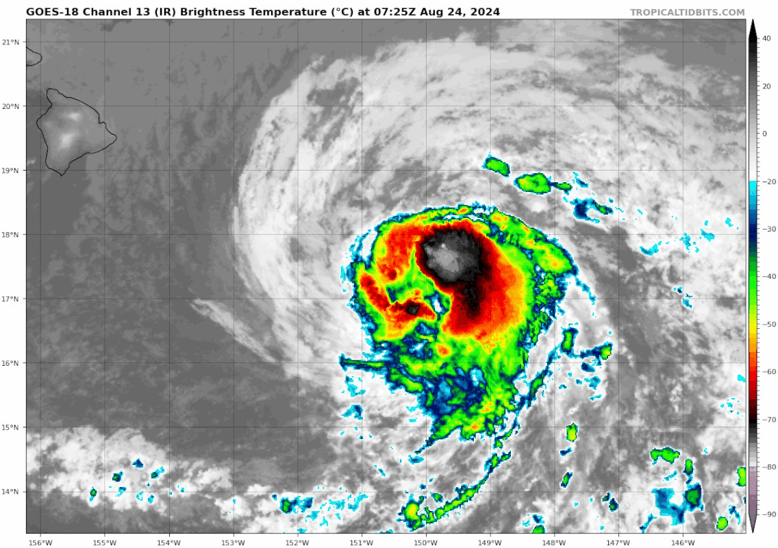
Satellite imagery indicates that the appearance of Tropical Storm
Hone remains steady, with minimal changes in track or intensity
over the past 6 h. Deep convection and convective banding continue
to present a well-organized structure. Recent data from a U.S. Air
Force Reserve Hurricane Hunter aircraft showed maximum sustained
flight-level winds of 64 knots, which, after adjustment, reduces to
51 knots at the surface. SFMR winds were recorded at 59 knots.
Considering these observations, the initial intensity will be
maintained at 55 knots. The central pressure remains at 998 mb as
confirmed by dropsonde data.
The initial motion is set at 280/13. This general motion, slightly
north of due west, is expected to continue over the next several
days under the influence of a subtropical ridge to the north. Some
slowing of forward motion is anticipated as the ridge weakens
slightly. Hone is expected to pass near or just south of the Big
Island of Hawaii later today through early Sunday, where a Tropical
Storm Warning remains in effect. By the middle of next week, Hone
will likely become increasingly shallow as vertical wind shear
increases, allowing the low-level trade wind flow to steer the
system toward the west-southwest. The official forecast track is
nearly identical to the previous advisory, and closely follows the
tightly clustered consensus guidance.
Environmental conditions are expected to remain steady over the next
24 h, with sea surface temperatures between 26C and 27C, light to
moderate vertical wind shear, and marginally sufficient mid-level
moisture. Slow strengthening is expected to continue. Sea surface
temperatures are forecast to rise to around 27C beyond 24 h, and
oceanic heat content will become more favorable. This supports the
potential for Hone to reach hurricane strength from Sunday through
Monday. As Hone continues westward, increasing vertical wind shear
is likely to weaken the system later Monday through the middle of
next week. The intensity forecast is aligned with dynamical
consensus guidance.
KEY MESSAGES:
1. There is the potential for excessive rainfall and flash flooding
on portions of the Big Island of Hawaii starting this afternoon and
continuing through Sunday as a large area of moisture associated
with Hone moves through. The heaviest rainfall will likely occur
over windward and southeast facing slopes.
2. Tropical Storm conditions are expected on the Big Island,
beginning as early as this evening and continuing through early
Sunday. Winds are expected to be strongest downslope of higher
terrain, over headlands, and through passes.
3. Surf associated with large swells generated by Hone will quickly
build today through Sunday as Hone continues westward. Expect
dangerous conditions with life-threatening surf and rip currents.
FORECAST POSITIONS AND MAX WINDS
INIT 24/1500Z 17.5N 151.9W 55 KT 65 MPH
12H 25/0000Z 17.8N 153.8W 55 KT 65 MPH
24H 25/1200Z 18.1N 156.0W 60 KT 70 MPH
36H 26/0000Z 18.5N 158.2W 65 KT 75 MPH
48H 26/1200Z 18.9N 160.3W 65 KT 75 MPH
60H 27/0000Z 19.2N 162.2W 60 KT 70 MPH
72H 27/1200Z 19.5N 164.0W 55 KT 65 MPH
96H 28/1200Z 20.2N 167.4W 45 KT 50 MPH
120H 29/1200Z 20.8N 170.2W 35 KT 40 MPH
$$
Forecaster Jelsema/Gibbs
NWS Central Pacific Hurricane Center Honolulu HI CP012024
500 AM HST Sat Aug 24 2024
Satellite imagery indicates that the appearance of Tropical Storm
Hone remains steady, with minimal changes in track or intensity
over the past 6 h. Deep convection and convective banding continue
to present a well-organized structure. Recent data from a U.S. Air
Force Reserve Hurricane Hunter aircraft showed maximum sustained
flight-level winds of 64 knots, which, after adjustment, reduces to
51 knots at the surface. SFMR winds were recorded at 59 knots.
Considering these observations, the initial intensity will be
maintained at 55 knots. The central pressure remains at 998 mb as
confirmed by dropsonde data.
The initial motion is set at 280/13. This general motion, slightly
north of due west, is expected to continue over the next several
days under the influence of a subtropical ridge to the north. Some
slowing of forward motion is anticipated as the ridge weakens
slightly. Hone is expected to pass near or just south of the Big
Island of Hawaii later today through early Sunday, where a Tropical
Storm Warning remains in effect. By the middle of next week, Hone
will likely become increasingly shallow as vertical wind shear
increases, allowing the low-level trade wind flow to steer the
system toward the west-southwest. The official forecast track is
nearly identical to the previous advisory, and closely follows the
tightly clustered consensus guidance.
Environmental conditions are expected to remain steady over the next
24 h, with sea surface temperatures between 26C and 27C, light to
moderate vertical wind shear, and marginally sufficient mid-level
moisture. Slow strengthening is expected to continue. Sea surface
temperatures are forecast to rise to around 27C beyond 24 h, and
oceanic heat content will become more favorable. This supports the
potential for Hone to reach hurricane strength from Sunday through
Monday. As Hone continues westward, increasing vertical wind shear
is likely to weaken the system later Monday through the middle of
next week. The intensity forecast is aligned with dynamical
consensus guidance.
KEY MESSAGES:
1. There is the potential for excessive rainfall and flash flooding
on portions of the Big Island of Hawaii starting this afternoon and
continuing through Sunday as a large area of moisture associated
with Hone moves through. The heaviest rainfall will likely occur
over windward and southeast facing slopes.
2. Tropical Storm conditions are expected on the Big Island,
beginning as early as this evening and continuing through early
Sunday. Winds are expected to be strongest downslope of higher
terrain, over headlands, and through passes.
3. Surf associated with large swells generated by Hone will quickly
build today through Sunday as Hone continues westward. Expect
dangerous conditions with life-threatening surf and rip currents.
FORECAST POSITIONS AND MAX WINDS
INIT 24/1500Z 17.5N 151.9W 55 KT 65 MPH
12H 25/0000Z 17.8N 153.8W 55 KT 65 MPH
24H 25/1200Z 18.1N 156.0W 60 KT 70 MPH
36H 26/0000Z 18.5N 158.2W 65 KT 75 MPH
48H 26/1200Z 18.9N 160.3W 65 KT 75 MPH
60H 27/0000Z 19.2N 162.2W 60 KT 70 MPH
72H 27/1200Z 19.5N 164.0W 55 KT 65 MPH
96H 28/1200Z 20.2N 167.4W 45 KT 50 MPH
120H 29/1200Z 20.8N 170.2W 35 KT 40 MPH
$$
Forecaster Jelsema/Gibbs
0 likes
Visit the Caribbean-Central America Weather Thread where you can find at first post web cams,radars
and observations from Caribbean basin members Click Here
and observations from Caribbean basin members Click Here
-
Sciencerocks
- Category 5

- Posts: 10193
- Age: 40
- Joined: Thu Jul 06, 2017 1:51 am

-
cycloneye
- Admin
- Posts: 149730
- Age: 69
- Joined: Thu Oct 10, 2002 10:54 am
- Location: San Juan, Puerto Rico
Re: CPAC: HONE - Tropical Storm - Discussion
Tropical Storm Hone Discussion Number 10
NWS Central Pacific Hurricane Center Honolulu HI CP012024
1100 AM HST Sat Aug 24 2024
Cloud tops around Tropical Storm Hone have warmed noticeably
since the overnight convective bloom, but satellite loop shows
overall structure remained steady over the past six hours. Movement
remains steady as well as the intermediate position at 18Z was
exactly along the overnight forecast track. Latest data from U.S.
Air Force Reserve Hurricane Hunter aircraft showed maximum
sustained winds of 51 knots. This is slightly higher than subjective
Dvorak satellite derived intensities of 45 kt from CPHC and JTWC.
Direct observations take precedence and the initial intensity for
Hone will be maintained at 55 kt. A dropsonde measured a central
pressure of 1000 mb, a slight increase from last night.
The initial motion is set at 280/13, unchanged from the last full
forecast cycle. Slightly north of due west, this motion is expected
to continue over the next several days due to the influence of a
subtropical ridge to the north. Some slowing in forward motion
is anticipated as the ridge weakens slightly. Hone is expected to
pass near or just south of the Big Island of Hawaii later today
through early Sunday, where a Tropical Storm Warning remains in
effect. By the middle of the coming week, Hone will likely become
increasingly shallow as vertical wind shear increases, allowing
low-level trade wind flow to steer the system toward the
west-southwest. The official forecast track is nearly identical to
the previous advisory and closely follows the tightly clustered
consensus guidance.
Environmental conditions affecting Hone will remain steady over the
next 24 hours, with sea surface temperatures between 26C and 27C,
light to moderate vertical wind shear, and marginally sufficient
mid-level moisture. Slow strengthening is expected to continue
through tonight. Sea surface temperatures are forecast to rise to
around 27C beyond 24 hr. However, guidance presents a rather
compelling case for capping Hone's intensity at 60 kt Sunday and
Monday, just below hurricane strength. As Hone continues westward,
increasing vertical wind shear may weaken it later Monday through
the middle of next week. The intensity forecast closely follows
dynamical consensus guidance.
KEY MESSAGES:
1. There is the potential for excessive rainfall and flash flooding
on portions of the Big Island of Hawaii starting this afternoon and
continuing through Sunday as a large area of moisture associated
with Hone moves through. The heaviest rainfall will likely occur
over windward and southeast facing slopes.
2. Tropical Storm conditions are expected on the Big Island,
beginning as early as this evening and continuing through early
Sunday. Winds are expected to be strongest downslope of higher
terrain, over headlands, and through passes.
3. Swells generated by Hone will impact the Hawaiian islands
through Sunday, creating life-threatening surf and rip currents.
Please consult surf products from the National Weather Service in
Honolulu.
FORECAST POSITIONS AND MAX WINDS
INIT 24/2100Z 17.7N 153.2W 55 KT 65 MPH
12H 25/0600Z 18.1N 155.1W 55 KT 65 MPH
24H 25/1800Z 18.5N 157.3W 60 KT 70 MPH
36H 26/0600Z 18.8N 159.6W 60 KT 70 MPH
48H 26/1800Z 19.0N 161.8W 60 KT 70 MPH
60H 27/0600Z 19.3N 163.8W 55 KT 65 MPH
72H 27/1800Z 19.5N 165.6W 50 KT 60 MPH
96H 28/1800Z 20.2N 168.8W 40 KT 45 MPH
120H 29/1800Z 21.3N 172.0W 30 KT 35 MPH
$$
Forecaster Powell
0 likes
Visit the Caribbean-Central America Weather Thread where you can find at first post web cams,radars
and observations from Caribbean basin members Click Here
and observations from Caribbean basin members Click Here
-
cycloneye
- Admin
- Posts: 149730
- Age: 69
- Joined: Thu Oct 10, 2002 10:54 am
- Location: San Juan, Puerto Rico
Re: CPAC: HONE - Tropical Storm - Discussion
Tropical Storm Hone Discussion Number 11
NWS Central Pacific Hurricane Center Honolulu HI CP012024
500 PM HST Sat Aug 24 2024
After briefly becoming exposed, the low level circulation center of
Hone has become obscured by deep convection once again late this
afternoon. Overall organization remains steady, while motion has
slowed a bit and deviated very slightly right of track over the
past six hours. Latest data from U.S. Air Force Reserve Hurricane
Hunter aircraft showed maximum sustained winds of 51 knots, reduced
from flight level. This is slightly higher than subjective Dvorak
satellite derived intensities of 45 kt from CPHC and JTWC.
Reconnaissance values take precedence and the initial intensity for
Hone will be maintained at 55 kt. Initial pressure will remain 1000
mb.
The initial motion is set at 280/12, slightly slower than the
last two forecast cycles. A bit north of due west, this general
motion is expected to continue over the next several days under the
influence of a subtropical ridge to the north. Some forward motion
slowing is anticipated as the ridge weakens slightly. Hone is
expected to pass near or just south of the Big Island of Hawaii this
evening through early Sunday, where a Tropical Storm Warning remains
in effect. By the middle of the coming week, Hone will likely become
increasingly shallow as vertical wind shear increases, allowing the
low-level trade wind flow to steer the system toward the
west-southwest. The official forecast track is nearly identical to
the previous advisory, and closely follows the tightly clustered
consensus guidance.
Expect sea surface temperatures between 26C and 27C, light to
moderate vertical wind shear, and marginally sufficient mid-level
moisture along Hone's path. Slow strengthening will continue
into Sunday tonight. While sea surface temperatures are forecast to
rise to around 27C beyond 24 hours, guidance continues to present a
rather compelling case for capping Hone intensity at 60 kt Sunday
and Monday, just below hurricane strength. As Hone continues
westward, increasing vertical wind shear may weaken it later Monday
through the middle of next week. The intensity forecast closely
follows dynamical consensus guidance.
KEY MESSAGES:
1. The potential for excessive rainfall and flash flooding on
portions of the Big Island of Hawaii persists through Sunday as a
large area of moisture associated with Hone moves through. The
heaviest rainfall will likely occur over windward and southeast
facing slopes.
2. Tropical Storm conditions are expected on the Big Island
beginning this evening and continuing through early Sunday. Winds
are expected to be strongest downslope of higher terrain, over
headlands, and through passes.
3. Swells generated by Hone will continue through Sunday as this
system continues westward. Expect dangerous conditions with
life-threatening surf and rip currents.
FORECAST POSITIONS AND MAX WINDS
INIT 25/0300Z 18.0N 154.4W 55 KT 65 MPH
12H 25/1200Z 18.4N 156.2W 55 KT 65 MPH
24H 26/0000Z 18.8N 158.4W 60 KT 70 MPH
36H 26/1200Z 19.0N 160.6W 60 KT 70 MPH
48H 27/0000Z 19.2N 162.7W 55 KT 65 MPH
60H 27/1200Z 19.4N 164.6W 50 KT 60 MPH
72H 28/0000Z 19.7N 166.4W 45 KT 50 MPH
96H 29/0000Z 20.5N 169.6W 35 KT 40 MPH
120H 30/0000Z 21.4N 172.9W 30 KT 35 MPH
$$
Forecaster Powell
0 likes
Visit the Caribbean-Central America Weather Thread where you can find at first post web cams,radars
and observations from Caribbean basin members Click Here
and observations from Caribbean basin members Click Here
-
Kingarabian
- S2K Supporter
- Posts: 16379
- Joined: Sat Aug 08, 2009 3:06 am
- Location: Honolulu, Hawaii
Re: CPAC: HONE - Tropical Storm - Discussion
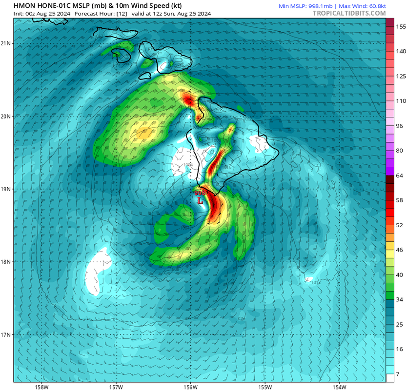
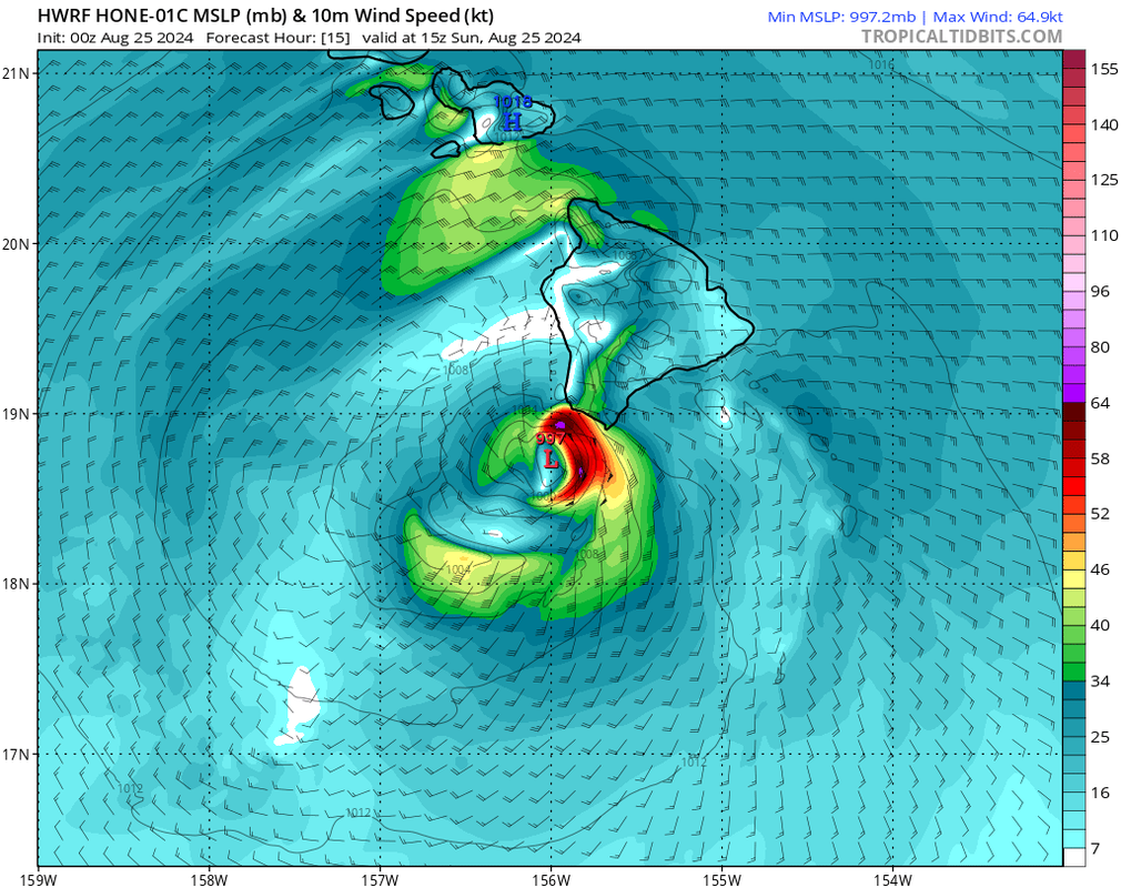
https://i.postimg.cc/QxVRbPm5/goes18-ir ... 250225.gif
Looks like the center will miss the south tip of the Big Island of Hawaii by about 20-50 miles. Unfortunately the bulk of the action is east and NE of the center and most of it will hit the island.
HMON:
HWRF:
0 likes
RIP Kobe Bryant
-
Yellow Evan

- Professional-Met

- Posts: 16257
- Age: 27
- Joined: Fri Jul 15, 2011 12:48 pm
- Location: Henderson, Nevada/Honolulu, HI
- Contact:
Re: CPAC: HONE - Tropical Storm - Discussion
Not sure why this isn't a hurricane. FL, SFMR, and sondes all support it.
0 likes
-
ElectricStorm

- Category 5
- Posts: 5156
- Age: 25
- Joined: Tue Aug 13, 2019 11:23 pm
- Location: Norman, OK
Re: CPAC: HONE - Tropical Storm - Discussion
01C HONE 240825 0600 18.1N 154.8W CPAC 65 991
0 likes
B.S Meteorology, University of Oklahoma '25
Please refer to the NHC, NWS, or SPC for official information.
Please refer to the NHC, NWS, or SPC for official information.
-
cycloneye
- Admin
- Posts: 149730
- Age: 69
- Joined: Thu Oct 10, 2002 10:54 am
- Location: San Juan, Puerto Rico
Re: CPAC: HONE - Hurricane - Discussion
Hurricane Hone Discussion Number 12
NWS Central Pacific Hurricane Center Honolulu HI CP012024
1100 PM HST Sat Aug 24 2024
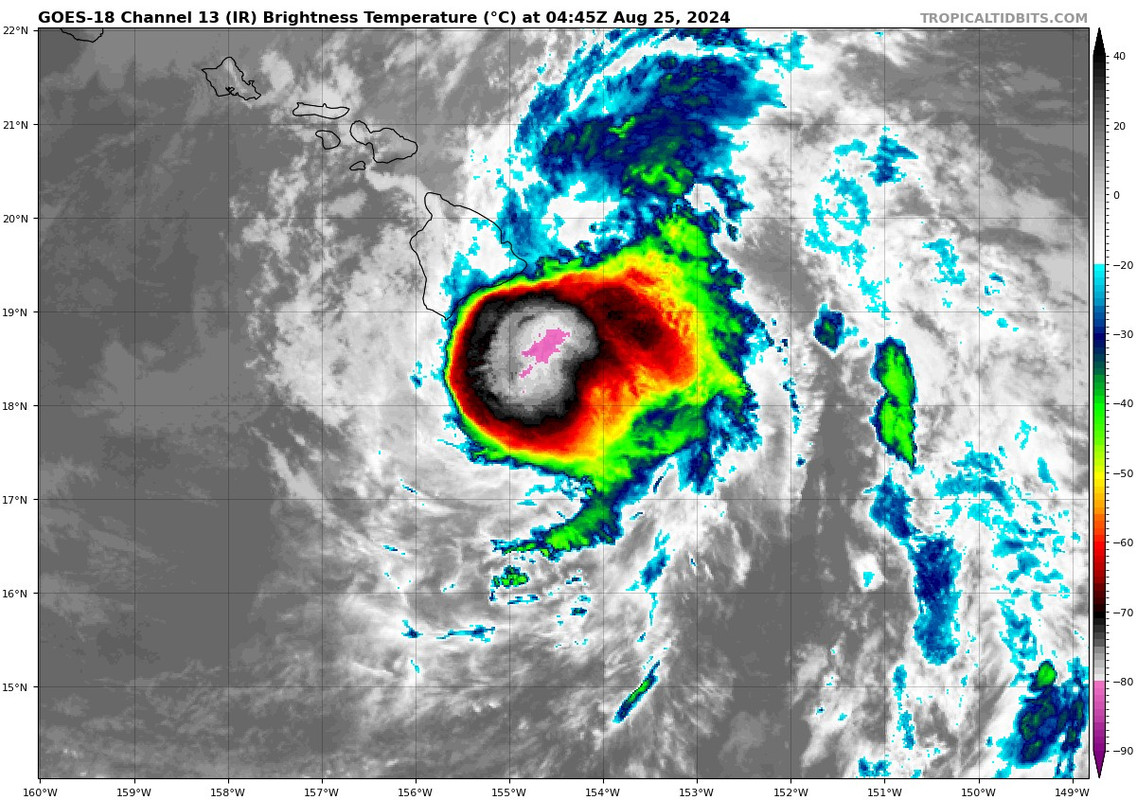
Hone is passing by around 50 nautical miles south of South Point on
the Big Island of Hawaii this evening, where it is within radar
range. Combined radar and data from the Air Force Reserve
reconnaissance aircraft support raising the intensity to 65 knots,
making Hone a Category 1 Hurricane. Despite recent subjective Dvorak
estimates suggesting a slightly lower intensity, the satellite
presentation has evolved markedly from this afternoon, with cold
cloud tops near -80 C reinforcing the aircraft-based intensity.
Additionally, a dropsonde report measured a central pressure of 991
mb, depicting a significant decrease from this afternoon. The
initial intensity is raised to 65 kt for this advisory.
The initial motion of Hone is set at 280/10, consistent with the
previous forecast cycle. This slightly north of due west trajectory
is expected to persist over the coming days, influenced by the
subtropical ridge to the north. However, as Hone passes near the Big
Island overnight into Sunday, the mountainous terrain could
influence local steering currents, potentially leading to localized
and short-term deviations in the storm's motion and intensity. A
gradual slowing in forward speed is anticipated Sunday into Monday
as the ridge weakens slightly. As we move into the early to mid
portion of the week, Hone is projected to encounter increasing
vertical wind shear, which is expected to weaken the storm and make
it more shallow. This change in conditions will allow the low-level
trade wind flow to steer the system toward the west-southwest. The
official forecast track remains nearly identical to the previous
advisory and is closely aligned with the tightly clustered consensus
guidance.
Environmental conditions affecting Hone will remain steady over the
next 24 h, with sea surface temperatures between 26 C and 27 C,
light to moderate vertical wind shear, and sufficient mid-level
moisture. This supports maintaining a steady trend through Sunday.
Although sea surface temperatures are forecast to rise to around 27
C Sunday night and beyond as Hone continues westward, increasing
vertical wind shear will gradually weaken the storm Sunday night
through the middle of next week. The intensity forecast closely
follows dynamical consensus guidance.
KEY MESSAGES:
1. Tropical Storm conditions are expected on the Big Island
beginning through early Sunday. Winds are expected to be strongest
downslope of higher terrain, over headlands, and through passes.
2. Hone is expected to produce storm total rainfall of 6 to 12
inches over mainly windward and southeast facing slopes of the Big
Island, with locally higher amounts possible. Rainfall totals of 2
to 4 inches will be possible over portions of the smaller islands,
mainly windward.
3. Swells generated by Hone will continue through Sunday as this
system continues westward. Expect dangerous conditions with
life-threatening surf and rip currents.
FORECAST POSITIONS AND MAX WINDS
INIT 25/0900Z 18.2N 155.3W 65 KT 75 MPH
12H 25/1800Z 18.6N 157.0W 65 KT 75 MPH
24H 26/0600Z 19.0N 159.2W 60 KT 70 MPH
36H 26/1800Z 19.2N 161.4W 55 KT 65 MPH
48H 27/0600Z 19.3N 163.6W 50 KT 60 MPH
60H 27/1800Z 19.6N 166.0W 50 KT 60 MPH
72H 28/0600Z 19.9N 167.9W 45 KT 50 MPH
96H 29/0600Z 20.7N 171.1W 35 KT 40 MPH
120H 30/0600Z 21.2N 174.4W 30 KT 35 MPH
$$
Forecaster Jelsema/Gibbs
NWS Central Pacific Hurricane Center Honolulu HI CP012024
1100 PM HST Sat Aug 24 2024
Hone is passing by around 50 nautical miles south of South Point on
the Big Island of Hawaii this evening, where it is within radar
range. Combined radar and data from the Air Force Reserve
reconnaissance aircraft support raising the intensity to 65 knots,
making Hone a Category 1 Hurricane. Despite recent subjective Dvorak
estimates suggesting a slightly lower intensity, the satellite
presentation has evolved markedly from this afternoon, with cold
cloud tops near -80 C reinforcing the aircraft-based intensity.
Additionally, a dropsonde report measured a central pressure of 991
mb, depicting a significant decrease from this afternoon. The
initial intensity is raised to 65 kt for this advisory.
The initial motion of Hone is set at 280/10, consistent with the
previous forecast cycle. This slightly north of due west trajectory
is expected to persist over the coming days, influenced by the
subtropical ridge to the north. However, as Hone passes near the Big
Island overnight into Sunday, the mountainous terrain could
influence local steering currents, potentially leading to localized
and short-term deviations in the storm's motion and intensity. A
gradual slowing in forward speed is anticipated Sunday into Monday
as the ridge weakens slightly. As we move into the early to mid
portion of the week, Hone is projected to encounter increasing
vertical wind shear, which is expected to weaken the storm and make
it more shallow. This change in conditions will allow the low-level
trade wind flow to steer the system toward the west-southwest. The
official forecast track remains nearly identical to the previous
advisory and is closely aligned with the tightly clustered consensus
guidance.
Environmental conditions affecting Hone will remain steady over the
next 24 h, with sea surface temperatures between 26 C and 27 C,
light to moderate vertical wind shear, and sufficient mid-level
moisture. This supports maintaining a steady trend through Sunday.
Although sea surface temperatures are forecast to rise to around 27
C Sunday night and beyond as Hone continues westward, increasing
vertical wind shear will gradually weaken the storm Sunday night
through the middle of next week. The intensity forecast closely
follows dynamical consensus guidance.
KEY MESSAGES:
1. Tropical Storm conditions are expected on the Big Island
beginning through early Sunday. Winds are expected to be strongest
downslope of higher terrain, over headlands, and through passes.
2. Hone is expected to produce storm total rainfall of 6 to 12
inches over mainly windward and southeast facing slopes of the Big
Island, with locally higher amounts possible. Rainfall totals of 2
to 4 inches will be possible over portions of the smaller islands,
mainly windward.
3. Swells generated by Hone will continue through Sunday as this
system continues westward. Expect dangerous conditions with
life-threatening surf and rip currents.
FORECAST POSITIONS AND MAX WINDS
INIT 25/0900Z 18.2N 155.3W 65 KT 75 MPH
12H 25/1800Z 18.6N 157.0W 65 KT 75 MPH
24H 26/0600Z 19.0N 159.2W 60 KT 70 MPH
36H 26/1800Z 19.2N 161.4W 55 KT 65 MPH
48H 27/0600Z 19.3N 163.6W 50 KT 60 MPH
60H 27/1800Z 19.6N 166.0W 50 KT 60 MPH
72H 28/0600Z 19.9N 167.9W 45 KT 50 MPH
96H 29/0600Z 20.7N 171.1W 35 KT 40 MPH
120H 30/0600Z 21.2N 174.4W 30 KT 35 MPH
$$
Forecaster Jelsema/Gibbs
0 likes
Visit the Caribbean-Central America Weather Thread where you can find at first post web cams,radars
and observations from Caribbean basin members Click Here
and observations from Caribbean basin members Click Here
-
Sciencerocks
- Category 5
- Posts: 10193
- Age: 40
- Joined: Thu Jul 06, 2017 1:51 am

-
cycloneye
- Admin
- Posts: 149730
- Age: 69
- Joined: Thu Oct 10, 2002 10:54 am
- Location: San Juan, Puerto Rico
Re: CPAC: HONE - Hurricane - Discussion
0 likes
Visit the Caribbean-Central America Weather Thread where you can find at first post web cams,radars
and observations from Caribbean basin members Click Here
and observations from Caribbean basin members Click Here
Who is online
Users browsing this forum: No registered users and 67 guests