
2024 Global Model Runs Discussion (Out thru day 16)
Moderator: S2k Moderators
Forum rules

The posts in this forum are NOT official forecasts and should not be used as such. They are just the opinion of the poster and may or may not be backed by sound meteorological data. They are NOT endorsed by any professional institution or STORM2K. For official information, please refer to products from the National Hurricane Center and National Weather Service.
-
cycloneye

- Admin

- Posts: 149266
- Age: 69
- Joined: Thu Oct 10, 2002 10:54 am
- Location: San Juan, Puerto Rico
Re: 2024 Global Model Runs Discussion (Out thru day 16)
This is the grim look from GFS for September 10th that is peak season day. You would expect at least one or two areas of interest on the basin that date, but for now nothing. Let's see if GFS and other models change to more bullish in the next couple of weeks.
1 likes
Visit the Caribbean-Central America Weather Thread where you can find at first post web cams,radars
and observations from Caribbean basin members Click Here
and observations from Caribbean basin members Click Here
-
gatorcane

- S2K Supporter

- Posts: 23708
- Age: 48
- Joined: Sun Mar 13, 2005 3:54 pm
- Location: Boca Raton, FL
Re: 2024 Global Model Runs Discussion (Out thru day 16)
And this is the GFS wind shear forecast as we approach the peak. Looks quite hostile but I am skeptical it will really end up looking like that:
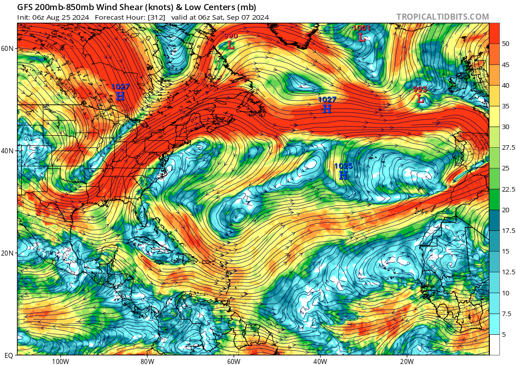
3 likes
-
otowntiger
- Category 5

- Posts: 1932
- Joined: Tue Aug 31, 2004 7:06 pm
Re: 2024 Global Model Runs Discussion (Out thru day 16)
cycloneye wrote:This is the grim look from GFS for September 10th that is peak season day. You would expect at least one or two areas of interest on the basin that date, but for now nothing. Let's see if GFS and other models change to more bullish in the next couple of weeks.
https://i.imgur.com/zJru6KE.png
You mean “grim” in best possible way, right?

3 likes
-
cajungal
- Category 5
- Posts: 2354
- Age: 49
- Joined: Sun Mar 14, 2004 9:34 pm
- Location: Schriever, Louisiana (60 miles southwest of New Orleans)
Re: 2024 Global Model Runs Discussion (Out thru day 16)
cycloneye wrote:This is the grim look from GFS for September 10th that is peak season day. You would expect at least one or two areas of interest on the basin that date, but for now nothing. Let's see if GFS and other models change to more bullish in the next couple of weeks.
https://i.imgur.com/zJru6KE.png
I am in shock. I bet the experts that put out the very bullish hyperactive forecasts are scratching their heads. Something drastic changed since June/July
2 likes
-
Hurricaneman

- Category 5
- Posts: 7404
- Age: 45
- Joined: Tue Aug 31, 2004 3:24 pm
- Location: central florida
Re: 2024 Global Model Runs Discussion (Out thru day 16)
Maybe the models are showing less instability due to the subtropics warming up to above normal too causing less instability and thus the models are showing little to no activity
0 likes
-
Stormlover70
- Tropical Storm

- Posts: 194
- Age: 56
- Joined: Fri Jun 21, 2024 5:31 am
- Location: New port richey
Re: 2024 Global Model Runs Discussion (Out thru day 16)
SAL is the inhibiting factor in my opinion. The climatology models have no analog for this.
Last edited by Stormlover70 on Sun Aug 25, 2024 8:16 am, edited 1 time in total.
2 likes
-
Category5Kaiju

- Category 5
- Posts: 4330
- Joined: Thu Dec 24, 2020 12:45 pm
- Location: Seattle and Phoenix
Re: 2024 Global Model Runs Discussion (Out thru day 16)
What I find especially interesting is that many of these models seem to show the EPAC quieting down after Gilma and (maybe?) Hector leave the picture, so you would think it would be the Atlantic's turn next
Now as for why the models seem to want to make the Atlantic so quiet....that I don't know. Maybe it's similar to what happened in 2022 as the ocean off the Canadian coast seems to be much warmer than normal, but then again, the deep tropics are also pretty darn warm unlike 2013 or 2022, so I don't know if that theory is correct.
Now as for why the models seem to want to make the Atlantic so quiet....that I don't know. Maybe it's similar to what happened in 2022 as the ocean off the Canadian coast seems to be much warmer than normal, but then again, the deep tropics are also pretty darn warm unlike 2013 or 2022, so I don't know if that theory is correct.
0 likes
Unless explicitly stated, all info in my posts is based on my own opinions and observations. Tropical storms and hurricanes can be extremely dangerous. Refer to an accredited weather research agency or meteorologist if you need to make serious decisions regarding an approaching storm.

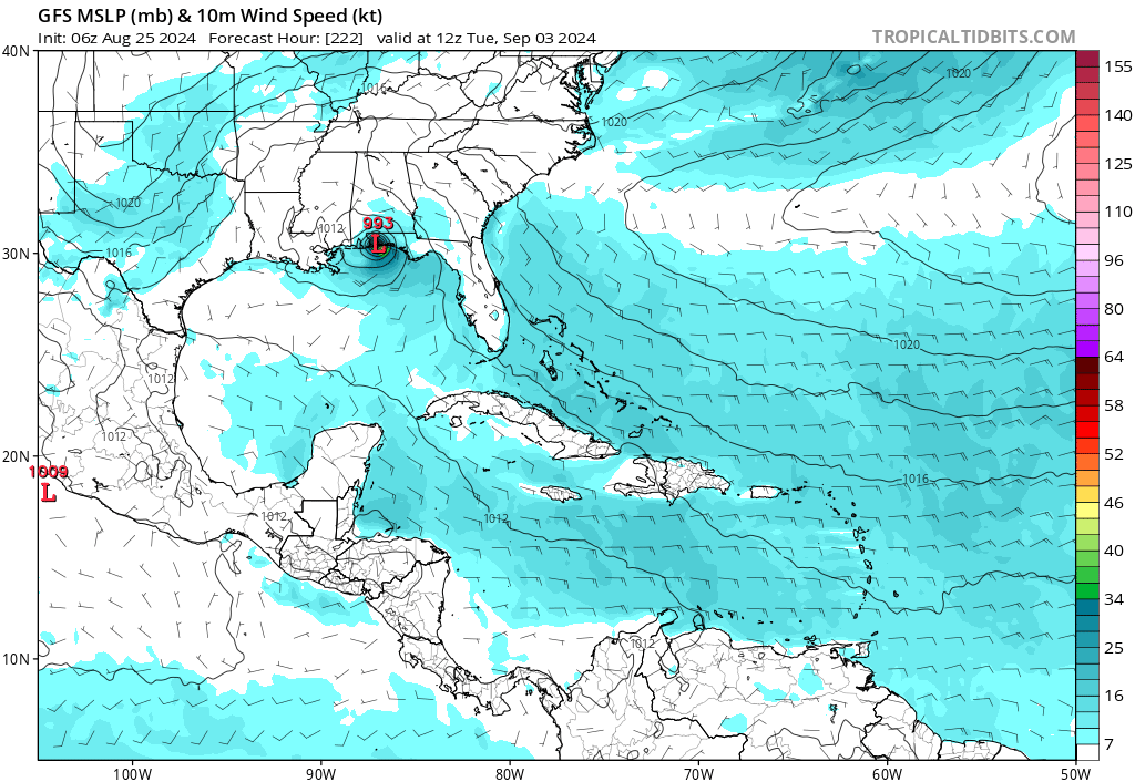
Re: 2024 Global Model Runs Discussion (Out thru day 16)
I mean, 6z GFS has this... But yeah, let's pretend it doesn't exist and there's absolutely nothing through 384 hrs.
1 likes
TC naming lists: retirements and intensity
Most aggressive Advisory #1's in North Atlantic (cr. kevin for starting the list)
Most aggressive Advisory #1's in North Atlantic (cr. kevin for starting the list)
-
txwxwatcher
- Tropical Storm
- Posts: 105
- Joined: Thu Feb 18, 2010 10:00 pm
Re: 2024 Global Model Runs Discussion (Out thru day 16)
cycloneye wrote:This is the grim look from GFS for September 10th that is peak season day. You would expect at least one or two areas of interest on the basin that date, but for now nothing. Let's see if GFS and other models change to more bullish in the next couple of weeks.
https://i.imgur.com/zJru6KE.png
Grim?? This looks beautiful to me and about 3 million or so of my fellow Houston residents. A map like that is glorious for us to see.
5 likes
-
DunedinDave
- Category 1

- Posts: 269
- Joined: Fri Aug 25, 2023 10:31 am
Re: 2024 Global Model Runs Discussion (Out thru day 16)
txwxwatcher wrote:cycloneye wrote:This is the grim look from GFS for September 10th that is peak season day. You would expect at least one or two areas of interest on the basin that date, but for now nothing. Let's see if GFS and other models change to more bullish in the next couple of weeks.
https://i.imgur.com/zJru6KE.png
Grim?? This looks beautiful to me and about 3 million or so of my fellow Houston residents. A map like that is glorious for us to see.
I agree. I know we have a lot of people I disagree with here but I’m good with a map showing no storms up through Sept 10. Our local meteorologist was talking about the season last night and said he was surprised at the lack of activity approaching peak day.
2 likes
Re: 2024 Global Model Runs Discussion (Out thru day 16)
Stormlover70 wrote:SAL is the inhibiting factor in my opinion. The climatology models have no analog for this.
100% agree even now you still see dry air some SAl 20N out to 55W and the absence of clouds/moisture in them.I for one am happy but not happy about the insurers soaking us in anticipation of activity.
https://www.tropicaltidbits.com/sat/sat ... =truecolor
0 likes
-
cajungal
- Category 5
- Posts: 2354
- Age: 49
- Joined: Sun Mar 14, 2004 9:34 pm
- Location: Schriever, Louisiana (60 miles southwest of New Orleans)
Re: 2024 Global Model Runs Discussion (Out thru day 16)
Experts are still expecting the dry air and SAL to diminish for September and they are predicting a back log and it to get busy again. But you think the models would be showing something by now. So we will see
0 likes
-
Hypercane_Kyle

- Category 5
- Posts: 3465
- Joined: Sat Mar 07, 2015 7:58 pm
- Location: Cape Canaveral, FL
Re: 2024 Global Model Runs Discussion (Out thru day 16)
Teban54 wrote:I mean, 6z GFS has this... But yeah, let's pretend it doesn't exist and there's absolutely nothing through 384 hrs.
https://i.postimg.cc/LXF67Lhb/gfs-mslp-wind-watl-38.png
One run, little ensemble support or support from any other models, and nearly 10 days out.
True it's more than nothing, but it's very close to it.
2 likes
My posts are my own personal opinion, defer to the National Hurricane Center (NHC) and other NOAA products for decision making during hurricane season.
Re: 2024 Global Model Runs Discussion (Out thru day 16)
Hypercane_Kyle wrote:Teban54 wrote:I mean, 6z GFS has this... But yeah, let's pretend it doesn't exist and there's absolutely nothing through 384 hrs.
https://i.postimg.cc/LXF67Lhb/gfs-mslp-wind-watl-38.png
One run, little ensemble support or support from any other models, and nearly 10 days out.
True it's more than nothing, but it's very close to it.
I agree with everything you said, but my main point was that it's especially misleading to post a 384 hr map with no development and say something along the lines of "not even a model storm out there", when the same run did show a model storm - just before 384 hrs.
Also, if people start being skeptical whenever a long-range model storm (Day 8 in this case) show up, why do people take runs with no development at face value, especially when they are in an even longer time frame (Day 16)?
4 likes
TC naming lists: retirements and intensity
Most aggressive Advisory #1's in North Atlantic (cr. kevin for starting the list)
Most aggressive Advisory #1's in North Atlantic (cr. kevin for starting the list)
-
Category5Kaiju
- Category 5
- Posts: 4330
- Joined: Thu Dec 24, 2020 12:45 pm
- Location: Seattle and Phoenix
Re: 2024 Global Model Runs Discussion (Out thru day 16)
Teban54 wrote:Hypercane_Kyle wrote:Teban54 wrote:I mean, 6z GFS has this... But yeah, let's pretend it doesn't exist and there's absolutely nothing through 384 hrs.
https://i.postimg.cc/LXF67Lhb/gfs-mslp-wind-watl-38.png
One run, little ensemble support or support from any other models, and nearly 10 days out.
True it's more than nothing, but it's very close to it.
I agree with everything you said, but my main point was that it's especially misleading to post a 384 hr map with no development and say something along the lines of "not even a model storm out there", when the same run did show a model storm - just before 384 hrs.
Also, if people start being skeptical whenever a long-range model storm (Day 8 in this case) show up, why do people take runs with no development at face value, especially when they are in an even longer time frame (Day 16)?
This is why I personally put more stock into ensembles than operational models. I mean, don't get me wrong, I do believe operational models have great use and have really helped tropical meteorology, but it seems like as of recently, ensembles have been better at sniffing out activity earlier than operationals have (Beryl and Debby come into mind), even if sometimes, the ensembles don't latch on coherently to a certain storm until mid-range.
0 likes
Unless explicitly stated, all info in my posts is based on my own opinions and observations. Tropical storms and hurricanes can be extremely dangerous. Refer to an accredited weather research agency or meteorologist if you need to make serious decisions regarding an approaching storm.
-
Hypercane_Kyle
- Category 5
- Posts: 3465
- Joined: Sat Mar 07, 2015 7:58 pm
- Location: Cape Canaveral, FL
Re: 2024 Global Model Runs Discussion (Out thru day 16)
Teban54 wrote:Hypercane_Kyle wrote:Teban54 wrote:I mean, 6z GFS has this... But yeah, let's pretend it doesn't exist and there's absolutely nothing through 384 hrs.
https://i.postimg.cc/LXF67Lhb/gfs-mslp-wind-watl-38.png
One run, little ensemble support or support from any other models, and nearly 10 days out.
True it's more than nothing, but it's very close to it.
I agree with everything you said, but my main point was that it's especially misleading to post a 384 hr map with no development and say something along the lines of "not even a model storm out there", when the same run did show a model storm - just before 384 hrs.
Also, if people start being skeptical whenever a long-range model storm (Day 8 in this case) show up, why do people take runs with no development at face value, especially when they are in an even longer time frame (Day 16)?
Consistency and across-the-board agreement is why. Exactly 1 run of the GFS has shown this solution in Day 8. There's been multi-model consensus for days now of it being absolutely dead in the Atlantic as the calendar flips into September over the next week. Inevitably, the 12z GFS will drop this system and we'll be back to the same background state. This is noteworthy, especially considering the strong signals for a hyperactive season.
0 likes
My posts are my own personal opinion, defer to the National Hurricane Center (NHC) and other NOAA products for decision making during hurricane season.
-
toad strangler

- S2K Supporter
- Posts: 4546
- Joined: Sun Jul 28, 2013 3:09 pm
- Location: Earth
- Contact:
Re: 2024 Global Model Runs Discussion (Out thru day 16)
Teban54 wrote:Hypercane_Kyle wrote:Teban54 wrote:I mean, 6z GFS has this... But yeah, let's pretend it doesn't exist and there's absolutely nothing through 384 hrs.
https://i.postimg.cc/LXF67Lhb/gfs-mslp-wind-watl-38.png
One run, little ensemble support or support from any other models, and nearly 10 days out.
True it's more than nothing, but it's very close to it.
I agree with everything you said, but my main point was that it's especially misleading to post a 384 hr map with no development and say something along the lines of "not even a model storm out there", when the same run did show a model storm - just before 384 hrs.
Also, if people start being skeptical whenever a long-range model storm (Day 8 in this case) show up, why do people take runs with no development at face value, especially when they are in an even longer time frame (Day 16)?
I think there will be plenty of egg on face to go around once December rolls around. It’s just too darn early. Regardless of preseason forecasts and current model runs. I know a place with amazing deal on fresh eggs
2 likes
My Weather Station
https://www.wunderground.com/dashboard/pws/KFLPORTS603
https://www.wunderground.com/dashboard/pws/KFLPORTS603
-
tolakram
- Admin
- Posts: 20178
- Age: 62
- Joined: Sun Aug 27, 2006 8:23 pm
- Location: Florence, KY (name is Mark)
Re: 2024 Global Model Runs Discussion (Out thru day 16)
toad strangler wrote:Teban54 wrote:Hypercane_Kyle wrote:
One run, little ensemble support or support from any other models, and nearly 10 days out.
True it's more than nothing, but it's very close to it.
I agree with everything you said, but my main point was that it's especially misleading to post a 384 hr map with no development and say something along the lines of "not even a model storm out there", when the same run did show a model storm - just before 384 hrs.
Also, if people start being skeptical whenever a long-range model storm (Day 8 in this case) show up, why do people take runs with no development at face value, especially when they are in an even longer time frame (Day 16)?
I think there will be plenty of egg on face to go around once December rolls around. It’s just too darn early. Regardless of preseason forecasts and current model runs. I know a place with amazing deal on fresh eggs
I'll disagree, but my response in the seasonal indicators thread.
1 likes
M a r k
- - - - -
Join us in chat: Storm2K Chatroom Invite. Android and IOS apps also available.
The posts in this forum are NOT official forecasts and should not be used as such. Posts are NOT endorsed by any professional institution or STORM2K.org. For official information and forecasts, please refer to NHC and NWS products.
-
DunedinDave
- Category 1
- Posts: 269
- Joined: Fri Aug 25, 2023 10:31 am
Re: 2024 Global Model Runs Discussion (Out thru day 16)
toad strangler wrote:Teban54 wrote:Hypercane_Kyle wrote:
One run, little ensemble support or support from any other models, and nearly 10 days out.
True it's more than nothing, but it's very close to it.
I agree with everything you said, but my main point was that it's especially misleading to post a 384 hr map with no development and say something along the lines of "not even a model storm out there", when the same run did show a model storm - just before 384 hrs.
Also, if people start being skeptical whenever a long-range model storm (Day 8 in this case) show up, why do people take runs with no development at face value, especially when they are in an even longer time frame (Day 16)?
I think there will be plenty of egg on face to go around once December rolls around. It’s just too darn early. Regardless of preseason forecasts and current model runs. I know a place with amazing deal on fresh eggs
Is it early? The peak is two weeks away and it looks like there’s a chance we could be heading into that with 0 storms. Once we get past Sept 10 we are on the slide down. Usually once Oct rolls around it dies down significantly.
We’ll see. But right now I’m cautiously optimistic of a quieter than expected season. Holding out hope because after Debby we can’t use anymore rain.
2 likes
-
Weathertracker96
- Tropical Storm
- Posts: 150
- Joined: Mon Oct 16, 2023 3:41 pm
Re: 2024 Global Model Runs Discussion (Out thru day 16)
Well the ICON looks to have a some activity on the 12z run.
Last edited by Weathertracker96 on Sun Aug 25, 2024 11:08 am, edited 1 time in total.
0 likes
Who is online
Users browsing this forum: NotSparta and 90 guests