2024 Indicators: SST's, MSLP, Shear, SAL, Steering, Instability (Day 16+ Climate Models)

This is the general tropical discussion area. Anyone can take their shot at predicting a storms path.

Moderator: S2k Moderators

Forum rules

The posts in this forum are NOT official forecasts and should not be used as such. They are just the opinion of the poster and may or may not be backed by sound meteorological data. They are NOT endorsed by any professional institution or STORM2K. For official information, please refer to products from the National Hurricane Center and National Weather Service.

Help Support Storm2K
Message
Author
User avatar
Category5Kaiju
Category 5
Category 5
Posts: 4051
Joined: Thu Dec 24, 2020 12:45 pm
Location: Seattle

Re: 2024 Indicators: SST's, MSLP, Shear, SAL, Steering, Instability (Day 16+ Climate Models)

#2181 Postby Category5Kaiju » Mon Aug 26, 2024 8:06 am

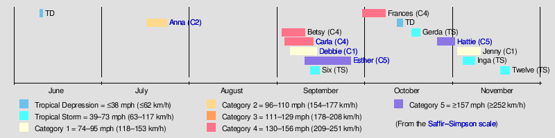
toad strangler wrote:Credit: Michael Lowry 8/26/2024

Another Strangely Stormless Week Expected Across the Atlantic. If forecasts verify, two of the traditionally busier weeks of hurricane season will pass without a single active Atlantic system, a first in nearly 70 years

We don’t want to be the ones to tempt fate, or to jinx a good thing, but forecast models continue to advertise another strangely stormless week in the Atlantic, which could get us into early September without another tropical system.

If the 7-day outlook from the National Hurricane Center materializes, this means we’ll have gone two weeks – from the demise of Ernesto on August 20th – without an active tropical or subtropical system anywhere in the Atlantic, the first time that’s happened during this traditionally busy two-week window of the hurricane season since 1956.

That’s not exactly what we would’ve anticipated for late August and in the opening days of September during one of the most active hurricane seasons ever forecast. Of course, we know better than to look a gift horse in the mouth, especially when history shows us 80% of tropical activity occurs after August 26th. It’s kind of like declaring victory in the 2nd inning of a 9-inning baseball game or 12 minutes into the first quarter of a 60-minute football game.

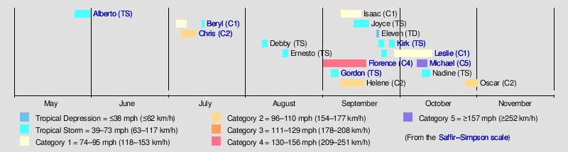
It’s also not like the opposing team hasn’t already put up some impressive points. As we discussed last Monday, we’ve recorded more than double the average activity we typically see through this point in the season, including the earliest Category 5 hurricane on record and two U.S. hurricane landfalls. To taunt this season right now would be foolish – a little like ridiculing a first seed that still carries a healthy lead after a bad quarter.

But it’s also fair to say that if the models are right and the Atlantic is a no-show for another 7, 8, or 9 days, that’d be pretty weird, not despite the blistering start, but because of it. Hurricane Beryl which became a 165 mph Category 5 monster earlier this season wasn’t just a early-season curiosity, it was an extreme anomaly, something that could only have happened in a year where the Atlantic was so tilted for development, it made the end of June resemble late August or September. Beryls don’t happen in normal hurricane seasons before August.

This time of year, we take the forecasts day-by-day and with a grain of salt. Computer models are notoriously poor at predicting tropical formation more than just a few days out. It’s unusual we don’t see more candidates for possible development in most of our ensemble members – the scenarios we look at based on dozens of different starting conditions to account for the possibility of larger uncertainty farther out in the forecast. But there may be good reason for the lull. We’ve described ad nauseum the short-term issues plaguing the Atlantic right now, which we discussed last week will take at least another week to shake out.


People currently doubting the season just *might* want to refer to the global model discussion for further info. In short: things seem to be changing. :lol:
3 likes   
Unless explicitly stated, all info in my posts is based on my own opinions and observations. Tropical storms and hurricanes can be extremely dangerous. Do not think you can beat Mother Nature. Refer to an accredited weather research agency or meteorologist if you need to make serious decisions regarding an approaching storm.

LarryWx
Category 5
Category 5
Posts: 6246
Joined: Sun Sep 07, 2003 2:04 pm
Location: GA

Re: 2024 Indicators: SST's, MSLP, Shear, SAL, Steering, Instability (Day 16+ Climate Models)

#2182 Postby LarryWx » Mon Aug 26, 2024 8:36 am

Based on the various recent ensembles, including the 6Z GEFS:

1. I’m leaning toward unfortunately not getting that full 2 weeks of quiet referred to in the Toad Strangler/Michael Lowry post that is two posts above this. It may end up being closer to 10-11 days.

2. I’m expecting that today’s Euro Weeklies mean will for the first time in quite awhile increase the projected ACE for 9/2-8.
Edit: I’m also leaning toward the subsequent week, 9/9-15, also rising vs yesterday due to this same potential TC possibly going into early that week, too, due to potential fairly slow movement.
Last edited by LarryWx on Mon Aug 26, 2024 8:49 am, edited 2 times in total.
3 likes   
Personal Forecast Disclaimer:
The posts in this forum are NOT official forecasts and should not be used as such. They are just the opinion of the poster and may or may not be backed by sound meteorological data. They are NOT endorsed by any professional institution or storm2k.org. For official information, please refer to the NHC and NWS products.

tolakram
Admin
Admin
Posts: 19990
Age: 61
Joined: Sun Aug 27, 2006 8:23 pm
Location: Florence, KY (name is Mark)

Re: 2024 Indicators: SST's, MSLP, Shear, SAL, Steering, Instability (Day 16+ Climate Models)

#2183 Postby tolakram » Mon Aug 26, 2024 8:42 am

I think it's likely we have something on Labor Day, even though it's early this year. There's a difference between not hitting the numbers and a bad season. Yea, I used 2013 in my Labor Day example, but hopefully no one expects 2013 to happen again. The point was to show that big number seasons can't have slow to normal peaks.
2 likes   
M a r k
- - - - -
Join us in chat: Storm2K Chatroom Invite. Android and IOS apps also available.

The posts in this forum are NOT official forecasts and should not be used as such. Posts are NOT endorsed by any professional institution or STORM2K.org. For official information and forecasts, please refer to NHC and NWS products.

User avatar
Teban54
Category 5
Category 5
Posts: 3168
Joined: Sat May 19, 2018 1:19 pm

Re: 2024 Indicators: SST's, MSLP, Shear, SAL, Steering, Instability (Day 16+ Climate Models)

#2184 Postby Teban54 » Mon Aug 26, 2024 12:29 pm

Official data on the position of the Intertropical Front (ITF) for August 11-20 is now available. To recall, this chart for August 1-10 generated a lot of discussions about the ITCZ being too far north.

While the eastern ITF is still further north than climo, it has shifted south compared to August 1-10 and has become less anomalous. The western ITF (average of 10W to 10E) has become a bit more anomalously north, though. Still, it seems like a more favorable configuration to me overall, though I'm no expert on this.

Image

Image

Image
1 likes   

User avatar
WaveBreaking
Category 2
Category 2
Posts: 562
Joined: Sun Jun 30, 2024 11:33 am
Location: US

Re: 2024 Indicators: SST's, MSLP, Shear, SAL, Steering, Instability (Day 16+ Climate Models)

#2185 Postby WaveBreaking » Mon Aug 26, 2024 1:27 pm

Overall mid-level dry air has decreased in the past few days, and it will probably decrease even more once that SAL outbreak passes by.

Image
1 likes   
I am NOT a professional meteorologist, so take all of my posts with a grain of salt. My opinions are mine and mine alone.

LarryWx
Category 5
Category 5
Posts: 6246
Joined: Sun Sep 07, 2003 2:04 pm
Location: GA

Re: 2024 Indicators: SST's, MSLP, Shear, SAL, Steering, Instability (Day 16+ Climate Models)

#2186 Postby LarryWx » Mon Aug 26, 2024 3:15 pm

LarryWx wrote:Based on the various recent ensembles, including the 6Z GEFS:

1. I’m leaning toward unfortunately not getting that full 2 weeks of quiet referred to in the Toad Strangler/Michael Lowry post that is two posts above this. It may end up being closer to 10-11 days.

2. I’m expecting that today’s Euro Weeklies mean will for the first time in quite awhile increase the projected ACE for 9/2-8.
Edit: I’m also leaning toward the subsequent week, 9/9-15, also rising vs yesterday due to this same potential TC possibly going into early that week, too, due to potential fairly slow movement.


Surprisingly to me, today’s Euro Weeklies had no uptick in the mean ACE progs. These are based on today’s 0Z extended EPS. Had they been based on today’s 12Z instead, I’m confident there would have been an uptick. They stayed the same for weeks 1-3 and had a slight down tick for week 4.

Regardless, the maps showing the areas with enhanced chances of TC strike suggest for weeks 3-4 (9/9-22) the highest chance in and near the SE US for any run since I started following these daily. Also, week 3 has the highest chance of any run for the corridor SE to PR.
0 likes   
Personal Forecast Disclaimer:
The posts in this forum are NOT official forecasts and should not be used as such. They are just the opinion of the poster and may or may not be backed by sound meteorological data. They are NOT endorsed by any professional institution or storm2k.org. For official information, please refer to the NHC and NWS products.

tolakram
Admin
Admin
Posts: 19990
Age: 61
Joined: Sun Aug 27, 2006 8:23 pm
Location: Florence, KY (name is Mark)

Re: 2024 Indicators: SST's, MSLP, Shear, SAL, Steering, Instability (Day 16+ Climate Models)

#2187 Postby tolakram » Mon Aug 26, 2024 6:23 pm

How is this season similar to 2017 (from the global thread)?

Image
0 likes   
M a r k
- - - - -
Join us in chat: Storm2K Chatroom Invite. Android and IOS apps also available.

The posts in this forum are NOT official forecasts and should not be used as such. Posts are NOT endorsed by any professional institution or STORM2K.org. For official information and forecasts, please refer to NHC and NWS products.

User avatar
weeniepatrol
Category 5
Category 5
Posts: 1252
Joined: Sat Aug 22, 2020 5:30 pm
Location: WA State

Re: 2024 Indicators: SST's, MSLP, Shear, SAL, Steering, Instability (Day 16+ Climate Models)

#2188 Postby weeniepatrol » Mon Aug 26, 2024 6:31 pm

Yeah. So. I know it's been a weird week, but we do realize 200 ACE is still easily reachable, yes? Now, I do think 20+ storms is unlikely.

For example, consider the following years:

1998

Image

1999

Image


The "F" storm didn't form until 8 September, and 7 September, respectively.

Image

ACE is much higher than it was on this date in those years. Both were 175+ ACE hyperactive seasons
3 likes   

LarryWx
Category 5
Category 5
Posts: 6246
Joined: Sun Sep 07, 2003 2:04 pm
Location: GA

Re: 2024 Indicators: SST's, MSLP, Shear, SAL, Steering, Instability (Day 16+ Climate Models)

#2189 Postby LarryWx » Mon Aug 26, 2024 6:42 pm

weeniepatrol wrote:Yeah. So. I know it's been a weird week, but we do realize 200 ACE is still easily reachable, yes? Now, I do think 20+ storms is unlikely.

For example, consider the following years:

1998

https://i.imgur.com/wQ88NPy.png

1999

https://i.imgur.com/3rRKt6J.png


The "F" storm didn't form until 8 September, and 7 September, respectively.

https://i.imgur.com/dlF25XZ.png

ACE is much higher than it was on this date in those years. Both were 175+ ACE hyperactive seasons


The record high # of documented NS back to 1851 forming Sep 1+ is 16. This implies to me a reasonable ceiling for this season of ~21 total.
2 likes   
Personal Forecast Disclaimer:
The posts in this forum are NOT official forecasts and should not be used as such. They are just the opinion of the poster and may or may not be backed by sound meteorological data. They are NOT endorsed by any professional institution or storm2k.org. For official information, please refer to the NHC and NWS products.

User avatar
weeniepatrol
Category 5
Category 5
Posts: 1252
Joined: Sat Aug 22, 2020 5:30 pm
Location: WA State

Re: 2024 Indicators: SST's, MSLP, Shear, SAL, Steering, Instability (Day 16+ Climate Models)

#2190 Postby weeniepatrol » Mon Aug 26, 2024 6:52 pm

LarryWx wrote: The record high # of documented NS back to 1851 forming Sep 1+ is 16. This implies to me a reasonable ceiling for this season of ~21 total.


That's... insane. 2020 I presume? Gotta be.

Would require a substantial change in how activity is occurring. This season, we haven't even had a single hint at a subtropical spinup. Not sure this would suddenly change, and it would certainly have to for us to get our numbers padded by that much.
1 likes   

User avatar
Teban54
Category 5
Category 5
Posts: 3168
Joined: Sat May 19, 2018 1:19 pm

Re: 2024 Indicators: SST's, MSLP, Shear, SAL, Steering, Instability (Day 16+ Climate Models)

#2191 Postby Teban54 » Mon Aug 26, 2024 7:04 pm

weeniepatrol wrote:
LarryWx wrote: The record high # of documented NS back to 1851 forming Sep 1+ is 16. This implies to me a reasonable ceiling for this season of ~21 total.


That's... insane. 2020 I presume? Gotta be.

Would require a substantial change in how activity is occurring. This season, we haven't even had a single hint at a subtropical spinup. Not sure this would suddenly change, and it would certainly have to for us to get our numbers padded by that much.

The record of 16 storms since September 1 is a two-way tie between 2005 and 2020. (Technically, depending on whether you're using UTC vs. local time and TD formation vs. TS classification, you can argue 2020 had 17 storms if Omar is counted.)

Note that 2005 and 2020 took slightly different approaches to reach there.
  • 2005's storm counts each month from September onwards were 5/7/3/1. October almost got close to the all-time October NS record of 8, whereas September was slightly more quality-over-quantity with all 5 storms becoming hurricanes (three Cat 1s, one Cat 3, and Rita).
  • 2020's storm counts were 9/4/3/0 (or 10/4/3/0 with Omar). September was the spammy month that set the record for the highest number of monthly formations, whereas October didn't have insane storm counts but did have insane quality (that continued into November).
3 likes   

User avatar
chaser1
S2K Supporter
S2K Supporter
Posts: 5407
Age: 64
Joined: Sat Oct 15, 2005 5:59 pm
Location: Longwood, Fl

Re: 2024 Indicators: SST's, MSLP, Shear, SAL, Steering, Instability (Day 16+ Climate Models)

#2192 Postby chaser1 » Mon Aug 26, 2024 7:08 pm

Imagine this season ending as:
15/11/6, but with 4 majors hitting the Greater Antilles & U.S. and one more striking Central America. "Bust year"?
2 likes   
Andy D

(For official information, please refer to the NHC and NWS products.)

User avatar
aspen
Category 5
Category 5
Posts: 8812
Joined: Sat Oct 12, 2019 7:10 pm
Location: Connecticut, USA

Re: 2024 Indicators: SST's, MSLP, Shear, SAL, Steering, Instability (Day 16+ Climate Models)

#2193 Postby aspen » Mon Aug 26, 2024 7:21 pm

chaser1 wrote:Imagine this season ending as:
15/11/6, but with 4 majors hitting the Greater Antilles & U.S. and one more striking Central America. "Bust year"?

Not impossible. If you’re looking only at named storms, it’d be the biggest bust year relative to seasonal outlooks. Definitely not a bust when it comes to quality of storms, though.
0 likes   
Irene '11 Sandy '12 Hermine '16 5/15/2018 Derecho Fay '20 Isaias '20 Elsa '21 Henri '21 Ida '21

I am only a meteorology enthusiast who knows a decent amount about tropical cyclones. Look to the professional mets, the NHC, or your local weather office for the best information.

User avatar
Category5Kaiju
Category 5
Category 5
Posts: 4051
Joined: Thu Dec 24, 2020 12:45 pm
Location: Seattle

Re: 2024 Indicators: SST's, MSLP, Shear, SAL, Steering, Instability (Day 16+ Climate Models)

#2194 Postby Category5Kaiju » Mon Aug 26, 2024 7:27 pm

aspen wrote:
chaser1 wrote:Imagine this season ending as:
15/11/6, but with 4 majors hitting the Greater Antilles & U.S. and one more striking Central America. "Bust year"?

Not impossible. If you’re looking only at named storms, it’d be the biggest bust year relative to seasonal outlooks. Definitely not a bust when it comes to quality of storms, though.


Ngl, even during the very start of the season, I thought that 20-25 NSs was possible. I had reservations about the 33 or something like that NSs prediction as it simply seemed waayyy too insane to even fathom, but I think it's becoming clearer by the day that there may indeed be an inverse correlation between quantity and quality in the Atlantic.
1 likes   
Unless explicitly stated, all info in my posts is based on my own opinions and observations. Tropical storms and hurricanes can be extremely dangerous. Do not think you can beat Mother Nature. Refer to an accredited weather research agency or meteorologist if you need to make serious decisions regarding an approaching storm.

User avatar
Teban54
Category 5
Category 5
Posts: 3168
Joined: Sat May 19, 2018 1:19 pm

Re: 2024 Indicators: SST's, MSLP, Shear, SAL, Steering, Instability (Day 16+ Climate Models)

#2195 Postby Teban54 » Mon Aug 26, 2024 7:32 pm

Continuing from the Global Model Runs thread:
skyline385 wrote:
Teban54 wrote:
Hypercane_Kyle wrote:
All major points regarding this season's now very obvious handicap do not become invalid because of one storm at the peak of the season.

The problem is that folks over-emphasize any negative factor(s) simply because of no storms through a 15-day period.

I have made this point several times, but I maintain this: 2024's seasonal timeline still closely resembles 2017-without Harvey. (Yes, I know you can't arbitrarily exclude storms, but then there's Beryl too.) Irma "only" formed on August 30, and all other MDR storms until then were weak and struggling. But apparently, now that we're looking at 2017 in hindsight, nobody talks about some apocalyptic inhibiting factor that made the deep tropics of 2017 so unfavorable that it couldn't generate more than 5 ACE until YTD.


On the topic of "folks over-emphasize any negative factor(s)", people also do it the other way. Any discussion regarding inhibiting factors is immediately called as season bustcasting even if experts themselves are having a discussion on it. It would definitely be much better if people wouldnt be jumping between the two extremes so that nuanced discussions in between can be had.

Since around August 20, and especially over the past weekend, I don't recall seeing anyone immediately accusing others of season canceling (and if someone did so, they were called out). Instead, there have been a lot of "nuanced discussions" during this period just as you said. Prior to that, yes, some of that happened, but that was also historically a premature time to cast doubts on peak season activity (as almost every year other than 2013, and 2022 somewhat, has shown).

skyline385 wrote:Also bear in Irma formed much further east than models are showing for this system which should be somewhere in early September. Irma was an anomaly so I would hold on before making the comparisons to 2017.

tolakram wrote:How is this season similar to 2017 (from the global thread)?

Image

To clarify my point about 2017 once and for all:

First of all, I'm specifically talking about the season timeline, in terms of the general pattern of storms and ACE. I'd also like to clarify that I focused less on weak TSes, since your standard June Gulf CAG or East Coast spin-up has little predictive power on seasonal activity.

The one similarity that drew me to 2017, as early as half a month ago, was early August activity. Both 2017 and 2024 had a brief Cat 1 with a Gulf landfall, and then a recurving Cat 2 in the subtropics. I'm not saying the very specific details of intensity and track mean anything, but they're at least quite eerie -- and way more importantly, the first half of August in both years were basically tied as the most active since at least 2012 or so. Before that, both years also had early-season MDR activities that were each record-breaking in their own ways.

The obvious difference is Harvey. That does mean 2017's western parts of the basin were more favorable than 2024... But two caveats exist. (1) 2024 had Beryl, and thus, still has higher ACE than 2017 YTD. (2) More importantly, 2017's tropics remained hostile until this date. TUTTs sheared apart Harvey Part 1 and PTC 10 as they traversed across the tropical Atlantic, making the models a huge bust as they were hyping up both systems to be MDR majors. People were quick to point out dry air in the MDR that lasted until Irma formed. So, despite Harvey, it would be totally natural at that time to say "a Cat 4 in the Gulf doesn't eliminate the very obvious handicap in the MDR" -- and that's exactly what people did. In fact, by August 26, 2017, most people were expecting a west-based season, similar to 2005's general distribution of storms.

My key point is: 2017 had a historically active September in a region that many inhibiting factors existed until August 30. Today, people no longer talk about factors inhibiting 2017's August MDR activity, even if they could have been "very obvious" at that time. If those factors can stop adversely affecting the season after Irma, then maybe, just maybe, the same can happen to 2024, but on a broader scale that's not limited to just the MDR?

In case it remains unclear by now: Yes, I acknowledge that Irma is a much more anomalous storm than the currently modeled Francine will likely be (which has not even formed yet). But I wasn't predicting that Francine will resemble Irma in any way, or that September 2024 will have as much ACE as September 2017, etc. The point was that Irma was a true turning point in people's perspective of the 2017 season that even Harvey wasn't. And while the story of September 2024 and even Francine itself is yet to be written (meaning it can theoretically be just a freak storm in an otherwise quiet month), it's entirely possible -- and my gut feeling is that it will happen -- that Francine will be a turning point in how people talk about the season and its indicators.

Finally, you don't need to rely on 2017 to find seasons that were active in September and beyond after having dead Augusts (late Augusts included). Weeniepatrol already posted 1998 and 1999 above, but in case you were bothered by how they both had late August majors, I'll present to you 1961. This season did not even have its B storm on September 1, yet finished with 189 ACE, the 9th highest on record. (Betsy 1961 is also much more in line with the expected Francine 2024 and the climo than Irma is.)

Image

Or, for a more modest example, here's 2018. Florence formed on August 31, after only having Debby and Ernesto (deja vu, huh?) as weak TS in the subtropics in August. This was an El Nino year; 2024 will not be.

Image
3 likes   

User avatar
Ubuntwo
Category 5
Category 5
Posts: 1401
Age: 31
Joined: Thu Oct 05, 2017 10:41 pm

Re: 2024 Indicators: SST's, MSLP, Shear, SAL, Steering, Instability (Day 16+ Climate Models)

#2196 Postby Ubuntwo » Mon Aug 26, 2024 7:33 pm

Category5Kaiju wrote:
aspen wrote:
chaser1 wrote:Imagine this season ending as:
15/11/6, but with 4 majors hitting the Greater Antilles & U.S. and one more striking Central America. "Bust year"?

Not impossible. If you’re looking only at named storms, it’d be the biggest bust year relative to seasonal outlooks. Definitely not a bust when it comes to quality of storms, though.


Ngl, even during the very start of the season, I thought that 20-25 NSs was possible. I had reservations about the 33 or something like that NSs prediction as it simply seemed waayyy too insane to even fathom, but I think it's becoming clearer by the day that there may indeed be an inverse correlation between quantity and quality in the Atlantic.

I disagree with the latter statement. 2020 and 2005 are both tied #1 in terms of overall TC count and major hurricane count. There have definitely been 'quality' seasons like 2004 and 'quantity' seasons like 2021, but these were both near average (if not above) in their relatively weaker factors.
1 likes   
Kendall -> SLO -> PBC

Memorable Storms: Katrina (for its Florida landfall...) Wilma Matthew Irma

User avatar
Category5Kaiju
Category 5
Category 5
Posts: 4051
Joined: Thu Dec 24, 2020 12:45 pm
Location: Seattle

Re: 2024 Indicators: SST's, MSLP, Shear, SAL, Steering, Instability (Day 16+ Climate Models)

#2197 Postby Category5Kaiju » Mon Aug 26, 2024 7:44 pm

Ubuntwo wrote:
Category5Kaiju wrote:
aspen wrote:Not impossible. If you’re looking only at named storms, it’d be the biggest bust year relative to seasonal outlooks. Definitely not a bust when it comes to quality of storms, though.


Ngl, even during the very start of the season, I thought that 20-25 NSs was possible. I had reservations about the 33 or something like that NSs prediction as it simply seemed waayyy too insane to even fathom, but I think it's becoming clearer by the day that there may indeed be an inverse correlation between quantity and quality in the Atlantic.

I disagree with the latter statement. 2020 and 2005 are both tied #1 in terms of overall TC count and major hurricane count. There have definitely been 'quality' seasons like 2004 and 'quantity' seasons like 2021, but these were both near average (if not above) in their relatively weaker factors.


Sorry, I think I made a mistake in not clarifying my previous statement. I meant primarily in the context of long-tracking major hurricanes, predominantly born near the Cape Verde Islands. I could be totally wrong in the near future, but, for instance, we've never seen a hurricane season with 25+ NSs and many individual high-ACE systems. I think that partially may be because such systems create such incredible outflow that it would shear anything nearby to death, thereby limiting the bulk number of systems that are able to really form.
2 likes   
Unless explicitly stated, all info in my posts is based on my own opinions and observations. Tropical storms and hurricanes can be extremely dangerous. Do not think you can beat Mother Nature. Refer to an accredited weather research agency or meteorologist if you need to make serious decisions regarding an approaching storm.

LarryWx
Category 5
Category 5
Posts: 6246
Joined: Sun Sep 07, 2003 2:04 pm
Location: GA

Re: 2024 Indicators: SST's, MSLP, Shear, SAL, Steering, Instability (Day 16+ Climate Models)

#2198 Postby LarryWx » Mon Aug 26, 2024 7:58 pm

“One of the theories for why August was some quiet in the NATL lies in the Mid-Latitudes. A very potent +NAO shifted eastward has been present across the North Atlantic for much of August. As a result of this we've seen stable air being sent equatorward in large quantities:”

https://twitter.com/WxPatel/status/1828231491018436866?
3 likes   
Personal Forecast Disclaimer:
The posts in this forum are NOT official forecasts and should not be used as such. They are just the opinion of the poster and may or may not be backed by sound meteorological data. They are NOT endorsed by any professional institution or storm2k.org. For official information, please refer to the NHC and NWS products.

User avatar
CyclonicFury
Category 5
Category 5
Posts: 2019
Age: 26
Joined: Sun Jul 02, 2017 12:32 pm
Location: NC
Contact:

Re: 2024 Indicators: SST's, MSLP, Shear, SAL, Steering, Instability (Day 16+ Climate Models)

#2199 Postby CyclonicFury » Mon Aug 26, 2024 9:47 pm

It appears that the unusual late August lull over the NATL will likely be ending soon. The 0/20 AOI has a very solid signal for development across both the GEFS and EPS suites, and the ECMWF/EPS are showing 2 more vigorous AEWs over the next 10 days. I think the lid is about to come off, and there's a chance we could have 2-3 MDR TCs over the coming 10 day period.
3 likes   
NCSU B.S. in Meteorology Class of 2021. Tropical weather blogger at http://www.cyclonicfury.com. My forecasts and thoughts are NOT official, for official forecasts please consult the National Hurricane Center.

User avatar
kevin
Category 5
Category 5
Posts: 2554
Age: 26
Joined: Wed Aug 28, 2019 4:35 am

Re: 2024 Indicators: SST's, MSLP, Shear, SAL, Steering, Instability (Day 16+ Climate Models)

#2200 Postby kevin » Tue Aug 27, 2024 6:52 am

As it looks like we're getting out of the August lull, MPI is ready to go with most of the tropical Atlantic now being cat 5 ready. Most of the WCar/Gulf also has an MPI below 900 mb. Shear across almost the entirety of the MDR is also favorable. There are of course other factors at play as well (otherwise we wouldn't have had the lack of activity so far), but shear and MPI seem to favor development right now.

Image

Image
2 likes   


Return to “Talkin' Tropics”

Who is online

Users browsing this forum: No registered users and 212 guests