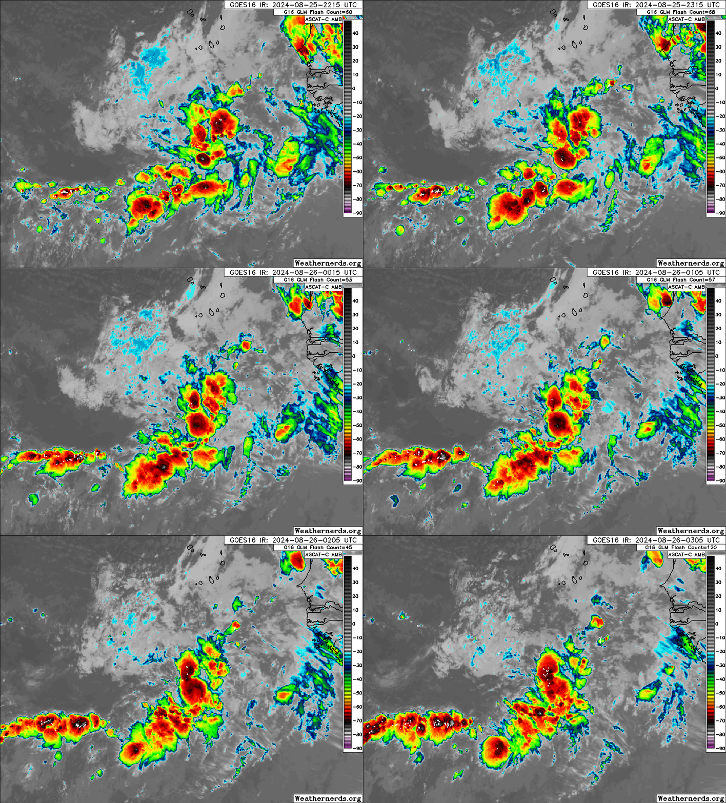
Tropical Wave in Bay of Campeche (Is Invest 91L)

This is the general tropical discussion area. Anyone can take their shot at predicting a storms path.

Moderator: S2k Moderators

Forum rules

The posts in this forum are NOT official forecasts and should not be used as such. They are just the opinion of the poster and may or may not be backed by sound meteorological data. They are NOT endorsed by any professional institution or STORM2K. For official information, please refer to products from the National Hurricane Center and National Weather Service.

Help Support Storm2K
Message
Author
MarioProtVI
Category 4
Category 4
Posts: 932
Age: 23
Joined: Sun Sep 29, 2019 7:33 pm
Location: New Jersey

Tropical Wave in Bay of Campeche (Is Invest 91L)

#1 Postby MarioProtVI » Sun Aug 25, 2024 7:18 pm

Image

Kinda decent looking IMO. Not sure if this is the wave the ensembles and some models seem to like or not, but definitely better then the previous waves. Need to watch it though maybe.
8 likes   

User avatar
Teban54
Category 5
Category 5
Posts: 3168
Joined: Sat May 19, 2018 1:19 pm

Re: Tropical wave near Cabo Verde

#2 Postby Teban54 » Sun Aug 25, 2024 10:21 pm

The wave definitely seems to be holding its convection together pretty well, more so than the model runs and "dry Atlantic" calls would make you think. Whether it outperforms the models remain a question, however.

Image
5 likes   

LarryWx
Category 5
Category 5
Posts: 6246
Joined: Sun Sep 07, 2003 2:04 pm
Location: GA

Re: Tropical wave near Cabo Verde

#3 Postby LarryWx » Sun Aug 25, 2024 10:53 pm

I believe that this is the disturbance that the ICON and 20+ Euro-AIFS runs in a row were developing near the start of Sep (in about 5-8 days) as it approached the Leewards.
1 likes   
Personal Forecast Disclaimer:
The posts in this forum are NOT official forecasts and should not be used as such. They are just the opinion of the poster and may or may not be backed by sound meteorological data. They are NOT endorsed by any professional institution or storm2k.org. For official information, please refer to the NHC and NWS products.

User avatar
Teban54
Category 5
Category 5
Posts: 3168
Joined: Sat May 19, 2018 1:19 pm

Re: Tropical wave near Cabo Verde

#4 Postby Teban54 » Sun Aug 25, 2024 10:57 pm

LarryWx wrote:I believe that this is the disturbance that the ICON and 20+ Euro-AIFS runs in a row were developing near the start of Sep (in about 5-8 days) as it approached the Leewards.

ICON still develops either this wave or one to the west:

Image
4 likes   

User avatar
WaveBreaking
Category 2
Category 2
Posts: 562
Joined: Sun Jun 30, 2024 11:33 am
Location: US

Re: Tropical wave near Cabo Verde

#5 Postby WaveBreaking » Mon Aug 26, 2024 6:55 am

NHC will probably put a lemon on this in the next couple of days. IMO it should be a 0/10 or a 0/20 since it has decent ensemble support.
0 likes   
I am NOT a professional meteorologist, so take all of my posts with a grain of salt. My opinions are mine and mine alone.

User avatar
WaveBreaking
Category 2
Category 2
Posts: 562
Joined: Sun Jun 30, 2024 11:33 am
Location: US

Re: Tropical wave near Cabo Verde

#6 Postby WaveBreaking » Mon Aug 26, 2024 10:52 am

Still looks good on ASCAT

Image


Wave axis is almost W-E. Need northerlies on the west side for a closed circulation.

Image
0 likes   

I am NOT a professional meteorologist, so take all of my posts with a grain of salt. My opinions are mine and mine alone.

User avatar
Hurricaneman
Category 5
Category 5
Posts: 7349
Age: 44
Joined: Tue Aug 31, 2004 3:24 pm
Location: central florida

Re: Tropical wave near Cabo Verde

#7 Postby Hurricaneman » Mon Aug 26, 2024 2:44 pm

The GEFS, EPS and op Euro seem to want to develop this feature sometime later this week into the weekend and a lot of those GFS and Euro ensembles are showing a substantial system from this in the western part of the basin as we go into September so this might be one to really watch as we go forward

By the way the 12zEuro shows a TS from this near Puerto Rico at the end of the run
2 likes   

User avatar
Nimbus
Category 5
Category 5
Posts: 5274
Joined: Mon Jul 19, 2004 10:54 am

Re: Tropical wave near Cabo Verde

#8 Postby Nimbus » Mon Aug 26, 2024 3:48 pm

Hurricaneman wrote:The GEFS, EPS and op Euro seem to want to develop this feature sometime later this week into the weekend and a lot of those GFS and Euro ensembles are showing a substantial system from this in the western part of the basin as we go into September so this might be one to really watch as we go forward

By the way the 12zEuro shows a TS from this near Puerto Rico at the end of the run


Going to be a long thread.
12Z Icon tracks this north of Puerto Rico 12Z euro south through the Caribbean.
2 likes   

User avatar
cycloneye
Admin
Admin
Posts: 143862
Age: 68
Joined: Thu Oct 10, 2002 10:54 am
Location: San Juan, Puerto Rico

Re: Tropical wave near Cabo Verde

#9 Postby cycloneye » Mon Aug 26, 2024 3:57 pm

Nimbus wrote:
Hurricaneman wrote:The GEFS, EPS and op Euro seem to want to develop this feature sometime later this week into the weekend and a lot of those GFS and Euro ensembles are showing a substantial system from this in the western part of the basin as we go into September so this might be one to really watch as we go forward

By the way the 12zEuro shows a TS from this near Puerto Rico at the end of the run


Going to be a long thread.
12Z Icon tracks this north of Puerto Rico 12Z euro south through the Caribbean.


Well, if or when it is a invest, this thread will close and the invest one will be the long one.
5 likes   
Visit the Caribbean-Central America Weather Thread where you can find at first post web cams,radars
and observations from Caribbean basin members Click Here

climateconcernnew
Tropical Low
Tropical Low
Posts: 10
Joined: Fri Sep 14, 2018 9:19 am

Re: Tropical wave near Cabo Verde

#10 Postby climateconcernnew » Mon Aug 26, 2024 5:40 pm

As per 18z GFS, in 190+ hrs it attains a mere depression around Lesser Antilles.
0 likes   
These are only my personal views or opinions. They are not verified and may cause danger. For your reference please seek official forecast.

underthwx
Category 5
Category 5
Posts: 2351
Joined: Sat Jul 30, 2011 2:14 pm
Location: Brazoria County Texas

Re: Tropical wave near Cabo Verde

#11 Postby underthwx » Mon Aug 26, 2024 6:14 pm

cycloneye wrote:
Nimbus wrote:
Hurricaneman wrote:The GEFS, EPS and op Euro seem to want to develop this feature sometime later this week into the weekend and a lot of those GFS and Euro ensembles are showing a substantial system from this in the western part of the basin as we go into September so this might be one to really watch as we go forward

By the way the 12zEuro shows a TS from this near Puerto Rico at the end of the run


Going to be a long thread.
12Z Icon tracks this north of Puerto Rico 12Z euro south through the Caribbean.


Well, if or when it is a invest, this thread will close and the invest one will be the long one.

True that CE.....do you feel this wave has potential to develop?...
0 likes   

MarioProtVI
Category 4
Category 4
Posts: 932
Age: 23
Joined: Sun Sep 29, 2019 7:33 pm
Location: New Jersey

Tropical wave near Cabo Verde (0/20)

#12 Postby MarioProtVI » Mon Aug 26, 2024 6:39 pm

Tropical Weather Outlook
NWS National Hurricane Center Miami FL
800 PM EDT Mon Aug 26 2024

For the North Atlantic...Caribbean Sea and the Gulf of Mexico:

Central Tropical Atlantic:
An area of low pressure could form in the central portion of the
Tropical Atlantic in a few days. Thereafter, environmental
conditions appear generally favorable for some slow development of
this system by this weekend into early next week as it moves
westward to west-northwestward at 10 to 15 mph.
* Formation chance through 48 hours...low...near 0 percent.
* Formation chance through 7 days...low...20 percent.
6 likes   

User avatar
weeniepatrol
Category 5
Category 5
Posts: 1252
Joined: Sat Aug 22, 2020 5:30 pm
Location: WA State

Re: Tropical wave near Cabo Verde (0/20)

#13 Postby weeniepatrol » Mon Aug 26, 2024 6:47 pm

MarioProtVI wrote:
Tropical Weather Outlook
NWS National Hurricane Center Miami FL
800 PM EDT Mon Aug 26 2024

For the North Atlantic...Caribbean Sea and the Gulf of Mexico:

Central Tropical Atlantic:
An area of low pressure could form in the central portion of the
Tropical Atlantic in a few days. Thereafter, environmental
conditions appear generally favorable for some slow development of
this system by this weekend into early next week as it moves
westward to west-northwestward at 10 to 15 mph.
* Formation chance through 48 hours...low...near 0 percent.
* Formation chance through 7 days...low...20 percent.


:D

Image
5 likes   

User avatar
cycloneye
Admin
Admin
Posts: 143862
Age: 68
Joined: Thu Oct 10, 2002 10:54 am
Location: San Juan, Puerto Rico

Re: Disturbed weather in Central Atlantic (0/20)

#14 Postby cycloneye » Mon Aug 26, 2024 7:02 pm

Edited the title to have the area mentioned in TWO.
3 likes   
Visit the Caribbean-Central America Weather Thread where you can find at first post web cams,radars
and observations from Caribbean basin members Click Here

User avatar
Ubuntwo
Category 5
Category 5
Posts: 1401
Age: 31
Joined: Thu Oct 05, 2017 10:41 pm

Re: Disturbed weather in Central Atlantic (0/20)

#15 Postby Ubuntwo » Mon Aug 26, 2024 7:15 pm

Upper-level pattern on GFS vs Euro ensembles could not be more different. Ten days out here. Long way to go...
Image
Image
0 likes   
Kendall -> SLO -> PBC

Memorable Storms: Katrina (for its Florida landfall...) Wilma Matthew Irma

User avatar
Ubuntwo
Category 5
Category 5
Posts: 1401
Age: 31
Joined: Thu Oct 05, 2017 10:41 pm

Re: Disturbed weather in Central Atlantic (0/20)

#16 Postby Ubuntwo » Mon Aug 26, 2024 7:17 pm

Ubuntwo wrote:Upper-level pattern on GFS vs Euro ensembles could not be more different. Ten days out here. Long way to go...

And the operational runs.
Image
Image
1 likes   
Kendall -> SLO -> PBC

Memorable Storms: Katrina (for its Florida landfall...) Wilma Matthew Irma

User avatar
cheezyWXguy
Category 5
Category 5
Posts: 6091
Joined: Mon Feb 13, 2006 12:29 am
Location: Dallas, TX

Re: Disturbed weather in Central Atlantic (0/20)

#17 Postby cheezyWXguy » Mon Aug 26, 2024 7:21 pm

Ubuntwo wrote:
Ubuntwo wrote:Upper-level pattern on GFS vs Euro ensembles could not be more different. Ten days out here. Long way to go...

And the operational runs.
https://i.imgur.com/vmCg2YR.png
https://i.imgur.com/KmmAc5Z.png

I haven’t looked much at the euro, but gfs runs vary considerably in 500mb pattern beyond 7 days from run to run. I’m expecting some rather dramatic windshield wiping over the coming days.
0 likes   

User avatar
Category5Kaiju
Category 5
Category 5
Posts: 4051
Joined: Thu Dec 24, 2020 12:45 pm
Location: Seattle

Re: Disturbed weather in Central Atlantic (0/20)

#18 Postby Category5Kaiju » Mon Aug 26, 2024 7:30 pm

This is going to be the F storm, isn't it? :lol:

From Florence to Fiona to Floyd to Flora, it's like "I curse lite."

I do think this will be one to really watch in the coming days. Lots of fresh fuel for it to work with.
2 likes   
Unless explicitly stated, all info in my posts is based on my own opinions and observations. Tropical storms and hurricanes can be extremely dangerous. Do not think you can beat Mother Nature. Refer to an accredited weather research agency or meteorologist if you need to make serious decisions regarding an approaching storm.

User avatar
aspen
Category 5
Category 5
Posts: 8812
Joined: Sat Oct 12, 2019 7:10 pm
Location: Connecticut, USA

Re: Disturbed weather in Central Atlantic (0/20)

#19 Postby aspen » Mon Aug 26, 2024 7:31 pm

Ubuntwo wrote:
Ubuntwo wrote:Upper-level pattern on GFS vs Euro ensembles could not be more different. Ten days out here. Long way to go...

And the operational runs.
https://i.imgur.com/vmCg2YR.png
https://i.imgur.com/KmmAc5Z.png

Pretty classic GFS vs Euro pattern biases: GFS with constant troughing and lots of exits for storms, Euro with lots of ridging.

While it’s obviously way too far out to have any confidence in its track, I think if this system forms, we could get a Fiona ‘22-like track: through the Leeward Islands/Virgin Islands/PR/DR before going into (or very close to) Atlantic Canada. An intermediate track between these two extremes that’s popped up a few times in recent years.
1 likes   
Irene '11 Sandy '12 Hermine '16 5/15/2018 Derecho Fay '20 Isaias '20 Elsa '21 Henri '21 Ida '21

I am only a meteorology enthusiast who knows a decent amount about tropical cyclones. Look to the professional mets, the NHC, or your local weather office for the best information.

User avatar
Teban54
Category 5
Category 5
Posts: 3168
Joined: Sat May 19, 2018 1:19 pm

Re: Disturbed weather in Central Atlantic (0/20)

#20 Postby Teban54 » Mon Aug 26, 2024 7:39 pm

Category5Kaiju wrote:This is going to be the F storm, isn't it? :lol:

From Florence to Fiona to Floyd to Flora, it's like "I curse lite."

I do think this will be one to really watch in the coming days. Lots of fresh fuel for it to work with.

Fun fact: F is the only letter that had all its 6 names on the original naming lists retired. (This is not suggesting that Francine will be the first 2nd-gen F name to be retired, though some ensemble members want it to be.)
1 likes   


Return to “Talkin' Tropics”

Who is online

Users browsing this forum: Google Adsense [Bot] and 59 guests