WPAC: SHANSHAN - Post-Tropical

Moderator: S2k Moderators

Message
Author
User avatar
cycloneye
Admin
Admin
Posts: 143863
Age: 68
Joined: Thu Oct 10, 2002 10:54 am
Location: San Juan, Puerto Rico

Re: WPAC: SHANSHAN - Typhoon

#21 Postby cycloneye » Sat Aug 24, 2024 4:41 pm

Image


SUMMARY:
INITIAL POSITION: 23.9N 139.5E
INITIAL INTENSITY: 65 KTS
GEOGRAPHIC REFERENCE: 112 NM WEST-SOUTHWEST OF IWO TO
MOVEMENT PAST 6 HOURS: NORTHWESTWARD AT 18 KTS
SIGNIFICANT WAVE HEIGHT: 24 FEET

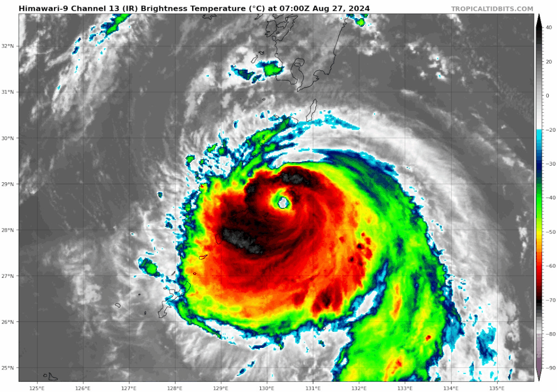
SATELLITE ANALYSIS, INITIAL POSITION AND INTENSITY DISCUSSION:
ANIMATED ENHANCED INFRARED (EIR) SATELLITE IMAGERY DEPICTS
STRUGGLING DEEP CONVECTION OBSCURING A LOW-LEVEL CIRCULATION CENTER
THAT IS CLEARLY SHEARED HIGH 20-25KT FROM THE SOUTHWEST. THE
SOUTHWESTERLY VERTICAL WIND SHEAR (VWS) IS INDUCED BY A TROPICAL
UPPER TROPOSPHERIC (TUTT) CELL LOCATED NEARBY TO THE NORTHWEST. THE
TUTT CELL IS COUNTERBALANCING THE UNFAVORABLE SHEAR BY ENCOURAGING
VERY STRONG POLEWARD OUTFLOW ALOFT. THE INITIAL POSITION IS PLACED
WITH HIGH CONFIDENCE BASED ON A 241824Z F-18 SSMIS 91GHZ IMAGE
DEPICTING THE DEEP CONVECTION DISPLACED FROM A MICROWAVE EYE-LIKE
FEATURE AND LOW-LEVEL CLOUD BANDING EXPOSED BY THE DRY AIR WRAPPING
IN FROM THE SOUTHWEST. THE INITIAL INTENSITY OF 65 KTS IS ASSESSED
WITH MEDIUM CONFIDENCE BASED ON THE AGENCY AND OBJECTIVE FIXES
LISTED BELOW ACCOMPANIED BY THE PRESENCE OF THE MICROWAVE EYE-LIKE
FEATURE.

INITIAL WIND RADII BASIS: OBJECTIVE BEST TRACK

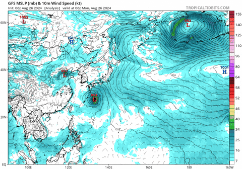
CURRENT STEERING MECHANISM: THE NORTHWESTERN PERIPHERY OF A RIDGE
TO THE WEST.

AGENCY DVORAK AND AUTOMATED FIXES:
PGTW: T4.5 - 77 KTS
RJTD: T4.0 - 65 KTS
RCTP: T4.0 - 65 KTS
KNES: T4.0 - 65 KTS
CIMSS SATCON: 60 KTS AT 241607Z
CIMSS ADT: 49 KTS AT 241730Z

FORECASTER ASSESSMENT OF CURRENT ENVIRONMENT: MARGINAL
VWS: 20-25 KTS
SST: 29-30 CELSIUS
OUTFLOW: STRONG POLEWARD

ANALYSIS CONFIDENCE:
INITIAL POSITION: HIGH
INITIAL INTENSITY: MEDIUM
INITIAL WIND RADII: LOW

3. FORECAST REASONING.

SIGNIFICANT FORECAST CHANGES: THERE ARE NO SIGNIFICANT CHANGES TO
THE FORECAST FROM THE PREVIOUS WARNING.

FORECAST DISCUSSION: TYPHOON (TY) 11W WILL TRACK NORTHWESTWARD
WHILE UNDER THE STEERING INFLUENCE OF A WEAKENING RIDGE TO THE
EAST. BETWEEN TAU 12-24, THE SYSTEM WILL COME UNDER THE STEERING
INFLUENCE OF A DIFFERENT RIDGE AND CONTINUE TO ROUND THE RIDGE
THROUGH THE END OF THE FORECAST PERIOD, TRACKING THE SYSTEM OVER
MAINLAND JAPAN BETWEEN TAU 72-96. THE SYSTEM IS FORECAST TO RESUME
INTENSIFICATION SLOWLY WITHIN THE NEXT 12 HOURS AS VWS DROPS TO
MODERATE SPEEDS (15-20KTS). VWS WILL CONTINUE TO DECREASE AS THE
TUTT CELL CONTINUES WEST ALLOWING FOR A MORE DRAMATIC
INTENSIFICATION RATE WHILE IN A FAVORABLE ENVIRONMENT OF LOW VWS,
WARM SSTS, AND STRONG UPPER-LEVEL DIVERGENCE. AFTER 72 HOURS, THE
SYSTEM WILL BEGIN TO INTERACT WITH AN UPPER-LEVEL TROUGH EXTENDING
OVER THE SEA OF JAPAN WHICH WILL INITIATE EXTRATROPICAL TRANSITION
(ETT). THE INCREASE OF VWS, INTERACTION WITH LAND, AND ETT WILL
CAUSE WEAKENING TO START AT TAU 72 THAT WILL CONTINUE TO THE END OF
THE FORECAST PERIOD WHEN THE SYSTEM BECOMES FULLY EXTRATROPICAL AT
TAU 120.

MODEL DISCUSSION: DETERMINISTIC MODEL GUIDANCE IS IN GOOD AGREEMENT
THAT THE SYSTEM WILL TRACK NORTHWESTWARD AS THE STEERING INFLUENCE
IS PICKED UP BY THE SUBTROPICAL RIDGE TO THE NORTH, BUT UNCERTAINTY
IN THE LATER FORECAST TRACK INCREASES DUE TO A WIDE CROSS-TRACK
SPREAD OF 560NM. THE LARGE SPREAD OF SOLUTIONS BETWEEN TAU 72-120
CAN BE ATTRIBUTED TO DIFFERENT INTERPRETATIONS OF HOW STRONGLY THE
SYSTEM IS STEERED BY THE SUBTROPICAL RIDGE. DIFFERENT TRACK
SOLUTIONS WILL ULTIMATELY IMPACT THE DIFFERENT SOLUTIONS OF THE
INTENSITY GUIDANCE, WHICH HAS A 70KT SPREAD AT THE PEAK INTENSITY
BETWEEN TAU 48-72. GFS, WHICH HAS A MORE NORTH-NORTHEASTERLY TRACK
OVER WARMER WATERS, FORECASTS A PEAK OF 135KTS WHILE COAMPS-TC
(NAVGEM-BASED) FORECASTS A STAGNATION OF 65KTS THROUGHOUT THE
FORECAST.
0 likes   
Visit the Caribbean-Central America Weather Thread where you can find at first post web cams,radars
and observations from Caribbean basin members Click Here

User avatar
xtyphooncyclonex
Category 5
Category 5
Posts: 3857
Age: 23
Joined: Sat Dec 08, 2012 9:07 am
Location: Cebu City
Contact:

Re: WPAC: SHANSHAN - Typhoon

#22 Postby xtyphooncyclonex » Sun Aug 25, 2024 7:15 pm

GFS and the ECMWF now see Shanshan lingering as a typhoon for days after landfall... interesting. Could spell a horrible scenario for affected areas.
0 likes   
REMINDER: My opinions that I, or any other NON Pro-Met in this forum, are unofficial. Please do not take my opinions as an official forecast and warning. I am NOT a meteorologist. Following my forecasts blindly may lead to false alarm, danger and risk if official forecasts from agencies are ignored.

User avatar
Hayabusa
Category 5
Category 5
Posts: 4244
Joined: Sun Sep 16, 2018 1:05 pm

Re: WPAC: SHANSHAN - Typhoon

#23 Postby Hayabusa » Mon Aug 26, 2024 6:37 am

06z gfs keeps it alive for the whole forecast :cheesy:
0 likes   
ヤンデレ女が寝取られるているのを見たい!!!
ECMWF ensemble NWPAC plots: https://ecmwfensnwpac.imgbb.com/
Multimodel NWPAC plots: https://multimodelnwpac.imgbb.com/
GFS Ensemble NWPAC plots (16 & 35 day forecast): https://gefsnwpac.imgbb.com/
Plots updated automatically

User avatar
REDHurricane
Category 1
Category 1
Posts: 394
Age: 27
Joined: Sun Jul 03, 2022 2:36 pm
Location: Northeast Pacific Ocean

Re: WPAC: SHANSHAN - Typhoon

#24 Postby REDHurricane » Mon Aug 26, 2024 8:26 am

Hayabusa wrote:06z gfs keeps it alive for the whole forecast :cheesy:


Wow

Image


Yeah... that could be very bad, plus another one coming right for the same area at the end. Concerning that the Euro forecast through 10 days shows a similar solution with the storm lingering/looping around off the southern coast of Japan the entire time, too. Let's just hope it doesn't do that :double:
4 likes   

User avatar
cycloneye
Admin
Admin
Posts: 143863
Age: 68
Joined: Thu Oct 10, 2002 10:54 am
Location: San Juan, Puerto Rico

Re: WPAC: SHANSHAN - Typhoon

#25 Postby cycloneye » Mon Aug 26, 2024 8:43 am

0 likes   
Visit the Caribbean-Central America Weather Thread where you can find at first post web cams,radars
and observations from Caribbean basin members Click Here

User avatar
cycloneye
Admin
Admin
Posts: 143863
Age: 68
Joined: Thu Oct 10, 2002 10:54 am
Location: San Juan, Puerto Rico

Re: WPAC: SHANSHAN - Typhoon

#26 Postby cycloneye » Mon Aug 26, 2024 8:53 am

0 likes   
Visit the Caribbean-Central America Weather Thread where you can find at first post web cams,radars
and observations from Caribbean basin members Click Here

User avatar
cycloneye
Admin
Admin
Posts: 143863
Age: 68
Joined: Thu Oct 10, 2002 10:54 am
Location: San Juan, Puerto Rico

Re: WPAC: SHANSHAN - Typhoon

#27 Postby cycloneye » Mon Aug 26, 2024 11:12 am

Image
0 likes   
Visit the Caribbean-Central America Weather Thread where you can find at first post web cams,radars
and observations from Caribbean basin members Click Here

User avatar
ElectricStorm
Category 5
Category 5
Posts: 5017
Age: 24
Joined: Tue Aug 13, 2019 11:23 pm
Location: Skiatook, OK / Norman, OK

Re: WPAC: SHANSHAN - Typhoon

#28 Postby ElectricStorm » Mon Aug 26, 2024 1:53 pm

11W SHANSHAN 240826 1800 28.0N 131.1E WPAC 95 958


Starting to look pretty good now so this may be a little low
0 likes   
I am in no way a professional. Take what I say with a grain of salt as I could be totally wrong. Please refer to the NHC, NWS, or SPC for official information.

Boomer Sooner!

User avatar
cycloneye
Admin
Admin
Posts: 143863
Age: 68
Joined: Thu Oct 10, 2002 10:54 am
Location: San Juan, Puerto Rico

Re: WPAC: SHANSHAN - Typhoon

#29 Postby cycloneye » Mon Aug 26, 2024 2:20 pm

Image
4 likes   
Visit the Caribbean-Central America Weather Thread where you can find at first post web cams,radars
and observations from Caribbean basin members Click Here

User avatar
ElectricStorm
Category 5
Category 5
Posts: 5017
Age: 24
Joined: Tue Aug 13, 2019 11:23 pm
Location: Skiatook, OK / Norman, OK

Re: WPAC: SHANSHAN - Typhoon

#30 Postby ElectricStorm » Tue Aug 27, 2024 1:01 am

0z GFS loops it all the way back SW and clips Taiwan before heading into China on September 7. Some of these GFS runs for this storm have been wild :lol:
1 likes   
I am in no way a professional. Take what I say with a grain of salt as I could be totally wrong. Please refer to the NHC, NWS, or SPC for official information.

Boomer Sooner!

User avatar
Hayabusa
Category 5
Category 5
Posts: 4244
Joined: Sun Sep 16, 2018 1:05 pm

Re: WPAC: SHANSHAN - Typhoon

#31 Postby Hayabusa » Tue Aug 27, 2024 5:55 am

ElectricStorm wrote:0z GFS loops it all the way back SW and clips Taiwan before heading into China on September 7. Some of these GFS runs for this storm have been wild :lol:

GFS 06Z similar scenario but longer timespan and more north, if this really happens Shanshan has yet to peak and it would be a big ACE maker...
Image
1 likes   
ヤンデレ女が寝取られるているのを見たい!!!
ECMWF ensemble NWPAC plots: https://ecmwfensnwpac.imgbb.com/
Multimodel NWPAC plots: https://multimodelnwpac.imgbb.com/
GFS Ensemble NWPAC plots (16 & 35 day forecast): https://gefsnwpac.imgbb.com/
Plots updated automatically

underthwx
Category 5
Category 5
Posts: 2351
Joined: Sat Jul 30, 2011 2:14 pm
Location: Brazoria County Texas

Re: WPAC: SHANSHAN - Typhoon

#32 Postby underthwx » Tue Aug 27, 2024 7:19 am


Powerful looking cyclone.....
0 likes   

underthwx
Category 5
Category 5
Posts: 2351
Joined: Sat Jul 30, 2011 2:14 pm
Location: Brazoria County Texas

Re: WPAC: SHANSHAN - Typhoon

#33 Postby underthwx » Tue Aug 27, 2024 7:23 am

Hayabusa wrote:
ElectricStorm wrote:0z GFS loops it all the way back SW and clips Taiwan before heading into China on September 7. Some of these GFS runs for this storm have been wild :lol:

GFS 06Z similar scenario but longer timespan and more north, if this really happens Shanshan has yet to peak and it would be a big ACE maker...
https://i.imgur.com/KRWRHSr.png

Wassup Hayabusa?....hope all is well there my friend...gonna be seeing yall soon!....so...my questikn....what are the odds of this cyclone making the loop around yall mention?...thanks bro..
0 likes   

User avatar
Teban54
Category 5
Category 5
Posts: 3168
Joined: Sat May 19, 2018 1:19 pm

Re: WPAC: SHANSHAN - Typhoon

#34 Postby Teban54 » Tue Aug 27, 2024 7:31 am

Image
3 likes   

User avatar
cycloneye
Admin
Admin
Posts: 143863
Age: 68
Joined: Thu Oct 10, 2002 10:54 am
Location: San Juan, Puerto Rico

Re: WPAC: SHANSHAN - Typhoon

#35 Postby cycloneye » Tue Aug 27, 2024 8:39 am

0 likes   
Visit the Caribbean-Central America Weather Thread where you can find at first post web cams,radars
and observations from Caribbean basin members Click Here

User avatar
xtyphooncyclonex
Category 5
Category 5
Posts: 3857
Age: 23
Joined: Sat Dec 08, 2012 9:07 am
Location: Cebu City
Contact:

Re: WPAC: SHANSHAN - Typhoon

#36 Postby xtyphooncyclonex » Tue Aug 27, 2024 9:57 am

Shanshan may be exploding right now

 https://x.com/Sekai_WX/status/1828446301450838261


0 likes   
REMINDER: My opinions that I, or any other NON Pro-Met in this forum, are unofficial. Please do not take my opinions as an official forecast and warning. I am NOT a meteorologist. Following my forecasts blindly may lead to false alarm, danger and risk if official forecasts from agencies are ignored.

User avatar
ElectricStorm
Category 5
Category 5
Posts: 5017
Age: 24
Joined: Tue Aug 13, 2019 11:23 pm
Location: Skiatook, OK / Norman, OK

Re: WPAC: SHANSHAN - Typhoon

#37 Postby ElectricStorm » Tue Aug 27, 2024 10:30 am

There's no way this is only 5 kts stronger than it was 12 hours ago. Likely well into Cat 4 range
0 likes   
I am in no way a professional. Take what I say with a grain of salt as I could be totally wrong. Please refer to the NHC, NWS, or SPC for official information.

Boomer Sooner!

User avatar
aspen
Category 5
Category 5
Posts: 8812
Joined: Sat Oct 12, 2019 7:10 pm
Location: Connecticut, USA

Re: WPAC: SHANSHAN - Typhoon

#38 Postby aspen » Tue Aug 27, 2024 2:41 pm

Structurally, this looks a lot like Dorian, with a large clear eye and a thick ring of fairly warm cloud tops. The smoothness of the CDO and eye imply a higher intensity than what ADT can yield. However, it’s definitely not as good as Dorian, so it’s probably “only” around 130-140 kt.

Up to 115 kt at 18z but that’s still WAY too low. Shanshan is trying to beat out Gilma for the most underestimated storm of the year so far.
1 likes   
Irene '11 Sandy '12 Hermine '16 5/15/2018 Derecho Fay '20 Isaias '20 Elsa '21 Henri '21 Ida '21

I am only a meteorology enthusiast who knows a decent amount about tropical cyclones. Look to the professional mets, the NHC, or your local weather office for the best information.

User avatar
Hayabusa
Category 5
Category 5
Posts: 4244
Joined: Sun Sep 16, 2018 1:05 pm

Re: WPAC: SHANSHAN - Typhoon

#39 Postby Hayabusa » Tue Aug 27, 2024 3:06 pm

underthwx wrote:
Hayabusa wrote:
ElectricStorm wrote:0z GFS loops it all the way back SW and clips Taiwan before heading into China on September 7. Some of these GFS runs for this storm have been wild :lol:

GFS 06Z similar scenario but longer timespan and more north, if this really happens Shanshan has yet to peak and it would be a big ACE maker...
https://i.imgur.com/KRWRHSr.png

Wassup Hayabusa?....hope all is well there my friend...gonna be seeing yall soon!....so...my questikn....what are the odds of this cyclone making the loop around yall mention?...thanks bro..

It's hard to say 12Z GFS remains the same scenario while Euro still recurving but seems to be trending on a slower NE track.
And also latest 12Z Euro ensemble is latching on to the GFS operational solution, we'll see if the operational Euro caves to the GFS. As a TC watcher the GFS solution would be very interesting to watch than plain old recurvature.
Image
1 likes   
ヤンデレ女が寝取られるているのを見たい!!!
ECMWF ensemble NWPAC plots: https://ecmwfensnwpac.imgbb.com/
Multimodel NWPAC plots: https://multimodelnwpac.imgbb.com/
GFS Ensemble NWPAC plots (16 & 35 day forecast): https://gefsnwpac.imgbb.com/
Plots updated automatically

User avatar
xtyphooncyclonex
Category 5
Category 5
Posts: 3857
Age: 23
Joined: Sat Dec 08, 2012 9:07 am
Location: Cebu City
Contact:

Re: WPAC: SHANSHAN - Typhoon

#40 Postby xtyphooncyclonex » Tue Aug 27, 2024 6:05 pm

The resemblance was so uncanny I had to double check whether this was edited lol

 https://x.com/WeatherS76611/status/1828543122994811209


4 likes   
REMINDER: My opinions that I, or any other NON Pro-Met in this forum, are unofficial. Please do not take my opinions as an official forecast and warning. I am NOT a meteorologist. Following my forecasts blindly may lead to false alarm, danger and risk if official forecasts from agencies are ignored.


Return to “2024”

Who is online

Users browsing this forum: No registered users and 11 guests