The moist Sahara Dessert factor.
https://x.com/CraigSetzer/status/1828399315200421973
2024 Indicators: SST's, MSLP, Shear, SAL, Steering, Instability (Day 16+ Climate Models)
Moderator: S2k Moderators
Forum rules

The posts in this forum are NOT official forecasts and should not be used as such. They are just the opinion of the poster and may or may not be backed by sound meteorological data. They are NOT endorsed by any professional institution or STORM2K. For official information, please refer to products from the National Hurricane Center and National Weather Service.
-
cycloneye

- Admin

- Posts: 149266
- Age: 69
- Joined: Thu Oct 10, 2002 10:54 am
- Location: San Juan, Puerto Rico
Re: 2024 Indicators: SST's, MSLP, Shear, SAL, Steering, Instability (Day 16+ Climate Models)
2 likes
Visit the Caribbean-Central America Weather Thread where you can find at first post web cams,radars
and observations from Caribbean basin members Click Here
and observations from Caribbean basin members Click Here
-
SFLcane

- S2K Supporter

- Posts: 10281
- Age: 48
- Joined: Sat Jun 05, 2010 1:44 pm
- Location: Lake Worth Florida
Re: 2024 Indicators: SST's, MSLP, Shear, SAL, Steering, Instability (Day 16+ Climate Models)
Never thought I’d be reading these conversations on S2K less then 2 weeks to peak on a 230 ace prediction from @philklotzbach in 2024. Still sometime for things to turn around but no real substantial evidence of that yet.
2 likes
-
toad strangler

- S2K Supporter
- Posts: 4546
- Joined: Sun Jul 28, 2013 3:09 pm
- Location: Earth
- Contact:
Re: 2024 Indicators: SST's, MSLP, Shear, SAL, Steering, Instability (Day 16+ Climate Models)
SFLcane wrote:Never thought I’d be reading these conversations on S2K less then 2 weeks to peak on a 230 ace prediction from @philklotzbach in 2024. Still sometime for things to turn around but no real substantial evidence of that yet.
Only 174.9 to go!
1 likes
My Weather Station
https://www.wunderground.com/dashboard/pws/KFLPORTS603
https://www.wunderground.com/dashboard/pws/KFLPORTS603
-
cycloneye
- Admin
- Posts: 149266
- Age: 69
- Joined: Thu Oct 10, 2002 10:54 am
- Location: San Juan, Puerto Rico
Re: 2024 Indicators: SST's, MSLP, Shear, SAL, Steering, Instability (Day 16+ Climate Models)
Well, it looks like +200 ACE is not going to occur according to this great model that WeatherTiger has.
https://x.com/wx_tiger/status/1828441846076330324
https://x.com/wx_tiger/status/1828441846076330324
0 likes
Visit the Caribbean-Central America Weather Thread where you can find at first post web cams,radars
and observations from Caribbean basin members Click Here
and observations from Caribbean basin members Click Here
-
cycloneye
- Admin
- Posts: 149266
- Age: 69
- Joined: Thu Oct 10, 2002 10:54 am
- Location: San Juan, Puerto Rico
Re: 2024 Indicators: SST's, MSLP, Shear, SAL, Steering, Instability (Day 16+ Climate Models)
0 likes
Visit the Caribbean-Central America Weather Thread where you can find at first post web cams,radars
and observations from Caribbean basin members Click Here
and observations from Caribbean basin members Click Here

Re: 2024 Indicators: SST's, MSLP, Shear, SAL, Steering, Instability (Day 16+ Climate Models)
I don’t think anyone expected to see a chart like that back in July.
Even with Beryl, I think this season will struggle to even hit 150 ACE if this persists.
0 likes
Irene '11 Sandy '12 Hermine '16 5/15/2018 Derecho Fay '20 Isaias '20 Elsa '21 Henri '21 Ida '21
I am only a meteorology enthusiast who knows a decent amount about tropical cyclones. Look to the professional mets, the NHC, or your local weather office for the best information.
I am only a meteorology enthusiast who knows a decent amount about tropical cyclones. Look to the professional mets, the NHC, or your local weather office for the best information.
-
MarioProtVI
- Category 5

- Posts: 1034
- Age: 24
- Joined: Sun Sep 29, 2019 7:33 pm
- Location: New Jersey
Re: 2024 Indicators: SST's, MSLP, Shear, SAL, Steering, Instability (Day 16+ Climate Models)
I don’t really buy that map at all given how bad models have been this year.
1 likes
Re: 2024 Indicators: SST's, MSLP, Shear, SAL, Steering, Instability (Day 16+ Climate Models)
SFLcane wrote:Never thought I’d be reading these conversations on S2K less then 2 weeks to peak on a 230 ace prediction from @philklotzbach in 2024. Still sometime for things to turn around but no real substantial evidence of that yet.
Here is fwiw a copy of some excerpts from a post I made on 4/7/24 regarding the extremely bullish April CSU forecast:
“I see a pretty clear pattern when they’ve gone very active in April:
2. NS days: They’re predicting 115. Prior to this the highest they predicted in April was 85-95 (four times). All four of those progs ended up too high. The highest actual of those four was only 58 and they averaged a whopping 40.5 too high!
3. # H: They’re predicting 11. The prior highest predicted in April was 9 (six times). All of those 6 progs ended up too high by an average of 3.
7. ACE: They’re predicting 210. The prior highest predicted in April were 160-183 (five times). Of these five, all progs ended up too high with even the closest still being 34 too high! The five averaged a whopping 85.8 too high!
Conclusion: If I were a betting man, I’d short CSU’s April ‘24’s forecast overall, especially NS Days, # H, and ACE.”
https://www.storm2k.org/phpbb2/viewtopi ... 0#p3063020
0 likes
Personal Forecast Disclaimer:
The posts in this forum are NOT official forecasts and should not be used as such. They are just the opinion of the poster and may or may not be backed by sound meteorological data. They are NOT endorsed by any professional institution or storm2k.org. For official information, please refer to the NHC and NWS products.
The posts in this forum are NOT official forecasts and should not be used as such. They are just the opinion of the poster and may or may not be backed by sound meteorological data. They are NOT endorsed by any professional institution or storm2k.org. For official information, please refer to the NHC and NWS products.
-
cycloneye
- Admin
- Posts: 149266
- Age: 69
- Joined: Thu Oct 10, 2002 10:54 am
- Location: San Juan, Puerto Rico
Re: 2024 Indicators: SST's, MSLP, Shear, SAL, Steering, Instability (Day 16+ Climate Models)
1 likes
Visit the Caribbean-Central America Weather Thread where you can find at first post web cams,radars
and observations from Caribbean basin members Click Here
and observations from Caribbean basin members Click Here

Re: 2024 Indicators: SST's, MSLP, Shear, SAL, Steering, Instability (Day 16+ Climate Models)
LarryWx wrote:SFLcane wrote:Never thought I’d be reading these conversations on S2K less then 2 weeks to peak on a 230 ace prediction from @philklotzbach in 2024. Still sometime for things to turn around but no real substantial evidence of that yet.
Here is fwiw a copy of some excerpts from a post I made on 4/7/24 regarding the extremely bullish April CSU forecast:
“I see a pretty clear pattern when they’ve gone very active in April:
2. NS days: They’re predicting 115. Prior to this the highest they predicted in April was 85-95 (four times). All four of those progs ended up too high. The highest actual of those four was only 58 and they averaged a whopping 40.5 too high!
3. # H: They’re predicting 11. The prior highest predicted in April was 9 (six times). All of those 6 progs ended up too high by an average of 3.
7. ACE: They’re predicting 210. The prior highest predicted in April were 160-183 (five times). Of these five, all progs ended up too high with even the closest still being 34 too high! The five averaged a whopping 85.8 too high!
Conclusion: If I were a betting man, I’d short CSU’s April ‘24’s forecast overall, especially NS Days, # H, and ACE.”
https://www.storm2k.org/phpbb2/viewtopi ... 0#p3063020
EXCELLENT points made at that juncture (though in spite of that sentiment, "something" did sway you to ultimately predict a fairly high number of NS & Hurricanes as well - 21/10/5 ACE: 176 on that same day
1 likes
Andy D
(For official information, please refer to the NHC and NWS products.)
(For official information, please refer to the NHC and NWS products.)
-
SFLcane
- S2K Supporter
- Posts: 10281
- Age: 48
- Joined: Sat Jun 05, 2010 1:44 pm
- Location: Lake Worth Florida
Re: 2024 Indicators: SST's, MSLP, Shear, SAL, Steering, Instability (Day 16+ Climate Models)
Been tracking hurricanes since 92 after loosing everything i owend to andrew and i must say "wow" not sure what to think but one being i was not expecting this outcome thus far being this is 2024 and seasonal forecast have a come a long ways. I think the hyperactive numbers are probably toast but i think its important to remember the potential for " impacts " is unchanged and will be with us for long while. Nothing is ever a sure thing in weather we still have lots to learn about our atmosphere.
1 likes
-
jlauderdal
- S2K Supporter
- Posts: 7240
- Joined: Wed May 19, 2004 5:46 am
- Location: NE Fort Lauderdale
- Contact:
Re: 2024 Indicators: SST's, MSLP, Shear, SAL, Steering, Instability (Day 16+ Climate Models)
SFLcane wrote:Been tracking hurricanes since 92 after loosing everything i owend to andrew and i must say "wow" not sure what to think but one being i was not expecting this outcome thus far being this is 2024 and seasonal forecast have a come a long ways. I think the hyperactive numbers are probably toast but i think its important to remember the potential for " impacts " is unchanged and will be with us for long while. Nothing is ever a sure thing in weather we still have lots to learn about our atmosphere.
Whether we get the bg season numbers or not, we still have to get through October. The waters are warm, hurricanes exist to transport energy, something is going to happen to move that energy around.
0 likes
-
CyclonicFury

- Category 5
- Posts: 2032
- Age: 27
- Joined: Sun Jul 02, 2017 12:32 pm
- Location: NC
- Contact:
Re: 2024 Indicators: SST's, MSLP, Shear, SAL, Steering, Instability (Day 16+ Climate Models)
I still think it's way too early to assume the rest of the season will be quieter than normal, September hasn't even started yet and although the AOI signal downticked it's fairly common for models to fluctuate. We still have September, October and even November to get through. While this lull significantly decreases the chances of an ultra-hyperactive season, it doesn't mean the Atlantic will stay hostile throughout the entire season. After Earl in 2022 I remember a lot of people were speculating the season would be very quiet the rest of the way and there was two major hurricanes in the second half of September. I still think 2024 likely ends up more active than 2022 in most metrics.
After all, we've already seen the Atlantic produce three hurricanes including an unprecedented late June MDR major, it's not like the Atlantic has been unusually hostile all season. I don't think that Beryl could've possibly meant nothing in the end. I think it's more likely than not this basin produces something within the next week.
After all, we've already seen the Atlantic produce three hurricanes including an unprecedented late June MDR major, it's not like the Atlantic has been unusually hostile all season. I don't think that Beryl could've possibly meant nothing in the end. I think it's more likely than not this basin produces something within the next week.
Last edited by CyclonicFury on Tue Aug 27, 2024 3:03 pm, edited 1 time in total.
3 likes
NCSU B.S. in Meteorology Class of 2021. Tropical weather blogger at http://www.cyclonicfury.com. My forecasts and thoughts are NOT official, for official forecasts please consult the National Hurricane Center.
Re: 2024 Indicators: SST's, MSLP, Shear, SAL, Steering, Instability (Day 16+ Climate Models)
This last week has reminded me a lot of August 2022, when we were all watching any sign of life on the models, and every potential MDR signal just fizzled out until Earl in early September (which underperformed similarly to Ernesto).
I’d say the odds of an across-the-board bust (not just in NS) is growing by the day. Even with the insane head-start from Beryl, we’ll still fall behind most or all metrics if we see 2022-ish or average activity from here on out. Maybe we’ll see a delayed peak from the second half of September to early October as the monsoon dips south and breaks up, but it’s too early to tell. However, if the rest of the season ends up anything like 2022, then it could continue to be quite a high-impact year despite the much lower-than-expected seasonal numbers.
Thinking 13-17 NS, 5-8 H, 3-5 MH, and 110-160 ACE right now.
2 likes
Irene '11 Sandy '12 Hermine '16 5/15/2018 Derecho Fay '20 Isaias '20 Elsa '21 Henri '21 Ida '21
I am only a meteorology enthusiast who knows a decent amount about tropical cyclones. Look to the professional mets, the NHC, or your local weather office for the best information.
I am only a meteorology enthusiast who knows a decent amount about tropical cyclones. Look to the professional mets, the NHC, or your local weather office for the best information.
-
Spacecoast

- Category 2

- Posts: 773
- Joined: Thu Aug 31, 2017 2:03 pm
Re: 2024 Indicators: SST's, MSLP, Shear, SAL, Steering, Instability (Day 16+ Climate Models)
.."Maybe we’ll see a delayed peak from the second half of September to early October"...
Many have observed / posited that Hurricane seasons have become more 'backloaded' in recent years.
Is this true? Have some free time, (I hope this is right thread to post, forgive me if not),....
I'm sure everyone recognizes this NOAA graphic:

figure a: Hurricane and Tropical Storm climatology (years 1944 to 2020) *courtesy NOAA
Using HURRDAT2 data , I have recreated / updated this distribution graphic using weekly 1950-2023 climatology:

figure b: 1950-2023 weekly Hurricane formation. Source: using latest HURRDAT2 data
This shows basically the same distribution as NOAA's 1944-2020 graphic. It illustrates what statisticians call a 'normal distribution', with peak of Sept 11th (week ending 9/13), and an equal percentage (~43%) of H's forming before, and after the peak (Sept 11th). *Note that this is an average of 73 years. It may not represent recent distribution, or any given year's distribution. Useful as a baseline.
To find out if seasons are becoming more backloaded, Split the data into two 36 year groups: 1951-1986, and 1987-2023, then compare results:

This shows that during 1951-1986 timeframe hurricane formation was slightly frontloaded, with 46% occurring before a Sept 8th 'peak', and 39% occurring after.

figure c: Distribution of H formation comparing early satellite era, to post-1987 timeframe.
In comparison, the 1987-2023 timeframe shows a slightly backloaded distribution, with 41.5% occurring before a flattened 'peak' of Sept 14th, and 46.5% occurring after.
To further illustrate this shift, plot the last 18 years:

figure d: Weekly distribution / Peak Hurricane formation 2006-2023
This shows that during the last 18 years, seasons have became slightly more backloaded relative to NOAA's climatology, and the new peak occurs week ending 9/20 (specifically 9/14). A slightly less dramatic post peak drop-off is noted as well as an uptick in Nov. activity.
So... yes, there is still hope for 2024.
5 likes
Re: 2024 Indicators: SST's, MSLP, Shear, SAL, Steering, Instability (Day 16+ Climate Models)
chaser1 wrote:LarryWx wrote:SFLcane wrote:Never thought I’d be reading these conversations on S2K less then 2 weeks to peak on a 230 ace prediction from @philklotzbach in 2024. Still sometime for things to turn around but no real substantial evidence of that yet.
Here is fwiw a copy of some excerpts from a post I made on 4/7/24 regarding the extremely bullish April CSU forecast:
“I see a pretty clear pattern when they’ve gone very active in April:
2. NS days: They’re predicting 115. Prior to this the highest they predicted in April was 85-95 (four times). All four of those progs ended up too high. The highest actual of those four was only 58 and they averaged a whopping 40.5 too high!
3. # H: They’re predicting 11. The prior highest predicted in April was 9 (six times). All of those 6 progs ended up too high by an average of 3.
7. ACE: They’re predicting 210. The prior highest predicted in April were 160-183 (five times). Of these five, all progs ended up too high with even the closest still being 34 too high! The five averaged a whopping 85.8 too high!
Conclusion: If I were a betting man, I’d short CSU’s April ‘24’s forecast overall, especially NS Days, # H, and ACE.”
https://www.storm2k.org/phpbb2/viewtopi ... 0#p3063020
EXCELLENT points made at that juncture (though in spite of that sentiment, "something" did sway you to ultimately predict a fairly high number of NS & Hurricanes as well - 21/10/5 ACE: 176 on that same day)
Thank you. I was talking to “betting” men, which I’m not.
Seriously, when I made my S2K prediction, I still went very active as you said though not hyperactive with 21/10/5 176. My ACE was exactly 34 below their 210 ACE based on this analysis, showing they were 34+ too high all 5 of those times. I didn’t feel comfy going lower because at the time the vast majority of the ~50 earlier S2K ACE picks were higher than 176. So, for contest purposes, I thought it was wise to hedge on the higher side of my range. Same with the NS. Most were above my 21. And my 21 was 2 lower than CSU’s 33. My 10H was also lower than most others. My 5MH was near the median.
0 likes
Personal Forecast Disclaimer:
The posts in this forum are NOT official forecasts and should not be used as such. They are just the opinion of the poster and may or may not be backed by sound meteorological data. They are NOT endorsed by any professional institution or storm2k.org. For official information, please refer to the NHC and NWS products.
The posts in this forum are NOT official forecasts and should not be used as such. They are just the opinion of the poster and may or may not be backed by sound meteorological data. They are NOT endorsed by any professional institution or storm2k.org. For official information, please refer to the NHC and NWS products.
Re: 2024 Indicators: SST's, MSLP, Shear, SAL, Steering, Instability (Day 16+ Climate Models)
Spacecoast wrote:.."Maybe we’ll see a delayed peak from the second half of September to early October"...
Many have observed / posited that Hurricane seasons have become more 'backloaded' in recent years.
Is this true? Have some free time, (I hope this is right thread to post, forgive me if not),....
I'm sure everyone recognizes this NOAA graphic:
https://i.ibb.co/N11J1QR/dista.jpg
figure a: Hurricane and Tropical Storm climatology (years 1944 to 2020) *courtesy NOAA
Using HURRDAT2 data , I have recreated / updated this distribution graphic using weekly 1950-2023 climatology:
https://i.ibb.co/FsBFk0m/distb.jpg
figure b: 1950-2023 weekly Hurricane formation. Source: using latest HURRDAT2 data
This shows basically the same distribution as NOAA's 1944-2020 graphic. It illustrates what statisticians call a 'normal distribution', with peak of Sept 11th (week ending 9/13), and an equal percentage (~43%) of H's forming before, and after the peak (Sept 11th). *Note that this is an average of 73 years. It may not represent recent distribution, or any given year's distribution. Useful as a baseline.
To find out if seasons are becoming more backloaded, Split the data into two 36 year groups: 1951-1986, and 1987-2023, then compare results:
https://i.ibb.co/PzXbH3D/distc.jpg
This shows that during 1951-1986 timeframe hurricane formation was slightly frontloaded, with 46% occurring before a Sept 8th 'peak', and 39% occurring after.
https://i.ibb.co/SJgYb9w/distd.jpg
figure c: Distribution of H formation comparing early satellite era, to post-1987 timeframe.
In comparison, the 1987-2023 timeframe shows a slightly backloaded distribution, with 41.5% occurring before a flattened 'peak' of Sept 14th, and 46.5% occurring after.
To further illustrate this shift, plot the last 18 years:
https://i.ibb.co/ctQcbBX/diste.jpg
figure d: Weekly distribution / Peak Hurricane formation 2006-2023
This shows that during the last 18 years, seasons have became slightly more backloaded relative to NOAA's climatology, and the new peak occurs week ending 9/20 (specifically 9/14). A slightly less dramatic post peak drop-off is noted as well as an uptick in Nov. activity.
So... yes, there is still hope for 2024.
Very interesting. Note that there’s also a small peak in early/mid July that’s appeared during the last 36 years, something that we’ve seen for the last few seasons (including this one).
If this year requires the monsoon trough to move south enough and weaken enough for the lid to finally come off, I could see the peak of the season around the same time, if not a week after, as the peak in the 2006-23 graphic.
0 likes
Irene '11 Sandy '12 Hermine '16 5/15/2018 Derecho Fay '20 Isaias '20 Elsa '21 Henri '21 Ida '21
I am only a meteorology enthusiast who knows a decent amount about tropical cyclones. Look to the professional mets, the NHC, or your local weather office for the best information.
I am only a meteorology enthusiast who knows a decent amount about tropical cyclones. Look to the professional mets, the NHC, or your local weather office for the best information.

Re: 2024 Indicators: SST's, MSLP, Shear, SAL, Steering, Instability (Day 16+ Climate Models)
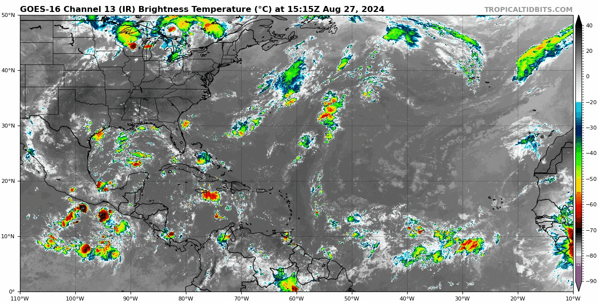
Given that a few days ago people were saying you couldn't even buy a thunderstorm in the Atlantic, the basin today is quite convectively active, honestly.
1 likes
TC naming lists: retirements and intensity
Most aggressive Advisory #1's in North Atlantic (cr. kevin for starting the list)
Most aggressive Advisory #1's in North Atlantic (cr. kevin for starting the list)


Re: 2024 Indicators: SST's, MSLP, Shear, SAL, Steering, Instability (Day 16+ Climate Models)
Teban54 wrote:Given that a few days ago people were saying you couldn't even buy a thunderstorm in the Atlantic, the basin today is quite convectively active, honestly.
https://i.postimg.cc/brW2snGy/goes16-ir-atl.gif
It sure is, but it forming a tropical cyclone is still likely a different matter. Model guidance has really backed off the last day or so, especially the EURO and honestly that’s the only model I trust given the GFS has missed every storm up to this point if memory serves, so can’t start trusting it now just because it shows something. Most likely the Atlantic continues to struggle because of the background state which is supposedly favorable but very clearly is not at this point. Something should give over the next few weeks and we see a couple storms, probably similar to 2014 style but that’s the ceiling imo.
1 likes
Re: 2024 Indicators: SST's, MSLP, Shear, SAL, Steering, Instability (Day 16+ Climate Models)
WiscoWx02 wrote:Teban54 wrote:Given that a few days ago people were saying you couldn't even buy a thunderstorm in the Atlantic, the basin today is quite convectively active, honestly.
https://i.postimg.cc/brW2snGy/goes16-ir-atl.gif
It sure is, but it forming a tropical cyclone is still likely a different matter. Model guidance has really backed off the last day or so, especially the EURO and honestly that’s the only model I trust given the GFS has missed every storm up to this point if memory serves, so can’t start trusting it now just because it shows something. Most likely the Atlantic continues to struggle because of the background state which is supposedly favorable but very clearly is not at this point. Something should give over the next few weeks and we see a couple storms, probably similar to 2014 style but that’s the ceiling imo.
0 likes
Who is online
Users browsing this forum: vbhoutex and 62 guests