2024 Global Model Runs Discussion (Out thru day 16)

This is the general tropical discussion area. Anyone can take their shot at predicting a storms path.

Moderator: S2k Moderators

Forum rules

The posts in this forum are NOT official forecasts and should not be used as such. They are just the opinion of the poster and may or may not be backed by sound meteorological data. They are NOT endorsed by any professional institution or STORM2K. For official information, please refer to products from the National Hurricane Center and National Weather Service.

Help Support Storm2K
Message
Author
User avatar
Steve
S2K Supporter
S2K Supporter
Posts: 9591
Joined: Sat Apr 05, 2003 11:41 pm
Location: Not a state-caster

Re: 2024 Global Model Runs Discussion (Out thru day 16)

#1581 Postby Steve » Tue Aug 27, 2024 2:03 pm

Stratton23 wrote:Stormlover70 I still havent figured out how to post pictures on here, but if you search up global tropical hazard outlook noaa, it should pop up right away


Can only hotlink from official sites otherwise you have to upload to an image host and link from there. Take the spaces out of the bracket and you do it as follows:

1) Right click on the image you want to link
2) Copy Image Address
3) with the spaces removed out of the brackets [ img ]https.imageaddresspaste.jpg[ / img ]

You can also copy the link and use the "Img" button above in the word processing commands. FWIW this is mostly for Desktop as mobile works differently where you can even get a link.
2 likes   

User avatar
Steve
S2K Supporter
S2K Supporter
Posts: 9591
Joined: Sat Apr 05, 2003 11:41 pm
Location: Not a state-caster

Re: 2024 Global Model Runs Discussion (Out thru day 16)

#1582 Postby Steve » Tue Aug 27, 2024 2:07 pm

Here's an example for using the MJO.

so I type without the spaces [ img ] https://www.cpc.ncep.noaa.gov/products/ ... R/CANM.png [ / img ]

And you get Image
1 likes   

User avatar
Teban54
Category 5
Category 5
Posts: 3168
Joined: Sat May 19, 2018 1:19 pm

Re: 2024 Global Model Runs Discussion (Out thru day 16)

#1583 Postby Teban54 » Tue Aug 27, 2024 3:57 pm

Teban54 wrote:12z GFS develops a wave that exits Africa on 8/31, after the yellow AOI.

Edit: This wave was on operational GFS for a few runs before, albeit inconsistently. Also some support from GEFS.

https://i.postimg.cc/jjb1Jgnj/gfs-z850-vort-atl-fh102-360.gif

12z Euro also develops the same wave (the one behind the yellow AOI) as 12z GFS does, even though it's still quite broad by the end of the public run at 240 hrs.

Excellent agreement on the location and state of the system at the 240 hrs mark: (You can also see ECMWF's bias of developing TCs inside Africa)

Edit: This may also be the reason why both operational models dropped the 0/20 AOI, as the two systems are quite close to each other. There have been plenty of examples of simultaneous developments this close, though.

Image
3 likes   

Stratton23
Category 5
Category 5
Posts: 2370
Joined: Fri Jul 21, 2023 10:59 pm
Location: Katy, Tx

Re: 2024 Global Model Runs Discussion (Out thru day 16)

#1584 Postby Stratton23 » Tue Aug 27, 2024 5:58 pm

18z GEFS signal growing for something to develop in the NW gulf off the texas coastline about 6 days from now
2 likes   

User avatar
Teban54
Category 5
Category 5
Posts: 3168
Joined: Sat May 19, 2018 1:19 pm

Re: 2024 Global Model Runs Discussion (Out thru day 16)

#1585 Postby Teban54 » Tue Aug 27, 2024 6:32 pm

Teban54 wrote:
Teban54 wrote:12z GFS develops a wave that exits Africa on 8/31, after the yellow AOI.

Edit: This wave was on operational GFS for a few runs before, albeit inconsistently. Also some support from GEFS.

https://i.postimg.cc/jjb1Jgnj/gfs-z850-vort-atl-fh102-360.gif

12z Euro also develops the same wave (the one behind the yellow AOI) as 12z GFS does, even though it's still quite broad by the end of the public run at 240 hrs.

Excellent agreement on the location and state of the system at the 240 hrs mark: (You can also see ECMWF's bias of developing TCs inside Africa)

Edit: This may also be the reason why both operational models dropped the 0/20 AOI, as the two systems are quite close to each other. There have been plenty of examples of simultaneous developments this close, though.

https://i.postimg.cc/FRZtZt38/ezgif-2-c3880d64ae.gif

18z GFS peaks it at a 1011 mb low/TD, but it seems to be solely because it tries to develop another system just to the east (that does get down to 1006 mb) and wasn't sure which one it wanted. Looks bogus to me and might be a result of convective feedback.

Image
0 likes   

TomballEd
Category 2
Category 2
Posts: 580
Age: 61
Joined: Wed Aug 16, 2023 4:52 pm
Location: Spring/Klein area, not Tomball

Re: 2024 Global Model Runs Discussion (Out thru day 16)

#1586 Postby TomballEd » Tue Aug 27, 2024 6:35 pm

I really thought the mid-Atlantic AOI was really going to do something, it had support from the big 3 models and their ensembles. Welp, 2024. Now back to some GEFS support for a 'then a miracle happened' vort that starts developing over Venezula on Saturday morning that may produce, per the ensembles that show it, a storm generallly TD or TS strength.. If it develops. A mid level low has produced a few thunderstorms around here yesterday and today, but Beryl was still the last real rain IMBY. Weak tropical systems that keep moving are my friend.. I see the 971 mb into Matagorda Bay, it could happen, but the odds aren't high. I think the 20% 7 day lemon rapidly losing model support (see other thread) is more likely to still develop than anything in the W. Gulf from mysterious provenance.

The climatological peak in two weeks could have no storms anywhere in the basin. This will be a season for some serious post-season review. Abnormally warm SSTs alone don't guarantee a hyperactive season. I still have a feeling another bad one will hit somewhere this year. The warm water has to produce a bad one, especially when the upper atmosphere is cooling more rapidly than the ocean surface (increased instability) and their can be baroclinic enhancement. Which storm will be this years Ian?
0 likes   

User avatar
Blown Away
S2K Supporter
S2K Supporter
Posts: 10140
Joined: Wed May 26, 2004 6:17 am

Re: 2024 Global Model Runs Discussion (Out thru day 16)

#1587 Postby Blown Away » Tue Aug 27, 2024 6:35 pm

GFS out to Sept 12th with no hint of a hurricane… Crazy!

Did the long range seasonal models pickup on this inactivity?
0 likes   
Hurricane Eye Experience: David 79, Irene 99, Frances 04, Jeanne 04, Wilma 05... EYE COMING MY WAY IN 2024…
Hurricane Brush Experience: Andrew 92, Erin 95, Floyd 99, Matthew 16, Irma 17, Ian 22, Nicole 22…

Stratton23
Category 5
Category 5
Posts: 2370
Joined: Fri Jul 21, 2023 10:59 pm
Location: Katy, Tx

Re: 2024 Global Model Runs Discussion (Out thru day 16)

#1588 Postby Stratton23 » Tue Aug 27, 2024 6:41 pm

TomballEd the euro also shows a disturbance in the western gulf, its not some GFS phantom vort, the ensembles and some operational guidance are seeing an area of storms between the yucatan and cuba, eventually make its way toward the texas coast, its worth watching for sure, the CPC even has a highlights zone risk for the yucatan- southern gulf, so it is worth some attention in the 5-7 day range
Last edited by Stratton23 on Tue Aug 27, 2024 6:43 pm, edited 1 time in total.
0 likes   

tolakram
Admin
Admin
Posts: 19990
Age: 61
Joined: Sun Aug 27, 2006 8:23 pm
Location: Florence, KY (name is Mark)

Re: 2024 Global Model Runs Discussion (Out thru day 16)

#1589 Postby tolakram » Tue Aug 27, 2024 9:16 pm

I had to remove a few posts. Please, if you find yourself posting a snarky comment that is not related to a model run or doesn't add anything of value to the conversation then don't post. Worse, if you find yourself telling people it's not the time to discuss something then you're in the wrong thread, hit the back button.

If you want to discuss something but it's more seasonal in nature, that's great, please do it over in the indicators thread.

Thanks!
4 likes   
M a r k
- - - - -
Join us in chat: Storm2K Chatroom Invite. Android and IOS apps also available.

The posts in this forum are NOT official forecasts and should not be used as such. Posts are NOT endorsed by any professional institution or STORM2K.org. For official information and forecasts, please refer to NHC and NWS products.

TomballEd
Category 2
Category 2
Posts: 580
Age: 61
Joined: Wed Aug 16, 2023 4:52 pm
Location: Spring/Klein area, not Tomball

Re: 2024 Global Model Runs Discussion (Out thru day 16)

#1590 Postby TomballEd » Tue Aug 27, 2024 9:48 pm

Being sheared badly, no model support, but the little disturbance NE of Puerto Rico is really trying.

Image
1 likes   

User avatar
Ubuntwo
Category 5
Category 5
Posts: 1401
Age: 31
Joined: Thu Oct 05, 2017 10:41 pm

Re: 2024 Global Model Runs Discussion (Out thru day 16)

#1591 Postby Ubuntwo » Tue Aug 27, 2024 10:06 pm

Blown Away wrote:GFS out to Sept 12th with no hint of a hurricane… Crazy!

Did the long range seasonal models pickup on this inactivity?

The euro weeklies LarryWx has been posting did pick up on below-average activity for late August and early September a couple weeks out, but no further than that.
1 likes   
Kendall -> SLO -> PBC

Memorable Storms: Katrina (for its Florida landfall...) Wilma Matthew Irma

User avatar
ElectricStorm
Category 5
Category 5
Posts: 5017
Age: 24
Joined: Tue Aug 13, 2019 11:23 pm
Location: Skiatook, OK / Norman, OK

Re: 2024 Global Model Runs Discussion (Out thru day 16)

#1592 Postby ElectricStorm » Tue Aug 27, 2024 11:40 pm

0z GFS has a TS in the BOC as well as a developing low off the east coast by 9/5
0 likes   
I am in no way a professional. Take what I say with a grain of salt as I could be totally wrong. Please refer to the NHC, NWS, or SPC for official information.

Boomer Sooner!

User avatar
Steve
S2K Supporter
S2K Supporter
Posts: 9591
Joined: Sat Apr 05, 2003 11:41 pm
Location: Not a state-caster

Re: 2024 Global Model Runs Discussion (Out thru day 16)

#1593 Postby Steve » Wed Aug 28, 2024 12:19 am

ICON standing alone for the next 7.5 days with 4 areas disturbed and a strong low about to move off Africa. Gulf, Caribbean, Atlantic and off the SE coast. It’s almost like it sees amplification and a dive into MJO 2. But I don’t see that at all, and that’s not happening. It ends with a strong high centered over PA. If that verified and repeated with actual strong systems later in September, that’s a bad setup for landfalls. ICON is known to sometimes overdo genesis, but it doesn’t often indicate multiple fantom storms at the same time. This is a good chance to check its merits. Again hats off for Beryl and also a disturbed NW Gulf this weekend from last weekend. But the jury is still out.

https://www.tropicaltidbits.com/analysi ... 82800&fh=6
2 likes   

MarioProtVI
Category 4
Category 4
Posts: 932
Age: 23
Joined: Sun Sep 29, 2019 7:33 pm
Location: New Jersey

Re: 2024 Global Model Runs Discussion (Out thru day 16)

#1594 Postby MarioProtVI » Wed Aug 28, 2024 12:27 am

Steve wrote:ICON standing alone for the next 7.5 days with 4 areas disturbed and a strong low about to move off Africa. Gulf, Caribbean, Atlantic and off the SE coast. It’s almost like it sees amplification and a dive into MJO 2. But I don’t see that at all, and that’s not happening. It ends with a strong high centered over PA. If that verified and repeated with actual strong systems later in September, that’s a bad setup for landfalls. ICON is known to sometimes overdo genesis, but it doesn’t often indicate multiple fantom storms at the same time. This is a good chance to check its merits. Again hats off for Beryl and also a disturbed NW Gulf this weekend from last weekend. But the jury is still out.

https://www.tropicaltidbits.com/analysi ... 82800&fh=6


I’ve heard NHC doesn’t take ICON into account, and your reasoning for it overdoing genesis seems like a plausible reason, giving none of the other models show development at all.
0 likes   

Stratton23
Category 5
Category 5
Posts: 2370
Joined: Fri Jul 21, 2023 10:59 pm
Location: Katy, Tx

Re: 2024 Global Model Runs Discussion (Out thru day 16)

#1595 Postby Stratton23 » Wed Aug 28, 2024 12:42 am

I do think we are going to see surface low pressure develop in the NW gulf, I think this because a ton of moisture is going to get funneled into the texas coast, and so you always have to consider low pressure spinning up , now whether or not that becomes tropical remains to be seen, but it is an intriguing setup that could really bring some big heavy rains to parts of texas , their is enough of a signal in the GEFS that it should be watched closely, granted if something does form it should be on the weaker side
0 likes   

User avatar
Teban54
Category 5
Category 5
Posts: 3168
Joined: Sat May 19, 2018 1:19 pm

Re: 2024 Global Model Runs Discussion (Out thru day 16)

#1596 Postby Teban54 » Wed Aug 28, 2024 8:07 am

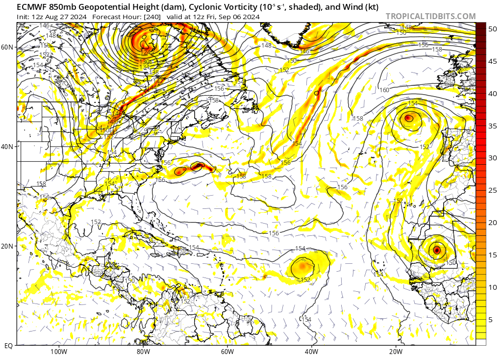
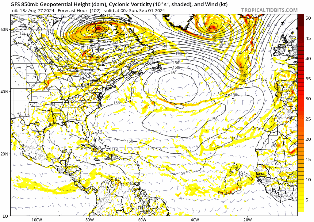
Chances are increasing that we may see a TC in the Eastern Atlantic from the wave that's about to splash down. The following operational model runs have either developed a TC, or shown great consolidation of vorticity at 240 hrs that could have developed just beyond the end of the run:
  • ECMWF: 12z 8/27, 0z 8/28
  • GFS: 12z 8/27, 6z 8/28
  • CMC: 0z 8/28
  • ICON: Every run since 0z 8/27
The exceptions are 18z and 0z GFS, but the former is due to some spurious vorticity, and the latter is because it somehow stretches the wave N-S too much. Either way, this wave already has much greater operational model support than the 0/20 AOI right off the bat. There's also healthy support from the ensembles: 0z EPS has 28 lows (55%), and 6z GEFS has 23 lows (74%, though not all are TCs).

The wave fully exits Africa in about 2-3 days, but consolidation and possible development seem to be around the 7-10 days time frame (except ICON). Models seem to agree on a quick recurve near 40W at the moment. Unfortunately, that also sends the wave into a wall of shear just north of MDR that's anomalous for this season*, so the system seems unlikely to be strong. That said, some ensemble members and 12z GFS show a strong system on the recurve, possibly because it managed to ride out the western end of the shear, so never say never.

* I know 16-day model runs are highly unreliable, but GFS and GEFS both show shear dropping off in the day 10-16 range, which makes me believe it's just temporary like a typhoon-induced TUTT.

Image

------------------------------------------------------

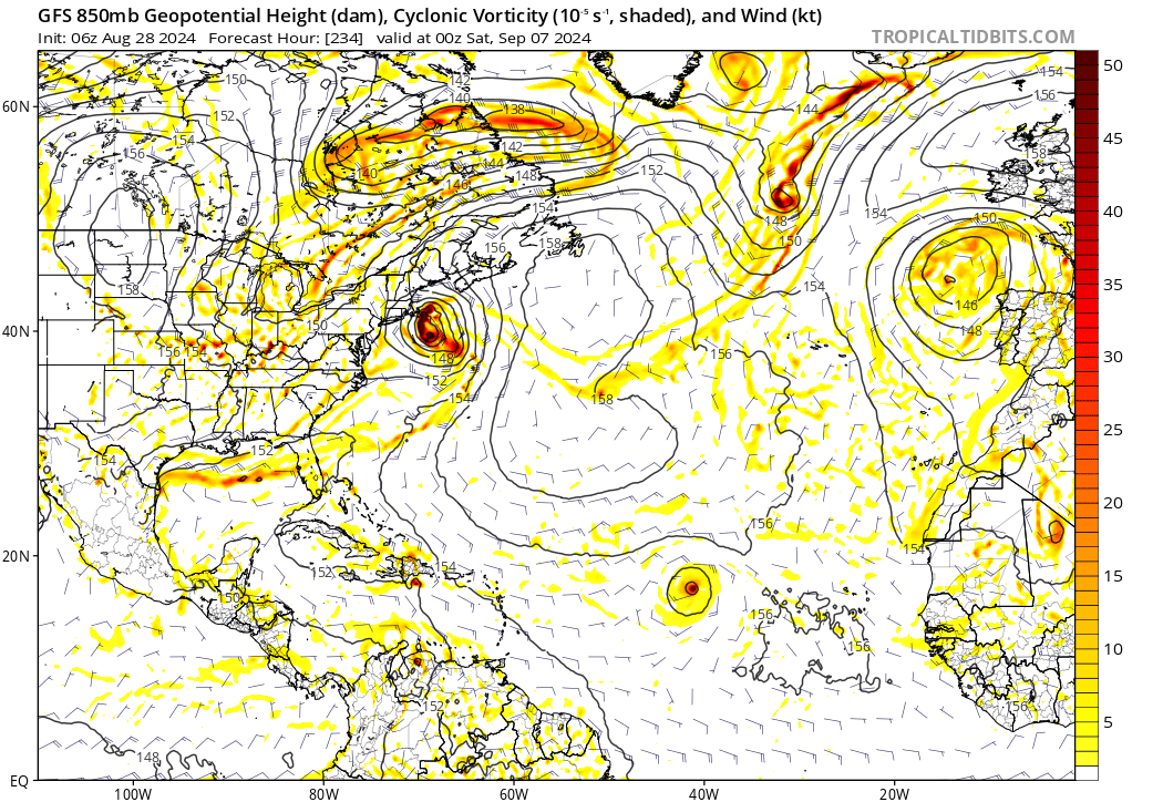
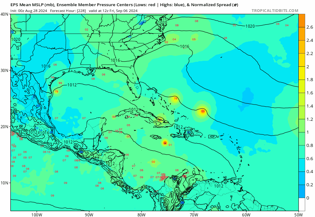
0z EPS also seems to show some members in the Gulf beyond Day 10, with 7 members even showing H or MH landfalls. The model doesn't seem nearly as biased in Caribbean and Gulf geneses as GFS-based ones. It's obviously too far out to be taken at face value, but I wonder if EPS is hinting at the possibility that the 0/20 wave may develop in the Caribbean or Gulf even if not in the MDR. That idea is not totally foreign: 0z ICON showed development in Eastern Caribbean, while CMC has hinted at a piece of organizing vorticity near the end of the run for a few runs (including today's 0z).

Image
1 likes   

TomballEd
Category 2
Category 2
Posts: 580
Age: 61
Joined: Wed Aug 16, 2023 4:52 pm
Location: Spring/Klein area, not Tomball

Re: 2024 Global Model Runs Discussion (Out thru day 16)

#1597 Postby TomballEd » Wed Aug 28, 2024 8:18 am

The AOI discussed in another thread still has some model support although it curves out to sea (before or after hitting the Islands). GEFS losing NW Gulf system, it does, down the road, get a rather strong member into the Gulf. (Some EPS support.) Op 6Z GFS does show some vorticity and enhanced moisture. Vort may develop over C. America/Yucatan, moisture surge may be what is left of the 7 day 20% (see other thread) AOI,

As Stratton noted, there is Euro ensembles support for the nearer term Gulf solution, or that is also still possible. EPS and GEFS have a mid-Atlantic system starting to develop in a week. Between the three areas with ensemble suggestions of development, at least 1 should develop. Earlier I though we might get to September 10th and 11th, season peak, without a NS, I think we'll have at least one NS before then.

imgur and Giphy blocked at work

EDIT- SEE POST ABOVE MINE FOR IMAGES
0 likes   

DunedinDave
Tropical Storm
Tropical Storm
Posts: 217
Joined: Fri Aug 25, 2023 10:31 am

Re: 2024 Global Model Runs Discussion (Out thru day 16)

#1598 Postby DunedinDave » Wed Aug 28, 2024 8:59 am

The fact that we are talking about the possibility of going into Sept 10 without a recent named storm is mind-blowing. The odds of no storm from mid Aug until Sep 10 was probably at like 50-1. It still may happen, but I am speechless as to how quiet it has been given the forecast. Somewhat happy because we got hit hard from Debby, but also somewhat disappointed because I do like following storms when they develop. After Sep 10, it can sometimes die down pretty fast as we’ve seen before with fronts coming down. Just crazy.
0 likes   

User avatar
wxman57
Moderator-Pro Met
Moderator-Pro Met
Posts: 22951
Age: 67
Joined: Sat Jun 21, 2003 8:06 pm
Location: Houston, TX (southwest)

Re: 2024 Global Model Runs Discussion (Out thru day 16)

#1599 Postby wxman57 » Wed Aug 28, 2024 9:13 am

I think we may have 1-2 named storms before Sept. 10th, but that's only 6-7 named storms at the midway point. ICON develops a frontal low off the TX coast next Tue-Wed. It has lows in the 60s and highs in the low 80s across Houston. Other models have mid 70s for lows to low to mid 90s for highs. I think it's unlikely a cold front will move into the Gulf next week.

GFS & Euro are developing something in the subtropical Atlantic that's now over Africa. Bermuda high is very weak and far east. Will be hard to get any developing storm into the Caribbean with the current pattern. Waves would track east, but likely with little or no convection. Could also see something develop off a front NE or E of Bermuda.

Instability across the MDR is quite low, similar to what we typically see in March or April. Quite an amazing pattern as we approach peak season. My coworker was arguing for only 10 named storms this year, but I only lowered our numbers to 18/8/4. Might be hard to reach 18 named storms, though. I figure 4-6 in September and maybe 3-4 in October. That's 15. Could see one or two in November. Let's hope they all stay out to sea.

http://www.ssd.noaa.gov/PS/TROP/TCFP/data/current/ts_al_tat_THDV.gif
0 likes   

DunedinDave
Tropical Storm
Tropical Storm
Posts: 217
Joined: Fri Aug 25, 2023 10:31 am

Re: 2024 Global Model Runs Discussion (Out thru day 16)

#1600 Postby DunedinDave » Wed Aug 28, 2024 9:29 am

wxman57 wrote:I think we may have 1-2 named storms before Sept. 10th, but that's only 6-7 named storms at the midway point. ICON develops a frontal low off the TX coast next Tue-Wed. It has lows in the 60s and highs in the low 80s across Houston. Other models have mid 70s for lows to low to mid 90s for highs. I think it's unlikely a cold front will move into the Gulf next week.

GFS & Euro are developing something in the subtropical Atlantic that's now over Africa. Bermuda high is very weak and far east. Will be hard to get any developing storm into the Caribbean with the current pattern. Waves would track east, but likely with little or no convection. Could also see something develop off a front NE or E of Bermuda.

Instability across the MDR is quite low, similar to what we typically see in March or April. Quite an amazing pattern as we approach peak season. My coworker was arguing for only 10 named storms this year, but I only lowered our numbers to 18/8/4. Might be hard to reach 18 named storms, though. I figure 4-6 in September and maybe 3-4 in October. That's 15. Could see one or two in November. Let's hope they all stay out to sea.

http://www.ssd.noaa.gov/PS/TROP/TCFP/data/current/ts_al_tat_THDV.gif


So I have a question. Let’s just say no storms develop between now and 9/10 and we get only a few after that. Did the Hurricane forecasters flat out miss the environmental conditions and have egg on their face or is this something that was a complete curveball that no one could have predicted? I’m just trying to wrap my head around all this doom and gloom forecasts from June surrounding the upcoming season and now we’re talking about “potentially” a relatively quiet year.

Also wanted to say thanks for all you do. I always enjoy your posts on here especially when things get busy.
0 likes   


Return to “Talkin' Tropics”

Who is online

Users browsing this forum: Google Adsense [Bot], Sciencerocks and 108 guests