EPAC: GILMA - Post-Tropical - Discussion

Moderator: S2k Moderators

Message
Author
User avatar
Yellow Evan
Professional-Met
Professional-Met
Posts: 16058
Age: 26
Joined: Fri Jul 15, 2011 12:48 pm
Location: Henderson, Nevada/Honolulu, HI
Contact:

Re: EPAC: GILMA - Hurricane - Discussion

#161 Postby Yellow Evan » Mon Aug 26, 2024 1:22 pm

Kingarabian wrote:
Teban54 wrote:Is Gilma still intensifying???

https://i.postimg.cc/2jFPzB8h/goes18-ir-07-E-202408261125.gif

If Eye temp becomes positive, it's an automatic Cat.3 on Dvorak since the CDO is cold enough and there is no constraints.


9C, not positive.
1 likes   

User avatar
Yellow Evan
Professional-Met
Professional-Met
Posts: 16058
Age: 26
Joined: Fri Jul 15, 2011 12:48 pm
Location: Henderson, Nevada/Honolulu, HI
Contact:

Re: EPAC: GILMA - Hurricane - Discussion

#162 Postby Yellow Evan » Mon Aug 26, 2024 1:23 pm

TXPZ28 KNES 261812
TCSENP

A. 07E (GILMA)
B. 26/1801Z
C. 18.3N
D. 136.8W
E. ONE/GOES-W
F. T5.5/5.5
G. IR/EIR
H. REMARKS...WMG EYE IS EMBEDDED IN AND SURROUNDED BY LG RESULTING IN
A DT OF 5.5 AFTER ADDING 0.5 FOR THE EYE ADJUSTMENT. THE MET AND PT ARE
ALSO 5.5. THE FT IS BASED ON THE DT.
I. ADDL POSITIONS
NIL

...TURK
0 likes   

User avatar
aspen
Category 5
Category 5
Posts: 8812
Joined: Sat Oct 12, 2019 7:10 pm
Location: Connecticut, USA

Re: EPAC: GILMA - Hurricane - Discussion

#163 Postby aspen » Mon Aug 26, 2024 1:23 pm

This looks like it’s around 105kt, maybe even 110kt, but I’m half expecting the NHC to go with 95kt at 5pm. Par for the course for Gilma lol. Impressive that it finds every opportunity to try intensifying again when everyone thinks it’s done for.
1 likes   
Irene '11 Sandy '12 Hermine '16 5/15/2018 Derecho Fay '20 Isaias '20 Elsa '21 Henri '21 Ida '21

I am only a meteorology enthusiast who knows a decent amount about tropical cyclones. Look to the professional mets, the NHC, or your local weather office for the best information.

User avatar
Hurricane2022
Category 5
Category 5
Posts: 1496
Joined: Tue Aug 23, 2022 11:38 pm
Location: Araçatuba, Brazil

Re: EPAC: GILMA - Hurricane - Discussion

#164 Postby Hurricane2022 » Mon Aug 26, 2024 1:24 pm

Yellow Evan wrote:
Kingarabian wrote:
Teban54 wrote:Is Gilma still intensifying???

https://i.postimg.cc/2jFPzB8h/goes18-ir-07-E-202408261125.gif

If Eye temp becomes positive, it's an automatic Cat.3 on Dvorak since the CDO is cold enough and there is no constraints.


9C, not positive.

Anyway, the eye is already at 12C. It's time for an (another) upgrade, folks. 8-)
1 likes   
Sorry for the bad English sometimes...!
For reliable and detailed information for any meteorological phenomenon, please consult the National Hurricane Center, Joint Typhoon Warning Center , or your local Meteo Center.

--------

Una cvm Christo, pro Christo, et in Christo. Sit nomen Domini benedictvm.

User avatar
ElectricStorm
Category 5
Category 5
Posts: 5017
Age: 24
Joined: Tue Aug 13, 2019 11:23 pm
Location: Skiatook, OK / Norman, OK

Re: EPAC: GILMA - Hurricane - Discussion

#165 Postby ElectricStorm » Mon Aug 26, 2024 1:52 pm

:lol:
07E GILMA 240826 1800 18.3N 136.9W EPAC 95 968
0 likes   
I am in no way a professional. Take what I say with a grain of salt as I could be totally wrong. Please refer to the NHC, NWS, or SPC for official information.

Boomer Sooner!

User avatar
aspen
Category 5
Category 5
Posts: 8812
Joined: Sat Oct 12, 2019 7:10 pm
Location: Connecticut, USA

Re: EPAC: GILMA - Hurricane - Discussion

#166 Postby aspen » Mon Aug 26, 2024 2:21 pm

ElectricStorm wrote::lol:
07E GILMA 240826 1800 18.3N 136.9W EPAC 95 968

Called it.

What is it with the NHC being so hyper-conservative with Gilma? I know they err on the side of caution when they don’t have hard data, but come on. This got a T5.5 and is clearly more than a high-end 2. That’s now 3 consecutive peaks where they’ve under-estimated Gilma.
2 likes   
Irene '11 Sandy '12 Hermine '16 5/15/2018 Derecho Fay '20 Isaias '20 Elsa '21 Henri '21 Ida '21

I am only a meteorology enthusiast who knows a decent amount about tropical cyclones. Look to the professional mets, the NHC, or your local weather office for the best information.

User avatar
ElectricStorm
Category 5
Category 5
Posts: 5017
Age: 24
Joined: Tue Aug 13, 2019 11:23 pm
Location: Skiatook, OK / Norman, OK

Re: EPAC: GILMA - Hurricane - Discussion

#167 Postby ElectricStorm » Mon Aug 26, 2024 2:23 pm

aspen wrote:
ElectricStorm wrote::lol:
07E GILMA 240826 1800 18.3N 136.9W EPAC 95 968

Called it.

What is it with the NHC being so hyper-conservative with Gilma? I know they err on the side of caution when they don’t have hard data, but come on. This got a T5.5 and is clearly more than a high-end 2. That’s now 3 consecutive peaks where they’ve under-estimated Gilma.

And Ernesto's second peak. Definitely odd from them
2 likes   
I am in no way a professional. Take what I say with a grain of salt as I could be totally wrong. Please refer to the NHC, NWS, or SPC for official information.

Boomer Sooner!

User avatar
aspen
Category 5
Category 5
Posts: 8812
Joined: Sat Oct 12, 2019 7:10 pm
Location: Connecticut, USA

Re: EPAC: GILMA - Hurricane - Discussion

#168 Postby aspen » Mon Aug 26, 2024 2:40 pm

ElectricStorm wrote:
aspen wrote:
ElectricStorm wrote::lol:
07E GILMA 240826 1800 18.3N 136.9W EPAC 95 968

Called it.

What is it with the NHC being so hyper-conservative with Gilma? I know they err on the side of caution when they don’t have hard data, but come on. This got a T5.5 and is clearly more than a high-end 2. That’s now 3 consecutive peaks where they’ve under-estimated Gilma.

And Ernesto's second peak. Definitely odd from them

Right, almost forgot about that.

Part of the reason seems to be satellite estimates falling below the likely intensity, like with Ernesto (I don’t recall any getting close to MH intensity despite it looking like 90-100 kt). I remember ADT was pretty bad last year, constantly missing the eye on all but the largest systems and skewing estimates. SATCON always seems to lowball. Many bad manual fixes don’t help either. So even if it looks like a major, it’s hard to officially say that if the estimates don’t support it. But when the NHC is choosing to go below those estimates, it doesn’t make much sense.

I know they’re the experts and they have decades of experience (which I certainly don’t have lol), but man some of their calls are rough (let’s not forget last January’s borderline hurricane getting called a 20/20 AOI). Even though these under-estimated EPac storms usually don’t pose a threat to land and therefore there’s no a danger in underselling the intensity of a system, it’s still useful for completionism’s sake and having an accurate record of storms to provide a good operational intensity estimate.
1 likes   
Irene '11 Sandy '12 Hermine '16 5/15/2018 Derecho Fay '20 Isaias '20 Elsa '21 Henri '21 Ida '21

I am only a meteorology enthusiast who knows a decent amount about tropical cyclones. Look to the professional mets, the NHC, or your local weather office for the best information.

User avatar
Teban54
Category 5
Category 5
Posts: 3168
Joined: Sat May 19, 2018 1:19 pm

Re: EPAC: GILMA - Hurricane - Discussion

#169 Postby Teban54 » Mon Aug 26, 2024 3:55 pm

:double:
Image
5 likes   

User avatar
cycloneye
Admin
Admin
Posts: 143863
Age: 68
Joined: Thu Oct 10, 2002 10:54 am
Location: San Juan, Puerto Rico

Re: EPAC: GILMA - Hurricane - Discussion

#170 Postby cycloneye » Mon Aug 26, 2024 3:58 pm

Hurricane Gilma Discussion Number 35
NWS National Hurricane Center Miami FL EP072024
1100 AM HST Mon Aug 26 2024

Gilma's eye continues to become more symmetric with a warming eye
and impressive convection surrounding the eye. Objective intensity
estimates from UW-CIMSS have been generally increasing over the last
several hours, ranging from 85 to 96 kt. Subjective Dvorak
estimates are T-5.0/90 kt from TAFB and T-5.5/102 kt from SAB. The
initial intensity is set to 95 kt based on a blend of the subjective
estimates.

Other than the stronger initial intensity, there is no change to the
environmental conditions that Gilma is expected to traverse through
the forecast period. Sea surface temperatures (SSTs) and vertical
wind shear conditions have been favorable enough for Gilma to
strengthen over the past 12 h. By tonight, westerly vertical wind
shear is predicted to increase to 15 to 20 kt, which should put a
halt to any additional strengthening, and likely induce a slow
weakening trend. Beyond 24 h, Gilma is forecast to reach slightly
cooler SSTs, which should cause a faster rate of weakening in the
24-48 h time period. These factors, combined with the relatively
dry and stable airmass that Gilma will continue to be embedded in,
is likely to cause the cyclone to lose its convection and become a
remnant low in 3 to 4 days, as suggested by the GFS and ECMWF
simulated satellite imagery. The global models then show the
remnant low gradually weakening through day 5, possibly opening up
into a trough around that time. The new NHC intensity forecast is
higher than the previous forecast for the first 24 h due to the
stronger initial intensity and relatively unchanged after that, and
lies close to the middle of the guidance envelope.

The initial motion is estimated to be westward, or 280/7 kt. The
track guidance is faster this cycle, following the global model
solutions. The new NHC forecast is similar to the previous forecast
through 36 h, then shows a faster motion toward the west-northwest,
though not as fast as the latest consensus track models. The cross
track spread in the guidance remains very low, and the NHC forecast
is essentially on top of the consensus models.


FORECAST POSITIONS AND MAX WINDS

INIT 26/2100Z 18.4N 137.4W 95 KT 110 MPH
12H 27/0600Z 18.5N 138.8W 90 KT 105 MPH
24H 27/1800Z 18.7N 140.9W 75 KT 85 MPH
36H 28/0600Z 18.9N 143.1W 60 KT 70 MPH
48H 28/1800Z 19.4N 145.3W 50 KT 60 MPH
60H 29/0600Z 19.9N 147.4W 45 KT 50 MPH
72H 29/1800Z 20.3N 149.5W 40 KT 45 MPH
96H 30/1800Z 21.2N 154.0W 30 KT 35 MPH...POST-TROP/REMNT LOW
120H 31/1800Z 22.8N 158.5W 25 KT 30 MPH...POST-TROP/REMNT LOW

$$
Forecaster Hagen/Pasch
0 likes   
Visit the Caribbean-Central America Weather Thread where you can find at first post web cams,radars
and observations from Caribbean basin members Click Here

User avatar
Kingarabian
S2K Supporter
S2K Supporter
Posts: 15827
Joined: Sat Aug 08, 2009 3:06 am
Location: Honolulu, Hawaii

Re: EPAC: GILMA - Hurricane - Discussion

#171 Postby Kingarabian » Mon Aug 26, 2024 7:43 pm

SAB remains at 5.5.
0 likes   
RIP Kobe Bryant

User avatar
Kingarabian
S2K Supporter
S2K Supporter
Posts: 15827
Joined: Sat Aug 08, 2009 3:06 am
Location: Honolulu, Hawaii

Re: EPAC: GILMA - Hurricane - Discussion

#172 Postby Kingarabian » Mon Aug 26, 2024 10:44 pm

Models have done really bad with Gilma's intensity.
Image
0 likes   
RIP Kobe Bryant

User avatar
cycloneye
Admin
Admin
Posts: 143863
Age: 68
Joined: Thu Oct 10, 2002 10:54 am
Location: San Juan, Puerto Rico

Re: EPAC: GILMA - Hurricane - Discussion

#173 Postby cycloneye » Mon Aug 26, 2024 10:46 pm

Hurricane Gilma Discussion Number 36
NWS National Hurricane Center Miami FL EP072024
500 PM HST Mon Aug 26 2024

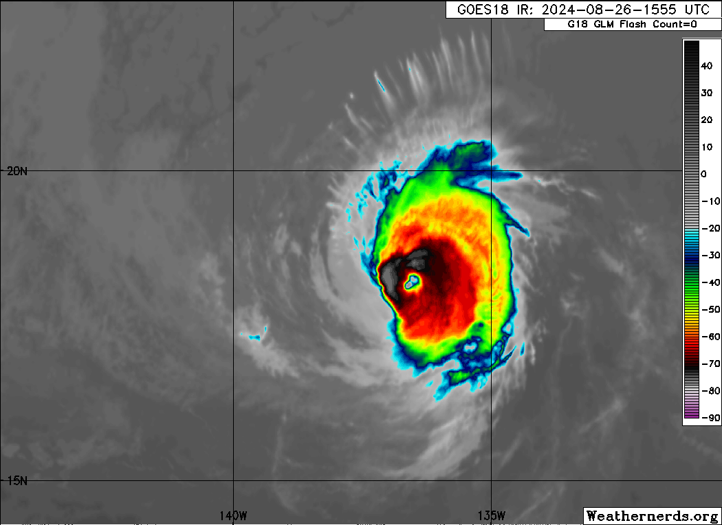
Gilma remains a resilient hurricane over the far western portion of
the Eastern Pacific. Its eye is distinct and surrounded by a healthy
ring of cold -60 to -70C cloud tops. Both a GMI and AMSR2 microwave
pass received after the prior advisory also highlight Gilma's
well-organized structure, primarily in the form of a single closed
eyewall. However, the eyewall does appear to be weaker on its
southern side, which might be a harbinger of increasing westerly
vertical wind shear finally beginning to impact the inner-core
structure. In the meantime, subjective and objective intensity
estimates are largely unchanged from earlier this afternoon, and the
initial intensity is held at 95 kt for this advisory.

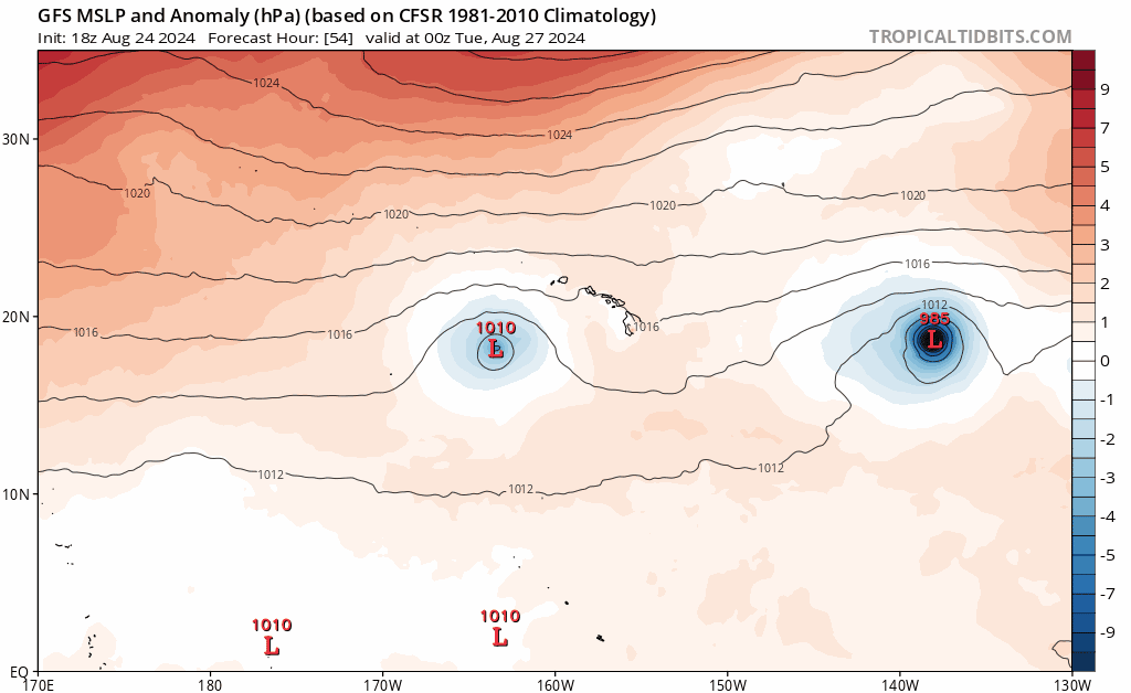
Gilma continues on a just north of due westward track, though a
little faster than earlier at 280/10 kt. A prominent subtropical
ridge to its north should continue to steer the hurricane generally
westward to west-northwestward with a gradual increase in forward
motion over the next several days. On this track, Gilma should enter
the Central Pacific basin by tomorrow morning. The deep-layer
ridging does weaken towards the end of the forecast period, but
Gilma will also likely become more vertically shallow at that time.
The track guidance this cycle once again is a bit faster than the
prior one, and the NHC track forecast is also a little faster than
the previous one, blending the consensus aids TCVE and HCCA with the
prior track forecast.

While Gilma has defied the odds and remained stronger than
forecasted over the past couple of days, there is evidence that
westerly vertical wind shear is beginning to impinge on the
hurricane. SHIPS guidance shows this shear gradually increasing as
Gilma also traverses a very dry mid-level environment and only
marginal 25-26 C sea-surface temperatures. Assuming this dry air is
ultimately entrained into its inner core, weakening should begin
soon. After 48-60 h, the EC-SHIPS shows the shear increasing to more
than 30 kt, which will likely continue this weakening trend even as
Gilma begins to move over warmer waters again. The NHC intensity
forecast is similar to the prior advisory, just a little on the high
side of the intensity consensus early on. Both the GFS and ECMWF
suggest the system will cease to produce organized convection after
72 h, with remnant low status forecast after that time, and final
dissipation by 120 h.


FORECAST POSITIONS AND MAX WINDS

INIT 27/0300Z 18.5N 138.3W 95 KT 110 MPH
12H 27/1200Z 18.6N 140.0W 85 KT 100 MPH
24H 28/0000Z 18.8N 142.2W 70 KT 80 MPH
36H 28/1200Z 19.1N 144.4W 55 KT 65 MPH
48H 29/0000Z 19.6N 146.6W 50 KT 60 MPH
60H 29/1200Z 20.1N 148.7W 45 KT 50 MPH
72H 30/0000Z 20.5N 151.0W 35 KT 40 MPH
96H 31/0000Z 21.7N 155.5W 30 KT 35 MPH...POST-TROP/REMNT LOW
120H 01/0000Z...DISSIPATED

$$
Forecaster Papin
0 likes   
Visit the Caribbean-Central America Weather Thread where you can find at first post web cams,radars
and observations from Caribbean basin members Click Here

User avatar
aspen
Category 5
Category 5
Posts: 8812
Joined: Sat Oct 12, 2019 7:10 pm
Location: Connecticut, USA

Re: EPAC: GILMA - Hurricane - Discussion

#174 Postby aspen » Tue Aug 27, 2024 4:51 am

Impressive. All 3 peaks were under-estimated. I don’t recall another storm like this in the EPac or Atlantic.

Also how the heck does any estimate support 90 kt for this lol. Gilma looks like a minimal Cat 1 at best right now. Now it should finally be weakening for good.
1 likes   
Irene '11 Sandy '12 Hermine '16 5/15/2018 Derecho Fay '20 Isaias '20 Elsa '21 Henri '21 Ida '21

I am only a meteorology enthusiast who knows a decent amount about tropical cyclones. Look to the professional mets, the NHC, or your local weather office for the best information.

User avatar
wxman57
Moderator-Pro Met
Moderator-Pro Met
Posts: 22950
Age: 67
Joined: Sat Jun 21, 2003 8:06 pm
Location: Houston, TX (southwest)

Re: EPAC: GILMA - Hurricane - Discussion

#175 Postby wxman57 » Tue Aug 27, 2024 7:34 am

aspen wrote:Impressive. All 3 peaks were under-estimated. I don’t recall another storm like this in the EPac or Atlantic.

Also how the heck does any estimate support 90 kt for this lol. Gilma looks like a minimal Cat 1 at best right now. Now it should finally be weakening for good.


Agree - exposed center with a single squall about 40 miles to the east does not appear to be a 90 kt hurricane, just 5 kt s weaker than yesterday.
0 likes   

Subtrop
Category 2
Category 2
Posts: 654
Joined: Sun Feb 21, 2021 9:45 pm

Re: CPAC: GILMA - Hurricane - Discussion

#176 Postby Subtrop » Tue Aug 27, 2024 7:41 am

EP, 07, 2024082712, , BEST, 0, 184N, 1401W, 75, 983, HU,
0 likes   

User avatar
wxman57
Moderator-Pro Met
Moderator-Pro Met
Posts: 22950
Age: 67
Joined: Sat Jun 21, 2003 8:06 pm
Location: Houston, TX (southwest)

Re: EPAC: GILMA - Hurricane - Discussion

#177 Postby wxman57 » Tue Aug 27, 2024 8:06 am

Somehow, this loop doesn't scream "Hurricane!" to me. Looks well on its way to being a remnant low.

http://wxman57.com/images/Gilma2.gif

Image
0 likes   

User avatar
cycloneye
Admin
Admin
Posts: 143863
Age: 68
Joined: Thu Oct 10, 2002 10:54 am
Location: San Juan, Puerto Rico

Re: EPAC: GILMA - Tropical Storm - Discussion

#178 Postby cycloneye » Tue Aug 27, 2024 3:47 pm

Tropical Storm Gilma Discussion Number 39
NWS Central Pacific Hurricane Center Honolulu HI EP072024
Issued by NWS National Hurricane Center Miami FL
1100 AM HST Tue Aug 27 2024

The low-level center of Gilma continues to run out ahead of the deep
convection. The center is now located more than 60 n mi outside of
the convection, suggesting that Gilma is continuing to weaken
rapidly. The latest subjective Dvorak intensity estimates from
SAB, JTWC, and PHFO range from 45 to 77 kt. Recent objective
intensity estimates from UW-CIMSS range from 41 to 51 kt. The
initial intensity is brought down to 55 kt for this advisory, and
this could be generous. Gilma has weakened by 40 kt over the past
15 h or so.

Gilma should continue to weaken over the next 36 h as it remains
located within an environment of 15 to 20 kt of westerly wind shear,
dry air, and within sea-surface temperatures (SSTs) of 25 to 26C.
The official intensity forecast has been reduced significantly
during the short term due to the lower initial intensity, and lies
at the high end of the intensity guidance for the first 24 h. In
about 48 h, Gilma should move into an area of even stronger westerly
wind shear, which will lead to any remaining convection being
stripped away. Gilma is forecast to weaken to a remnant low by
Thursday night, but it's possible the cyclone could become a remnant
low sooner than that. The global models are forecasting the
remnant low to open up into a trough in about 4 days, and the
official forecast calls for dissipation at that time.

Gilma continues moving due westward and has sped up a bit, with an
initial motion estimate of 270/13 kt. A ridge north of Gilma will
continue to steer the cyclone westward to west-northwestward. The
official forecast has been adjusted slightly to the south and a bit
faster than the previous prediction, and is in best agreement with
the TCVE consensus aid.


FORECAST POSITIONS AND MAX WINDS

INIT 27/2100Z 18.5N 142.1W 55 KT 65 MPH
12H 28/0600Z 18.6N 143.8W 45 KT 50 MPH
24H 28/1800Z 19.0N 146.0W 40 KT 45 MPH
36H 29/0600Z 19.4N 148.2W 35 KT 40 MPH
48H 29/1800Z 19.9N 150.5W 30 KT 35 MPH
60H 30/0600Z 20.4N 152.8W 30 KT 35 MPH...POST-TROP/REMNT LOW
72H 30/1800Z 21.0N 155.1W 25 KT 30 MPH...POST-TROP/REMNT LOW
96H 31/1800Z...DISSIPATED

$$
Forecaster Hagen/Pasch
0 likes   
Visit the Caribbean-Central America Weather Thread where you can find at first post web cams,radars
and observations from Caribbean basin members Click Here

User avatar
Iceresistance
Category 5
Category 5
Posts: 9279
Age: 21
Joined: Sat Oct 10, 2020 9:45 am
Location: Tecumseh, OK/Norman, OK

Re: EPAC: GILMA - Tropical Storm - Discussion

#179 Postby Iceresistance » Wed Aug 28, 2024 11:10 am

Tropical Storm Gilma Discussion Number 42
NWS Central Pacific Hurricane Center Honolulu HI EP072024
500 AM HST Wed Aug 28 2024

ProxyVis satellite imagery shows Gilma's exposed low-level
circulation center tracking just north of due west. Limited
deep convection is forming a weak curved band north and northeast
of the center, where an earlier ASCAT pass detected winds near 40
kt. This data, and a blend of the subjective Dvorak estimates from
PHFO, JTWC and SAB, supports lowering the initial intensity estimate
to 40 kt.

The initial motion estimate is 280/12 kt. A low-level ridge north
of Gilma will continue to steer the shallow cyclone westward to
west-northwestward until it dissipates near Kauai this weekend.
There has been little change in the track guidance, and the new
forecast track is similar to the previous track, and lies close to
HCCA and FSSE guidance.

Gilma is expected to gradually degenerate to a remnant low as it
passes close to the Hawaiian Islands Friday into Saturday. Guidance
indicates the strong westerly vertical wind shear currently
impacting Gilma will briefly ease later today as a passing trough
aloft lifts north, slowing the recent rapid weakening trend. Another
trough aloft approaching from the west will bring even stronger
vertical wind shear Thursday and Friday, eventually leading to
dissipation. The new intensity forecast follows trends presented by
the intensity consensus IVCN and SHIPS.


FORECAST POSITIONS AND MAX WINDS

INIT 28/1500Z 18.8N 145.7W 40 KT 45 MPH
12H 29/0000Z 19.1N 147.5W 40 KT 45 MPH
24H 29/1200Z 19.6N 149.8W 35 KT 40 MPH
36H 30/0000Z 20.1N 152.0W 35 KT 40 MPH
48H 30/1200Z 20.7N 154.4W 30 KT 35 MPH...POST-TROP/REMNT LOW
60H 31/0000Z 21.4N 156.8W 30 KT 35 MPH...POST-TROP/REMNT LOW
72H 31/1200Z 22.3N 159.2W 25 KT 30 MPH...POST-TROP/REMNT LOW
96H 01/1200Z...DISSIPATED

$$
Forecaster Birchard
0 likes   
Bill 2015 & Beta 2020

Winter 2020-2021 :cold:

All observations are in Tecumseh, OK unless otherwise noted.

Winter posts are focused mainly for Oklahoma & Texas.

Take any of my forecasts with a grain of salt, refer to the NWS, SPC, and NHC for official information

Never say Never with weather! Because ANYTHING is possible!


Return to “2024”

Who is online

Users browsing this forum: No registered users and 5 guests