WPAC: SHANSHAN - Post-Tropical

Moderator: S2k Moderators

Message
Author
User avatar
doomhaMwx
Category 5
Category 5
Posts: 2454
Age: 26
Joined: Tue Apr 18, 2017 4:01 am
Location: Baguio/Benguet, Philippines
Contact:

Re: WPAC: SHANSHAN - Typhoon

#41 Postby doomhaMwx » Wed Aug 28, 2024 1:23 am

Nakanoshima entered the edge of the eye. Min SLP reported by the lighthouse on the island (blue star) is 945 mb at 04Z-05Z. Winds are lackluster though (around minimal typhoon strength), which isn't surprising given how eroded half of the eyewall is.

Image
Image
Image
0 likes   

User avatar
cycloneye
Admin
Admin
Posts: 143863
Age: 68
Joined: Thu Oct 10, 2002 10:54 am
Location: San Juan, Puerto Rico

Re: WPAC: SHANSHAN - Typhoon

#42 Postby cycloneye » Wed Aug 28, 2024 8:24 am

0 likes   
Visit the Caribbean-Central America Weather Thread where you can find at first post web cams,radars
and observations from Caribbean basin members Click Here

User avatar
Hayabusa
Category 5
Category 5
Posts: 4244
Joined: Sun Sep 16, 2018 1:05 pm

Re: WPAC: SHANSHAN - Typhoon

#43 Postby Hayabusa » Wed Aug 28, 2024 8:57 am

06Z HFAS restrengthens at the end of the run
Image
Image
GEFS 06Z
Image
While EPS 06Z most members are NE track only one outlier
0 likes   
ヤンデレ女が寝取られるているのを見たい!!!
ECMWF ensemble NWPAC plots: https://ecmwfensnwpac.imgbb.com/
Multimodel NWPAC plots: https://multimodelnwpac.imgbb.com/
GFS Ensemble NWPAC plots (16 & 35 day forecast): https://gefsnwpac.imgbb.com/
Plots updated automatically

User avatar
cycloneye
Admin
Admin
Posts: 143863
Age: 68
Joined: Thu Oct 10, 2002 10:54 am
Location: San Juan, Puerto Rico

Re: WPAC: SHANSHAN - Typhoon

#44 Postby cycloneye » Wed Aug 28, 2024 12:36 pm

1 likes   
Visit the Caribbean-Central America Weather Thread where you can find at first post web cams,radars
and observations from Caribbean basin members Click Here

User avatar
doomhaMwx
Category 5
Category 5
Posts: 2454
Age: 26
Joined: Tue Apr 18, 2017 4:01 am
Location: Baguio/Benguet, Philippines
Contact:

Re: WPAC: SHANSHAN - Typhoon

#45 Postby doomhaMwx » Wed Aug 28, 2024 5:54 pm

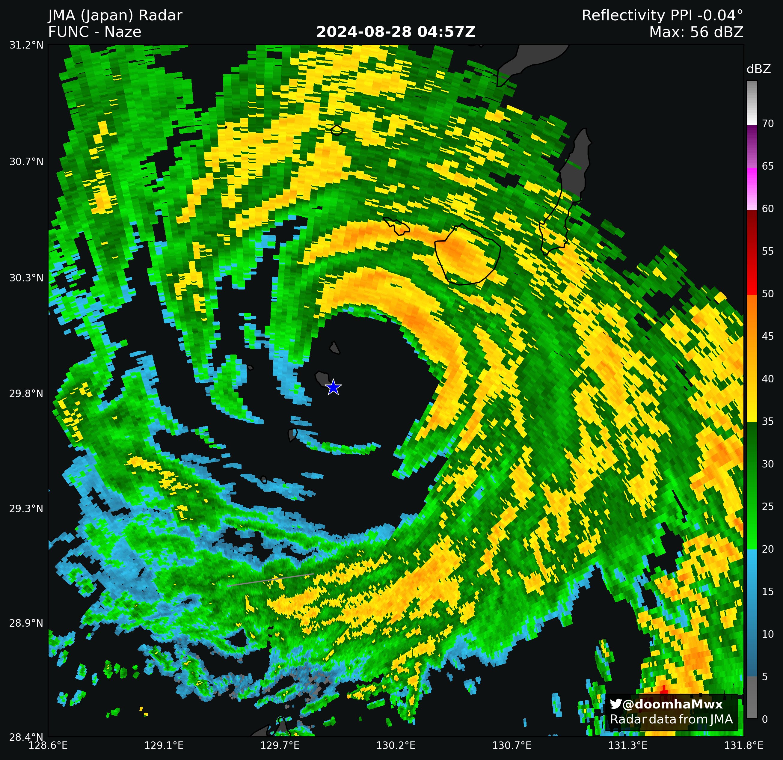
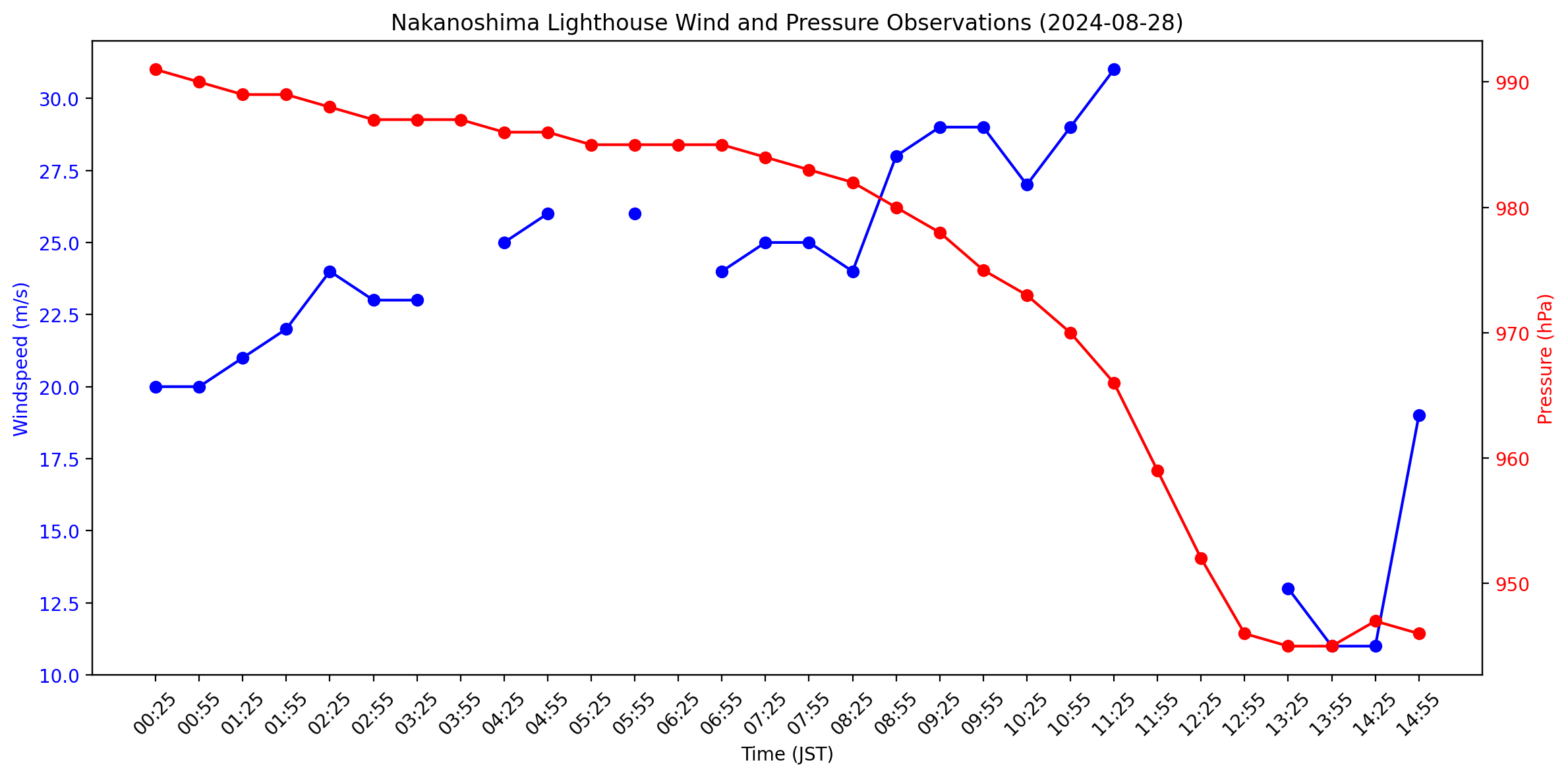
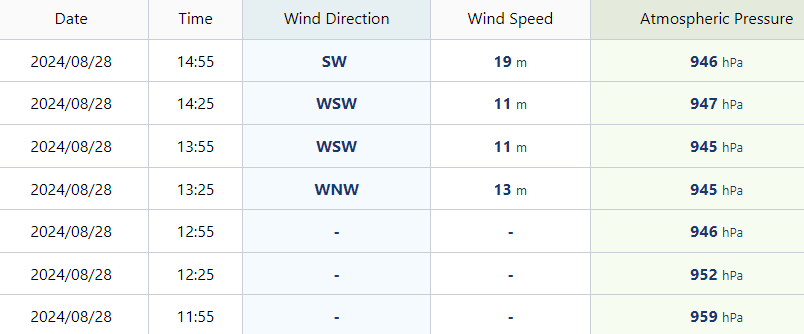
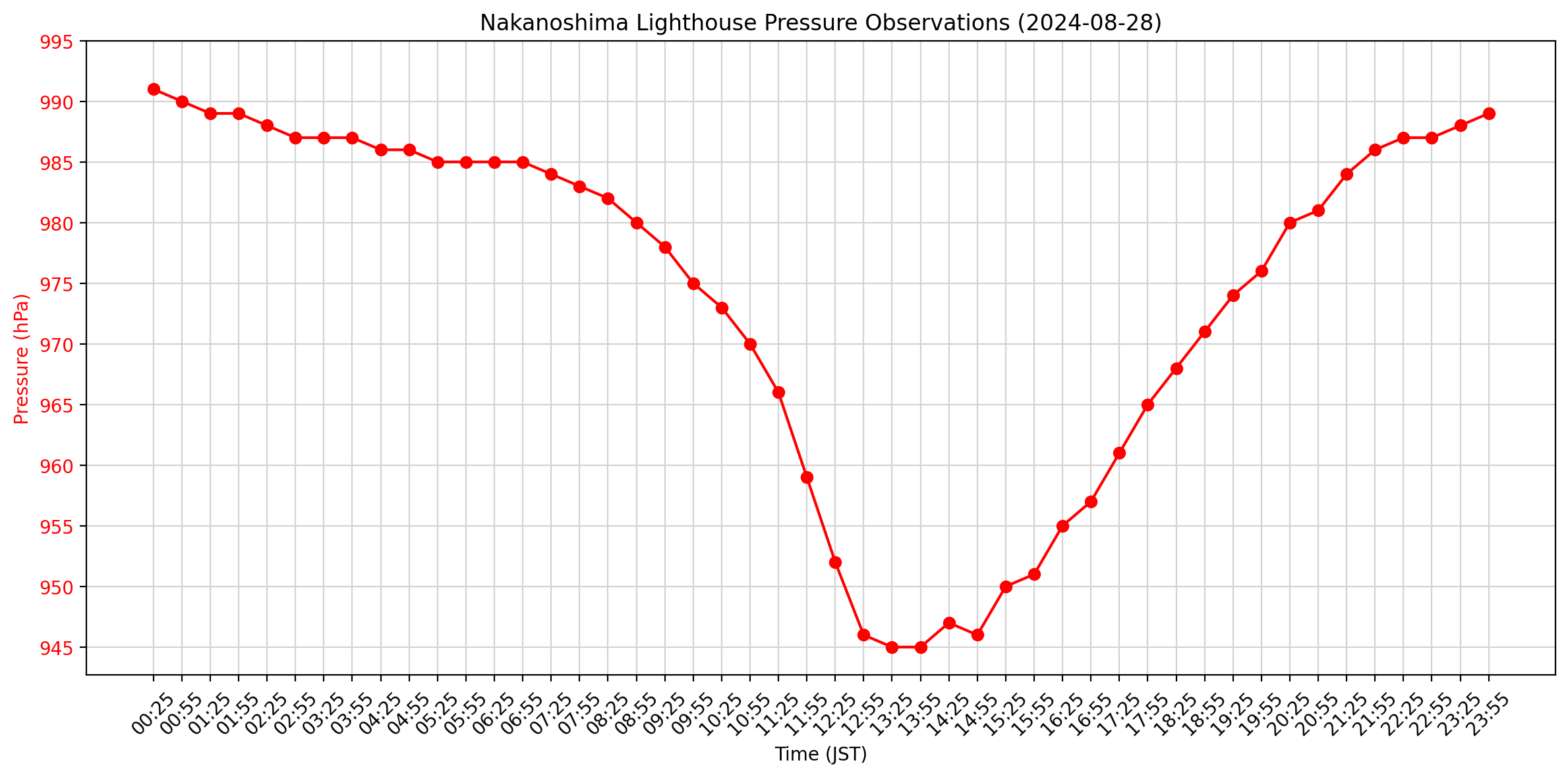
doomhaMwx wrote:Nakanoshima entered the edge of the eye. Min SLP reported by the lighthouse on the island (blue star) is 945 mb at 04Z-05Z. Winds are lackluster though (around minimal typhoon strength), which isn't surprising given how eroded half of the eyewall is.

https://pbs.twimg.com/media/GWDDYUsWIAAH0SZ?format=jpg&name=4096x4096
https://pbs.twimg.com/media/GWDDbLTWQAAGFA9?format=png&name=4096x4096
https://pbs.twimg.com/media/GWDDdtJXEAACh2Z?format=png&name=900x900

Full pressure trace from Nakanoshima

Image
0 likes   

underthwx
Category 5
Category 5
Posts: 2351
Joined: Sat Jul 30, 2011 2:14 pm
Location: Brazoria County Texas

Re: WPAC: SHANSHAN - Typhoon

#46 Postby underthwx » Thu Aug 29, 2024 9:40 am

Hayabusa wrote:
underthwx wrote:
Hayabusa wrote:GFS 06Z similar scenario but longer timespan and more north, if this really happens Shanshan has yet to peak and it would be a big ACE maker...
https://i.imgur.com/KRWRHSr.png

Wassup Hayabusa?....hope all is well there my friend...gonna be seeing yall soon!....so...my questikn....what are the odds of this cyclone making the loop around yall mention?...thanks bro..

It's hard to say 12Z GFS remains the same scenario while Euro still recurving but seems to be trending on a slower NE track.
And also latest 12Z Euro ensemble is latching on to the GFS operational solution, we'll see if the operational Euro caves to the GFS. As a TC watcher the GFS solution would be very interesting to watch than plain old recurvature.
https://i.imgur.com/oQyuK93.png

Thankyou Hayabusa for the update!...
0 likes   

User avatar
Hayabusa
Category 5
Category 5
Posts: 4244
Joined: Sun Sep 16, 2018 1:05 pm

Re: WPAC: SHANSHAN - Typhoon

#47 Postby Hayabusa » Thu Aug 29, 2024 5:09 pm

underthwx wrote:
Hayabusa wrote:
underthwx wrote:Wassup Hayabusa?....hope all is well there my friend...gonna be seeing yall soon!....so...my questikn....what are the odds of this cyclone making the loop around yall mention?...thanks bro..

It's hard to say 12Z GFS remains the same scenario while Euro still recurving but seems to be trending on a slower NE track.
And also latest 12Z Euro ensemble is latching on to the GFS operational solution, we'll see if the operational Euro caves to the GFS. As a TC watcher the GFS solution would be very interesting to watch than plain old recurvature.
https://i.imgur.com/oQyuK93.png

Thankyou Hayabusa for the update!...

Now current official forecasts shows dissipation scenario while tracking NE slowly over Japan...
0 likes   
ヤンデレ女が寝取られるているのを見たい!!!
ECMWF ensemble NWPAC plots: https://ecmwfensnwpac.imgbb.com/
Multimodel NWPAC plots: https://multimodelnwpac.imgbb.com/
GFS Ensemble NWPAC plots (16 & 35 day forecast): https://gefsnwpac.imgbb.com/
Plots updated automatically


Return to “2024”

Who is online

Users browsing this forum: No registered users and 10 guests