Tropical Wave in Bay of Campeche (Is Invest 91L)
Moderator: S2k Moderators
Forum rules

The posts in this forum are NOT official forecasts and should not be used as such. They are just the opinion of the poster and may or may not be backed by sound meteorological data. They are NOT endorsed by any professional institution or STORM2K. For official information, please refer to products from the National Hurricane Center and National Weather Service.
-
Stratton23
- Category 5

- Posts: 3477
- Joined: Fri Jul 21, 2023 10:59 pm
- Location: Katy, Tx
Re: Disturbed weather in Central Atlantic (0/20)
And just like that the 12z models are why the NHC never changed their percentage, back with development again
1 likes
-
toad strangler

- S2K Supporter

- Posts: 4546
- Joined: Sun Jul 28, 2013 3:09 pm
- Location: Earth
- Contact:
Re: Disturbed weather in Central Atlantic (0/20)
Stratton23 wrote:And just like that the 12z models are why the NHC never changed their percentage, back with development again
12z GFS OP shows disorganized vorticity in the Greater Antilles at 10 days
12z CMC OP shows quite the hurricane off the far SE US Coast
The seedling does look like it's from the NHC lemon
1 likes
My Weather Station
https://www.wunderground.com/dashboard/pws/KFLPORTS603
https://www.wunderground.com/dashboard/pws/KFLPORTS603
-
WeatherBoy2000
- Category 1

- Posts: 459
- Joined: Mon Apr 10, 2023 9:29 am
Re: Disturbed weather in Central Atlantic (0/20)
Stratton23 wrote:And just like that the 12z models are why the NHC never changed their percentage, back with development again
The 06z eps is decidedly more bullish compared to the midnight run in the short term as well.
0 likes
-
Category5Kaiju

- Category 5
- Posts: 4322
- Joined: Thu Dec 24, 2020 12:45 pm
- Location: Seattle and Phoenix
Re: Disturbed weather in Central Atlantic (0/20)
Yeah, I think it was wise for the NHC to keep the lemon. I really have a feeling that some of these models were struggling with the monsoonal trough, but the initial “aha” that, especially the Euro ensembles, had may have indeed been a true positive. As in, they may have correctly identified that something may indeed be trying to form out of this AOI in the first place
0 likes
Unless explicitly stated, all info in my posts is based on my own opinions and observations. Tropical storms and hurricanes can be extremely dangerous. Refer to an accredited weather research agency or meteorologist if you need to make serious decisions regarding an approaching storm.
-
cycloneye

- Admin

- Posts: 149123
- Age: 69
- Joined: Thu Oct 10, 2002 10:54 am
- Location: San Juan, Puerto Rico
Re: Disturbed weather in Central Atlantic (0/20)
2 PM.
Central Tropical Atlantic:
An area of disorganized showers over the central Tropical Atlantic
is associated with a tropical wave. Some slow development of this
system is possible this weekend into early next week while it
moves westward to west-northwestward at 10 to 15 mph.
* Formation chance through 48 hours...low...near 0 percent.
* Formation chance through 7 days...low...20 percent.
0 likes
Visit the Caribbean-Central America Weather Thread where you can find at first post web cams,radars
and observations from Caribbean basin members Click Here
and observations from Caribbean basin members Click Here
Re: Disturbed weather in Central Atlantic (0/20)
12Z GEFS: I can see 6 H from this, with 3 of them hitting or threatening the NE Caribbean.
0 likes
Personal Forecast Disclaimer:
The posts in this forum are NOT official forecasts and should not be used as such. They are just the opinion of the poster and may or may not be backed by sound meteorological data. They are NOT endorsed by any professional institution or storm2k.org. For official information, please refer to the NHC and NWS products.
The posts in this forum are NOT official forecasts and should not be used as such. They are just the opinion of the poster and may or may not be backed by sound meteorological data. They are NOT endorsed by any professional institution or storm2k.org. For official information, please refer to the NHC and NWS products.
-
AutoPenalti
- Category 5
- Posts: 4091
- Age: 29
- Joined: Mon Aug 17, 2015 4:16 pm
- Location: Ft. Lauderdale, Florida
Re: Disturbed weather in Central Atlantic (0/20)
LarryWx wrote:12Z GEFS: I can see 6 H from this, with 3 of them hitting or threatening the NE Caribbean.
Not sure where you're looking but the latest noodles from weathernerds site has only TD's.
0 likes
The posts in this forum are NOT official forecasts and should not be used as such. They are just the opinion of the poster and may or may not be backed by sound meteorological data. They are NOT endorsed by any professional institution or STORM2K. For official information, please refer to products from the NHC and NWS.
Model Runs Cheat Sheet:
GFS (5:30 AM/PM, 11:30 AM/PM)
HWRF, GFDL, UKMET, NAVGEM (6:30-8:00 AM/PM, 12:30-2:00 AM/PM)
ECMWF (1:45 AM/PM)
TCVN is a weighted averaged
Re: Disturbed weather in Central Atlantic (0/20)
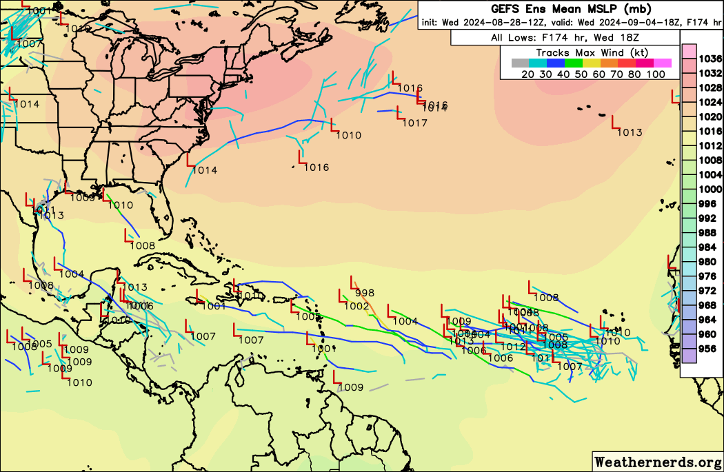
AutoPenalti wrote:LarryWx wrote:12Z GEFS: I can see 6 H from this, with 3 of them hitting or threatening the NE Caribbean.
Not sure where you're looking but the latest noodles from weathernerds site has only TD's.
https://i.postimg.cc/52Pj1khq/gefs-2024-08-28-12-Z-174-50-258-0-350-MSLP-Surface-tracks-lows.png
The H are further out than the 174 hour map you’re showing.
Edit: But actually I see at least 2 H by 174 at TT.
0 likes
Personal Forecast Disclaimer:
The posts in this forum are NOT official forecasts and should not be used as such. They are just the opinion of the poster and may or may not be backed by sound meteorological data. They are NOT endorsed by any professional institution or storm2k.org. For official information, please refer to the NHC and NWS products.
The posts in this forum are NOT official forecasts and should not be used as such. They are just the opinion of the poster and may or may not be backed by sound meteorological data. They are NOT endorsed by any professional institution or storm2k.org. For official information, please refer to the NHC and NWS products.
-
SFLcane

- S2K Supporter
- Posts: 10281
- Age: 48
- Joined: Sat Jun 05, 2010 1:44 pm
- Location: Lake Worth Florida
Re: Disturbed weather in Central Atlantic (0/20)
Hmm.. 20% is on the generous side not much on the gfs or the ecmwf this afternoon. Cmc well thats the cmc lol.
0 likes
-
Stratton23
- Category 5
- Posts: 3477
- Joined: Fri Jul 21, 2023 10:59 pm
- Location: Katy, Tx
-
Spacecoast

- Category 2

- Posts: 773
- Joined: Thu Aug 31, 2017 2:03 pm
Re: Disturbed weather in Central Atlantic (0/20)
LarryWx wrote:AutoPenalti wrote:LarryWx wrote:12Z GEFS: I can see 6 H from this, with 3 of them hitting or threatening the NE Caribbean.
Not sure where you're looking but the latest noodles from weathernerds site has only TD's.
https://i.postimg.cc/52Pj1khq/gefs-2024-08-28-12-Z-174-50-258-0-350-MSLP-Surface-tracks-lows.png
The H are further out than the 174 hour map you’re showing.
Edit: But actually I see at least 2 H by 174 at TT.
It's long been a mystery to me why there is such discrepancy between TT and weathernerds wrt to Ensemble member MSLP mb readings.
TT consistently has lower numbers than weathernerds.
Any explanation would be appreciated...
1 likes
Re: Disturbed weather in Central Atlantic (0/20)
SFLcane wrote:Hmm.. 20% is on the generous side not much on the gfs or the ecmwf this afternoon. Cmc well thats the cmc lol.
I don’t think 20% is really on the generous side as it is still only in the slight chance category. Besides the CMC, I see 6H out of 31 12Z GEFS members. The 12Z ICON is very weak but it does still have a sfc low. Uk has no TC.
Yeah the Euro has little but it still has a very weak low in the W Carib from this at 240. I could tell by following H7 vorticity maps on TT. Of course if it were to wait that long to develop, it would be after the 7 day TWO period.
2 likes
Personal Forecast Disclaimer:
The posts in this forum are NOT official forecasts and should not be used as such. They are just the opinion of the poster and may or may not be backed by sound meteorological data. They are NOT endorsed by any professional institution or storm2k.org. For official information, please refer to the NHC and NWS products.
The posts in this forum are NOT official forecasts and should not be used as such. They are just the opinion of the poster and may or may not be backed by sound meteorological data. They are NOT endorsed by any professional institution or storm2k.org. For official information, please refer to the NHC and NWS products.
-
TomballEd
- Category 5
- Posts: 1243
- Age: 62
- Joined: Wed Aug 16, 2023 4:52 pm
- Location: Spring/Klein area, not Tomball
Re: Disturbed weather in Central Atlantic (0/20)
Decent signal of 6Z Euro ensembles for the AOI,
0 likes
-
Stratton23
- Category 5
- Posts: 3477
- Joined: Fri Jul 21, 2023 10:59 pm
- Location: Katy, Tx
Re: Disturbed weather in Central Atlantic (0/20)
dont like how the EPS shows more members developing in the western caribbean, that could put the gulf in play
0 likes
-
SFLcane
- S2K Supporter
- Posts: 10281
- Age: 48
- Joined: Sat Jun 05, 2010 1:44 pm
- Location: Lake Worth Florida
Re: Disturbed weather in Central Atlantic (0/20)
TomballEd wrote:Decent signal of 6Z Euro ensembles for the AOI,
12z EPS is in the gulf of mexico and in the bahamas.
0 likes
Re: Disturbed weather in Central Atlantic (0/20)
SFLcane wrote:TomballEd wrote:Decent signal of 6Z Euro ensembles for the AOI,
12z EPS is in the gulf of mexico and in the bahamas.
Fwiw the 12Z Euro Control goes from the W Caribbean into the NC Gulf as a strengthening recurving TS.
2 likes
Personal Forecast Disclaimer:
The posts in this forum are NOT official forecasts and should not be used as such. They are just the opinion of the poster and may or may not be backed by sound meteorological data. They are NOT endorsed by any professional institution or storm2k.org. For official information, please refer to the NHC and NWS products.
The posts in this forum are NOT official forecasts and should not be used as such. They are just the opinion of the poster and may or may not be backed by sound meteorological data. They are NOT endorsed by any professional institution or storm2k.org. For official information, please refer to the NHC and NWS products.
Re: Disturbed weather in Central Atlantic (0/20)
SFLcane wrote:TomballEd wrote:Decent signal of 6Z Euro ensembles for the AOI,
12z EPS is in the gulf of mexico and in the bahamas.
The EPS suggests to me fwiw an increased threat to the U.S. Gulf coast from the lemon vs earlier runs.
0 likes
Personal Forecast Disclaimer:
The posts in this forum are NOT official forecasts and should not be used as such. They are just the opinion of the poster and may or may not be backed by sound meteorological data. They are NOT endorsed by any professional institution or storm2k.org. For official information, please refer to the NHC and NWS products.
The posts in this forum are NOT official forecasts and should not be used as such. They are just the opinion of the poster and may or may not be backed by sound meteorological data. They are NOT endorsed by any professional institution or storm2k.org. For official information, please refer to the NHC and NWS products.
-
SFLcane
- S2K Supporter
- Posts: 10281
- Age: 48
- Joined: Sat Jun 05, 2010 1:44 pm
- Location: Lake Worth Florida
Re: Disturbed weather in Central Atlantic (0/20)
LarryWx wrote:SFLcane wrote:TomballEd wrote:Decent signal of 6Z Euro ensembles for the AOI,
12z EPS is in the gulf of mexico and in the bahamas.
The EPS suggests to me fwiw an increased threat to the U.S. Gulf coast from the lemon vs earlier runs.
Can you post the mslp maps not home lol.
0 likes
-
SFLcane
- S2K Supporter
- Posts: 10281
- Age: 48
- Joined: Sat Jun 05, 2010 1:44 pm
- Location: Lake Worth Florida
Re: Disturbed weather in Central Atlantic (0/20)
Wave looks like poop at the moment we shall see what happens overnight.
0 likes
Re: Disturbed weather in Central Atlantic (0/20)
SFLcane wrote:LarryWx wrote:SFLcane wrote:
12z EPS is in the gulf of mexico and in the bahamas.
The EPS suggests to me fwiw an increased threat to the U.S. Gulf coast from the lemon vs earlier runs.
Can you post the mslp maps not home lol.
I can’t as it is from a paid site. I thought you were looking at them, yourself, per your post.
0 likes
Personal Forecast Disclaimer:
The posts in this forum are NOT official forecasts and should not be used as such. They are just the opinion of the poster and may or may not be backed by sound meteorological data. They are NOT endorsed by any professional institution or storm2k.org. For official information, please refer to the NHC and NWS products.
The posts in this forum are NOT official forecasts and should not be used as such. They are just the opinion of the poster and may or may not be backed by sound meteorological data. They are NOT endorsed by any professional institution or storm2k.org. For official information, please refer to the NHC and NWS products.
Who is online
Users browsing this forum: No registered users and 67 guests