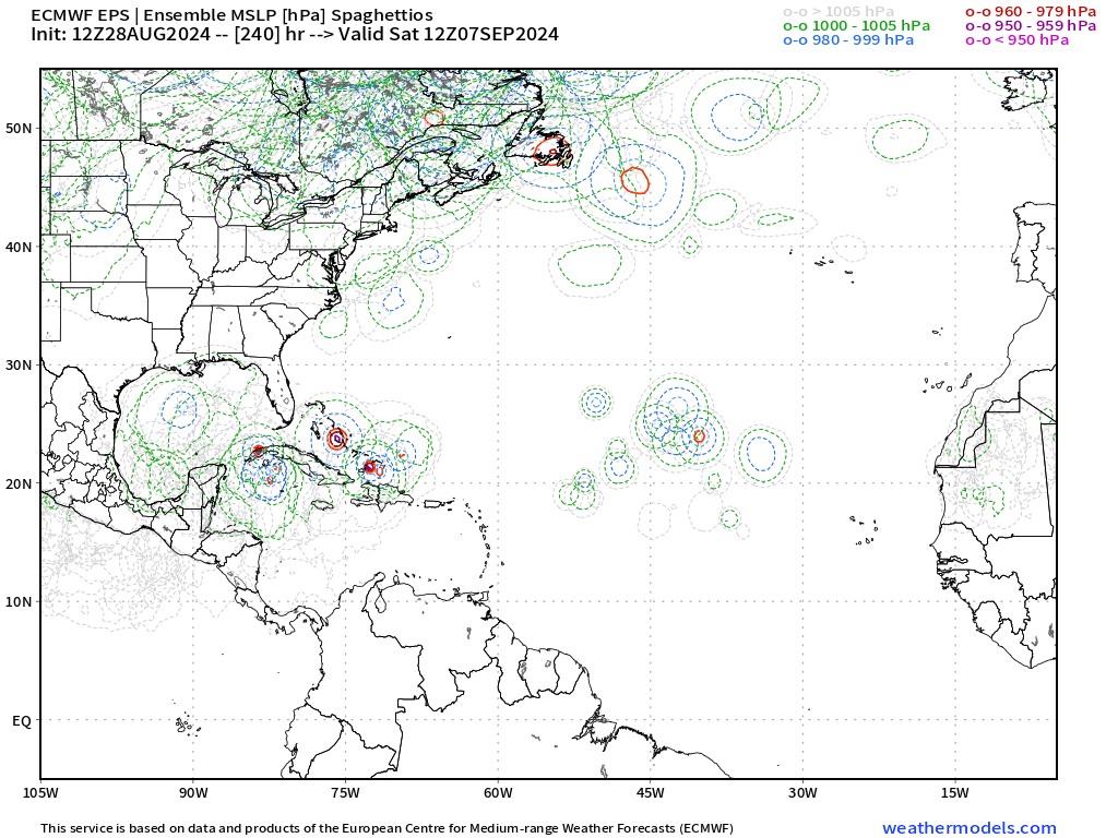
Tropical Wave in Bay of Campeche (Is Invest 91L)

This is the general tropical discussion area. Anyone can take their shot at predicting a storms path.

Moderator: S2k Moderators

Forum rules

The posts in this forum are NOT official forecasts and should not be used as such. They are just the opinion of the poster and may or may not be backed by sound meteorological data. They are NOT endorsed by any professional institution or STORM2K. For official information, please refer to products from the National Hurricane Center and National Weather Service.

Help Support Storm2K
Message
Author
User avatar
SFLcane
S2K Supporter
S2K Supporter
Posts: 10162
Age: 47
Joined: Sat Jun 05, 2010 1:44 pm
Location: Lake Worth Florida

Re: Disturbed weather in Central Atlantic (0/20)

#101 Postby SFLcane » Wed Aug 28, 2024 1:50 pm

LarryWx wrote:
SFLcane wrote:
LarryWx wrote:
The EPS suggests to me fwiw an increased threat to the U.S. Gulf coast from the lemon vs earlier runs.


Can you post the mslp maps not home lol.


I can’t as it is from a paid site. I thought you were looking at them, yourself, per your post.


I am lol.. seems like we are playing this up and down game with both the ops and ensembles models seems like for a few weeks now maybe there is nothing overnight again.
0 likes   

User avatar
SFLcane
S2K Supporter
S2K Supporter
Posts: 10162
Age: 47
Joined: Sat Jun 05, 2010 1:44 pm
Location: Lake Worth Florida

Re: Disturbed weather in Central Atlantic (0/20)

#102 Postby SFLcane » Wed Aug 28, 2024 1:51 pm

:eek:

Image
0 likes   

User avatar
Ivanhater
Storm2k Moderator
Storm2k Moderator
Posts: 11153
Age: 38
Joined: Fri Jul 01, 2005 8:25 am
Location: Pensacola

Re: Disturbed weather in Central Atlantic (0/20)

#103 Postby Ivanhater » Wed Aug 28, 2024 1:57 pm

This is what I mentioned yesterday. If this struggles to develop until Western Caribbean/Bahamas, then it is game on for US and Gulf :eek:
0 likes   
Michael

User avatar
aspen
Category 5
Category 5
Posts: 8812
Joined: Sat Oct 12, 2019 7:10 pm
Location: Connecticut, USA

Re: Disturbed weather in Central Atlantic (0/20)

#104 Postby aspen » Wed Aug 28, 2024 2:13 pm

Operational Euro has the wave slide basically due west into the WCar. Perhaps it may have a chance past 60-70W?
0 likes   
Irene '11 Sandy '12 Hermine '16 5/15/2018 Derecho Fay '20 Isaias '20 Elsa '21 Henri '21 Ida '21

I am only a meteorology enthusiast who knows a decent amount about tropical cyclones. Look to the professional mets, the NHC, or your local weather office for the best information.

Weathertracker96
Tropical Storm
Tropical Storm
Posts: 104
Joined: Mon Oct 16, 2023 3:41 pm

Re: Disturbed weather in Central Atlantic (0/20)

#105 Postby Weathertracker96 » Wed Aug 28, 2024 2:14 pm

Ivanhater wrote:This is what I mentioned yesterday. If this struggles to develop until Western Caribbean/Bahamas, then it is game on for US and Gulf :eek:


I agree with you. With this system possibly waiting to develop and getting in the Caribbean would be trouble. The same steering that could bring it OTS would curve this one up into the Gulf or FL.

I know it’s early but has the Caribbean been more favorable than the MDR lately?
0 likes   

User avatar
SFLcane
S2K Supporter
S2K Supporter
Posts: 10162
Age: 47
Joined: Sat Jun 05, 2010 1:44 pm
Location: Lake Worth Florida

Re: Disturbed weather in Central Atlantic (0/20)

#106 Postby SFLcane » Wed Aug 28, 2024 3:04 pm

Image
5 likes   

MEANINGLESS_NUMBERS
Category 1
Category 1
Posts: 325
Joined: Mon Nov 02, 2020 1:43 pm

Re: Disturbed weather in Central Atlantic (0/20)

#107 Postby MEANINGLESS_NUMBERS » Wed Aug 28, 2024 4:20 pm

Well this is great news for Bermuda.
0 likes   
Emily '87, Felix '95, Gert '99, Fabian '03, Humberto '19, Paulette '20, Teddy '20, Fiona '22, Lee '23, Ernesto '24

Stratton23
Category 5
Category 5
Posts: 2370
Joined: Fri Jul 21, 2023 10:59 pm
Location: Katy, Tx

Re: Disturbed weather in Central Atlantic (0/20)

#108 Postby Stratton23 » Wed Aug 28, 2024 6:11 pm

Of course when the 18z OP GFS goes back to dropping it, now the 18z GEFS has a noticeable uptick in support lol
0 likes   

User avatar
cheezyWXguy
Category 5
Category 5
Posts: 6091
Joined: Mon Feb 13, 2006 12:29 am
Location: Dallas, TX

Re: Disturbed weather in Central Atlantic (0/20)

#109 Postby cheezyWXguy » Wed Aug 28, 2024 6:11 pm

Woah, 18z gefs bringing the fire back
0 likes   

User avatar
Teban54
Category 5
Category 5
Posts: 3168
Joined: Sat May 19, 2018 1:19 pm

Re: Disturbed weather in Central Atlantic (0/20)

#110 Postby Teban54 » Wed Aug 28, 2024 6:17 pm

This loop says it all:

Image

Edit: However, the caveat is that the disturbance was more convectively active when the 18z run was initialized than it is now. It looks like vorticity at all levels have also become a little bit more disorganized. There's a chance that 18z initializations were picking up on the increase in organization and extrapolating it to later hours, and that 0z may similarly become less active. Of course, this can also be just the windshield wiper effect.
Last edited by Teban54 on Wed Aug 28, 2024 6:28 pm, edited 2 times in total.
0 likes   

User avatar
SFLcane
S2K Supporter
S2K Supporter
Posts: 10162
Age: 47
Joined: Sat Jun 05, 2010 1:44 pm
Location: Lake Worth Florida

Re: Disturbed weather in Central Atlantic (0/20)

#111 Postby SFLcane » Wed Aug 28, 2024 6:20 pm

cheezyWXguy wrote:Woah, 18z gefs bringing the fire back


!!
0 likes   

MarioProtVI
Category 4
Category 4
Posts: 932
Age: 23
Joined: Sun Sep 29, 2019 7:33 pm
Location: New Jersey

Re: Disturbed weather in Central Atlantic (0/20)

#112 Postby MarioProtVI » Wed Aug 28, 2024 6:20 pm


Starting to think this windshield wiper effect will continue until the models can latch onto an actual coherent entity because it seems right now the up and down in support seems to be highly dependent on it separating enough from the monsoon trough to not be swept into the vorticity of the eastern AEW on models.
0 likes   

User avatar
Teban54
Category 5
Category 5
Posts: 3168
Joined: Sat May 19, 2018 1:19 pm

Re: Disturbed weather in Central Atlantic (0/20)

#113 Postby Teban54 » Wed Aug 28, 2024 6:23 pm

MarioProtVI wrote:

Starting to think this windshield wiper effect will continue until the models can latch onto an actual coherent entity because it seems right now the up and down in support seems to be highly dependent on it separating enough from the monsoon trough to not be swept into the vorticity of the eastern AEW on models.

Lol, that's almost what I said in the edit :lol:
0 likes   

User avatar
cycloneye
Admin
Admin
Posts: 143865
Age: 68
Joined: Thu Oct 10, 2002 10:54 am
Location: San Juan, Puerto Rico

Re: Tropical Wave in Central Atlantic (0/20)

#114 Postby cycloneye » Wed Aug 28, 2024 6:26 pm

Edited the title to add "Tropical Wave".

Tropical Weather Outlook
NWS National Hurricane Center Miami FL
800 PM EDT Wed Aug 28 2024

For the North Atlantic...Caribbean Sea and the Gulf of Mexico:

1. Central Tropical Atlantic:
A broad area of disorganized showers over the central Tropical
Atlantic are associated with a tropical wave. Some slow development
of this system is possible this weekend into the middle of next week
while it moves westward to west-northwestward at 10 to 15 mph.
* Formation chance through 48 hours...low...near 0 percent.
* Formation chance through 7 days...low...20 percent.


Forecaster Papin
1 likes   
Visit the Caribbean-Central America Weather Thread where you can find at first post web cams,radars
and observations from Caribbean basin members Click Here

LarryWx
Category 5
Category 5
Posts: 6246
Joined: Sun Sep 07, 2003 2:04 pm
Location: GA

Re: Tropical Wave in Central Atlantic (0/20)

#115 Postby LarryWx » Wed Aug 28, 2024 7:55 pm

cycloneye wrote:Edited the title to add "Tropical Wave".

Tropical Weather Outlook
NWS National Hurricane Center Miami FL
800 PM EDT Wed Aug 28 2024

For the North Atlantic...Caribbean Sea and the Gulf of Mexico:

1. Central Tropical Atlantic:
A broad area of disorganized showers over the central Tropical
Atlantic are associated with a tropical wave. Some slow development
of this system is possible this weekend into the middle of next week
while it moves westward to west-northwestward at 10 to 15 mph.
* Formation chance through 48 hours...low...near 0 percent.
* Formation chance through 7 days...low...20 percent.


Forecaster Papin


It’s moving a little slower than the avg wave, which is closer to 15. This one is only 10-15.
0 likes   
Personal Forecast Disclaimer:
The posts in this forum are NOT official forecasts and should not be used as such. They are just the opinion of the poster and may or may not be backed by sound meteorological data. They are NOT endorsed by any professional institution or storm2k.org. For official information, please refer to the NHC and NWS products.

User avatar
Ubuntwo
Category 5
Category 5
Posts: 1401
Age: 31
Joined: Thu Oct 05, 2017 10:41 pm

Re: Tropical Wave in Central Atlantic (0/20)

#116 Postby Ubuntwo » Wed Aug 28, 2024 8:04 pm

18z EPS looks like an uptick with ~40% of members with a TS by day 7. The GEFS similarly ticked up to ~35% at 18z, climbing later in the run. Windshield wipering or the start of a trend?
1 likes   
Kendall -> SLO -> PBC

Memorable Storms: Katrina (for its Florida landfall...) Wilma Matthew Irma

LarryWx
Category 5
Category 5
Posts: 6246
Joined: Sun Sep 07, 2003 2:04 pm
Location: GA

Re: Tropical Wave in Central Atlantic (0/20)

#117 Postby LarryWx » Wed Aug 28, 2024 8:15 pm

Ubuntwo wrote:18z EPS looks like an uptick with ~40% of members with a TS by day 7. The GEFS similarly ticked up to ~35% at 18z, climbing later in the run. Windshield wipering or the start of a trend?


Per my eyeballs, I count at least 13 of the 31 GEFS members on TT with a TC. And based on more eyeballing, this looks like the most active from the current lemon since the 18Z two days ago. I wouldn’t read too much into this though as it could just be a one off run. Let’s see what 0Z shows.

I know Teban has been counting more closely the members. Is this the most active for just the lemon since the 6Z of 8/26?
1 likes   
Personal Forecast Disclaimer:
The posts in this forum are NOT official forecasts and should not be used as such. They are just the opinion of the poster and may or may not be backed by sound meteorological data. They are NOT endorsed by any professional institution or storm2k.org. For official information, please refer to the NHC and NWS products.

User avatar
Spacecoast
Category 2
Category 2
Posts: 758
Joined: Thu Aug 31, 2017 2:03 pm

Re: Tropical Wave in Central Atlantic (0/20)

#118 Postby Spacecoast » Wed Aug 28, 2024 8:29 pm

From the 12z EPS @336Hour....
Image

Is that 918 mb??
Very strong.
0 likes   

User avatar
Teban54
Category 5
Category 5
Posts: 3168
Joined: Sat May 19, 2018 1:19 pm

Re: Tropical Wave in Central Atlantic (0/20)

#119 Postby Teban54 » Wed Aug 28, 2024 8:31 pm

LarryWx wrote:
Ubuntwo wrote:18z EPS looks like an uptick with ~40% of members with a TS by day 7. The GEFS similarly ticked up to ~35% at 18z, climbing later in the run. Windshield wipering or the start of a trend?


Per my eyeballs, I count at least 13 of the 31 GEFS members on TT with a TC. And based on more eyeballing, this looks like the most active from the current lemon since the 18Z two days ago. I wouldn’t read too much into this though as it could just be a one off run. Let’s see what 0Z shows.

I know Teban has been counting more closely the members. Is this the most active for just the lemon since the 6Z of 8/26?

Glad there's still interest! To be honest, I kind of skipped 12z because it was hard to tell the members that developed this wave past Lesser Antilles, but let me try again.

GEFS member low pressure counts (±2, out of 31):
  • 18z 8/28: 13 (42%) as of Eastern Caribbean
  • 12z 8/28: 7 (23%) as of Eastern Caribbean (a few members start in WCar, but unsure if they're from this wave or a CAG)
  • 6z 8/28: 9 (29%)
  • 0z 8/28: 9 (29%)
  • 18z 8/27: 4 (13%)
  • 12z 8/27: 9 (29%)
  • 6z 8/27: 14 (45%)
  • 0z 8/27: 9 (29%)
  • 18z 8/26: 19 (61%)
  • 12z 8/26: 17 (55%)
  • 6z 8/26: 19 (61%)
  • 0z 8/26: 16 (52%)
  • 18z 8/25: 10 (32%)
  • 12z 8/25: 14 (45%)
EPS member low pressure counts (±3, out of 51):
  • 18z 8/28 (out to 144 hrs only): 33 (65%, some may not be TCs)
  • 12z 8/28: 18 (35%) as of Eastern Caribbean (a few members dissipate there, a few develop in WCar)
  • 6z 8/28 (out to 144 hrs only): 21 (41%, some may not be TCs)
  • 0z 8/28: 11 (22%)
  • 18z 8/27 (out to 144 hrs only): 15 (29%)
  • 12z 8/27: 14 (27%)
  • 6z 8/27 (out to 144 hrs only): 20 (39%)
  • 0z 8/27: 25 (49%)
  • 18z 8/26 (out to 144 hrs only): 27 (53%)
  • 12z 8/26: 34 (67%)
  • 0z 8/26: 22 (43%)
  • 12z 8/25: 11 (22%)

Today's 18z EPS is close to the most active run ever (that's 12z 8/26), though that's helped by a few members that seem to only have the low form in Eastern Caribbean. Note that not all of these systems are TCs, never mind TSes. On the other hand, some members may also only develop the wave once it gets to Western Caribbean or the Gulf.

18z GEFS is the most active over the past 6 runs, but still less so than the most active day ever (8/26). However, it's a quality-over-quantity situation, as the members that do form are pretty strong as they hit or brush the Caribbean islands.
2 likes   

TomballEd
Category 2
Category 2
Posts: 580
Age: 61
Joined: Wed Aug 16, 2023 4:52 pm
Location: Spring/Klein area, not Tomball

Re: Tropical Wave in Central Atlantic (0/20)

#120 Postby TomballEd » Wed Aug 28, 2024 8:34 pm

Ubuntwo wrote:18z EPS looks like an uptick with ~40% of members with a TS by day 7. The GEFS similarly ticked up to ~35% at 18z, climbing later in the run. Windshield wipering or the start of a trend?


Image
0 likes   


Return to “Talkin' Tropics”

Who is online

Users browsing this forum: No registered users and 63 guests