2024 Global Model Runs Discussion (Out thru day 16)
Moderator: S2k Moderators
Forum rules

The posts in this forum are NOT official forecasts and should not be used as such. They are just the opinion of the poster and may or may not be backed by sound meteorological data. They are NOT endorsed by any professional institution or STORM2K. For official information, please refer to products from the National Hurricane Center and National Weather Service.

Re: 2024 Global Model Runs Discussion (Out thru day 16)
12z GFS, 12z Euro and 18z GFS all at least make an attempt to spin up the eastern MDR system, with 18z GFS being the most organized, but still weak and short-lived. There's still healthy ensemble support, with a few members from each model do show a formidable system (though they're probably just outliers for now).
0 likes
TC naming lists: retirements and intensity
Most aggressive Advisory #1's in North Atlantic (cr. kevin for starting the list)
Most aggressive Advisory #1's in North Atlantic (cr. kevin for starting the list)

Re: RE: Re: 2024 Global Model Runs Discussion (Out thru day 16)
Jr0d wrote:jlauderdal wrote:Accepted, s2k wins either way and im good with that.Jr0d wrote:I am willing to bet that by Labor Day weekend(August 31st) that somewhere in the CONUS will be either in an orange potential development cone or in the cone of uncertainty from a classified system.
If I am wrong I will give Storm2k $10...if anyone takes me up on the bet and I am right, they will donate $10...
Any takers?
60 hours to go. Looking likely I will be making the donation..though I do think the area in the Gulf may surprise us in the next 48 hours.
That is what I thought a week ago when the GFS ran with the trough split. Surface pressure is down around 1010 MB off Brownsville which looks like its under high pressure aloft. WXman57 said next trough to get down in the gulf may be delayed. NHC lemon threshold must be down near 1008 mb?
1 likes
Re: 2024 Global Model Runs Discussion (Out thru day 16)
Teban54 wrote:12z GFS, 12z Euro and 18z GFS all at least make an attempt to spin up the eastern MDR system, with 18z GFS being the most organized, but still weak and short-lived. There's still healthy ensemble support, with a few members from each model do show a formidable system (though they're probably just outliers for now).
I'll start counting ensemble support for the Eastern Atlantic wave (exiting Africa within a handful days), just because.
This list counts all Eastern Atlantic lows on roughly 9/7. Some GEFS runs have over 100% of members developing, which suggests some members may see two lows at the same time (possibly from two different waves). At this lead time, it's impossible to distinguish the waves due to high variance, so I'm just counting all of them.
GEFS member low pressure counts (±2, out of 31):
- 18z 8/28: 35 (113%)
- 12z 8/28: 22 (71%)
- 6z 8/28: 23 (74%)
- 0z 8/28: 22 (71%)
- 18z 8/28 (out to 144 hrs only): 26 (51%)
- 12z 8/28: 37 (73%)
- 6z 8/28 (out to 144 hrs only): 22 (43%)
- 0z 8/28: 31 (61%)
Based on the ensemble support and some operational model support (even if on-and-off or not very well organized), I wouldn't be surprised to see a lemon in the next day or two.
2 likes
TC naming lists: retirements and intensity
Most aggressive Advisory #1's in North Atlantic (cr. kevin for starting the list)
Most aggressive Advisory #1's in North Atlantic (cr. kevin for starting the list)
Re: 2024 Global Model Runs Discussion (Out thru day 16)
This is not a serious post, but just for funsies:
Here's an insane EPS member from 12z. This is from the eastern Atlantic wave (not the 0/20 lemon), which starts off as a weak TS just like most other members. But then it gets into the dreaded WSW dive and intensifies along the way, hitting Montserrat in the process. It bombs out in the eastern Caribbean, finishing the run at 922 mb.
This will almost certainly not happen... But
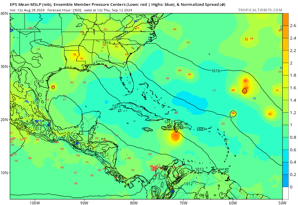
1 likes
TC naming lists: retirements and intensity
Most aggressive Advisory #1's in North Atlantic (cr. kevin for starting the list)
Most aggressive Advisory #1's in North Atlantic (cr. kevin for starting the list)
-
redingtonbeach
- Tropical Depression

- Posts: 65
- Joined: Mon Sep 04, 2017 12:05 am
Re: 2024 Global Model Runs Discussion (Out thru day 16)
N2FSU wrote:12z Canadian:
https://uploads.tapatalk-cdn.com/20240828/5496e6b1914f05377e5ecef2c963d29c.jpg
https://uploads.tapatalk-cdn.com/20240828/2536734ef0ef52e020735abd036c7751.jpg
Sent from my iPhone using Tapatalk
Saw this. Ensembles are picking up a smaller wave too.
0 likes

Re: 2024 Global Model Runs Discussion (Out thru day 16)


GFS similarly shows development, but not quite as soon. Seems like we're getting a Bret scenario again, where the models dont really zero in on something for certain until a few days out
2 likes
The above post is not official and should not be used as such. It is the opinion of the poster and may or may not be backed by sound meteorological data. It is not endorsed by any professional institution or storm2k.org. For official information, please refer to the NHC and NWS products.
Re: 2024 Global Model Runs Discussion (Out thru day 16)
0z GFS: (Full run below)
0z CMC:
0z ICON:
- 0/20 AOI: Develops in eastern Caribbean, Cat 1 hit on Haiti, takes the worst possible path (hugging Cuba's northern coastline) and gets shredded as the result. Of course, too early to speculate on track, but this is the first time it developed this system since 18z 8/26.
- Eastern Atlantic system: Develops and recurves near 40W similar to earlier runs, somehow plows through the TUTT (or perhaps ventilated by it?), gets to 963 mb in the subtropics.
- A third wave organizes in the eastern MDR beyond Day 11, becoming a TS by the end of the run.
0z CMC:
- 0/20 AOI: Develops in the western MDR, clips Haiti and Cuba, run ends with Cat 1 landfall on SE Florida.
- Eastern Atlantic system: Developing at the end of the run (240 hrs), but much further east than earlier runs on all global models, near CV islands.
0z ICON:
- 0/20 AOI: Develops in the western MDR, run ends as a hurricane south of DR (180 hrs), further south than GFS and CMC
- Eastern Atlantic system: Starts organizing in 3 days or so, continues to be the most aggressive of all global models.
0 likes
TC naming lists: retirements and intensity
Most aggressive Advisory #1's in North Atlantic (cr. kevin for starting the list)
Most aggressive Advisory #1's in North Atlantic (cr. kevin for starting the list)
-
skyline385

- Category 5

- Posts: 2728
- Age: 35
- Joined: Wed Aug 26, 2020 11:15 pm
- Location: Houston TX
Re: 2024 Global Model Runs Discussion (Out thru day 16)
In addition to ICON, CMC and GFS all upticking for the 0z runs for our AOI, Euro came in pretty damn strong as well.

1 likes

Re: 2024 Global Model Runs Discussion (Out thru day 16)
skyline385 wrote:In addition to ICON, CMC and GFS all upticking for the 0z runs for our AOI, Euro came in pretty damn strong as well.
https://i.imgur.com/c4Uq7xs.png
We have a separate thread for this AOI
1 likes
Kendall -> SLO -> PBC
Memorable Storms: Katrina (for its Florida landfall...) Wilma Matthew Irma
Memorable Storms: Katrina (for its Florida landfall...) Wilma Matthew Irma
-
skyline385
- Category 5
- Posts: 2728
- Age: 35
- Joined: Wed Aug 26, 2020 11:15 pm
- Location: Houston TX
Re: 2024 Global Model Runs Discussion (Out thru day 16)
Ubuntwo wrote:skyline385 wrote:In addition to ICON, CMC and GFS all upticking for the 0z runs for our AOI, Euro came in pretty damn strong as well.
https://i.imgur.com/c4Uq7xs.png
We have a separate thread for this AOI
oh right, had completely forgotten about that thread. Thanks!
1 likes
Re: 2024 Global Model Runs Discussion (Out thru day 16)
Is Tropical Tidbits down?
0 likes
The above post is not official and should not be used as such. It is the opinion of the poster and may or may not be backed by sound meteorological data. It is not endorsed by any professional institution or storm2k.org. For official information, please refer to the NHC and NWS products.
-
cycloneye

- Admin

- Posts: 149727
- Age: 69
- Joined: Thu Oct 10, 2002 10:54 am
- Location: San Juan, Puerto Rico
Re: 2024 Global Model Runs Discussion (Out thru day 16)
Hammy wrote:Is Tropical Tidbits down?
Yes, aparently it crashed after the 00z model runs.
1 likes
Visit the Caribbean-Central America Weather Thread where you can find at first post web cams,radars
and observations from Caribbean basin members Click Here
and observations from Caribbean basin members Click Here
-
TomballEd
- Category 5
- Posts: 1322
- Age: 62
- Joined: Wed Aug 16, 2023 4:52 pm
- Location: Spring/Klein area, not Tomball
Re: 2024 Global Model Runs Discussion (Out thru day 16)
cycloneye wrote:Hammy wrote:Is Tropical Tidbits down?
Yes, aparently it crashed after the 00z model runs.
Can anyone post the Euro ensembles past 240 hours? I would be looking at TT for >240 hour EPS.
0 likes
-
USTropics
- Professional-Met

- Posts: 2741
- Joined: Sun Aug 12, 2007 3:45 am
- Location: Florida State University
Re: 2024 Global Model Runs Discussion (Out thru day 16)
TomballEd wrote:cycloneye wrote:Hammy wrote:Is Tropical Tidbits down?
Yes, aparently it crashed after the 00z model runs.
Can anyone post the Euro ensembles past 240 hours? I would be looking at TT for >240 hour EPS.
There are limited region extents on Pivotal, but here is the 00z ECMWF individual ensemble member MSLPs for the Caribbean/GOM for 72-360 hours:

https://www.pivotalweather.com/model.php?m=epsens&p=sfcmslp-meanmem&rh=2024082900&fh=0&r=caribbean&dpdt=&mc=
1 likes
-
skyline385
- Category 5
- Posts: 2728
- Age: 35
- Joined: Wed Aug 26, 2020 11:15 pm
- Location: Houston TX
Re: 2024 Global Model Runs Discussion (Out thru day 16)
TomballEd wrote:cycloneye wrote:Hammy wrote:Is Tropical Tidbits down?
Yes, aparently it crashed after the 00z model runs.
Can anyone post the Euro ensembles past 240 hours? I would be looking at TT for >240 hour EPS.
0z EPS and GEFS


1 likes
-
jlauderdal
- S2K Supporter

- Posts: 7240
- Joined: Wed May 19, 2004 5:46 am
- Location: NE Fort Lauderdale
- Contact:
Re: 2024 Global Model Runs Discussion (Out thru day 16)
skyline385 wrote:TomballEd wrote:cycloneye wrote:
Yes, aparently it crashed after the 00z model runs.
Can anyone post the Euro ensembles past 240 hours? I would be looking at TT for >240 hour EPS.
0z EPS and GEFS
https://i.imgur.com/Bzrdmg2.png
https://i.imgur.com/ZENXGmH.png
Cycloneye in an ensemble sandwich.
2 likes
-
cycloneye
- Admin
- Posts: 149727
- Age: 69
- Joined: Thu Oct 10, 2002 10:54 am
- Location: San Juan, Puerto Rico
Re: 2024 Global Model Runs Discussion (Out thru day 16)
Great news= Tropical Tidbits site is back!!!
https://x.com/TropicalTidbits/status/1829166789202510280
https://www.tropicaltidbits.com/sat/
https://x.com/TropicalTidbits/status/1829166789202510280
https://www.tropicaltidbits.com/sat/
4 likes
Visit the Caribbean-Central America Weather Thread where you can find at first post web cams,radars
and observations from Caribbean basin members Click Here
and observations from Caribbean basin members Click Here
Re: 2024 Global Model Runs Discussion (Out thru day 16)
12Z UKMET: has TD form at 162 hrs 100 miles ESE of Corpus Christi nearly stationary
NEW TROPICAL CYCLONE FORECAST TO DEVELOP AFTER 162 HOURS
FORECAST POSITION AT T+162 : 27.0N 95.6W
LEAD CENTRAL MAXIMUM WIND
VERIFYING TIME TIME POSITION PRESSURE (MB) SPEED (KNOTS)
-------------- ---- -------- ------------- -------------
1200UTC 05.09.2024 168 26.8N 95.6W 1007 28
NEW TROPICAL CYCLONE FORECAST TO DEVELOP AFTER 162 HOURS
FORECAST POSITION AT T+162 : 27.0N 95.6W
LEAD CENTRAL MAXIMUM WIND
VERIFYING TIME TIME POSITION PRESSURE (MB) SPEED (KNOTS)
-------------- ---- -------- ------------- -------------
1200UTC 05.09.2024 168 26.8N 95.6W 1007 28
0 likes
Personal Forecast Disclaimer:
The posts in this forum are NOT official forecasts and should not be used as such. They are just the opinion of the poster and may or may not be backed by sound meteorological data. They are NOT endorsed by any professional institution or storm2k.org. For official information, please refer to the NHC and NWS products.
The posts in this forum are NOT official forecasts and should not be used as such. They are just the opinion of the poster and may or may not be backed by sound meteorological data. They are NOT endorsed by any professional institution or storm2k.org. For official information, please refer to the NHC and NWS products.
-
Stratton23
- Category 5
- Posts: 3577
- Joined: Fri Jul 21, 2023 10:59 pm
- Location: Katy, Tx
Re: 2024 Global Model Runs Discussion (Out thru day 16)
LarryWx interesting, I dont have access to that model, but ive heard the UKMET does a pretty good job at sniffing out potential systems
1 likes
-
Stratton23
- Category 5
- Posts: 3577
- Joined: Fri Jul 21, 2023 10:59 pm
- Location: Katy, Tx
Re: 2024 Global Model Runs Discussion (Out thru day 16)
Cycloneye i think its still down, because a lot of the data/ models are still stuck on 00z runs from last night, some are just starting now i think
0 likes
Who is online
Users browsing this forum: bird and 94 guests