
Tropical Wave in Bay of Campeche (Is Invest 91L)
Moderator: S2k Moderators
Forum rules

The posts in this forum are NOT official forecasts and should not be used as such. They are just the opinion of the poster and may or may not be backed by sound meteorological data. They are NOT endorsed by any professional institution or STORM2K. For official information, please refer to products from the National Hurricane Center and National Weather Service.

Re: Tropical Wave in Central Atlantic (0/20)
Teban54 wrote:LarryWx wrote:Ubuntwo wrote:18z EPS looks like an uptick with ~40% of members with a TS by day 7. The GEFS similarly ticked up to ~35% at 18z, climbing later in the run. Windshield wipering or the start of a trend?
Per my eyeballs, I count at least 13 of the 31 GEFS members on TT with a TC. And based on more eyeballing, this looks like the most active from the current lemon since the 18Z two days ago. I wouldn’t read too much into this though as it could just be a one off run. Let’s see what 0Z shows.
I know Teban has been counting more closely the members. Is this the most active for just the lemon since the 6Z of 8/26?
Glad there's still interest! To be honest, I kind of skipped 12z because it was hard to tell the members that developed this wave past Lesser Antilles, but let me try again.
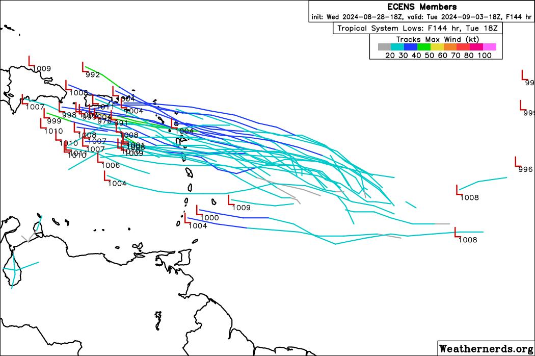
GEFS member low pressure counts (±2, out of 31):EPS member low pressure counts (±3, out of 51):
- 18z 8/28: 13 (42%) as of Eastern Caribbean
- 12z 8/28: 7 (23%) as of Eastern Caribbean (a few members start in WCar, but unsure if they're from this wave or a CAG)
- 6z 8/28: 9 (29%)
- 0z 8/28: 9 (29%)
- 18z 8/27: 4 (13%)
- 12z 8/27: 9 (29%)
- 6z 8/27: 14 (45%)
- 0z 8/27: 9 (29%)
- 18z 8/26: 19 (61%)
- 12z 8/26: 17 (55%)
- 6z 8/26: 19 (61%)
- 0z 8/26: 16 (52%)
- 18z 8/25: 10 (32%)
- 12z 8/25: 14 (45%)
- 18z 8/28 (out to 144 hrs only): 33 (65%, some may not be TCs)
- 12z 8/28: 18 (35%) as of Eastern Caribbean (a few members dissipate there, a few develop in WCar)
- 6z 8/28 (out to 144 hrs only): 21 (41%, some may not be TCs)
- 0z 8/28: 11 (22%)
- 18z 8/27 (out to 144 hrs only): 15 (29%)
- 12z 8/27: 14 (27%)
- 6z 8/27 (out to 144 hrs only): 20 (39%)
- 0z 8/27: 25 (49%)
- 18z 8/26 (out to 144 hrs only): 27 (53%)
- 12z 8/26: 34 (67%)
- 0z 8/26: 22 (43%)
- 12z 8/25: 11 (22%)
Today's 18z EPS is close to the most active run ever (that's 12z 8/26), though that's helped by a few members that seem to only have the low form in Eastern Caribbean. Note that not all of these systems are TCs, never mind TSes. On the other hand, some members may also only develop the wave once it gets to Western Caribbean or the Gulf.
18z GEFS is the most active over the past 6 runs, but still less so than the most active day ever (8/26). However, it's a quality-over-quantity situation, as the members that do form are pretty strong as they hit or brush the Caribbean islands.
I looked member-by-member to get the 40% count for the latest EPS. The additional ~25% look like closed or nearly closed lows on the verge of developing, but not truly classifiable by day 7. In absolute numbers that puts it close to 12z 8/26, though that run had a much higher proportion of intense members by day 7. The story for today is continued moderate support with increased chances of delayed development. And chances that we see nothing are still around a coin flip.
2 likes
Kendall -> SLO -> PBC
Memorable Storms: Katrina (for its Florida landfall...) Wilma Matthew Irma
Memorable Storms: Katrina (for its Florida landfall...) Wilma Matthew Irma
-
Spacecoast

- Category 2

- Posts: 773
- Joined: Thu Aug 31, 2017 2:03 pm

Re: Tropical Wave in Central Atlantic (0/20)
Spacecoast wrote:18z EC-AIFS
https://i.ibb.co/sKb5stL/ec-aifs-mslp-wind-watl-fh96-312.gif
Wow, this is bizarre! To review, 23 straight EC-AIFS runs from 6Z 8/19 through 18Z 8/24 had TCG ~9/2 near the Leewards. Then the next 15 had nothing (not even a weak sfc low) anywhere around there. Now all of the sudden, the 18Z 8/28 EC-AIFS has a weak sfc low (though not a TC) that forms on 9/2 near the central Lesser Antilles (so a little S of those 23 runs).
0 likes
Personal Forecast Disclaimer:
The posts in this forum are NOT official forecasts and should not be used as such. They are just the opinion of the poster and may or may not be backed by sound meteorological data. They are NOT endorsed by any professional institution or storm2k.org. For official information, please refer to the NHC and NWS products.
The posts in this forum are NOT official forecasts and should not be used as such. They are just the opinion of the poster and may or may not be backed by sound meteorological data. They are NOT endorsed by any professional institution or storm2k.org. For official information, please refer to the NHC and NWS products.

Re: Tropical Wave in Central Atlantic (0/20)
LarryWx wrote:Spacecoast wrote:18z EC-AIFS
https://i.ibb.co/sKb5stL/ec-aifs-mslp-wind-watl-fh96-312.gif
Wow, this is bizarre! To review, 23 straight EC-AIFS runs from 6Z 8/19 through 18Z 8/24 had TCG ~9/2 near the Leewards. Then the next 15 had nothing (not even a weak sfc low) anywhere around there. Now all of the sudden, the 18Z 8/28 EC-AIFS has a weak sfc low (though not a TC) that forms on 9/2 near the central Lesser Antilles (so a little S of those 23 runs).
This is the moment when I have to wonder how much ECAI learned on the climo during training. I assume the training data being fed into the model is a large amount of historical weather data, which includes past hurricane tracks. It can pick up signals that "on September 2, there's an elevated chance of a TC near Puerto Rico and an elevated chance of a Caribbean cruiser". How much role that plays relative to current conditions is unknown, perhaps even to the machine learning engineers.
1 likes
TC naming lists: retirements and intensity
Most aggressive Advisory #1's in North Atlantic (cr. kevin for starting the list)
Most aggressive Advisory #1's in North Atlantic (cr. kevin for starting the list)
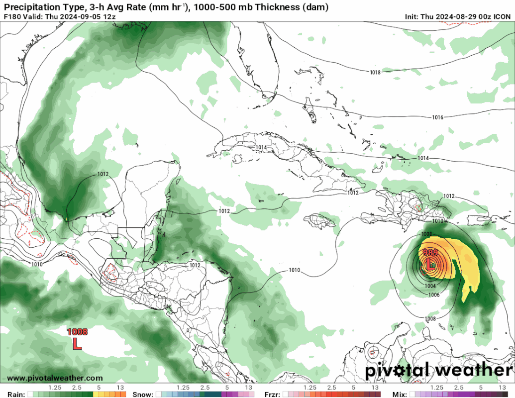
Re: Tropical Wave in Central Atlantic (0/20)
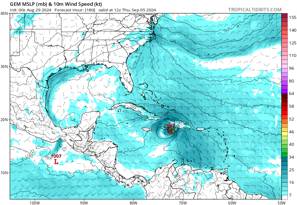
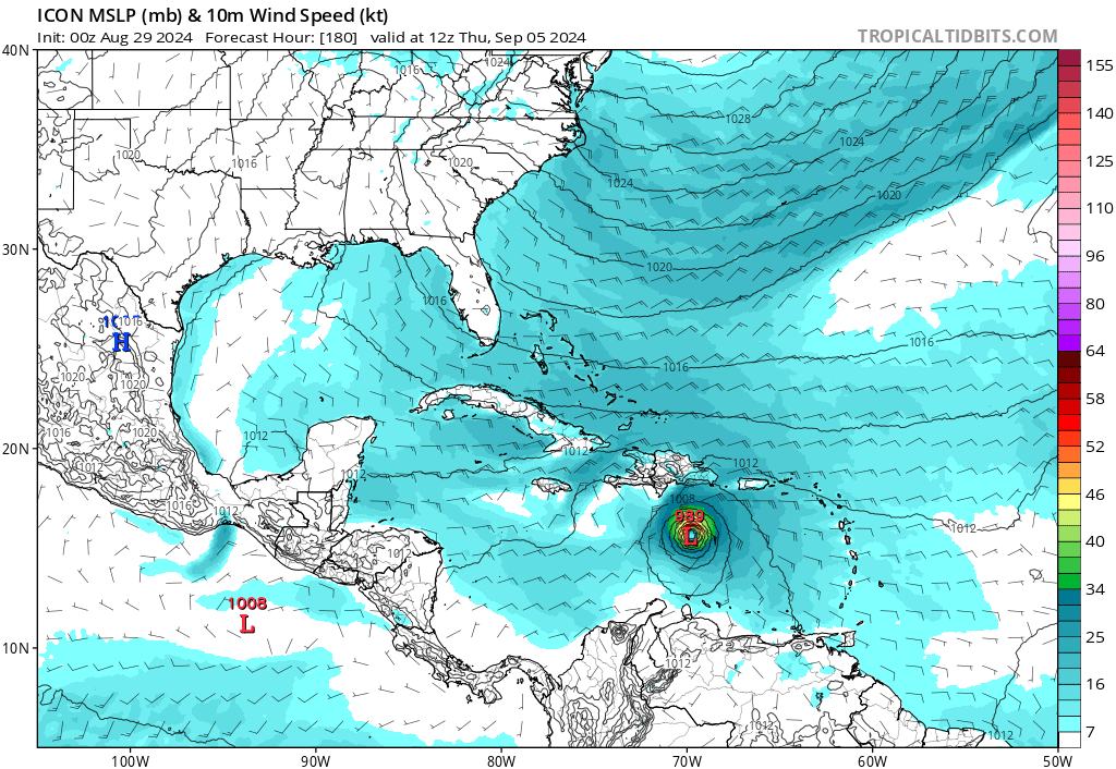
0z ICON is developing a TS again, right around the 5 day mark. Tracks through the eastern Caribbean while steadily intensifying. Edit: Appears to end the run as a hurricane in the Central Caribbean.
3 likes
Kendall -> SLO -> PBC
Memorable Storms: Katrina (for its Florida landfall...) Wilma Matthew Irma
Memorable Storms: Katrina (for its Florida landfall...) Wilma Matthew Irma
-
Stratton23
- Category 5

- Posts: 3577
- Joined: Fri Jul 21, 2023 10:59 pm
- Location: Katy, Tx
Re: Tropical Wave in Central Atlantic (0/20)
ICON finishes its run with a hurricane headed due west, big strong ridge to its north, looks like a gulf storm if the model went out any further
0 likes
-
Category5Kaiju

- Category 5
- Posts: 4347
- Joined: Thu Dec 24, 2020 12:45 pm
- Location: Seattle during the summer, Phoenix during the winter
Re: Tropical Wave in Central Atlantic (0/20)
Looks like we are starting to see some subtle signs that whatever forms out of this AOI isn't going to easily recurve on out to sea, unlike model ideas several days ago.
1 likes
Unless explicitly stated, all information in my posts is based on my own opinions and observations. Tropical storms and hurricanes can be extremely dangerous. Refer to an accredited weather research agency or meteorologist if you need to make serious decisions regarding an approaching storm.
-
MarioProtVI
- Category 5
- Posts: 1039
- Age: 24
- Joined: Sun Sep 29, 2019 7:33 pm
- Location: New Jersey
Re: Tropical Wave in Central Atlantic (0/20)
If current trends continue, this could be another Caribbean Crusier that racks up a good amount of ACE, perhaps close to around 20-25 ACE, IF it continues west. Let’s see though. Maybe the switch flip is kicking in for real now and just got delayed somewhat by weird atmospheric processes.
0 likes
Re: Tropical Wave in Central Atlantic (0/20)
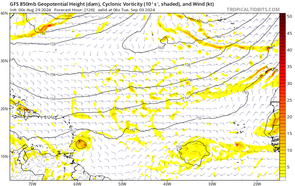
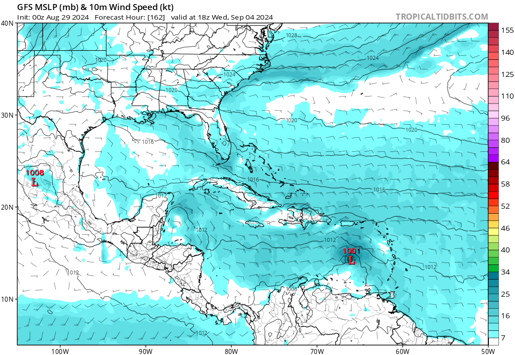
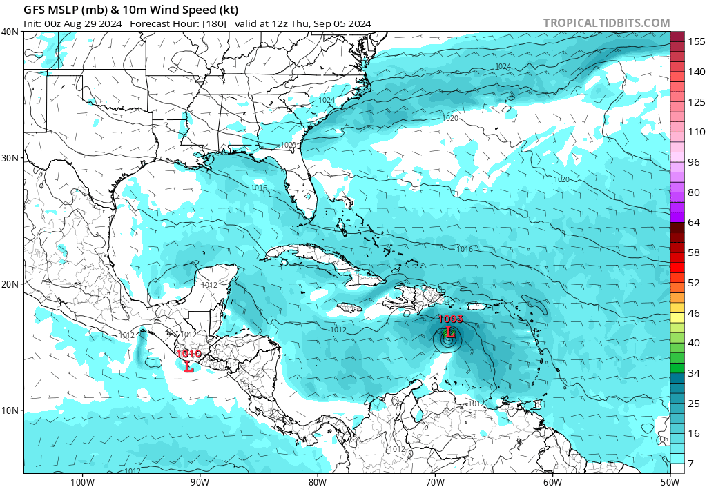
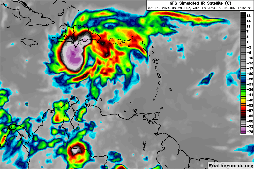
0z GFS out to 126 hrs has the most concentrated vorticity for this system out of all its runs -- by far -- entering the Caribbean as a low rider, well south of its ensembles. Seems to be on its way to development even with no notable low pressure yet (edit: 1011 mb in the next frame).
Edit 2: Clear-cut TC in the Caribbean by 162 hrs.
Edit 2: Clear-cut TC in the Caribbean by 162 hrs.
Last edited by Teban54 on Wed Aug 28, 2024 11:23 pm, edited 1 time in total.
0 likes
TC naming lists: retirements and intensity
Most aggressive Advisory #1's in North Atlantic (cr. kevin for starting the list)
Most aggressive Advisory #1's in North Atlantic (cr. kevin for starting the list)
-
AtlanticWind

- S2K Supporter

- Posts: 1898
- Age: 67
- Joined: Sun Aug 08, 2004 9:57 pm
- Location: Plantation,Fla
Re: Tropical Wave in Central Atlantic (0/20)
Gfs showing a little something now, model support definitely increasing this evening.
0 likes
Re: Tropical Wave in Central Atlantic (0/20)
Teban54 wrote:0z GFS out to 126 hrs has the most concentrated vorticity for this system out of all its runs -- by far -- entering the Caribbean as a low rider, well south of its ensembles. Seems to be on its way to development even with no notable low pressure yet (edit: 1011 mb in the next frame).
https://i.postimg.cc/4y9dh8HY/image.png
Well, it did have the run with the recurving hurricane
Last edited by Ubuntwo on Wed Aug 28, 2024 11:34 pm, edited 1 time in total.
0 likes
Kendall -> SLO -> PBC
Memorable Storms: Katrina (for its Florida landfall...) Wilma Matthew Irma
Memorable Storms: Katrina (for its Florida landfall...) Wilma Matthew Irma
-
lsuhurricane
- Category 1

- Posts: 270
- Joined: Tue Aug 15, 2017 2:53 pm
Re: Tropical Wave in Central Atlantic (0/20)
Canadian has a bonified hurricane headed westward. This one finally has legs…..
0 likes
Re: Tropical Wave in Central Atlantic (0/20)
We're back baby, we're so back 
(On a more serious note, the last time there was finally model agreement on all globals with the 18z 8/26 GFS run, they immediately started dropping development just 6 hours later. But...)
Edit: More descriptions of each model run in the global models thread.
(On a more serious note, the last time there was finally model agreement on all globals with the 18z 8/26 GFS run, they immediately started dropping development just 6 hours later. But...)
Edit: More descriptions of each model run in the global models thread.
Last edited by Teban54 on Thu Aug 29, 2024 12:19 am, edited 1 time in total.
1 likes
TC naming lists: retirements and intensity
Most aggressive Advisory #1's in North Atlantic (cr. kevin for starting the list)
Most aggressive Advisory #1's in North Atlantic (cr. kevin for starting the list)
-
Category5Kaiju
- Category 5
- Posts: 4347
- Joined: Thu Dec 24, 2020 12:45 pm
- Location: Seattle during the summer, Phoenix during the winter
Re: Tropical Wave in Central Atlantic (0/20)
CMC has this taking a Cleo-like track.
1 likes
Unless explicitly stated, all information in my posts is based on my own opinions and observations. Tropical storms and hurricanes can be extremely dangerous. Refer to an accredited weather research agency or meteorologist if you need to make serious decisions regarding an approaching storm.
-
ElectricStorm

- Category 5
- Posts: 5156
- Age: 25
- Joined: Tue Aug 13, 2019 11:23 pm
- Location: Norman, OK
Re: Tropical Wave in Central Atlantic (0/20)
1. Central Tropical Atlantic:
A broad area of disorganized showers over the central Tropical
Atlantic are associated with a tropical wave. Some slow development
of this system is possible this weekend into the middle of next week
while it moves westward to west-northwestward at 10 to 15 mph.
* Formation chance through 48 hours...low...near 0 percent.
* Formation chance through 7 days...low...20 percent.
0 likes
B.S Meteorology, University of Oklahoma '25
Please refer to the NHC, NWS, or SPC for official information.
Please refer to the NHC, NWS, or SPC for official information.
Re: Tropical Wave in Central Atlantic (0/20)
0z Euro develops a closed low in just 3 days, and has an intensifying TS in the eastern Caribbean soon after. Similar to the ICON so far.
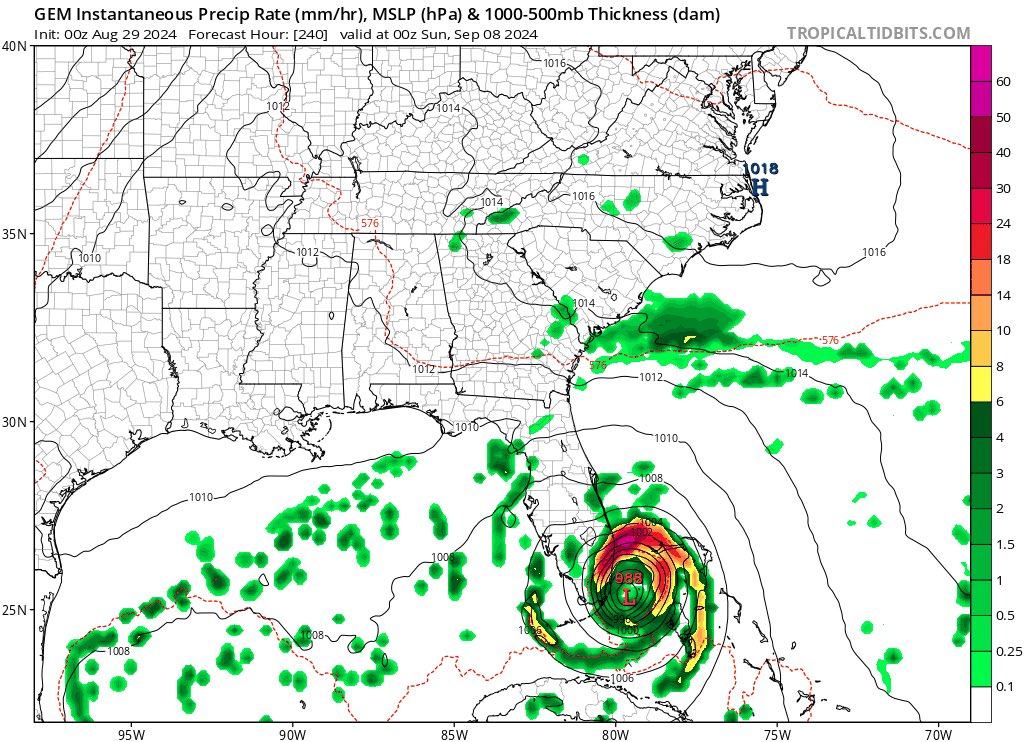
Edit: Major hurricane in the Caribbean this run. Near Cuba. If the system can avoid land interaction (big if) the ceiling appears quite high...

Edit: Major hurricane in the Caribbean this run. Near Cuba. If the system can avoid land interaction (big if) the ceiling appears quite high...
3 likes
Kendall -> SLO -> PBC
Memorable Storms: Katrina (for its Florida landfall...) Wilma Matthew Irma
Memorable Storms: Katrina (for its Florida landfall...) Wilma Matthew Irma
Who is online
Users browsing this forum: Ulf and 111 guests