Cachondo23 wrote:Do we currently have a strong High Pressure therefore almost every model keep it going west?
There will be an escape hatch east of the US if this strengthens sooner. Best chance for a US landfall is delayed development until Jamaica
Moderator: S2k Moderators


Cachondo23 wrote:Do we currently have a strong High Pressure therefore almost every model keep it going west?

Ivanhater wrote:Cachondo23 wrote:Do we currently have a strong High Pressure therefore almost every model keep it going west?
There will be an escape hatch east of the US if this strengthens sooner. Best chance for a US landfall is delayed development until Jamaica
SFLcane wrote:Cachondo23 wrote:Do we currently have a strong High Pressure therefore almost every model keep it going west?
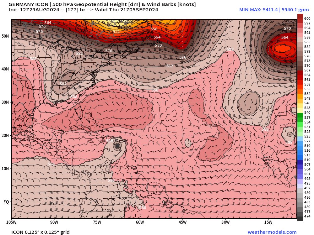
https://i.postimg.cc/Wbgpnr5N/nnn.jpg
otowntiger wrote:SFLcane wrote:Cachondo23 wrote:Do we currently have a strong High Pressure therefore almost every model keep it going west?
https://i.postimg.cc/Wbgpnr5N/nnn.jpg
Unless I’m reading that map incorrectly it would seem to me that is a set up to make it plow right into CA/Mex, right?
Ivanhater wrote:otowntiger wrote:SFLcane wrote:
https://i.postimg.cc/Wbgpnr5N/nnn.jpg
Unless I’m reading that map incorrectly it would seem to me that is a set up to make it plow right into CA/Mex, right?
There is a trough coming that will break down the ridge.
Ubuntwo wrote:So far, the 12z GFS appears to string out the wave envelope and does not yet have a compact vort coming together unlike the 0z/6z.
Ivanhater wrote:12Z GFS drops it
MarioProtVI wrote:Ubuntwo wrote:So far, the 12z GFS appears to string out the wave envelope and does not yet have a compact vort coming together unlike the 0z/6z.
GFS bias in full effect (windshield wiper + bias to string out vorticity repeatedly)
Ivanhater wrote:12Z GFS drops it


SouthFLTropics wrote:So ICON still has it and the GFS can't make up its mind and is doing GFS things. So far, looks like the CMC is still developing it as well. Seeing the ensembles as well as this afternoon's Euro operational will be interesting.
Teban54 wrote:SouthFLTropics wrote:So ICON still has it and the GFS can't make up its mind and is doing GFS things. So far, looks like the CMC is still developing it as well. Seeing the ensembles as well as this afternoon's Euro operational will be interesting.
FWIW, 12z GEFS is also much less active, but that shouldn't be surprising given the operational. There may also be a logical way to explain both that and the fact that GEFS wasn't more active than EPS last night: If the operational GFS is prone to making the waves more strung out than other models do, the same can be expected of GEFS. I'm not sure if this tells us anything one way or another... Better wait for the Euro runs and 18z.
Meanwhile, CMC's Lesser Antilles landfall is more organized and slightly stronger (by 1mb) than the last run.


SFLcane wrote:wxman57 whats your take on a 64 Cleo analog for this AOI?
Users browsing this forum: Iceresistance and 100 guests


