Area of disturbed weather in NW Gulf of Mexico (Is Invest 90L)
Moderator: S2k Moderators
Forum rules

The posts in this forum are NOT official forecasts and should not be used as such. They are just the opinion of the poster and may or may not be backed by sound meteorological data. They are NOT endorsed by any professional institution or STORM2K. For official information, please refer to products from the National Hurricane Center and National Weather Service.

Re: Area of disturbed weather in western Gulf of Mexico
I think it’s a middle level feature. I’ve been in New Orleans this week and they’ve had an incredibly hot August with most days into the mid to upper 90’s with lots of heat advisories and warnings. Today we’ve had a lot of wrap around thunderstorms - probably 5 so far - throughout the day. I’ll take it. Again ICON progged it last weekend but it hasn’t developed and it’s since backed off. If nothing else besides taking the heat away for a while it should do some work on the northwestern gulf water too. We all know that it doesn’t take named storms to do the work of balancing the heat
3 likes
-
cycloneye

- Admin

- Posts: 149261
- Age: 69
- Joined: Thu Oct 10, 2002 10:54 am
- Location: San Juan, Puerto Rico
Re: Area of disturbed weather in western Gulf of Mexico
No mention of this area on the 8 PM TWO.
1 likes
Visit the Caribbean-Central America Weather Thread where you can find at first post web cams,radars
and observations from Caribbean basin members Click Here
and observations from Caribbean basin members Click Here

Re: Area of disturbed weather in western Gulf of Mexico
cycloneye wrote:No mention of this area on the 8 PM TWO.
Surface pressures are falling tonight right along the Texas coast, several buoy readings down to 29.83.
Maybe NHC thinks this will move west inland and dissipate in the desert?
1 likes
-
tropicwatch

- Category 5

- Posts: 3426
- Age: 62
- Joined: Sat Jun 02, 2007 10:01 am
- Location: Panama City Florida
- Contact:
Re: Area of disturbed weather in western Gulf of Mexico
Vorticity will need to pick up closer to the surface before the NHC gives a lemon. imo
1 likes
Tropicwatch
Agnes 72', Eloise 75, Elena 85', Kate 85', Charley 86', Florence 88', Beryl 94', Dean 95', Erin 95', Opal 95', Earl 98', Georges 98', Ivan 2004', Arlene 2005', Dennis 2005', Ida 2009' Debby 2012' Irma 2017' Michael 2018'
Agnes 72', Eloise 75, Elena 85', Kate 85', Charley 86', Florence 88', Beryl 94', Dean 95', Erin 95', Opal 95', Earl 98', Georges 98', Ivan 2004', Arlene 2005', Dennis 2005', Ida 2009' Debby 2012' Irma 2017' Michael 2018'
Re: Area of disturbed weather in western Gulf of Mexico
tropicwatch wrote:Vorticity will need to pick up closer to the surface before the NHC gives a lemon. imo
I agree. I haven’t felt like looking at the mid and upper charts yet, so I’m going off the assumption this is a mid level feature where the one that went into Texas a few days ago was upper level energy. I don’t think it follows the track of the backing west upper low. Either the energy remains mostly disorganized at the surface (at least a few days) and stays in the Gulf or moves north into eastern Texas remains to be seen.
2 likes
-
Stratton23
- Category 5
- Posts: 3517
- Joined: Fri Jul 21, 2023 10:59 pm
- Location: Katy, Tx
Re: Area of disturbed weather in western Gulf of Mexico
the mesocales seem to think that the vorticity will stall out and not move in land, thats why more of them are developing a weak but closed circulation because the energy remains over water longer
18z ICON brings back a weak closed low
18z ICON brings back a weak closed low
0 likes

Re: Area of disturbed weather in western Gulf of Mexico
tropicwatch wrote:Vorticity will need to pick up closer to the surface before the NHC gives a lemon. imo
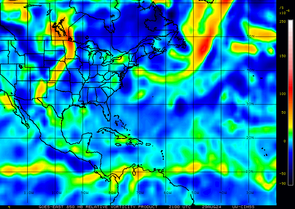
Actually, there's now significant vorticity building up at 850 mb in the past 3-4 hours, and the difference between 21z and 0z is night and day. The vort signature isn't as strong at 925 mb, though, so we'll see if there's more convection to bring it down. Right now the disturbance is pretty anemic in convection, but it was just past DMIN.
Last edited by Teban54 on Thu Aug 29, 2024 9:19 pm, edited 1 time in total.
1 likes
TC naming lists: retirements and intensity
Most aggressive Advisory #1's in North Atlantic (cr. kevin for starting the list)
Most aggressive Advisory #1's in North Atlantic (cr. kevin for starting the list)
-
tropicwatch
- Category 5
- Posts: 3426
- Age: 62
- Joined: Sat Jun 02, 2007 10:01 am
- Location: Panama City Florida
- Contact:
Re: Area of disturbed weather in western Gulf of Mexico
Very nice, I posted before the 7pm vorticity was available. Might get a lemon at the next TWO but I hope to be asleep by then. The convection has waned quite a bit. So maybe no lemon 
0 likes
Tropicwatch
Agnes 72', Eloise 75, Elena 85', Kate 85', Charley 86', Florence 88', Beryl 94', Dean 95', Erin 95', Opal 95', Earl 98', Georges 98', Ivan 2004', Arlene 2005', Dennis 2005', Ida 2009' Debby 2012' Irma 2017' Michael 2018'
Agnes 72', Eloise 75, Elena 85', Kate 85', Charley 86', Florence 88', Beryl 94', Dean 95', Erin 95', Opal 95', Earl 98', Georges 98', Ivan 2004', Arlene 2005', Dennis 2005', Ida 2009' Debby 2012' Irma 2017' Michael 2018'
-
Stratton23
- Category 5
- Posts: 3517
- Joined: Fri Jul 21, 2023 10:59 pm
- Location: Katy, Tx
Re: Area of disturbed weather in western Gulf of Mexico
personally based on the mesocale guidance, and a slight uptick in the 18z GEFS, I would give this a 0/10% in my opinion, its at least worth watching, i remember global models werent really enthused about imelda forming from an area of low pressure similarly like this one
0 likes
-
Stratton23
- Category 5
- Posts: 3517
- Joined: Fri Jul 21, 2023 10:59 pm
- Location: Katy, Tx
Re: Area of disturbed weather in western Gulf of Mexico
00z ICON has a TS that slowly rides offshore of the texas coast towards far SW lousiana, producing some insane rains over the gulf
0 likes
-
Category5Kaiju

- Category 5
- Posts: 4330
- Joined: Thu Dec 24, 2020 12:45 pm
- Location: Seattle and Phoenix
Re: Area of disturbed weather in western Gulf of Mexico
Not sure if it's this particular system per se, but the ICON seems very adamant about this becoming a TC. Doesn't have much model support otherwise though, which is interesting.
0 likes
Unless explicitly stated, all info in my posts is based on my own opinions and observations. Tropical storms and hurricanes can be extremely dangerous. Refer to an accredited weather research agency or meteorologist if you need to make serious decisions regarding an approaching storm.
-
HurricaneBrain

- S2K Supporter

- Posts: 520
- Joined: Thu Jun 30, 2011 2:07 pm
Re: Area of disturbed weather in western Gulf of Mexico
The potential is there for a TD to develop from this. Very odd to see the NHC not give this a chance whatsoever. I’d go on a limb and say this has a 40% chance of developing. Just my opinion.
0 likes
-
tropicwatch
- Category 5
- Posts: 3426
- Age: 62
- Joined: Sat Jun 02, 2007 10:01 am
- Location: Panama City Florida
- Contact:
Re: Area of disturbed weather in western Gulf of Mexico
HurricaneBrain wrote:The potential is there for a TD to develop from this. Very odd to see the NHC not give this a chance whatsoever. I’d go on a limb and say this has a 40% chance of developing. Just my opinion.
Well there is very little convection over the gulf and all the moisture is moving inland.
0 likes
Tropicwatch
Agnes 72', Eloise 75, Elena 85', Kate 85', Charley 86', Florence 88', Beryl 94', Dean 95', Erin 95', Opal 95', Earl 98', Georges 98', Ivan 2004', Arlene 2005', Dennis 2005', Ida 2009' Debby 2012' Irma 2017' Michael 2018'
Agnes 72', Eloise 75, Elena 85', Kate 85', Charley 86', Florence 88', Beryl 94', Dean 95', Erin 95', Opal 95', Earl 98', Georges 98', Ivan 2004', Arlene 2005', Dennis 2005', Ida 2009' Debby 2012' Irma 2017' Michael 2018'
-
TomballEd
- Category 5
- Posts: 1261
- Age: 62
- Joined: Wed Aug 16, 2023 4:52 pm
- Location: Spring/Klein area, not Tomball
Re: Area of disturbed weather in western Gulf of Mexico
It doesn't need a lemon. It has finally started drilling down to the surface, but it is partially onshore in Texas already looking at CIMMS vorticity. Only the ICON tries to develop it. Ensemble support for a TD or weak TS looks fairly weak.
Still worth watching, if it can drift 100 miles S/SE and get entirely over water, it'd have warm water, decent shear, and it is finally drilling down to the surface. If models change tune and move it offshore, or NHC sees it drifting back offshore, it could get a lemon. Maybe even an orange. But it seems unlikely. But we watch.
The50% 40% AOI is the best chance for a TC in the Gulf. Not a certainty, the early developers on the ensembles curve N through the Greater Antilles, but some do get into the Gulf.
Still worth watching, if it can drift 100 miles S/SE and get entirely over water, it'd have warm water, decent shear, and it is finally drilling down to the surface. If models change tune and move it offshore, or NHC sees it drifting back offshore, it could get a lemon. Maybe even an orange. But it seems unlikely. But we watch.
The
2 likes
Re: Area of disturbed weather in western Gulf of Mexico
https://www.tropicaltidbits.com/sat/sat ... t=vis_swir
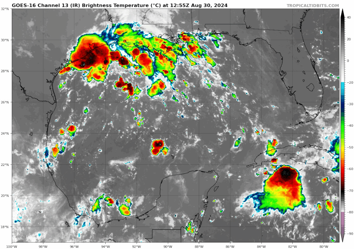
Bubbling. New Orleans is under an outflow band at the moment and have a flood advisory out until 11:30am (at 8:30am Doppler indicated heavy rain. Minor flooding is expected to begin shortly. Rainfall amounts of 1-3" expected over the area.) I assume this will become a flash flood warning if the band stays parked. It's been gradually moving NE but hopefully there will be a break between bands.
https://radar.weather.gov/station/KHDC/standard
Edit - as expected, it's now a flash flood warning across metro New Orleans going out until 12:15pm. "At 9:12am radar indicated thunderstorms producing heavy rain. Between 1 - 1.5" have fallen. The expected rainfall rate is 1-4" in 1 hour. Additional rainfall of 1-3" is possible."
0 likes
-
Stratton23
- Category 5
- Posts: 3517
- Joined: Fri Jul 21, 2023 10:59 pm
- Location: Katy, Tx
Re: Area of disturbed weather in western Gulf of Mexico
TomballEd almost all of the mesocale models keep this over water and develop a weak closed low, it has more support than you think lol
0 likes
Re: Area of disturbed weather in western Gulf of Mexico
Stratton23 wrote:TomballEd almost all of the mesocale models keep this over water and develop a weak closed low, it has more support than you think lol
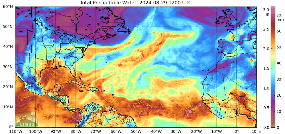
They do. ICON develops it, drops it south a little then comes back in around Morgan City, LA before riding the coast toward the Panhandle. Pressure doesn't ever depict to being all that low at the surface (like 1009mb) though it might be too small of a feature. It's what's coming out of the Caribbean (assuming Central Atlantic Wave discussion) that looks like the big dog in this setup. Here's the 7 day QPF Total. Much of that is likely to be underdone since New Orleans is shown to have 3-4" of rain, and it's already gotten about 2" so far today.

Also LOL at NAM 3km going for the 1001mb
Last edited by Steve on Fri Aug 30, 2024 11:08 am, edited 1 time in total.
0 likes
Re: Area of disturbed weather in western Gulf of Mexico
From the NBDC:
Station 42035 (29.235N 94.41W - 22 nautical miles east of Galveston) NNE Winds at 3.9 gusting to 5.8 with pressure 29.96 and water temp of 86.2
Station KGVW (FAA) at 29.13N 94.55W has East winds at 11.1k
Most of the other reporting stations of the TX Coast are running 29.96/29.97 where FWL1/Freshwater Canal Locks off the LA Coast shows 30.15. Though 29.96 isn't low at all, it's low compared to a station not all that far away to its east.
0 likes
-
cycloneye
- Admin
- Posts: 149261
- Age: 69
- Joined: Thu Oct 10, 2002 10:54 am
- Location: San Juan, Puerto Rico
Re: Area of disturbed weather in NW Gulf of Mexico (10/20)
Northwestern Gulf of Mexico:
A surface trough of low pressure over the northwestern Gulf of
Mexico is producing a large area of disorganized showers and
thunderstorms along and just offshore the coasts of Texas and
Louisiana. This system is expected to meander near the coast
through much of next week, and some slow development is possible if
it remains offshore. Regardless of development, heavy rains could
cause some flash flooding across portions of coastal Louisiana and
the upper Texas coast during the next few days.
* Formation chance through 48 hours...low...10 percent.
* Formation chance through 7 days...low...20 percent.

1 likes
Visit the Caribbean-Central America Weather Thread where you can find at first post web cams,radars
and observations from Caribbean basin members Click Here
and observations from Caribbean basin members Click Here
Re: Area of disturbed weather in NW Gulf of Mexico (10/20)
cycloneye wrote:Northwestern Gulf of Mexico:
A surface trough of low pressure over the northwestern Gulf of
Mexico is producing a large area of disorganized showers and
thunderstorms along and just offshore the coasts of Texas and
Louisiana. This system is expected to meander near the coast
through much of next week, and some slow development is possible if
it remains offshore. Regardless of development, heavy rains could
cause some flash flooding across portions of coastal Louisiana and
the upper Texas coast during the next few days.
* Formation chance through 48 hours...low...10 percent.
* Formation chance through 7 days...low...20 percent.
https://i.imgur.com/kl5ngnx.png
The recent blowup in convection likely contributed to the newly highlighted lemon:
1 likes
TC naming lists: retirements and intensity
Most aggressive Advisory #1's in North Atlantic (cr. kevin for starting the list)
Most aggressive Advisory #1's in North Atlantic (cr. kevin for starting the list)
Who is online
Users browsing this forum: ljmac75 and 158 guests