Tropical Wave in Bay of Campeche (Is Invest 91L)

This is the general tropical discussion area. Anyone can take their shot at predicting a storms path.

Moderator: S2k Moderators

Forum rules

The posts in this forum are NOT official forecasts and should not be used as such. They are just the opinion of the poster and may or may not be backed by sound meteorological data. They are NOT endorsed by any professional institution or STORM2K. For official information, please refer to products from the National Hurricane Center and National Weather Service.

Help Support Storm2K
Message
Author
BobHarlem
Category 5
Category 5
Posts: 2034
Joined: Thu Oct 20, 2005 6:11 pm

Re: Tropical Wave in Central Atlantic (0/40)

#381 Postby BobHarlem » Fri Aug 30, 2024 10:31 am

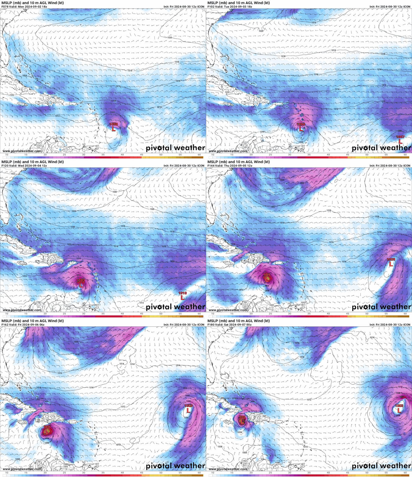
Final frame of 12z icon:

Clips west side (Tiburon Peninsula) of Haiti.
Image

0z was way west, 12z yesterday was east of today's 12z.
0 likes   

User avatar
SFLcane
S2K Supporter
S2K Supporter
Posts: 10162
Age: 47
Joined: Sat Jun 05, 2010 1:44 pm
Location: Lake Worth Florida

Re: Tropical Wave in Central Atlantic (0/40)

#382 Postby SFLcane » Fri Aug 30, 2024 10:35 am

12z icon more north heading wnw-nw at the end of the run.

Image
0 likes   

User avatar
chaser1
S2K Supporter
S2K Supporter
Posts: 5407
Age: 64
Joined: Sat Oct 15, 2005 5:59 pm
Location: Longwood, Fl

Re: Tropical Wave in Central Atlantic (0/40)

#383 Postby chaser1 » Fri Aug 30, 2024 10:37 am

cheezyWXguy wrote:Trying to figure out if the reduction in chances is due to decreased likelihood of development at all, or a higher likelihood that development would occur (should it occur) beyond the 7 day period. Aside from the early-bird icon, I don’t recall much support for formation until this thing is nearing Jamaica. GFS, GEFS, and CMC have been inconsistent for a while now, so I don’t see much of a notable decrease in model support compared to yesterday.


My guess is that NHC was influenced by 3 consecutive runs of the ICON along with perhaps a nominal degree of support by EIFS, but then with the ICON beginning to back off of development in concert with the degraded concentration of convection per satellite presentation, they simply backed off a tad. I agree with Cycloneye that there is no doubt at least one or two areas of spin with that area from 47W - 50 W (and perhaps one more a bit east of there). Overall it seems conditions overall are adequate for development but that clearly may not be clear.
0 likes   
Andy D

(For official information, please refer to the NHC and NWS products.)

User avatar
chaser1
S2K Supporter
S2K Supporter
Posts: 5407
Age: 64
Joined: Sat Oct 15, 2005 5:59 pm
Location: Longwood, Fl

Re: Tropical Wave in Central Atlantic (0/40)

#384 Postby chaser1 » Fri Aug 30, 2024 10:39 am

Funny, no sooner did I finish writing my last post here did I then notice SFLcane's post and graphic of the ICON's 12Z run showing its back on the development train LOL.
0 likes   
Andy D

(For official information, please refer to the NHC and NWS products.)

User avatar
Ubuntwo
Category 5
Category 5
Posts: 1401
Age: 31
Joined: Thu Oct 05, 2017 10:41 pm

Re: Tropical Wave in Central Atlantic (0/40)

#385 Postby Ubuntwo » Fri Aug 30, 2024 10:40 am

chaser1 wrote:
cheezyWXguy wrote:Trying to figure out if the reduction in chances is due to decreased likelihood of development at all, or a higher likelihood that development would occur (should it occur) beyond the 7 day period. Aside from the early-bird icon, I don’t recall much support for formation until this thing is nearing Jamaica. GFS, GEFS, and CMC have been inconsistent for a while now, so I don’t see much of a notable decrease in model support compared to yesterday.

Generally, the formation odds are driven by ensemble density more than operational models developing/not. EPS yesterday had nearly 70% developing while GEFS was in the 30-40% range, so 50% was a natural compromise. As of the 0z/6z those dropped by about 10% each.
1 likes   
Kendall -> SLO -> PBC

Memorable Storms: Katrina (for its Florida landfall...) Wilma Matthew Irma

User avatar
Ubuntwo
Category 5
Category 5
Posts: 1401
Age: 31
Joined: Thu Oct 05, 2017 10:41 pm

Re: Tropical Wave in Central Atlantic (0/40)

#386 Postby Ubuntwo » Fri Aug 30, 2024 10:52 am

12z GFS is back to a quick roll up scenario with vorticity concentrating in a matter of 24-36 hours, although no development just yet. This has to be one of the more difficult-to-forecast wave TCG cases of the past half decade.
1 likes   
Kendall -> SLO -> PBC

Memorable Storms: Katrina (for its Florida landfall...) Wilma Matthew Irma

User avatar
Hypercane_Kyle
Category 5
Category 5
Posts: 3344
Joined: Sat Mar 07, 2015 7:58 pm
Location: Cape Canaveral, FL

Re: Tropical Wave in Central Atlantic (0/40)

#387 Postby Hypercane_Kyle » Fri Aug 30, 2024 11:11 am

12z Canadian coming in with a weak low by Tuesday afternoon.
0 likes   
My posts are my own personal opinion, defer to the National Hurricane Center (NHC) and other NOAA products for decision making during hurricane season.

User avatar
Hurricaneman
Category 5
Category 5
Posts: 7349
Age: 44
Joined: Tue Aug 31, 2004 3:24 pm
Location: central florida

Re: Tropical Wave in Central Atlantic (0/40)

#388 Postby Hurricaneman » Fri Aug 30, 2024 11:12 am

Ubuntwo wrote:12z GFS is back to a quick roll up scenario with vorticity concentrating in a matter of 24-36 hours, although no development just yet. This has to be one of the more difficult-to-forecast wave TCG cases of the past half decade.

Indeed, this could be something that never develops due to too much going on or it could be a cat 5 in the GOM or Yucatán so no scenario can be left off the table
1 likes   

User avatar
chaser1
S2K Supporter
S2K Supporter
Posts: 5407
Age: 64
Joined: Sat Oct 15, 2005 5:59 pm
Location: Longwood, Fl

Re: Tropical Wave in Central Atlantic (0/40)

#389 Postby chaser1 » Fri Aug 30, 2024 11:13 am

Ubuntwo wrote:
chaser1 wrote:
cheezyWXguy wrote:Trying to figure out if the reduction in chances is due to decreased likelihood of development at all, or a higher likelihood that development would occur (should it occur) beyond the 7 day period. Aside from the early-bird icon, I don’t recall much support for formation until this thing is nearing Jamaica. GFS, GEFS, and CMC have been inconsistent for a while now, so I don’t see much of a notable decrease in model support compared to yesterday.

Generally, the formation odds are driven by ensemble density more than operational models developing/not. EPS yesterday had nearly 70% developing while GEFS was in the 30-40% range, so 50% was a natural compromise. As of the 0z/6z those dropped by about 10% each.


Well yes, in any normal year. Anyone can show me a net increase in ensemble activity but if that ensemble activity is broadly spread out over significant breadth of distance, that implies significant steering discrepancies among the different levels ultimately disruptive to any undeveloped core in its attempt to establish a vertical structure. Additionally, an established run to run increase in ensemble activity should be some indication but I am a little skeptical of anointing impending development simply based on that if/where the point of genesis appears inconsistent or bounces around suggestive of multiple areas of vorticity and potentially environmental conditions that simple mitigate any one COC from occurring. Put simply, I really see the ensembles increase and wane as a reflection of some marginal conditions that remains difficult to clearly identify. When it comes down to it NHC would logically view ensemble activity over operational model output in determining likelihood of development, but in the end are not doing so in a vacuum given satellite presentation and persistence.
0 likes   
Andy D

(For official information, please refer to the NHC and NWS products.)

User avatar
Teban54
Category 5
Category 5
Posts: 3168
Joined: Sat May 19, 2018 1:19 pm

Re: Tropical Wave in Central Atlantic (0/40)

#390 Postby Teban54 » Fri Aug 30, 2024 11:14 am

Ubuntwo wrote:12z GFS is back to a quick roll up scenario with vorticity concentrating in a matter of 24-36 hours, although no development just yet. This has to be one of the more difficult-to-forecast wave TCG cases of the past half decade.

And yet, despite a nice concentration of vorticity at 60 hrs compared to the earlier developing runs like 0z and 6z 8/29 (with even better 500mb vorticity)... This run still keeps the wave weak as it enters and traverses through half of the Caribbean. 12z CMC, despite having a much better organized system than GFS entering the Caribbean, is also massively downtrending in intensity within the Caribbean, now showing a TS south of Jamaica instead of a hurricane.

The question is, why? This GFS run (and some other recent runs) seems to move the wave at a faster pace than the early 8/29 runs. Could it be the fast forward speed preventing early organization? Or something else?

Edit: I also think that the Eastern Atlantic situation on recent model runs is just as much of a head-scratcher, as no models made up their mind on which one of the at least two waves they want to develop. It gets less attention probably due to having no land impacts, and the unlikelihood of getting strong as per operational runs.
0 likes   

User avatar
chaser1
S2K Supporter
S2K Supporter
Posts: 5407
Age: 64
Joined: Sat Oct 15, 2005 5:59 pm
Location: Longwood, Fl

Re: Tropical Wave in Central Atlantic (0/40)

#391 Postby chaser1 » Fri Aug 30, 2024 11:23 am

Quite the contradiction between 12Z ICON and GFS runs. Unless the EURO suggests increasing near term development, then my guess strongly leans toward an GFS near to midterm genesis outcome.
0 likes   
Andy D

(For official information, please refer to the NHC and NWS products.)

User avatar
Teban54
Category 5
Category 5
Posts: 3168
Joined: Sat May 19, 2018 1:19 pm

Re: Tropical Wave in Central Atlantic (0/40)

#392 Postby Teban54 » Fri Aug 30, 2024 11:26 am

chaser1 wrote:Quite the contradiction between 12Z ICON and GFS runs. Unless the EURO suggests increasing near term development, then my guess strongly leans toward an GFS near to midterm genesis outcome.

To be fair, 6z Euro did suggest a more organized system in the short term (Lesser Antilles) than 0z Euro. The increase in short-term organization is also evident on 12z CMC compared to 0z, and 12z GFS compared to 6z, even though the latter is not organized enough for quick formation. That said, the most recent 6z and 18z Euro runs are both more optimistic than 0z and 12z, so it could be the 6z/18z bias.
0 likes   

otowntiger
Category 5
Category 5
Posts: 1921
Joined: Tue Aug 31, 2004 7:06 pm

Re: Tropical Wave in Central Atlantic (0/40)

#393 Postby otowntiger » Fri Aug 30, 2024 11:29 am

SFLcane wrote:12z icon more north heading wnw-nw at the end of the run.

https://i.postimg.cc/vBtKJcnV/bbb.gif
looks like it will recurve from that spot.
0 likes   

BobHarlem
Category 5
Category 5
Posts: 2034
Joined: Thu Oct 20, 2005 6:11 pm

Re: Tropical Wave in Central Atlantic (0/40)

#394 Postby BobHarlem » Fri Aug 30, 2024 11:31 am

12z CMC goes right into the Belize/Mexico border and gets fairly strong before it does.
0 likes   

User avatar
drezee
S2K Supporter
S2K Supporter
Posts: 3664
Joined: Mon Jun 09, 2003 12:49 pm
Location: FL

Re: Tropical Wave in Central Atlantic (0/40)

#395 Postby drezee » Fri Aug 30, 2024 11:35 am

0 likes   

User avatar
toad strangler
S2K Supporter
S2K Supporter
Posts: 4543
Joined: Sun Jul 28, 2013 3:09 pm
Location: Earth
Contact:

Re: Tropical Wave in Central Atlantic (0/40)

#396 Postby toad strangler » Fri Aug 30, 2024 11:36 am

12z GFS OP says look out Ivanhater
0 likes   

User avatar
chaser1
S2K Supporter
S2K Supporter
Posts: 5407
Age: 64
Joined: Sat Oct 15, 2005 5:59 pm
Location: Longwood, Fl

Re: Tropical Wave in Central Atlantic (0/40)

#397 Postby chaser1 » Fri Aug 30, 2024 11:37 am

Teban54 wrote:
Ubuntwo wrote:12z GFS is back to a quick roll up scenario with vorticity concentrating in a matter of 24-36 hours, although no development just yet. This has to be one of the more difficult-to-forecast wave TCG cases of the past half decade.

And yet, despite a nice concentration of vorticity at 60 hrs compared to the earlier developing runs like 0z and 6z 8/29 (with even better 500mb vorticity)... This run still keeps the wave weak as it enters and traverses through half of the Caribbean. 12z CMC, despite having a much better organized system than GFS entering the Caribbean, is also massively downtrending in intensity within the Caribbean, now showing a TS south of Jamaica instead of a hurricane.

The question is, why? This GFS run (and some other recent runs) seems to move the wave at a faster pace than the early 8/29 runs. Could it be the fast forward speed preventing early organization? Or something else?

Edit: I also think that the Eastern Atlantic situation on recent model runs is just as much of a head-scratcher, as no models made up their mind on which one of the at least two waves they want to develop. It gets less attention probably due to having no land impacts, and the unlikelihood of getting strong as per operational runs.


Thats a fact! So while many of us here are grappling with figuring out this season some have suggested a relationship to a long standing African monsoonal low. Meanwhile, here we are now looking at a Central/West Atlantic viable ITCZ flareup and disturbances within that for the moment is also seemingly struggling to organize. Sub tropics - nada. GOM flare-ups near Texas or Florida meh. Maybe a heavily backloaded end of September/October? Perhaps. Maybe the tropics discovers the magic sauce during November instead :roll:
0 likes   
Andy D

(For official information, please refer to the NHC and NWS products.)

BobHarlem
Category 5
Category 5
Posts: 2034
Joined: Thu Oct 20, 2005 6:11 pm

Re: Tropical Wave in Central Atlantic (0/40)

#398 Postby BobHarlem » Fri Aug 30, 2024 11:45 am

12z GFS back in the gulf with a major

Image

Image
0 likes   

User avatar
toad strangler
S2K Supporter
S2K Supporter
Posts: 4543
Joined: Sun Jul 28, 2013 3:09 pm
Location: Earth
Contact:

Re: Tropical Wave in Central Atlantic (0/40)

#399 Postby toad strangler » Fri Aug 30, 2024 11:47 am

12z GFS OP landfalls Way out in fantasy land of about 11 days near Apalachicola as a major hurricane. FSU wouldn’t like this scenario either being right front quadded.
0 likes   

USTropics
Category 5
Category 5
Posts: 2635
Joined: Sun Aug 12, 2007 3:45 am
Location: Florida State University

Re: Tropical Wave in Central Atlantic (0/40)

#400 Postby USTropics » Fri Aug 30, 2024 11:50 am

I've denoted the low-level cloud deck flow (green) within our monsoonal trough (which shows at least three low level vort lobes) as well as a rough outline of the tropical wave axis (pink) and the mid-level rotation behind our wave axis (orange).

Image

The CMC initial analysis does a decent job of capturing this, I would expect some type of consolidation process in the next 24-48 hours (even if the low-level vort remains weak):
Image
7 likes   


Return to “Talkin' Tropics”

Who is online

Users browsing this forum: No registered users and 943 guests