Tropical Wave in Bay of Campeche (Is Invest 91L)
Moderator: S2k Moderators
Forum rules
The posts in this forum are NOT official forecasts and should not be used as such. They are just the opinion of the poster and may or may not be backed by sound meteorological data. They are NOT endorsed by any professional institution or STORM2K. For official information, please refer to products from the National Hurricane Center and National Weather Service.
-
hurricane2025
- Category 1

- Posts: 254
- Joined: Thu Apr 08, 2021 10:36 am
Re: Tropical Wave in Central Atlantic (0/40)
If I was a betting man there won’t be a cold front like that to make a NE turn like that lol
0 likes
- Ivanhater
- Storm2k Moderator

- Posts: 11222
- Age: 39
- Joined: Fri Jul 01, 2005 8:25 am
- Location: Pensacola
Re: Tropical Wave in Central Atlantic (0/40)
hurricane2025 wrote:If I was a betting man there won’t be as cold front like that to make a nee turn like that lol
Would be a very common track for September. It doesn't need to be a strong cold front. Just enough to erode the western periphery of the ridge. If it does indeed strengthen and sees a weakness in the Gulf, the Euro would be a classic early September track
2 likes
Michael
-
hurricane2025
- Category 1

- Posts: 254
- Joined: Thu Apr 08, 2021 10:36 am
Re: Tropical Wave in Central Atlantic (0/40)
That’s not a very common track pushing NE in early Sept lol with how the pattern is
0 likes
- Ivanhater
- Storm2k Moderator

- Posts: 11222
- Age: 39
- Joined: Fri Jul 01, 2005 8:25 am
- Location: Pensacola
Re: Tropical Wave in Central Atlantic (0/40)
Are you talking about the Euro? It's not pushing NE, it's feeling the weakness over the northern Gulf Coast. Not a strong cold front sweeping it NE, just a weakness. Very common occurrence. Remains to be seen if that actually happens but to say that it is not a classic track would be incorrect

Sent from my motorola razr plus 2023 using Tapatalk

Sent from my motorola razr plus 2023 using Tapatalk
6 likes
Michael
- Ivanhater
- Storm2k Moderator

- Posts: 11222
- Age: 39
- Joined: Fri Jul 01, 2005 8:25 am
- Location: Pensacola
Re: Tropical Wave in Central Atlantic (0/50)
There is a clear weakness on the 06z GFS but the system never gets going until after the Yucatan. It moves north towards Texas.
There won't be a blocking high protecting the Gulf, but a trough opening a weakness over the entire Gulf coast.
If the models are missing this strengthening sooner, it will move north like the Euro shows into the weakness
There won't be a blocking high protecting the Gulf, but a trough opening a weakness over the entire Gulf coast.
If the models are missing this strengthening sooner, it will move north like the Euro shows into the weakness
0 likes
Michael
- gatorcane
- S2K Supporter

- Posts: 23708
- Age: 48
- Joined: Sun Mar 13, 2005 3:54 pm
- Location: Boca Raton, FL
Re: Tropical Wave in Central Atlantic (0/50)
Ivanhater wrote:There is a clear weakness on the 06z GFS but the system never gets going until after the Yucatan. It moves north towards Texas.
There won't be a blocking high protecting the Gulf, but a trough opening a weakness over the entire Gulf coast.
If the models are missing this strengthening sooner, it will move north like the Euro shows into the weakness
The 00Z Euro is quite a bit faster than the GFS by day 7 when the system is over the NW Caribbean, allowing it to turn north into the weakness before ridging builds back in over the Gulf and Florida.
0 likes
- Hypercane_Kyle
- Category 5

- Posts: 3465
- Joined: Sat Mar 07, 2015 7:58 pm
- Location: Cape Canaveral, FL
Re: Tropical Wave in Central Atlantic (0/50)
As strong of a signal as you're likely to get this far out on the EPS.
Weird reality where the Euro is significantly more aggressive than the GFS at genesis.

Weird reality where the Euro is significantly more aggressive than the GFS at genesis.

1 likes
My posts are my own personal opinion, defer to the National Hurricane Center (NHC) and other NOAA products for decision making during hurricane season.
Re: Tropical Wave in Central Atlantic (0/50)
8AM:
A tropical wave located several hundred miles east of the Lesser
Antilles continues to produce some disorganized showers and
thunderstorms. The disturbance is forecast to move westward and
reach the Lesser Antilles on Monday. Thereafter, environmental
conditions appear conducive for gradual development of this system,
and a tropical depression could form while it continues moving
westward across the Caribbean Sea through the middle to latter part
of the week.
* Formation chance through 48 hours...low...near 0 percent.
* Formation chance through 7 days...medium...50 percent.
1 likes
-
DunedinDave
- Category 1

- Posts: 269
- Joined: Fri Aug 25, 2023 10:31 am
Re: Tropical Wave in Central Atlantic (0/50)
Feeling better here in Fla but nervous for people in Texas and Louisiana.
0 likes
- gatorcane
- S2K Supporter

- Posts: 23708
- Age: 48
- Joined: Sun Mar 13, 2005 3:54 pm
- Location: Boca Raton, FL
Re: Tropical Wave in Central Atlantic (0/50)
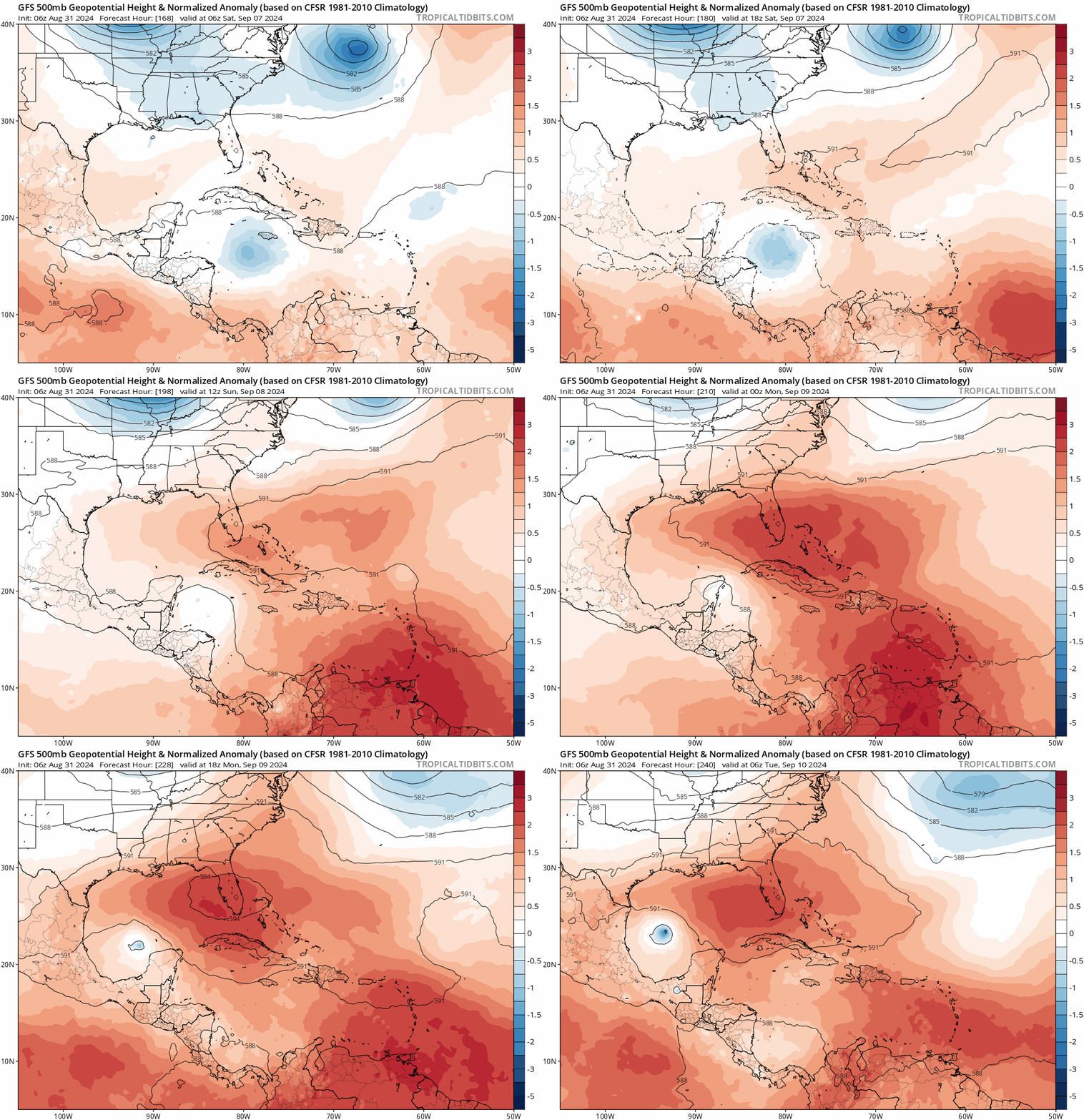
500MB heights forecast from the 06Z GFS showing a ridge building over Florida and the Gulf next weekend which drives the system west. That’s looking more like you would expect this time of year:


Last edited by gatorcane on Sat Aug 31, 2024 7:40 am, edited 1 time in total.
0 likes
-
hurricane2025
- Category 1

- Posts: 254
- Joined: Thu Apr 08, 2021 10:36 am
Re: Tropical Wave in Central Atlantic (0/50)
Ivanhater wrote:There is a clear weakness on the 06z GFS but the system never gets going until after the Yucatan. It moves north towards Texas.
There won't be a blocking high protecting the Gulf, but a trough opening a weakness over the entire Gulf coast.
If the models are missing this strengthening sooner, it will move north like the Euro shows into the weakness
Mjo is in phase 4 and 5 beryl setup
1 likes
-
otowntiger
- Category 5

- Posts: 1932
- Joined: Tue Aug 31, 2004 7:06 pm
Re: Tropical Wave in Central Atlantic (0/50)
DunedinDave wrote:Feeling better here in Fla but nervous for people in Texas and Louisiana.
It’s really too early to be ‘feeling’ one way or the other, honestly.
3 likes
-
hurricane2025
- Category 1

- Posts: 254
- Joined: Thu Apr 08, 2021 10:36 am
Re: Tropical Wave in Central Atlantic (0/50)
otowntiger wrote:DunedinDave wrote:Feeling better here in Fla but nervous for people in Texas and Louisiana.
It’s really too early to be ‘feeling’ one way or the other, honestly.
Mojo is in phase 4 and 5 this matters with the pattern/setup
1 likes
- LadyBug72
- Tropical Storm

- Posts: 121
- Joined: Mon Jun 01, 2020 3:39 pm
- Location: about 20 miles from Galveston, Tx
Re: Tropical Wave in Central Atlantic (0/50)
hurricane2025 wrote:Ivanhater wrote:There is a clear weakness on the 06z GFS but the system never gets going until after the Yucatan. It moves north towards Texas.
There won't be a blocking high protecting the Gulf, but a trough opening a weakness over the entire Gulf coast.
If the models are missing this strengthening sooner, it will move north like the Euro shows into the weakness
Mjo is in phase 4 and 5 beryl setup
Do you mind explaining the MJO phase? I’m still learning about this.
0 likes
Formerly known as the user: Nikki
Alicia 83, Allison 01, Rita 05, Ike 08, Harvey 17, Nicholas 21, Coastal Texas Derecho 24, Beryl 24
Alicia 83, Allison 01, Rita 05, Ike 08, Harvey 17, Nicholas 21, Coastal Texas Derecho 24, Beryl 24
-
hurricane2025
- Category 1

- Posts: 254
- Joined: Thu Apr 08, 2021 10:36 am
Re: Tropical Wave in Central Atlantic (0/50)
LadyBug72 wrote:hurricane2025 wrote:Ivanhater wrote:There is a clear weakness on the 06z GFS but the system never gets going until after the Yucatan. It moves north towards Texas.
There won't be a blocking high protecting the Gulf, but a trough opening a weakness over the entire Gulf coast.
If the models are missing this strengthening sooner, it will move north like the Euro shows into the weakness
Mjo is in phase 4 and 5 beryl setup
Do you mind explaining the MJO phase? I’m still learning about this.
http://www.climate.gov/news-features/bl ... do-we-care
4 likes
- LadyBug72
- Tropical Storm

- Posts: 121
- Joined: Mon Jun 01, 2020 3:39 pm
- Location: about 20 miles from Galveston, Tx
Re: Tropical Wave in Central Atlantic (0/50)
hurricane2025 wrote:LadyBug72 wrote:hurricane2025 wrote:
Mjo is in phase 4 and 5 beryl setup
Do you mind explaining the MJO phase? I’m still learning about this.
http://www.climate.gov/news-features/bl ... do-we-care
Thank you!
1 likes
Formerly known as the user: Nikki
Alicia 83, Allison 01, Rita 05, Ike 08, Harvey 17, Nicholas 21, Coastal Texas Derecho 24, Beryl 24
Alicia 83, Allison 01, Rita 05, Ike 08, Harvey 17, Nicholas 21, Coastal Texas Derecho 24, Beryl 24
-
otowntiger
- Category 5

- Posts: 1932
- Joined: Tue Aug 31, 2004 7:06 pm
Re: Tropical Wave in Central Atlantic (0/50)
hurricane2025 wrote:otowntiger wrote:DunedinDave wrote:Feeling better here in Fla but nervous for people in Texas and Louisiana.
It’s really too early to be ‘feeling’ one way or the other, honestly.
Mojo is in phase 4 and 5 this matters with the pattern/setup
I didn’t say that didn’t matter, but does that have anything to do with where the storm goes? That was the point of my comment.
0 likes
Re: Tropical Wave in Central Atlantic (0/40)
Ubuntwo wrote:cycloneye wrote:Around 51W there is more convection than the 47W turning but is dmin.
https://i.imgur.com/BM7wNrd.gif
This convection has spawned a little area of mid level/500mb spin. GFS and the Euro caught it on the latest runs. Is expected to persist overnight and die out going into Sunday. If convection does not move to the east, late development/no development becomes more likely.
For what it's worth, convection never focused on the eastern area as models expected. Convection has been somewhat linear but a little more concentrated than the last couple nights. This did end up amplifying the western areas of mid level spin more than expected (or the eastern area less than expected), which I believe is why models are even slower with development this morning.

This is still the best our wave has ever looked.

Last edited by Ubuntwo on Sat Aug 31, 2024 8:58 am, edited 1 time in total.
1 likes
Kendall -> SLO -> PBC
Memorable Storms: Katrina (for its Florida landfall...) Wilma Matthew Irma
Memorable Storms: Katrina (for its Florida landfall...) Wilma Matthew Irma
Re: Tropical Wave in Central Atlantic (0/50)
By hour 144, 50% of 6z EPS members develop vs. 59% on the 0z EPS at the same time. Far from a sure thing, but as with earlier, most developing members get quite strong.
1 likes
Kendall -> SLO -> PBC
Memorable Storms: Katrina (for its Florida landfall...) Wilma Matthew Irma
Memorable Storms: Katrina (for its Florida landfall...) Wilma Matthew Irma
Who is online
Users browsing this forum: gfsperpendicular and 177 guests


