Tropical Wave in Bay of Campeche (Is Invest 91L)

This is the general tropical discussion area. Anyone can take their shot at predicting a storms path.

Moderator: S2k Moderators

Forum rules

The posts in this forum are NOT official forecasts and should not be used as such. They are just the opinion of the poster and may or may not be backed by sound meteorological data. They are NOT endorsed by any professional institution or STORM2K. For official information, please refer to products from the National Hurricane Center and National Weather Service.

Help Support Storm2K
Message
Author
DunedinDave
Tropical Storm
Tropical Storm
Posts: 217
Joined: Fri Aug 25, 2023 10:31 am

Re: Tropical Wave in Central Atlantic (0/40)

#541 Postby DunedinDave » Sat Aug 31, 2024 9:00 am

hurricane2025 wrote:If I was a betting man there won’t be a cold front like that to make a NE turn like that lol


I don’t know. This could be one of those years where fronts start diving down early. The one coming in a few days is projected to make it down pretty deep. So much so the news agencies are covering it.

https://www.cnn.com/2024/08/30/weather/ ... index.html
0 likes   

txwxwatcher
Tropical Depression
Tropical Depression
Posts: 98
Joined: Thu Feb 18, 2010 10:00 pm

Re: Tropical Wave in Central Atlantic (0/40)

#542 Postby txwxwatcher » Sat Aug 31, 2024 9:05 am

DunedinDave wrote:
hurricane2025 wrote:If I was a betting man there won’t be a cold front like that to make a NE turn like that lol


I don’t know. This could be one of those years where fronts start diving down early. The one coming in a few days is projected to make it down pretty deep. So much so the news agencies are covering it.
https://www.cnn.com/2024/08/30/weather/ ... index.html


Exactly right. ABC13 in Houston is reporting that we may get down to the 60s next weekend with a front making its way through. That is unseasonably cool for this time of year.
0 likes   

User avatar
Kazmit
Category 5
Category 5
Posts: 2124
Age: 22
Joined: Mon Jul 25, 2016 8:49 am
Location: Williamsburg, VA / Bermuda

Re: Tropical Wave in Central Atlantic (0/40)

#543 Postby Kazmit » Sat Aug 31, 2024 9:07 am

hurricane2025 wrote:That’s not a very common track pushing NE in early Sept lol with how the pattern is

Ernesto started moving NE at an even lower latitude in mid-August.
0 likes   
Igor 2010, Sandy 2012, Fay 2014, Gonzalo 2014, Joaquin 2015, Nicole 2016, Humberto 2019

I am only a tropical weather enthusiast. My predictions are not official and may or may not be backed by sound meteorological data. For official information, please refer to the NHC and NWS products.

User avatar
Steve
S2K Supporter
S2K Supporter
Posts: 9591
Joined: Sat Apr 05, 2003 11:41 pm
Location: Not a state-caster

Re: Tropical Wave in Central Atlantic (0/50)

#544 Postby Steve » Sat Aug 31, 2024 9:09 am

otowntiger wrote:
hurricane2025 wrote:
otowntiger wrote:It’s really too early to be ‘feeling’ one way or the other, honestly.


Mojo is in phase 4 and 5 this matters with the pattern/setup

I didn’t say that didn’t matter, but does that have anything to do with where the storm goes? That was the point of my comment.


It’s hard to say what is cause and what is effect but there are correlations with phases and localized weather patterns where one would expect to see certain traits like strengthening/weakening at landfall, areas more likely to have systems and even the likelihood of storms at all. This article is very helpful to understanding MJO.

https://severeweather.wmo.int/TCFW/RAIV ... cBlake.pdf
0 likes   

User avatar
Ubuntwo
Category 5
Category 5
Posts: 1401
Age: 31
Joined: Thu Oct 05, 2017 10:41 pm

Re: Tropical Wave in Central Atlantic (0/50)

#545 Postby Ubuntwo » Sat Aug 31, 2024 9:12 am

hurricane2025 wrote:Mojo is in phase 4 and 5 this matters with the pattern/setup

MJO correlation with certain paths is quite weak, it is not by any means a predictor of track. It will never overpower short term synoptics.
2 likes   
Kendall -> SLO -> PBC

Memorable Storms: Katrina (for its Florida landfall...) Wilma Matthew Irma

hurricane2025
Tropical Storm
Tropical Storm
Posts: 206
Joined: Thu Apr 08, 2021 10:36 am

Re: Tropical Wave in Central Atlantic (0/50)

#546 Postby hurricane2025 » Sat Aug 31, 2024 9:37 am

Ubuntwo wrote:
hurricane2025 wrote:Mojo is in phase 4 and 5 this matters with the pattern/setup

MJO correlation with certain paths is quite weak, it is not by any means a predictor of track. It will never overpower short term synoptics.


https://x.com/bigjoebastardi/status/182 ... RUOsDj9WOg
1 likes   

MEANINGLESS_NUMBERS
Category 1
Category 1
Posts: 325
Joined: Mon Nov 02, 2020 1:43 pm

Re: Tropical Wave in Central Atlantic (0/50)

#547 Postby MEANINGLESS_NUMBERS » Sat Aug 31, 2024 9:39 am

I think 3-4 more days before we get a firm idea of thing thing. That’s when the models showing genesis start to show it.
0 likes   
Emily '87, Felix '95, Gert '99, Fabian '03, Humberto '19, Paulette '20, Teddy '20, Fiona '22, Lee '23, Ernesto '24

User avatar
wzrgirl1
S2K Supporter
S2K Supporter
Posts: 1323
Joined: Sat Sep 04, 2004 6:44 am
Location: Pembroke Pines, Florida

Re: Tropical Wave in Central Atlantic (0/50)

#548 Postby wzrgirl1 » Sat Aug 31, 2024 9:50 am

hurricane2025 wrote:
LadyBug72 wrote:
hurricane2025 wrote:

Mjo is in phase 4 and 5 beryl setup


Do you mind explaining the MJO phase? I’m still learning about this.


http://www.climate.gov/news-features/bl ... do-we-care


This is a great article and shows a fantastic analogy of MJO and ENSO and their distinct features.Now I understand the ENSO is stationary and MJO traverses from west to east. Thank you for sharing I was actually able to picture it in my mind.
Last edited by wzrgirl1 on Sat Aug 31, 2024 9:59 am, edited 3 times in total.
0 likes   

User avatar
Ubuntwo
Category 5
Category 5
Posts: 1401
Age: 31
Joined: Thu Oct 05, 2017 10:41 pm

Re: Tropical Wave in Central Atlantic (0/50)

#549 Postby Ubuntwo » Sat Aug 31, 2024 9:56 am

hurricane2025 wrote:
Ubuntwo wrote:
hurricane2025 wrote:Mojo is in phase 4 and 5 this matters with the pattern/setup

MJO correlation with certain paths is quite weak, it is not by any means a predictor of track. It will never overpower short term synoptics.


https://x.com/bigjoebastardi/status/182 ... RUOsDj9WOg

JB is a bit of a crackpot and is wrong more often than right. Sure, a broken clock is right twice a day. But NOAA policy is use of MJO for genesis forecasts exclusively, see the presentation Steve linked further up. Notice how the storm has to plow through a wall of negative correlation (at an area where there is higher track confidence) to get to a tiny spot of positive correlation. Let's just watch the ridge/trough evolution.
5 likes   
Kendall -> SLO -> PBC

Memorable Storms: Katrina (for its Florida landfall...) Wilma Matthew Irma

TomballEd
Category 2
Category 2
Posts: 586
Age: 61
Joined: Wed Aug 16, 2023 4:52 pm
Location: Spring/Klein area, not Tomball

Re: Tropical Wave in Central Atlantic (0/50)

#550 Postby TomballEd » Sat Aug 31, 2024 10:15 am

I think most people who go to college to become mets have some 'weenie' tendencies. With a solid education, most practicing mets control that.

Joe Bastardi seems different. I see people accusing him of hype for clicks and views. I think he posts what he thinks. He lived in College Station for a while as a child while his father was at A&M, he is from Rhode Island, and lives in Pennsylvania.

So he gets excited about SE Texas and New England. He also has ideas about his ultimate storm passing just W of Delaware and driving the ocean up to Philadelphia. Expect hype posts from him, but I don't think he thinks he is hyping.

Back to the AOI more directly, since ensembles tend to curve N the earliest developing members, and some of the later members are into Central America before development, and those in between see the Gulf, and we don't really know when to expect a tropical cyclone, 'feeling' a city or area is premature.
1 likes   

User avatar
Teban54
Category 5
Category 5
Posts: 3168
Joined: Sat May 19, 2018 1:19 pm

Re: Tropical Wave in Central Atlantic (0/50)

#551 Postby Teban54 » Sat Aug 31, 2024 10:31 am

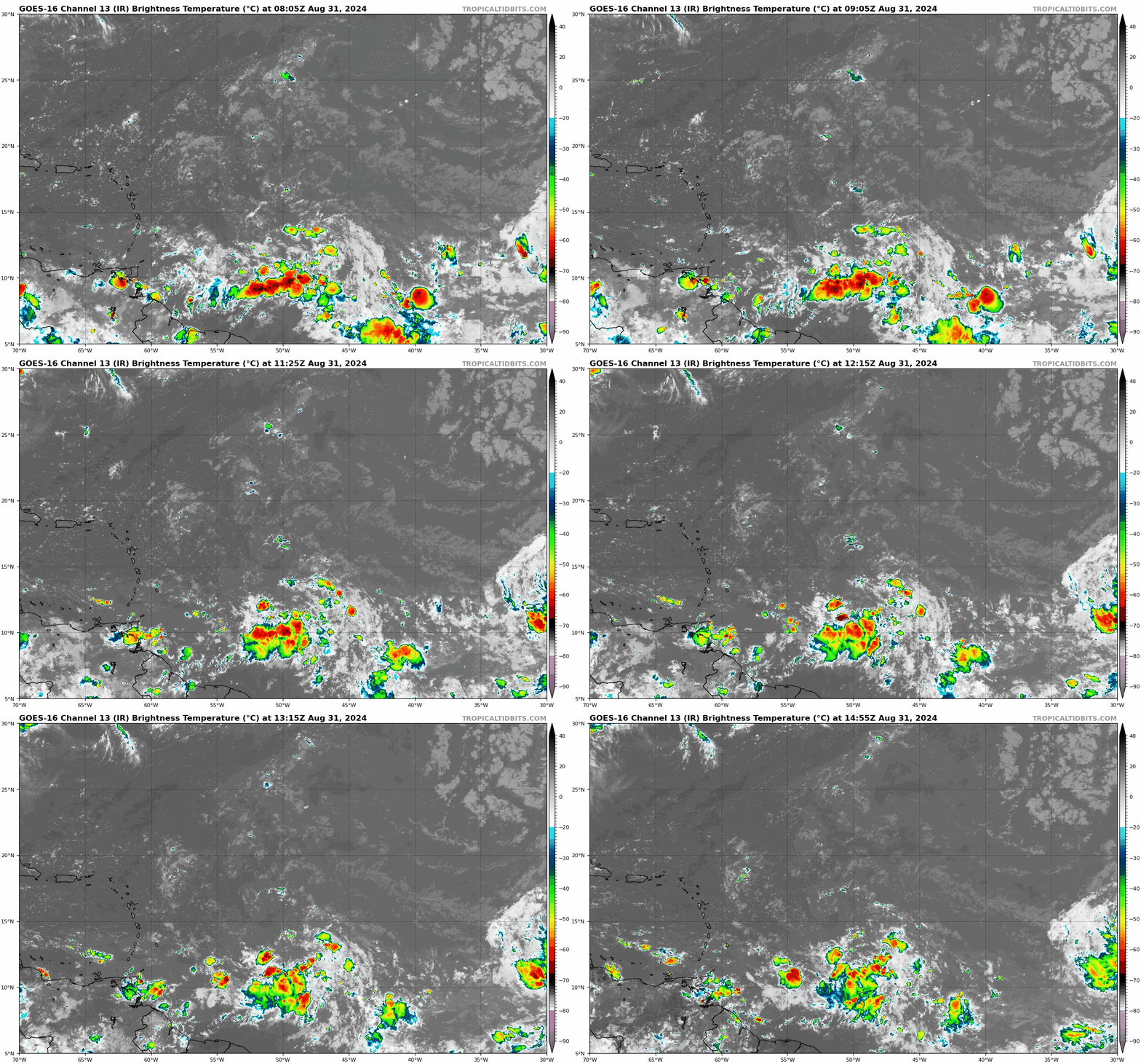
GOES imagery has been wacky this morning, but you can see the convection moving north (and seemingly east), lining up more directly with the rotation at 12-13N.

Image
2 likes   

DunedinDave
Tropical Storm
Tropical Storm
Posts: 217
Joined: Fri Aug 25, 2023 10:31 am

Re: Tropical Wave in Central Atlantic (0/50)

#552 Postby DunedinDave » Sat Aug 31, 2024 10:34 am

I noticed the 12z ICON keeps that system in the NW gulf for several days as the new system moves closer toward the central Caribbean. Any chance that could influence the direction of this system?
0 likes   

User avatar
chris_fit
Category 5
Category 5
Posts: 3222
Age: 42
Joined: Wed Sep 10, 2003 11:58 pm
Location: Tampa Bay Area, FL

Re: Tropical Wave in Central Atlantic (0/50)

#553 Postby chris_fit » Sat Aug 31, 2024 10:36 am

12z ICON faster and much weaker near / south of Jamaica through 129 hours when compared to the 00z.
0 likes   

IcyTundra
Category 5
Category 5
Posts: 1205
Joined: Mon Jun 07, 2021 9:32 pm
Location: Dickinson, Texas

Re: Tropical Wave in Central Atlantic (0/50)

#554 Postby IcyTundra » Sat Aug 31, 2024 10:51 am

12Z ICON doesn’t show development for the first time in a while in the Caribbean. Takes a tropical wave into the Yucatán.
0 likes   

User avatar
Ubuntwo
Category 5
Category 5
Posts: 1401
Age: 31
Joined: Thu Oct 05, 2017 10:41 pm

Re: Tropical Wave in Central Atlantic (0/50)

#555 Postby Ubuntwo » Sat Aug 31, 2024 10:59 am

12z GFS depicts the strung-out solution from a couple days ago.
0 likes   
Kendall -> SLO -> PBC

Memorable Storms: Katrina (for its Florida landfall...) Wilma Matthew Irma

User avatar
Spacecoast
Category 2
Category 2
Posts: 758
Joined: Thu Aug 31, 2017 2:03 pm

Re: Tropical Wave in Central Atlantic (0/50)

#556 Postby Spacecoast » Sat Aug 31, 2024 11:05 am

Roundup of Ops runs. Sept 7-9....
Basic agreement on weak, (or no) system into Yucatan.
Image
Image
Image
Image
Image
Image

Ensembles are a little different, with large spreads, but if you squint, you can estimate ensemble mean(s) are similar.
idk for sure, still early
Last edited by Spacecoast on Sat Aug 31, 2024 11:47 am, edited 1 time in total.
2 likes   

mantis83
Tropical Storm
Tropical Storm
Posts: 198
Joined: Fri Dec 05, 2003 4:47 pm

Re: Tropical Wave in Central Atlantic (0/50)

#557 Postby mantis83 » Sat Aug 31, 2024 11:31 am

models continue trending weaker and further south, good news......
1 likes   

User avatar
Category5Kaiju
Category 5
Category 5
Posts: 4052
Joined: Thu Dec 24, 2020 12:45 pm
Location: Seattle

Re: Tropical Wave in Central Atlantic (0/50)

#558 Postby Category5Kaiju » Sat Aug 31, 2024 11:38 am

Is this start of a trend, or are the models still trying to assess how this system is going to form from the monsoonal trough is the big question.
1 likes   
Unless explicitly stated, all info in my posts is based on my own opinions and observations. Tropical storms and hurricanes can be extremely dangerous. Do not think you can beat Mother Nature. Refer to an accredited weather research agency or meteorologist if you need to make serious decisions regarding an approaching storm.

Stratton23
Category 5
Category 5
Posts: 2372
Joined: Fri Jul 21, 2023 10:59 pm
Location: Katy, Tx

Re: Tropical Wave in Central Atlantic (0/50)

#559 Postby Stratton23 » Sat Aug 31, 2024 11:39 am

mantis83 youre trolling posts are getting tiring, weaker and further south initially doesn’t necessarily mean thats a good thing down the road for potential gulf coast impacts
3 likes   

TomballEd
Category 2
Category 2
Posts: 586
Age: 61
Joined: Wed Aug 16, 2023 4:52 pm
Location: Spring/Klein area, not Tomball

Re: Tropical Wave in Central Atlantic (0/50)

#560 Postby TomballEd » Sat Aug 31, 2024 11:56 am

The trend as far as keeping the system weak across most guidance is a positive sign for Gulf Coast residents. About a third of the GFS ensemble members do develop a storm before 80W, however. A weak, low latitude system is not guaranteed. Especially 6 or 7 days away.
0 likes   


Return to “Talkin' Tropics”

Who is online

Users browsing this forum: gib, weeniepatrol and 194 guests