Tropical Wave in Bay of Campeche (Is Invest 91L)

This is the general tropical discussion area. Anyone can take their shot at predicting a storms path.

Moderator: S2k Moderators

Forum rules

The posts in this forum are NOT official forecasts and should not be used as such. They are just the opinion of the poster and may or may not be backed by sound meteorological data. They are NOT endorsed by any professional institution or STORM2K. For official information, please refer to products from the National Hurricane Center and National Weather Service.

Help Support Storm2K
Message
Author
Weathertracker96
Tropical Storm
Tropical Storm
Posts: 104
Joined: Mon Oct 16, 2023 3:41 pm

Re: Tropical Wave in Central Atlantic (0/40)

#601 Postby Weathertracker96 » Sat Aug 31, 2024 2:36 pm

Teban54 wrote:
The posts in this forum are NOT official forecasts and should not be used as such. They are just the opinion of the poster and may or may not be backed by sound meteorological data. They are NOT endorsed by any professional institution or STORM2K. For official information, please refer to products from the NHC and NWS.

Let's take a break from model runs and look at how the system is evolving in real time, shall we?

Over the past few hours, especially the past hour, there seems to be substantial improvement in the wave's organization on satellite imagery. In my unprofessional opinion, near the end of the loop below, you can see the system actually becoming a coherent entity with a reasonably well-defined center, instead of a few vorts side by side with linear convection.

https://i.postimg.cc/vm07hGrd/goes16-truecolor-catl-1.gif

This trend seems to be corroborated with vorticity analysis as well. The secondary vort at 500 mb that had been in place for much of the past 24 hours seems to be either dissipating or merging with the main one (which has stacked with lower levels).

https://i.postimg.cc/bN0mbcBq/ezgif-com-animated-gif-maker-1.gif

Given the organization trends, I personally find it hard to believe the models (especially 12z runs) that make the wave strung out immediately after. But that could be just me.


Good observations. My question is if any of the models are getting this data real time? If its organizing slowly, I am just surprised the models aren't picking up on that.

Also: is the eastern side doing better than the western part?
0 likes   

User avatar
cajungal
Category 5
Category 5
Posts: 2327
Age: 48
Joined: Sun Mar 14, 2004 9:34 pm
Location: Schriever, Louisiana (60 miles southwest of New Orleans)

Re: Tropical Wave in Central Atlantic (0/40)

#602 Postby cajungal » Sat Aug 31, 2024 2:40 pm

Just because models back off for today. Doesn’t mean by tomorrow it will be back to showing similar runs from yesterday
2 likes   

User avatar
Steve
S2K Supporter
S2K Supporter
Posts: 9591
Joined: Sat Apr 05, 2003 11:41 pm
Location: Not a state-caster

Re: Tropical Wave in Central Atlantic (0/40)

#603 Postby Steve » Sat Aug 31, 2024 2:45 pm

txwxwatcher wrote:
DunedinDave wrote:
hurricane2025 wrote:If I was a betting man there won’t be a cold front like that to make a NE turn like that lol


I don’t know. This could be one of those years where fronts start diving down early. The one coming in a few days is projected to make it down pretty deep. So much so the news agencies are covering it.
https://www.cnn.com/2024/08/30/weather/ ... index.html


Exactly right. ABC13 in Houston is reporting that we may get down to the 60s next weekend with a front making its way through. That is unseasonably cool for this time of year.


It is. But look to the south or southeast of the cool high for tropical systems. When early fronts come down tropical systems often come up as part of the pattern or response to it.
2 likes   

otowntiger
Category 5
Category 5
Posts: 1921
Joined: Tue Aug 31, 2004 7:06 pm

Re: Tropical Wave in Central Atlantic (0/50)

#604 Postby otowntiger » Sat Aug 31, 2024 2:50 pm

chaser1 wrote:
MetroMike wrote:This IS season peak right now and some people on this board are expecting a trackable system and right now the basin should be ideal for development MJO or not.
This is sad to see areas of interest all strung out given the high expectations and the supposed peak right now.
Some areas of the Gulf coast need more rain and tropical systems are sometimes needed to fill basins etc. Does not always mean death and destruction from a T.S. or low end hurricane.


I slightly lean more toward MetroMike's perspective and i'll tell you why. Rightfully so, some of you point to trending ensemble forecasts, while others point toward climatology or perhaps NHC bumping up formation probability for the wave approaching the Lesser Antilles. One of the earliest lessons I learned about Meteorology was regarding "Persistence". Simply put, minus an absence of clear-cut data such as run to run model consistency and/or model corroboration, or some obvious satellite presentation showing signs of tropical genesis (or at least some increase and sustained convective consolidation) then often times the most reasonable near-term expectation is essentially more of the same. Naturally, that methodology of forecasting is crude, unspecific and has limitations. Right here and right now though, I'm looking at an Atlantic basin that is broadly suppressed and lacking well defined area's of disturbed weather other than a few whack-a-mole spots that might flare up due to diurnal forcing or divergent upper level wind shear. I was positive that a couple of named storms would develop during the first few days of September because... well.... Hyperactive season expectations, climo, anomalous SST's, yada yada yada. Well, something will eventually pop and that could be in 48 hr's or a week from now but for the moment I really do tend to consider Persistence as the best near-term guidance. Show me the money! :lol:

Agreed and well said.
0 likes   

TomballEd
Category 2
Category 2
Posts: 585
Age: 61
Joined: Wed Aug 16, 2023 4:52 pm
Location: Spring/Klein area, not Tomball

Re: Tropical Wave in Central Atlantic (0/40)

#605 Postby TomballEd » Sat Aug 31, 2024 2:59 pm

Just one model cycle, but the theme of 12Z models in general is later development and further W. I wouldn't have dropped from 50% to 40% based on a single model cycle. If the trend remains, than I can see lowering odds. Just me.
4 likes   

colbroe
Tropical Storm
Tropical Storm
Posts: 194
Joined: Sat Aug 07, 2004 4:57 am

Re: Tropical Wave in Central Atlantic (0/40)

#606 Postby colbroe » Sat Aug 31, 2024 3:11 pm

There is now a 1012 low attached to this area of intrest , and it also looks like it is consolidating just before the island chain
0 likes   

otowntiger
Category 5
Category 5
Posts: 1921
Joined: Tue Aug 31, 2004 7:06 pm

Re: Tropical Wave in Central Atlantic (0/40)

#607 Postby otowntiger » Sat Aug 31, 2024 3:51 pm

Ubuntwo wrote:
Stratton23 wrote:The EPS still has numerous members showing a powerful system affecting the gulf coast, we got a long ways to go with this one folks, Mexico- florida is in play for something, or also just a weak system

Yes, although we are down to ~37% developing by hour 144 vs. 50% on the 6z and 59% on the 0z.

Can’t deny that trend! It’s definitely in keeping with this suppressed period we are most definitely in. 8-) :sun:
0 likes   

otowntiger
Category 5
Category 5
Posts: 1921
Joined: Tue Aug 31, 2004 7:06 pm

Re: Tropical Wave in Central Atlantic (0/40)

#608 Postby otowntiger » Sat Aug 31, 2024 3:58 pm

TomballEd wrote:Just one model cycle, but the theme of 12Z models in general is later development and further W. I wouldn't have dropped from 50% to 40% based on a single model cycle. If the trend remains, than I can see lowering odds. Just me.
I would hazard a guess that they are not basing their reduction in chances solely on one set of model runs. They have a lot more resources and personal experience and skill than most of us here.

And by the way if this weren’t a suppressed cycle or lull we’d be talking about multiple systems throughout the basin, instead we got one weak cluster of clouds that has diminishing odds and less and less bullish model depictions. We are less than a week and a half from the peak and the switch flip is now 11 days late and counting.
Last edited by otowntiger on Sat Aug 31, 2024 4:01 pm, edited 1 time in total.
0 likes   

User avatar
cycloneye
Admin
Admin
Posts: 143877
Age: 68
Joined: Thu Oct 10, 2002 10:54 am
Location: San Juan, Puerto Rico

Re: Tropical Wave east of Lesser Antilles (0/40)

#609 Postby cycloneye » Sat Aug 31, 2024 3:59 pm

MarioProtVI, edited the title to add "east of Lesser Antilles".
1 likes   
Visit the Caribbean-Central America Weather Thread where you can find at first post web cams,radars
and observations from Caribbean basin members Click Here

Frank P
S2K Supporter
S2K Supporter
Posts: 2772
Joined: Fri Aug 29, 2003 10:52 am
Location: Biloxi Beach, Ms
Contact:

Re: Tropical Wave east of Lesser Antilles (0/40)

#610 Postby Frank P » Sat Aug 31, 2024 4:22 pm

Well, it's not going to win a beauty contest but late afternoon's vis sat image appears to be more improved with more deep convection than earlier today.
Image
Image
4 likes   

User avatar
Ubuntwo
Category 5
Category 5
Posts: 1401
Age: 31
Joined: Thu Oct 05, 2017 10:41 pm

Re: Tropical Wave east of Lesser Antilles (0/40)

#611 Postby Ubuntwo » Sat Aug 31, 2024 4:25 pm

Image
6 likes   
Kendall -> SLO -> PBC

Memorable Storms: Katrina (for its Florida landfall...) Wilma Matthew Irma

Stratton23
Category 5
Category 5
Posts: 2371
Joined: Fri Jul 21, 2023 10:59 pm
Location: Katy, Tx

Re: Tropical Wave east of Lesser Antilles (0/40)

#612 Postby Stratton23 » Sat Aug 31, 2024 4:26 pm

18z ICON has a more concentrated area of vortcity in the western caribbean at the end of this run, it was an open wave on the last run, starting to develop again
2 likes   

Frank P
S2K Supporter
S2K Supporter
Posts: 2772
Joined: Fri Aug 29, 2003 10:52 am
Location: Biloxi Beach, Ms
Contact:

Re: Tropical Wave east of Lesser Antilles (0/40)

#613 Postby Frank P » Sat Aug 31, 2024 4:26 pm


yeah, you can really see the convection building on the vis sat loops... nice images
1 likes   

User avatar
Nimbus
Category 5
Category 5
Posts: 5274
Joined: Mon Jul 19, 2004 10:54 am

Re: Tropical Wave east of Lesser Antilles (0/40)

#614 Postby Nimbus » Sat Aug 31, 2024 4:37 pm

Frank P wrote:

yeah, you can really see the convection building on the vis sat loops... nice images


Its tracking over warmer SST's and convection near the wave apex looks like it wants to close off.
Once the models are initialized with a closed they will likely be more bullish on development.
1 likes   

User avatar
wzrgirl1
S2K Supporter
S2K Supporter
Posts: 1323
Joined: Sat Sep 04, 2004 6:44 am
Location: Pembroke Pines, Florida

Re: Tropical Wave east of Lesser Antilles (0/40)

#615 Postby wzrgirl1 » Sat Aug 31, 2024 4:37 pm

Can someone tell me the difference between ensembles and operational models in a sentence or two please. I have been on S2k for 20 years and there is still so much to learn IMO.
0 likes   

User avatar
Nimbus
Category 5
Category 5
Posts: 5274
Joined: Mon Jul 19, 2004 10:54 am

Re: Tropical Wave east of Lesser Antilles (0/40)

#616 Postby Nimbus » Sat Aug 31, 2024 4:45 pm

18Z GFS closes off a 1011 mb low near 13.5n -51w which is a little north of the current apex near 12n -49w.
Should be a good run.
1 likes   

User avatar
Teban54
Category 5
Category 5
Posts: 3168
Joined: Sat May 19, 2018 1:19 pm

Re: Tropical Wave east of Lesser Antilles (0/40)

#617 Postby Teban54 » Sat Aug 31, 2024 4:48 pm

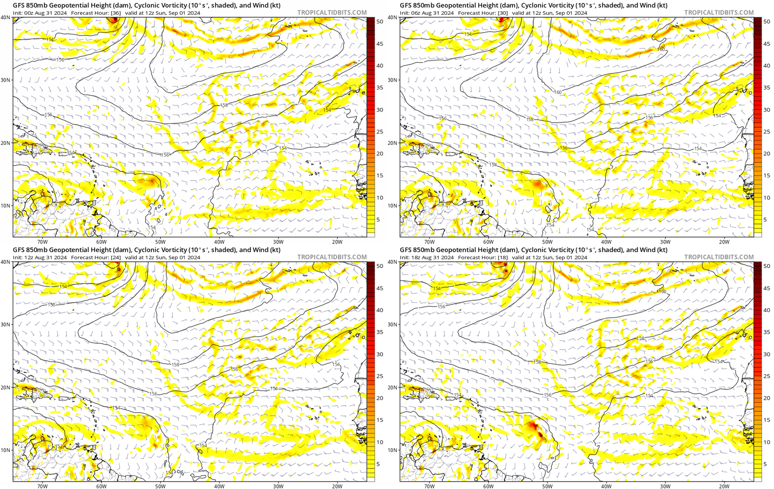
Nimbus wrote:18Z GFS closes off a 1011 mb low near 13.5n -51w which is a little north of the current apex near 12n -49w.
Should be a good run.

Significantly stronger vorticity at 18 hours compared to past runs. This trend also extends to 30 hrs as well, but not captured in the GIF.

Image
1 likes   

User avatar
Ubuntwo
Category 5
Category 5
Posts: 1401
Age: 31
Joined: Thu Oct 05, 2017 10:41 pm

Re: Tropical Wave east of Lesser Antilles (0/40)

#618 Postby Ubuntwo » Sat Aug 31, 2024 4:48 pm

Nimbus wrote:18Z GFS closes off a 1011 mb low near 13.5n -51w which is a little north of the current apex near 12n -49w.
Should be a good run.

Looks like this run picked up on the convective developments, and perhaps had this earlier ASCAT pass ingested (surprised it was not posted here!):
Image
3 likes   
Kendall -> SLO -> PBC

Memorable Storms: Katrina (for its Florida landfall...) Wilma Matthew Irma

IcyTundra
Category 5
Category 5
Posts: 1205
Joined: Mon Jun 07, 2021 9:32 pm
Location: Dickinson, Texas

Re: Tropical Wave east of Lesser Antilles (0/40)

#619 Postby IcyTundra » Sat Aug 31, 2024 4:56 pm

Hard to trust the GFS with how inconsistent it has been.
1 likes   

User avatar
Steve
S2K Supporter
S2K Supporter
Posts: 9591
Joined: Sat Apr 05, 2003 11:41 pm
Location: Not a state-caster

Re: Tropical Wave east of Lesser Antilles (0/40)

#620 Postby Steve » Sat Aug 31, 2024 5:00 pm

wzrgirl1 wrote:Can someone tell me the difference between ensembles and operational models in a sentence or two please. I have been on S2k for 20 years and there is still so much to learn IMO.


Super basic is that Ensembles are x number of runs with slightly different tweaks to account for atmospheric differences.

https://www.weather.gov/about/models
1 likes   


Return to “Talkin' Tropics”

Who is online

Users browsing this forum: No registered users and 142 guests