Tropical Wave in Bay of Campeche (Is Invest 91L)
Moderator: S2k Moderators
Forum rules

The posts in this forum are NOT official forecasts and should not be used as such. They are just the opinion of the poster and may or may not be backed by sound meteorological data. They are NOT endorsed by any professional institution or STORM2K. For official information, please refer to products from the National Hurricane Center and National Weather Service.
-
Stratton23
- Category 5

- Posts: 3575
- Joined: Fri Jul 21, 2023 10:59 pm
- Location: Katy, Tx
Re: Tropical Wave east of Lesser Antilles (10/40)
The ICON does close off a system, but land interaction with the yucatan hurts it, but bizarrely it looks like it wants the system near the NW gulf to actually kind of steal this waves energy , kind looks like the energy merges with the gulf low
0 likes
-
Keldeo1997
- Category 2

- Posts: 688
- Joined: Fri Oct 11, 2019 11:35 pm
Re: Tropical Wave east of Lesser Antilles (10/40)
Idk if we should take this ICON run seriously. It has the Gulf AOI stalled in the Gulf for almost 2 weeks.
Last edited by Keldeo1997 on Sun Sep 01, 2024 12:04 am, edited 1 time in total.
2 likes
-
MarioProtVI
- Category 5
- Posts: 1039
- Age: 24
- Joined: Sun Sep 29, 2019 7:33 pm
- Location: New Jersey
Re: Tropical Wave east of Lesser Antilles (10/40)
Looks like my suspicions were confirmed with the 00z GFS - 18z was far too excited/possibly spurious. Looks on track to be similar to 06z or more likely 12z which didn’t develop it/only produced a very weak storm. The downtrend continues..
Edit: Maybe not since it looks a little stronger then 12z but we’ll see.
Edit 2: That aged badly.
Edit: Maybe not since it looks a little stronger then 12z but we’ll see.
Edit 2: That aged badly.
Last edited by MarioProtVI on Sat Aug 31, 2024 11:45 pm, edited 1 time in total.
1 likes
Re: Tropical Wave east of Lesser Antilles (10/40)
At first glance, the 00z gfs joins Icon with no real development of this system and it stays south and moves into Honduras/Nicaragua. Energy not as weak as 12z, but still not enough to develop anything, vastly different from 18z, but....
One interesting new element is a different area splits toward the north at 90 hours, while the main section keeps west, this second area could do something later, but the southern area didn't exist at all in the 18z. The back and forth is the models just struggling on what to latch onto I think.
By 135 hours the north area starts to develop.

Shoots the Gap between Cuba and the Yucatan Peninsula

Gets into the middle of the Gulf

One interesting new element is a different area splits toward the north at 90 hours, while the main section keeps west, this second area could do something later, but the southern area didn't exist at all in the 18z. The back and forth is the models just struggling on what to latch onto I think.
By 135 hours the north area starts to develop.
Shoots the Gap between Cuba and the Yucatan Peninsula
Gets into the middle of the Gulf
Last edited by BobHarlem on Sat Aug 31, 2024 11:38 pm, edited 4 times in total.
0 likes
-
Iceresistance

- Category 5
- Posts: 9607
- Age: 22
- Joined: Sat Oct 10, 2020 9:45 am
- Location: Tecumseh, OK/Norman, OK
Re: Tropical Wave east of Lesser Antilles (10/40)
MarioProtVI wrote:Looks like my suspicions were confirmed with the 00z GFS - 18z was far too excited/possibly spurious. Looks on track to be similar to 06z or more likely 12z which didn’t develop it/only produced a very weak storm.The downtrend continues..
Edit: Maybe not since it looks a little stronger then 12z but we’ll see.
I am wondering if we are getting into the mid-range shenanigans
1 likes
Bill 2015 & Beta 2020
Winter 2020-2021
All observations are in Tecumseh, OK unless otherwise noted.
Winter posts are focused mainly for Oklahoma & Texas.
Take any of my forecasts with a grain of salt, refer to the NWS, SPC, and NHC for official information
Never say Never with weather! Because ANYTHING is possible!
Winter 2020-2021
All observations are in Tecumseh, OK unless otherwise noted.
Winter posts are focused mainly for Oklahoma & Texas.
Take any of my forecasts with a grain of salt, refer to the NWS, SPC, and NHC for official information
Never say Never with weather! Because ANYTHING is possible!

Re: Tropical Wave east of Lesser Antilles (10/40)
cmc plows through the yucatan, headed for the pacific fwiw.....
0 likes

Re: Tropical Wave east of Lesser Antilles (10/40)
BobHarlem wrote:At first glance, the 00z gfs joins Icon with no real development of this system and it stays south and moves into Honduras/Nicaragua. Energy not as weak as 12z, but still not enough to develop anything, vastly different from 18z, but one interesting new element is a different area splits toward the north at 90 hours, while the main section keeps west, this second area could do something later, but the southern area didn't exist at all in the 18z. The back and forth is the models just struggling on what to latch onto I think.
By 135 hours the north area starts to develop.
I have been watching this too much for someone who doesn't know any better, but here's my interpretation of it:
- The wave fails to close off a circulation before entering the Caribbean, which is not surprising.
- Due to what's likely to be strong trades in Eastern Caribbean (and possibly some shear), even though the system still tries to organize during the first 12 hours in the Caribbean, it starts becoming decoupled very soon. Low-level vorticity starts outrunning mid-level rotation.
- Around 96-120 hrs, there's now a 5-degree gap between the low-level and mid-level vorts. The low-level center, which is further SW, tries to develop a LLC that reaches just offshore Nicaragua. But the MLC is over Jamaica, and it attempts -- and succeeds -- to work its way down to form a new LLC just west of there, which then absorbs the old LLC. Basically a center relocation.
- The system now finally becomes vertically stacked between Jamaica and Yucatan, and intensifies (down to 998 mb at 168 hrs as of writing).
I could be wrong with this, so it would be good for someone else to confirm.
Edit: I quickly compared it to other models. CMC (0z at least) doesn't show the vortex tilt at all, and shows the low- and mid-level vorts lining up throughout the Caribbean. As for ECMWF, except the 12z 8/30 run (which shows a TD at Lesser Antilles), other runs do show some tilt, but much less than GFS. Steering probably plays a bigger role once the system gets to Western Caribbean.
Last edited by Teban54 on Sat Aug 31, 2024 11:38 pm, edited 1 time in total.
0 likes
TC naming lists: retirements and intensity
Most aggressive Advisory #1's in North Atlantic (cr. kevin for starting the list)
Most aggressive Advisory #1's in North Atlantic (cr. kevin for starting the list)


Re: Tropical Wave east of Lesser Antilles (10/40)
Stratton23 wrote:Mantis83 uh yeah no, this is definitely a troll comment, the ICON absolutely has something, a closed low developing in the western caribbean
Let's be careful about troll labeling. The 0Z ICON flat out does not develop this disturbance into a TD but merely depicts a 1008mb low within a broad 1010 pressure field. Regardless, I would equally suggest others NOT label your contrary perspective as outright -removed-. Let's just keep it real.
2 likes
Andy D
(For official information, please refer to the NHC and NWS products.)
(For official information, please refer to the NHC and NWS products.)
-
Stratton23
- Category 5
- Posts: 3575
- Joined: Fri Jul 21, 2023 10:59 pm
- Location: Katy, Tx
Re: Tropical Wave east of Lesser Antilles (10/40)
GFS came in a decent shift west from its 18z run
0 likes
-
Category5Kaiju

- Category 5
- Posts: 4346
- Joined: Thu Dec 24, 2020 12:45 pm
- Location: Seattle during the summer, Phoenix during the winter
Re: Tropical Wave east of Lesser Antilles (10/40)
GFS now has Katrina 2.0, doesn’t look very pretty for New Orleans
1 likes
Unless explicitly stated, all information in my posts is based on my own opinions and observations. Tropical storms and hurricanes can be extremely dangerous. Refer to an accredited weather research agency or meteorologist if you need to make serious decisions regarding an approaching storm.
-
hurricane2025
- Category 1

- Posts: 254
- Joined: Thu Apr 08, 2021 10:36 am
Re: Tropical Wave east of Lesser Antilles (10/40)
La to Mexico, until we have a center and it’s 4-5 days from landfall then start worrying 11 days out long time
1 likes
Re: Tropical Wave east of Lesser Antilles (10/40)
0z GFS clips Port Eads/Extreme Southeast LA, then landfalls around Biloxi or Pascagoula, MS. Mobile, AL would get massive surge from this approach.


Last edited by BobHarlem on Sat Aug 31, 2024 11:48 pm, edited 1 time in total.
0 likes

Re: Tropical Wave east of Lesser Antilles (10/40)
Keldeo1997 wrote:Idk if we should this ICON run seriously. It has the Gulf AOI stalled in the Gulf for almost 2 weeks.
It had the current feature from last Saturday but who knows? GFS has a bad high end cat 3 around 27/90. CMC crosses over. Icon’s current NW Gulf low ingests this wave. They’re all probably wrong because it’s over a week out.
3 likes
Re: Tropical Wave east of Lesser Antilles (10/40)
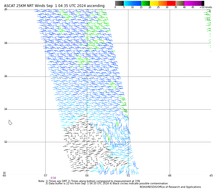
ASCAT pass from 4 hours ago: (Edit: Looks like it missed where the center was at that time)
Last edited by Teban54 on Sat Aug 31, 2024 11:51 pm, edited 1 time in total.
0 likes
TC naming lists: retirements and intensity
Most aggressive Advisory #1's in North Atlantic (cr. kevin for starting the list)
Most aggressive Advisory #1's in North Atlantic (cr. kevin for starting the list)
Re: Tropical Wave east of Lesser Antilles (10/40)
Teban54 wrote:BobHarlem wrote:At first glance, the 00z gfs joins Icon with no real development of this system and it stays south and moves into Honduras/Nicaragua. Energy not as weak as 12z, but still not enough to develop anything, vastly different from 18z, but one interesting new element is a different area splits toward the north at 90 hours, while the main section keeps west, this second area could do something later, but the southern area didn't exist at all in the 18z. The back and forth is the models just struggling on what to latch onto I think.
By 135 hours the north area starts to develop.
I have been watching this too much for someone who doesn't know any better, but here's my interpretation of it:This evolution seems pretty similar to other runs in the past 3 days that developed the system in Western Caribbean, but all these runs have varying degrees of tilt, with this run probably being the most extreme. On the other hand, thanks to increased organization prior to entering the Caribbean (one of the strongest in the short term if we exclude those runs that form a TC in Eastern Caribbean), the wave holds itself together enough to actually sort out these issues in Western Caribbean.
- The wave fails to close off a circulation before entering the Caribbean, which is not surprising.
- Due to what's likely to be strong trades in Eastern Caribbean (and possibly some shear), even though the system still tries to organize during the first 12 hours in the Caribbean, it starts becoming decoupled very soon. Low-level vorticity starts outrunning mid-level rotation.
- Around 96-120 hrs, there's now a 5-degree gap between the low-level and mid-level vorts. The low-level center, which is further SW, tries to develop a LLC that reaches just offshore Nicaragua. But the MLC is over Jamaica, and it attempts -- and succeeds -- to work its way down to form a new LLC just west of there, which then absorbs the old LLC. Basically a center relocation.
- The system now finally becomes vertically stacked between Jamaica and Yucatan, and intensifies (down to 998 mb at 168 hrs as of writing).
I could be wrong with this, so it would be good for someone else to confirm.
Your thought experiment seems entirely plausible. Just to be fair, I wouldn't rule out the earlier GFS 18z model run either. I'm not referring to the extent of deepening but simply the implication depicting Caribbean development and some level of establishing run to run consistency.
1 likes
Andy D
(For official information, please refer to the NHC and NWS products.)
(For official information, please refer to the NHC and NWS products.)
Re: Tropical Wave east of Lesser Antilles (10/40)
chaser1 wrote:Teban54 wrote:BobHarlem wrote:At first glance, the 00z gfs joins Icon with no real development of this system and it stays south and moves into Honduras/Nicaragua. Energy not as weak as 12z, but still not enough to develop anything, vastly different from 18z, but one interesting new element is a different area splits toward the north at 90 hours, while the main section keeps west, this second area could do something later, but the southern area didn't exist at all in the 18z. The back and forth is the models just struggling on what to latch onto I think.
By 135 hours the north area starts to develop.
I have been watching this too much for someone who doesn't know any better, but here's my interpretation of it:This evolution seems pretty similar to other runs in the past 3 days that developed the system in Western Caribbean, but all these runs have varying degrees of tilt, with this run probably being the most extreme. On the other hand, thanks to increased organization prior to entering the Caribbean (one of the strongest in the short term if we exclude those runs that form a TC in Eastern Caribbean), the wave holds itself together enough to actually sort out these issues in Western Caribbean.
- The wave fails to close off a circulation before entering the Caribbean, which is not surprising.
- Due to what's likely to be strong trades in Eastern Caribbean (and possibly some shear), even though the system still tries to organize during the first 12 hours in the Caribbean, it starts becoming decoupled very soon. Low-level vorticity starts outrunning mid-level rotation.
- Around 96-120 hrs, there's now a 5-degree gap between the low-level and mid-level vorts. The low-level center, which is further SW, tries to develop a LLC that reaches just offshore Nicaragua. But the MLC is over Jamaica, and it attempts -- and succeeds -- to work its way down to form a new LLC just west of there, which then absorbs the old LLC. Basically a center relocation.
- The system now finally becomes vertically stacked between Jamaica and Yucatan, and intensifies (down to 998 mb at 168 hrs as of writing).
I could be wrong with this, so it would be good for someone else to confirm.
Your thought experiment seems entirely plausible. Just to be fair, I wouldn't rule out the earlier GFS 18z model run either. I'm not referring to the extent of deepening but simply the implication depicting Caribbean development and some level of establishing run to run consistency.
To be clear, I was describing my understanding of the 0z GFS run, not suggesting a hypothetical "thought experiment" that I imagine the system can develop.
0 likes
TC naming lists: retirements and intensity
Most aggressive Advisory #1's in North Atlantic (cr. kevin for starting the list)
Most aggressive Advisory #1's in North Atlantic (cr. kevin for starting the list)
Re: Tropical Wave east of Lesser Antilles (10/40)
2 runs in a row gfs slams the central gulf coast, let's see what the euro says about it
2 likes
-
TomballEd
- Category 5
- Posts: 1322
- Age: 62
- Joined: Wed Aug 16, 2023 4:52 pm
- Location: Spring/Klein area, not Tomball
Re: Tropical Wave east of Lesser Antilles (10/40)
~10 days out, and models changing between runs, solutions from a wave into Central America, a major hurricane in the N. Gulf, or Florida, are all possible.
Note also the strength of the 500 mb trough or closed low changes run to run on the GFS. If the system does develop, the 500 mb pattern over the US will be very important, and the GFS isn't stable on that,

Note also the strength of the 500 mb trough or closed low changes run to run on the GFS. If the system does develop, the 500 mb pattern over the US will be very important, and the GFS isn't stable on that,
0 likes

Re: Tropical Wave east of Lesser Antilles (10/40)
ICON drops it as soon as GFS consistently starts developing it. Unreal how inconsistent models have been. Similar things happened during Beryl as well. It's like they're on a seesaw and the second one develops another stops.
0 likes
-
ConvergenceZone
.gif)
- Category 5
- Posts: 5241
- Joined: Fri Jul 29, 2005 1:40 am
- Location: Northern California
Re: Tropical Wave east of Lesser Antilles (10/40)
Well I guess GFS put to rest those saying that it would be back to being weak with tonight's model run
GFS wasn't happy about that, so it set out to prove them wrong
GFS wasn't happy about that, so it set out to prove them wrong
2 likes
Who is online
Users browsing this forum: No registered users and 144 guests