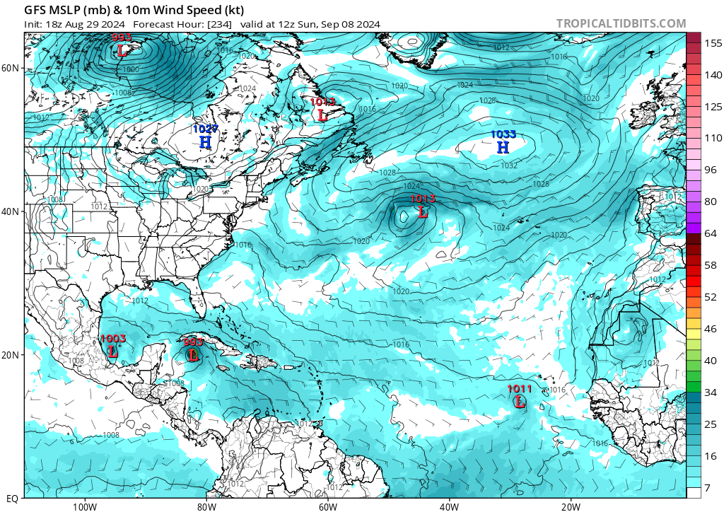
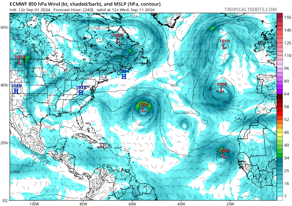
2024 Global Model Runs Discussion (Out thru day 16)

This is the general tropical discussion area. Anyone can take their shot at predicting a storms path.

Moderator: S2k Moderators

Forum rules

The posts in this forum are NOT official forecasts and should not be used as such. They are just the opinion of the poster and may or may not be backed by sound meteorological data. They are NOT endorsed by any professional institution or STORM2K. For official information, please refer to products from the National Hurricane Center and National Weather Service.

Help Support Storm2K
Message
Author
User avatar
NDG
S2K Supporter
S2K Supporter
Posts: 15446
Joined: Sun Jul 09, 2006 10:14 pm
Location: Orlando, FL

Re: 2024 Global Model Runs Discussion (Out thru day 16)

#1641 Postby NDG » Thu Aug 29, 2024 11:50 am

skyline385 wrote:
NDG wrote:Both the GFS and Euro have backed away some from development in the central Atlantic and eastern Caribbean, even their ensembles have less support than previous runs.
The 20% highlight the NHC is being generous unless global models start trending again towards development within the next 7 days. Crazy that we are 2 weeks from the peak of the season and there's really no strong persistent signal that the Atlantic will wake up before then. I hope this doesn't mean that we will have a relatively busy October and early November like some previous seasons because conditions for the most part are favorable and forecasted to stay favorable.


20% is fine looking at ensemble support, the NHC AOI represents only a chance at TC formation and there are more than enough members in 7-day range to warrant it

https://i.imgur.com/ePNTF5r.png

https://i.imgur.com/IBxCXZ4.png


That was less than 10% of the EC ensembles showing development :wink:
0 likes   

User avatar
mitchell
Category 1
Category 1
Posts: 408
Joined: Wed Mar 19, 2003 8:22 am
Location: Delaware
Contact:

Re: 2024 Global Model Runs Discussion (Out thru day 16)

#1642 Postby mitchell » Thu Aug 29, 2024 11:52 am

Stratton23 wrote:Cycloneye i think its still down, because a lot of the data/ models are still stuck on 00z runs from last night, some are just starting now i think


GFS...06z and 12z runs now completed and up. Pretty big difference too! O6 z has a 964 hurricane in the GOM on September 9, 12z no storm in that region.

Image
2 likes   

jlauderdal
S2K Supporter
S2K Supporter
Posts: 7182
Joined: Wed May 19, 2004 5:46 am
Location: NE Fort Lauderdale
Contact:

Re: RE: Re: 2024 Global Model Runs Discussion (Out thru day 16)

#1643 Postby jlauderdal » Thu Aug 29, 2024 12:21 pm

mitchell wrote:
Stratton23 wrote:Cycloneye i think its still down, because a lot of the data/ models are still stuck on 00z runs from last night, some are just starting now i think


GFS...06z and 12z runs now completed and up. Pretty big difference too! O6 z has a 964 hurricane in the GOM on September 9, 12z no storm in that region.

https://i0.wp.com/www.mostoke.com/wp-co ... =730&ssl=1
This is a good example of why the focus is on the ensembles at this range.
3 likes   

otowntiger
Category 5
Category 5
Posts: 1921
Joined: Tue Aug 31, 2004 7:06 pm

Re: 2024 Global Model Runs Discussion (Out thru day 16)

#1644 Postby otowntiger » Thu Aug 29, 2024 12:22 pm

mitchell wrote:
Stratton23 wrote:Cycloneye i think its still down, because a lot of the data/ models are still stuck on 00z runs from last night, some are just starting now i think


GFS...06z and 12z runs now completed and up. Pretty big difference too! O6 z has a 964 hurricane in the GOM on September 9, 12z no storm in that region.
https://i0.wp.com/www.mostoke.com/wp-content/uploads/hm_bbpui/135429/wos2hcpmllc12sv5tv8cs812tvjgx9r2.gif?w=730&ssl=1


LOL!! Im not the least bit surprised. In fact during this mornings hoopla of the runs some were noting what a difference 12 hours made I almost mentioned that it may very well not be there the very next run- and here we are! What a difference 6 hours make! 8-) :sun: :D
2 likes   

BIFF_THE_UNRULY
Tropical Storm
Tropical Storm
Posts: 143
Joined: Fri Jun 28, 2024 2:12 pm

Re: 2024 Global Model Runs Discussion (Out thru day 16)

#1645 Postby BIFF_THE_UNRULY » Thu Aug 29, 2024 12:55 pm

mitchell wrote:
Stratton23 wrote:Cycloneye i think its still down, because a lot of the data/ models are still stuck on 00z runs from last night, some are just starting now i think


GFS...06z and 12z runs now completed and up. Pretty big difference too! O6 z has a 964 hurricane in the GOM on September 9, 12z no storm in that region.

https://i0.wp.com/www.mostoke.com/wp-content/uploads/hm_bbpui/135429/wos2hcpmllc12sv5tv8cs812tvjgx9r2.gif?w=730&ssl=1


no consensus for any storm at this point. gonna have to wait it out. We will have confirmation likely by Labor day
2 likes   

User avatar
Teban54
Category 5
Category 5
Posts: 3204
Joined: Sat May 19, 2018 1:19 pm

Re: 2024 Global Model Runs Discussion (Out thru day 16)

#1646 Postby Teban54 » Thu Aug 29, 2024 5:49 pm

What a difference 6 hours make! :lol:

Image

(To be clear, the BoC and eastern Atlantic systems on this run look like classic GFS biases that are unlikely to materialize.)
1 likes   

User avatar
REDHurricane
Category 1
Category 1
Posts: 396
Age: 27
Joined: Sun Jul 03, 2022 2:36 pm
Location: Northeast Pacific Ocean

Re: 2024 Global Model Runs Discussion (Out thru day 16)

#1647 Postby REDHurricane » Thu Aug 29, 2024 9:47 pm

REDHurricane wrote:Before this September 5 deadline, I personally don't see the point in poring over every successive model run as if there's some great insight to be gained from any of them... Typically this is the time of year where I'm eagerly awaiting every new model forecast along with everyone else, but since the models are still all over the place with no consistency on a run-to-run basis I am choosing to wait until Thursday/Friday to really start paying attention to them again.


Ha looks like I made a good decision on Monday morning when I wrote this, just goes to show that a few extra days of data can make all the difference for our beloved computer models :shave:
1 likes   

User avatar
Hammy
Category 5
Category 5
Posts: 5849
Age: 41
Joined: Fri May 25, 2012 5:25 pm
Contact:

Re: 2024 Global Model Runs Discussion (Out thru day 16)

#1648 Postby Hammy » Thu Aug 29, 2024 11:07 pm

And just like that, the GFS/GEM are back to "hurricane season? what hurricane season?" with barely any vorticity going through the Caribbean :roll:
0 likes   
The above post is not official and should not be used as such. It is the opinion of the poster and may or may not be backed by sound meteorological data. It is not endorsed by any professional institution or storm2k.org. For official information, please refer to the NHC and NWS products.

User avatar
Steve
S2K Supporter
S2K Supporter
Posts: 9617
Joined: Sat Apr 05, 2003 11:41 pm
Location: Not a state-caster

Re: 2024 Global Model Runs Discussion (Out thru day 16)

#1649 Postby Steve » Fri Aug 30, 2024 8:15 am

Hammy wrote:And just like that, the GFS/GEM are back to "hurricane season? what hurricane season?" with barely any vorticity going through the Caribbean :roll:


Operational 06z has a 949mb (solid Cat 3) bearing down on Lake Charles at 12z Wednesday, 9/11/24 which is 12 days out. EC had a similar output yesterday at 13.5 days. Too far out to put any stock in anything actually being there around that time, but it's something to note for now. ICON 06z is back to closing off the low in the NW Gulf and sits it over the Texas Coast.

GFS 294 hours
https://www.tropicaltidbits.com/analysi ... 006&fh=294

ICON this upcoming Wednesday
https://www.tropicaltidbits.com/analysi ... 006&fh=120
3 likes   

User avatar
Jr0d
S2K Supporter
S2K Supporter
Posts: 1409
Joined: Tue Aug 27, 2019 10:52 am
Location: Cayo Hueso

Re: 2024 Global Model Runs Discussion (Out thru day 16)

#1650 Postby Jr0d » Fri Aug 30, 2024 11:45 pm

jlauderdal wrote:
Jr0d wrote:I am willing to bet that by Labor Day weekend(August 31st) that somewhere in the CONUS will be either in an orange potential development cone or in the cone of uncertainty from a classified system.

If I am wrong I will give Storm2k $10...if anyone takes me up on the bet and I am right, they will donate $10...

Any takers?

How are we looking?


We have a lemon NOT an orange so I will making a donation.
1 likes   

jlauderdal
S2K Supporter
S2K Supporter
Posts: 7182
Joined: Wed May 19, 2004 5:46 am
Location: NE Fort Lauderdale
Contact:

Re: RE: Re: 2024 Global Model Runs Discussion (Out thru day 16)

#1651 Postby jlauderdal » Sat Aug 31, 2024 5:26 am

Jr0d wrote:
jlauderdal wrote:
Jr0d wrote:I am willing to bet that by Labor Day weekend(August 31st) that somewhere in the CONUS will be either in an orange potential development cone or in the cone of uncertainty from a classified system.

If I am wrong I will give Storm2k $10...if anyone takes me up on the bet and I am right, they will donate $10...

Any takers?

How are we looking?


We have a lemon NOT an orange so I will making a donation.
I will be making my 2nd donation this season, will match your 10 and a little extra as a Labor Day bonus. Reach out anytime you want try again.
1 likes   

User avatar
Jr0d
S2K Supporter
S2K Supporter
Posts: 1409
Joined: Tue Aug 27, 2019 10:52 am
Location: Cayo Hueso

Re: RE: Re: 2024 Global Model Runs Discussion (Out thru day 16)

#1652 Postby Jr0d » Sat Aug 31, 2024 11:46 am

jlauderdal wrote:I will be making my 2nd donation this season, will match your 10 and a little extra as a Labor Day bonus. Reach out anytime you want try again.


Donated. Didn't do it last night because I may have had a few to many drinks.

I accidentally donated twice when I proposed the bet(didn't realize the 1st one we thru because I wasn't logged in to PayPal and didn't get a transaction number)

I do like how this played out...with a lemon popping up in the final hours making it literally going to the final hour with the Gulf of area of interest. I also thought we me get a lemon for the area in the Bahamas as well but not even the mesoscale models are hinting at development.
1 likes   

User avatar
wxman57
Moderator-Pro Met
Moderator-Pro Met
Posts: 22975
Age: 67
Joined: Sat Jun 21, 2003 8:06 pm
Location: Houston, TX (southwest)

Re: 2024 Global Model Runs Discussion (Out thru day 16)

#1653 Postby wxman57 » Sat Aug 31, 2024 4:12 pm

I'm liking the 12z model runs since they backed off on Caribbean/Gulf development. Even though I've said that the safest place to be is where the GFS puts a strong hurricane at 384 hrs, I still didn't like it pointed at me! We'll probably get a storm in the subtropical Atlantic over the next 10 days. Wouldn't rule out a quick spin-up in the Gulf, as the ICON has been strongly in favor of. Meanwhile, we just got back from a 20 mile bike ride. Left home at 1:30pm with the temperature of only 84 degrees. It's only 89 at 4pm. Quite cool for late August.
4 likes   

otowntiger
Category 5
Category 5
Posts: 1921
Joined: Tue Aug 31, 2004 7:06 pm

Re: 2024 Global Model Runs Discussion (Out thru day 16)

#1654 Postby otowntiger » Sat Aug 31, 2024 4:45 pm

wxman57 wrote:I'm liking the 12z model runs since they backed off on Caribbean/Gulf development. Even though I've said that the safest place to be is where the GFS puts a strong hurricane at 384 hrs, I still didn't like it pointed at me! We'll probably get a storm in the subtropical Atlantic over the next 10 days. Wouldn't rule out a quick spin-up in the Gulf, as the ICON has been strongly in favor of. Meanwhile, we just got back from a 20 mile bike ride. Left home at 1:30pm with the temperature of only 84 degrees. It's only 89 at 4pm. Quite cool for late August.

Enjoy your time off!
0 likes   

User avatar
Teban54
Category 5
Category 5
Posts: 3204
Joined: Sat May 19, 2018 1:19 pm

Re: 2024 Global Model Runs Discussion (Out thru day 16)

#1655 Postby Teban54 » Sun Sep 01, 2024 12:32 am

If the disappearance of the Eastern Atlantic 0/10 AOI earlier made you think nothing in that region will spin up in the foreseeable future (or that no named storms will develop by September 15), there's a good chance you would be wrong.

Models seem very enthusiastic on the development of a tropical storm in the Eastern Atlantic, from a wave that leaves Africa over this long weekend (which is immediately behind the former 0/10 AOI). While earlier models from a few days ago couldn't decide which of the two Eastern Atlantic waves to develop, it looks like they've finally made up their mind. GFS, ECMWF, CMC, ICON, as well as the GEFS and EPS ensembles have all been showing the 9/1 wave spinning up. In fact, I'm surprised it hasn't gotten a mention from the NHC yet (some models show development within 7 days now), and even more surprised with the total lack of discussions about it here!

The catch is that they expected the system to stay weak, as even ensembles are showing fewer and fewer strong members, if any. Current consensus is that the system will recurve north near 40W while suffering from shear and dry air. It may then be pushed back to W/NW briefly due to ridge building back to the NE.

... Until now.

On tonight's 0z GFS, the ridge seems stronger, and the system doesn't move as far north as most runs indicated. Then it somehow gets on the dreaded WSW track. Thankfully, not all WSW dives are created equal, and it stays weak throughout (though it did get to 999 mb at one point). The dive ends just north of the Lesser Antilles, at which point it resembles more of a classic Western Atlantic track, becoming a 968 mb hurricane en route to Bermuda as the run ends.

To be clear, this is an outlier from all previous model runs -- even ensembles almost never got the system so far SW. It's probably just a fluke, but I think it should at least get a mention lol.

Image
0 likes   

User avatar
Teban54
Category 5
Category 5
Posts: 3204
Joined: Sat May 19, 2018 1:19 pm

Re: 2024 Global Model Runs Discussion (Out thru day 16)

#1656 Postby Teban54 » Sun Sep 01, 2024 12:30 pm

On today's episode of Wonky 384 GFS Runs: (Not a serious post)

Just after the new 0/20 Eastern Atlantic wave is mentioned by the NHC, in classic fashion, 12z GFS drops it in favor of The Next Wave (TM). This time, it's enthusiastic with a wave that comes off Africa around September 10: After being on-and-off with organization, it develops 300+ hours out in Central Atlantic, ending the run as a TS just north of Lesser Antilles.

On a more serious note, though: As someone mentioned earlier (was it Hammy?), the problem of waves coming off at a super high latitude appears to have signs of ending soon. After a wave that recurves inside Africa towards Morocco ( :lol: ), recent GFS runs generally show a wave entering the Atlantic around September 10 and another on September 15. They seem to come with broad LLCs within the range of 12-15N: While that may still be a bit further north than ideal, they're much better than earlier waves in the season that sometimes show up at 17N or higher. Also note that GFS, as well as GEFS and EPS ensemble means, generally show slightly elevated ridging in Eastern Atlantic at the time -- which may move waves further west and not recurve immediately.

Image

Edit: 12z ECMWF is also showing intriguing signals for the 9/10 wave, making it a TD/TS immediately after coming off Africa. It may have been affected by Euro's model bias of overamplifying waves that are still inside Africa, but it's progress from earlier runs where it developed TCs inside Africa. This may jolly well be gone on the next run, but could also be another hint that conditions in the MDR may change soon.

Image
1 likes   

txwxwatcher
Tropical Depression
Tropical Depression
Posts: 98
Joined: Thu Feb 18, 2010 10:00 pm

Re: 2024 Global Model Runs Discussion (Out thru day 16)

#1657 Postby txwxwatcher » Sun Sep 01, 2024 3:33 pm

Nuno wrote:
DunedinDave wrote:
txwxwatcher wrote:
Grim?? This looks beautiful to me and about 3 million or so of my fellow Houston residents. A map like that is glorious for us to see.


I agree. I know we have a lot of people I disagree with here but I’m good with a map showing no storms up through Sept 10. Our local meteorologist was talking about the season last night and said he was surprised at the lack of activity approaching peak day.


I mean, it's not "any"casting, this is a forum of amateur and professional weather trackers and enthusiasts. Nothing wrong with being mystified by cyclones and wanting to see development in the open ocean to scratch the tracking itch. So weird that people come here and make comments as if everyone wants a category 5 to hit a populated area. Car accident victims don't go to race tracks and shame racing fans because of the risk of a crash during the race :lol:

On topic, I see that 12z ICON near the islands. 12z GFS is running on tidbits and for once it's not destroying convection off Africa. :lol:

https://twitter.com/ATCTropics/status/1827735372366778784?t=opr9iRIuaZzOXMJ4s-DHxw&s=19


You can spin it however you would like, but there’s really no way to defend referring to a map showing no tropical activity as “grim.”
0 likes   

User avatar
gatorcane
S2K Supporter
S2K Supporter
Posts: 23691
Age: 47
Joined: Sun Mar 13, 2005 3:54 pm
Location: Boca Raton, FL

Re: 2024 Global Model Runs Discussion (Out thru day 16)

#1658 Postby gatorcane » Sun Sep 01, 2024 4:23 pm

Not a favorable look from the 12Z ECMWF for Sept 10th climo peak with strong westerly shear across the GOM and Caribbean:

Image
0 likes   

User avatar
Woofde
Category 1
Category 1
Posts: 479
Joined: Tue Jul 06, 2021 11:33 am

Re: 2024 Global Model Runs Discussion (Out thru day 16)

#1659 Postby Woofde » Sun Sep 01, 2024 4:33 pm

txwxwatcher wrote:
Nuno wrote:
DunedinDave wrote:
I agree. I know we have a lot of people I disagree with here but I’m good with a map showing no storms up through Sept 10. Our local meteorologist was talking about the season last night and said he was surprised at the lack of activity approaching peak day.


I mean, it's not "any"casting, this is a forum of amateur and professional weather trackers and enthusiasts. Nothing wrong with being mystified by cyclones and wanting to see development in the open ocean to scratch the tracking itch. So weird that people come here and make comments as if everyone wants a category 5 to hit a populated area. Car accident victims don't go to race tracks and shame racing fans because of the risk of a crash during the race

On topic, I see that 12z ICON near the islands. 12z GFS is running on tidbits and for once it's not destroying convection off Africa.

https://twitter.com/ATCTropics/status/1827735372366778784?t=opr9iRIuaZzOXMJ4s-DHxw&s=19


You can spin it however you would like, but there’s really no way to defend referring to a map showing no tropical activity as “grim.”
That's just standard talk for a forum dedicated to Cyclones. No one here wants to see damage and destruction, that's fairly understood from all members. Many people here are fascinated by these beasts, that may come off as wanting them, but it's more of an "in awe" type of thing. You're reading into the semantics a bit too much.
5 likes   

User avatar
Hammy
Category 5
Category 5
Posts: 5849
Age: 41
Joined: Fri May 25, 2012 5:25 pm
Contact:

Re: 2024 Global Model Runs Discussion (Out thru day 16)

#1660 Postby Hammy » Sun Sep 01, 2024 4:37 pm

gatorcane wrote:Not a favorable look from the 12Z ECMWF for Sept 10th climo peak with strong westerly shear across the GOM and Caribbean:

https://i.postimg.cc/kg44TrKk/ecmwf-shear-atl-60.png


My question is, what's behind all this sudden shear? It's been below normal all season up until now, when we're actually getting the wave train going
0 likes   
The above post is not official and should not be used as such. It is the opinion of the poster and may or may not be backed by sound meteorological data. It is not endorsed by any professional institution or storm2k.org. For official information, please refer to the NHC and NWS products.


Return to “Talkin' Tropics”

Who is online

Users browsing this forum: MarioProtVI and 29 guests