
If these tropical waves are failing to develop, when they are finally coming off at the right latitude and surviving the entire track through the MDR, then it really speaks to some background unfavorability that we really don’t know when it will end. This year is already not favoring any subtropical spinups at all, and if we can’t get waves developing in the heart of the season then it begs the question of whether we will not just bust hyperactive forecasts, but potentially have a below average season when all is said and done. Lots of opportunity for late September and October mischief, but that remains theoretical. What isn’t theoretical is the lack of any consolidation.
There have been years where during the peak, convective blowups across the basin have led to surface lows which lead to weak systems, and tropical waves blow up into large puffballs where the forum is rife with speculation about surface level lows. Storms form that were barely even predicted by models a few days in advance. Compare it to now, where models are persistently pushing back the development of just about everything. Even Debby and Ernesto’s precedent waves were practically dead as they crawled across the Atlantic, and the monsoon trough breakdown has failed to currently produce anything so far. The frontal pattern across the US right now looks like October. What is going on?
2024 Indicators: SST's, MSLP, Shear, SAL, Steering, Instability (Day 16+ Climate Models)
Moderator: S2k Moderators
Forum rules

The posts in this forum are NOT official forecasts and should not be used as such. They are just the opinion of the poster and may or may not be backed by sound meteorological data. They are NOT endorsed by any professional institution or STORM2K. For official information, please refer to products from the National Hurricane Center and National Weather Service.
Re: 2024 Indicators: SST's, MSLP, Shear, SAL, Steering, Instability (Day 16+ Climate Models)
Last edited by tiger_deF on Sat Aug 31, 2024 1:49 pm, edited 2 times in total.
2 likes
-
Category5Kaiju

- Category 5

- Posts: 4330
- Joined: Thu Dec 24, 2020 12:45 pm
- Location: Seattle and Phoenix
Re: 2024 Indicators: SST's, MSLP, Shear, SAL, Steering, Instability (Day 16+ Climate Models)
aspen wrote:I’d say if we reach September 5th with no development expected within the following 2-3 days, then it’s clear that something is wrong with the basin, and another 2022 becomes more likely.
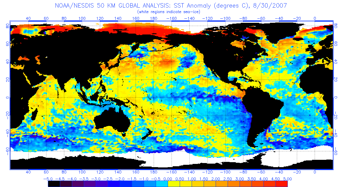
Hard to believe that a year with a 35 ACE July Cat 5 would end up under-performing, but that seems to be where we’re headed. Perhaps Beryl was simply a freak anomaly…which just makes its existence ever more unusual. Perhaps something like 2007: a first year La Niña after a single-year El Niño that produced Cat 5 Caribbean cruisers but not much else of significance and ended up as one of the weakest La Niña hurricane seasons.
The one thing about 2007 is that it was a cool year. Cool in terms of deep tropical sst anomalies. That doesn't seem to be the case this year.
2 likes
Unless explicitly stated, all info in my posts is based on my own opinions and observations. Tropical storms and hurricanes can be extremely dangerous. Refer to an accredited weather research agency or meteorologist if you need to make serious decisions regarding an approaching storm.

Re: 2024 Indicators: SST's, MSLP, Shear, SAL, Steering, Instability (Day 16+ Climate Models)
Category5Kaiju wrote:aspen wrote:I’d say if we reach September 5th with no development expected within the following 2-3 days, then it’s clear that something is wrong with the basin, and another 2022 becomes more likely.
Hard to believe that a year with a 35 ACE July Cat 5 would end up under-performing, but that seems to be where we’re headed. Perhaps Beryl was simply a freak anomaly…which just makes its existence ever more unusual. Perhaps something like 2007: a first year La Niña after a single-year El Niño that produced Cat 5 Caribbean cruisers but not much else of significance and ended up as one of the weakest La Niña hurricane seasons.
The one thing about 2007 is that it was a cool year. Cool in terms of deep tropical sst anomalies. That doesn't seem to be the case this year.
https://www.ospo.noaa.gov/data/sst/anomaly/2007/anomnight.8.30.2007.gif
Yeah in terms of Atlantic SSTAs, it’s the inverse of 2007, which makes their broad stroke similarities odd.
All of the recent notorious bust years — 2007, 2013, 2022, and potentially 2024 — fell short of expectations for very different, unexpected reasons. 2013 had the THC collapse, 2022 had wave-breaking likely tied to the NW Atlantic marine heatwave/displaced high, and 2024 has the hyperactive AEJ/monsoon. I’m not too familiar with 2007 outside of those mediocre SSTAs.
2024 is definitely the most perplexing under-performed because until late July, it looked like it had everything going for it. Although even before the season started, I was suspicious because the indicators looked too good to be true. There had to be some caveat or unseen negative factor…and only now it’s appeared.
6 likes
Irene '11 Sandy '12 Hermine '16 5/15/2018 Derecho Fay '20 Isaias '20 Elsa '21 Henri '21 Ida '21
I am only a meteorology enthusiast who knows a decent amount about tropical cyclones. Look to the professional mets, the NHC, or your local weather office for the best information.
I am only a meteorology enthusiast who knows a decent amount about tropical cyclones. Look to the professional mets, the NHC, or your local weather office for the best information.

Re: 2024 Indicators: SST's, MSLP, Shear, SAL, Steering, Instability (Day 16+ Climate Models)
aspen wrote:Category5Kaiju wrote:aspen wrote:I’d say if we reach September 5th with no development expected within the following 2-3 days, then it’s clear that something is wrong with the basin, and another 2022 becomes more likely.
Hard to believe that a year with a 35 ACE July Cat 5 would end up under-performing, but that seems to be where we’re headed. Perhaps Beryl was simply a freak anomaly…which just makes its existence ever more unusual. Perhaps something like 2007: a first year La Niña after a single-year El Niño that produced Cat 5 Caribbean cruisers but not much else of significance and ended up as one of the weakest La Niña hurricane seasons.
The one thing about 2007 is that it was a cool year. Cool in terms of deep tropical sst anomalies. That doesn't seem to be the case this year.
https://www.ospo.noaa.gov/data/sst/anomaly/2007/anomnight.8.30.2007.gif
Yeah in terms of Atlantic SSTAs, it’s the inverse of 2007, which makes their broad stroke similarities odd.
All of the recent notorious bust years — 2007, 2013, 2022, and potentially 2024 — fell short of expectations for very different, unexpected reasons. 2013 had the THC collapse, 2022 had wave-breaking likely tied to the NW Atlantic marine heatwave/displaced high, and 2024 has the hyperactive AEJ/monsoon. I’m not too familiar with 2007 outside of those mediocre SSTAs.
2024 is definitely the most perplexing under-performed because until late July, it looked like it had everything going for it. Although even before the season started, I was suspicious because the indicators looked too good to be true. There had to be some caveat or unseen negative factor…and only now it’s appeared.
2007 had something to do with the pressure difference or VP anomalies between Indonesia and the western Indian ocean being the inverse of what was needed, but I'm not too familiar with this and can't find the paper off hand (but apparently this was something similar to what led to 2021 shutting down after September)
Regarding the bold, 2022 also had that cold pool just north of the MDR which was contributing both to the wave-breaking, and to the dry air intrusions that led to a storm-free August
2 likes
The above post is not official and should not be used as such. It is the opinion of the poster and may or may not be backed by sound meteorological data. It is not endorsed by any professional institution or storm2k.org. For official information, please refer to the NHC and NWS products.

Re: 2024 Indicators: SST's, MSLP, Shear, SAL, Steering, Instability (Day 16+ Climate Models)
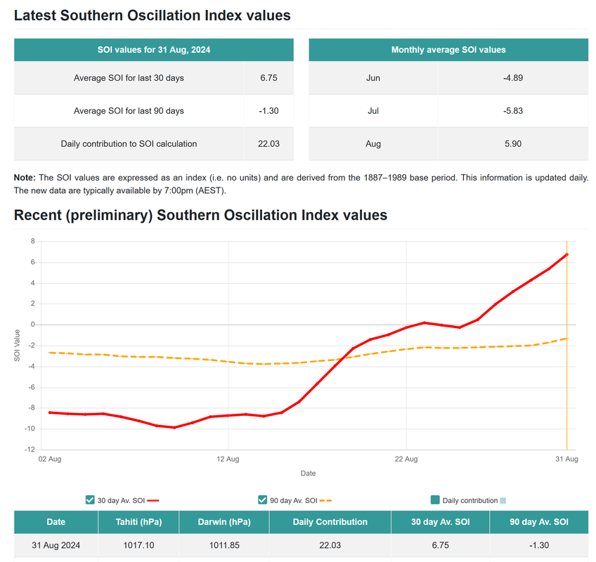
30-day SOI has now completely turned around, rising from around -8 to 6.75 within half a month. This will help with better atmospheric coupling in line with a La Nina.
2 likes
TC naming lists: retirements and intensity
Most aggressive Advisory #1's in North Atlantic (cr. kevin for starting the list)
Most aggressive Advisory #1's in North Atlantic (cr. kevin for starting the list)
Re: 2024 Indicators: SST's, MSLP, Shear, SAL, Steering, Instability (Day 16+ Climate Models)
I think one thing that can safely be said when all is said and done, whether we end up hyperactive or below average, is the models have been functionally useless as far as genesis goes--the constant windshield wiping even within the 72-96 hour period is making even short term trends nearly impossible to determine
6 likes
The above post is not official and should not be used as such. It is the opinion of the poster and may or may not be backed by sound meteorological data. It is not endorsed by any professional institution or storm2k.org. For official information, please refer to the NHC and NWS products.
-
WeatherBoy2000
- Category 1

- Posts: 460
- Joined: Mon Apr 10, 2023 9:29 am
Re: 2024 Indicators: SST's, MSLP, Shear, SAL, Steering, Instability (Day 16+ Climate Models)
Hammy wrote:I think one thing that can safely be said when all is said and done, whether we end up hyperactive or below average, is the models have been functionally useless as far as genesis goes--the constant windshield wiping even within the 72-96 hour period is making even short term trends nearly impossible to determine
I think it's safe to say that when the switch does flip there's going to be little to no warning due to this.
9 likes
-
MarioProtVI
- Category 5
- Posts: 1034
- Age: 24
- Joined: Sun Sep 29, 2019 7:33 pm
- Location: New Jersey
Re: 2024 Indicators: SST's, MSLP, Shear, SAL, Steering, Instability (Day 16+ Climate Models)
Hammy wrote:I think one thing that can safely be said when all is said and done, whether we end up hyperactive or below average, is the models have been functionally useless as far as genesis goes--the constant windshield wiping even within the 72-96 hour period is making even short term trends nearly impossible to determine
Didn’t 2020 have this issue as well with the models? I recall they were especially poor at forecasting genesis and I can’t remember if that was a result of COVID effects limiting data collection to feed into, or they just struggled in general. The most infamous case I can remember was with Laura which models pretty much flopped with all the way until it was starting RI in the Gulf - its track across the entire chain of Antilles and managing to survive because of its broadness might’ve especially contributed to that performance (dissipating too quickly). The Euro wasn’t even on board for a coherent Laura until it was already a strengthening hurricane!
4 likes
-
dexterlabio
- Category 5
- Posts: 3501
- Joined: Sat Oct 24, 2009 11:50 pm
Re: 2024 Indicators: SST's, MSLP, Shear, SAL, Steering, Instability (Day 16+ Climate Models)
2007 and 2022 might be bust years in La Niña standards but they are far from a below average hurricane season.
2 likes
Personal Forecast Disclaimer:
The posts in this forum are NOT official forecast and should not be used as such. They are just the opinion of the poster and may or may not be backed by sound meteorological data. They are NOT endorsed by any professional institution or storm2k.org. For official information, please refer to the NHC and NWS products.
The posts in this forum are NOT official forecast and should not be used as such. They are just the opinion of the poster and may or may not be backed by sound meteorological data. They are NOT endorsed by any professional institution or storm2k.org. For official information, please refer to the NHC and NWS products.
Re: 2024 Indicators: SST's, MSLP, Shear, SAL, Steering, Instability (Day 16+ Climate Models)
dexterlabio wrote:2007 and 2022 might be bust years in La Niña standards but they are far from a below average hurricane season.
2007 is nearly 20 points below the average ACE
0 likes
The above post is not official and should not be used as such. It is the opinion of the poster and may or may not be backed by sound meteorological data. It is not endorsed by any professional institution or storm2k.org. For official information, please refer to the NHC and NWS products.
Re: 2024 Indicators: SST's, MSLP, Shear, SAL, Steering, Instability (Day 16+ Climate Models)
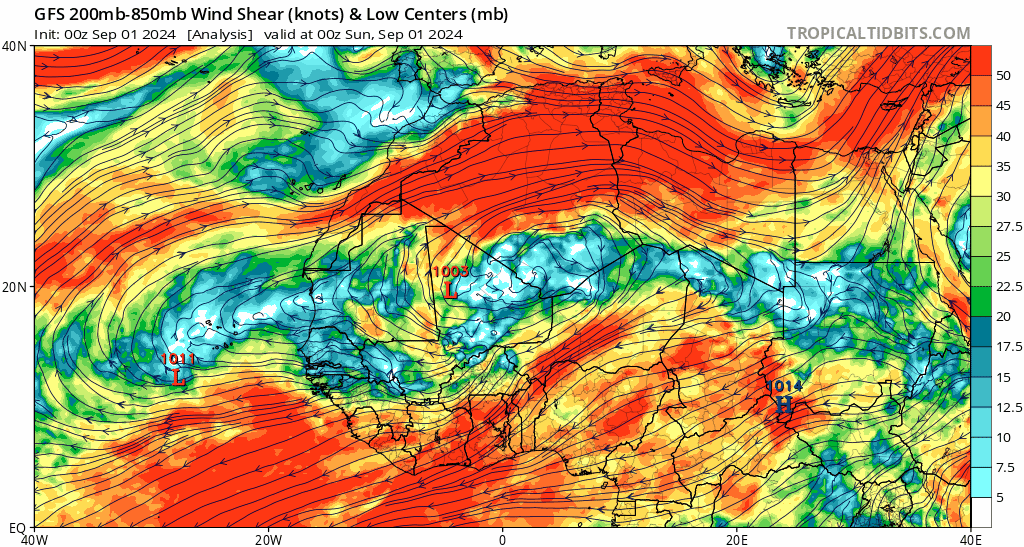
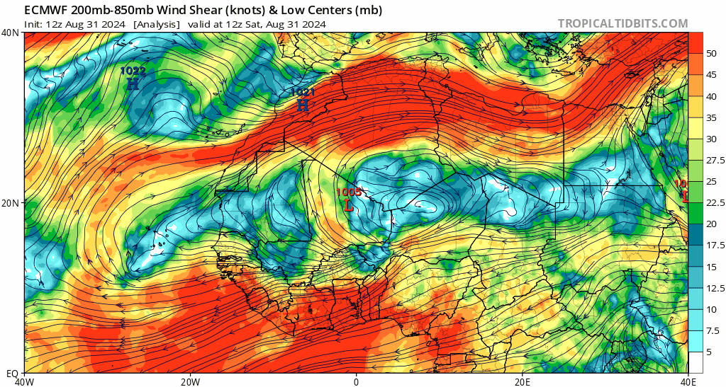
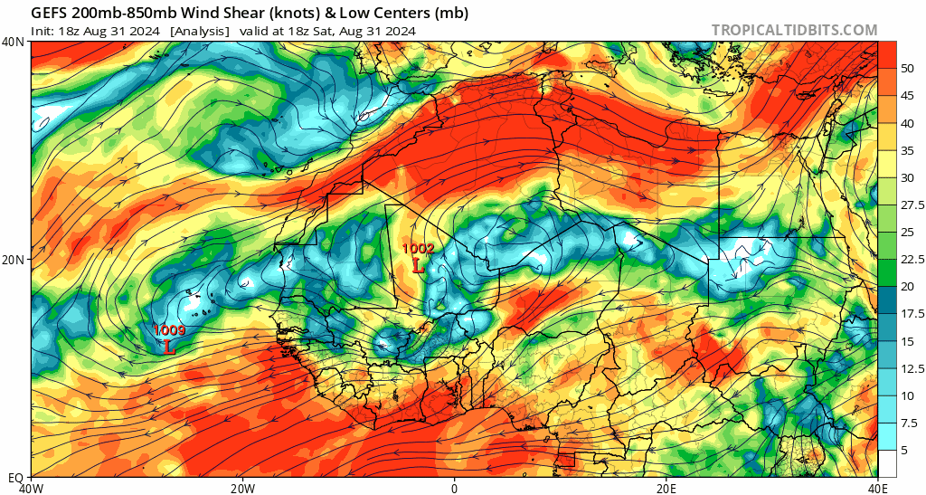
Models are suggesting a reduction in shear in the eastern MDR from the AEJ as we head into the climo peak. September 6 seems to be the date when the overall magnitude of shear over eastern Atlantic and Africa becomes greatly reduced. This has been showing up on ensemble means for 1-2 weeks*, but now operational GFS and ECMWF are also on board (and any remaining high shear on the runs seem wave-induced to me).
* Ensemble means do have the phenomenon where indicators like these get "washed out" or become lower in magnitude due to higher variance. Possibly because of this, GEFS and EPS had been "pushing back" the date for AEJ shear reduction earlier, as they were showing September 1 about a week ago. But the fact that operationals are now on board makes the ensemble means more believable.

* Ensemble means do have the phenomenon where indicators like these get "washed out" or become lower in magnitude due to higher variance. Possibly because of this, GEFS and EPS had been "pushing back" the date for AEJ shear reduction earlier, as they were showing September 1 about a week ago. But the fact that operationals are now on board makes the ensemble means more believable.
0 likes
TC naming lists: retirements and intensity
Most aggressive Advisory #1's in North Atlantic (cr. kevin for starting the list)
Most aggressive Advisory #1's in North Atlantic (cr. kevin for starting the list)
-
SFLcane

- S2K Supporter

- Posts: 10281
- Age: 48
- Joined: Sat Jun 05, 2010 1:44 pm
- Location: Lake Worth Florida
Re: 2024 Indicators: SST's, MSLP, Shear, SAL, Steering, Instability (Day 16+ Climate Models)
There is 3 months to go in hurricane season so the chance of a heavy backloaded yr is surely there. I'd be even more shocked if october isnt busy in the carib with la nina getting stronger.
1 likes
-
MarioProtVI
- Category 5
- Posts: 1034
- Age: 24
- Joined: Sun Sep 29, 2019 7:33 pm
- Location: New Jersey
Re: 2024 Indicators: SST's, MSLP, Shear, SAL, Steering, Instability (Day 16+ Climate Models)
When people like Eric Webb say this, you know the season has failed spectacularly.
I have never seen such a perfect setup for the basin for such a hyperactive season gone to complete waste by peak season and struggle immensely. This really is another 2013, and the 2022 comparisons are going out the window because unlike 2022, 2024 seems like it will remain dead or very weak through peak season. At this rate, we may not even make it to above average or even over 100 ACE at the rate this season is going. So many forecasts are going to bust HARD and agencies are going to receive a lot of backlash and lose a lot of trust in the off-season as well as funding. Would not be surprised if agencies like CSU stop issuing forecasts because of the catastrophic bust on the forecast.
2 likes

Re: 2024 Indicators: SST's, MSLP, Shear, SAL, Steering, Instability (Day 16+ Climate Models)
Did the ITCZ ever shift south or is it still way north so nothing is developing. Also NE trades over northwest Africa is causing the lack of storms as well.I wonder if the season will change or will it be similar to 2013.
0 likes
-
Category5Kaiju
- Category 5
- Posts: 4330
- Joined: Thu Dec 24, 2020 12:45 pm
- Location: Seattle and Phoenix
Re: 2024 Indicators: SST's, MSLP, Shear, SAL, Steering, Instability (Day 16+ Climate Models)
Just want to preface this comment by saying it's such an honor to be a part of this community and take part in discussions regarding hurricane season.
I'm going on a several weeks-long vacation out of town, and between my busy personal life and how there doesn't really seem to be much happening out there in the tropics as of yet, I'm going to be taking a break from tracking the tropics. Don't worry though, I hope to be back soon
Before I leave, I'm going to say this: hurricanes are mysterious. Yes, you heard that right. Mysterious in the sense that we still have much to learn about them. How they rapidly intensify, the tracks they take, and, as it may relate to this season in particular, what ingredients they need to form. And that's what makes what we do here so invaluable.
And regarding my thoughts about this season so far....I do think certain parameters are going to bust badly. I think there are a series of factors that came into play in late August that totally threw many of us, even seasoned experts, off guard. How the rest of the season plays out until November 30 is anybody's guess. However, this season has also been remarkable in certain aspects. It managed to produce Beryl (which broke so many records and was a storm that seems to have been spawned out of one of those "hypothetical hurricane season" Youtube videos). It also already delivered 2 CONUS hurricane strikes, with all storms impacting land in some fashion. Whatever happens going forward, we're definitely going to be referring to 2024 in future years. Maybe due to its underperformance. Or maybe due to its roaring comeback in late September onward. Who knows? We can only track in real time.
4 likes
Unless explicitly stated, all info in my posts is based on my own opinions and observations. Tropical storms and hurricanes can be extremely dangerous. Refer to an accredited weather research agency or meteorologist if you need to make serious decisions regarding an approaching storm.
-
WeatherBoy2000
- Category 1
- Posts: 460
- Joined: Mon Apr 10, 2023 9:29 am
Re: 2024 Indicators: SST's, MSLP, Shear, SAL, Steering, Instability (Day 16+ Climate Models)
MarioProtVI wrote:
When people like Eric Webb say this, you know the season has failed spectacularly.
I have never seen such a perfect setup for the basin for such a hyperactive season gone to complete waste by peak season and struggle immensely. This really is another 2013, and the 2022 comparisons are going out the window because unlike 2022, 2024 seems like it will remain dead or very weak through peak season. At this rate, we may not even make it to above average or even over 100 ACE at the rate this season is going. So many forecasts are going to bust HARD and agencies are going to receive a lot of backlash and lose a lot of trust in the off-season as well as funding. Would not be surprised if agencies like CSU stop issuing forecasts because of the catastrophic bust on the forecast.
Unless things really turn around the forecasting agencies will likely take a reputation hit. I can't blame them for producing the forecasts that they did because it did look like the perfect set up. With that said, CSU was still able to recover from 2013 which was still a worse bust than 2024. I don't see seasonal forecasts going away because they are at least important for research purposes, this season just shows that we still have a lot to learn.
0 likes

Re: 2024 Indicators: SST's, MSLP, Shear, SAL, Steering, Instability (Day 16+ Climate Models)
I don’t really understand the 2013 comparisons. Yes, it was predicted to be above normal and busted due to a mysterious suppressing force, but in terms of seasonal stats 2024 won’t be similar at all. We’ve already had more hurricanes than 2013, one of them being a major when 2013 had none. Not only was it a major, it was a cat 5. I do think this season will be a bust, potentially a significant bust, in terms of numbers but I would be extremely surprised if we didn’t get one or two more major and/or impactful hurricanes before the season is over.
6 likes
Igor 2010, Sandy 2012, Fay 2014, Gonzalo 2014, Joaquin 2015, Nicole 2016, Humberto 2019, Imelda 2025
I am only a tropical weather enthusiast. My predictions are not official and may or may not be backed by sound meteorological data. For official information, please refer to the NHC and NWS products.
I am only a tropical weather enthusiast. My predictions are not official and may or may not be backed by sound meteorological data. For official information, please refer to the NHC and NWS products.
-
WeatherBoy2000
- Category 1
- Posts: 460
- Joined: Mon Apr 10, 2023 9:29 am
Re: 2024 Indicators: SST's, MSLP, Shear, SAL, Steering, Instability (Day 16+ Climate Models)
At this rate we're in for the biggest forecasting bust since 2013 despite what has already been produced. It's important to point out that this year's forecasts were much more bullish than 2013's. No season is ever the same which means no season busts in the same way. It's only September 1st, we could still get some big storms even if it isn't the "next 2005" or whatever.
0 likes
-
WaveBreaking

- Category 2

- Posts: 717
- Joined: Sun Jun 30, 2024 11:33 am
- Location: US
Re: 2024 Indicators: SST's, MSLP, Shear, SAL, Steering, Instability (Day 16+ Climate Models)
IMO, this season might pull off a repeat of 2022’s lull period, except the lull will be delayed by a few weeks.
The current SST configuration resembles that of 2022 during the same time period, complete with the (shifted east) high-latitude warm blob and the relatively cool tongue of waters near the African coast. It seems that this year, however, the dry air problems are more to the east near the African coast, which has worked in tandem with the hyperactive African Monsoon to starve any waves of convection and/or concentrated vorticity.

One thing that also caught my eye is how 2024’s SST configuration changed from something resembling 2005’s in July to something closer to 2022’s configuration in late August/Early September. The warm blob also shifted to the SE during this timeframe, which is probably why dry air wasn’t so much of an issue in early August compared to now.

If we assume that this year does in fact follow 2022’s progression from now on, then we still shouldn’t let our guard down (i.e., Fiona and Ian). The key differences this year (1st-year cool neutral instead of 3rd-year moderate La Niña; any possible effects from the Hunga-Tonga eruption being less prominent due to the stratosphere recovering from the influx of water vapor) might mean that once the now-delayed switch does flip, then the spike in activity like we saw in September 2022 will likely last just as long or even long than 2022’s.
The current SST configuration resembles that of 2022 during the same time period, complete with the (shifted east) high-latitude warm blob and the relatively cool tongue of waters near the African coast. It seems that this year, however, the dry air problems are more to the east near the African coast, which has worked in tandem with the hyperactive African Monsoon to starve any waves of convection and/or concentrated vorticity.
One thing that also caught my eye is how 2024’s SST configuration changed from something resembling 2005’s in July to something closer to 2022’s configuration in late August/Early September. The warm blob also shifted to the SE during this timeframe, which is probably why dry air wasn’t so much of an issue in early August compared to now.
If we assume that this year does in fact follow 2022’s progression from now on, then we still shouldn’t let our guard down (i.e., Fiona and Ian). The key differences this year (1st-year cool neutral instead of 3rd-year moderate La Niña; any possible effects from the Hunga-Tonga eruption being less prominent due to the stratosphere recovering from the influx of water vapor) might mean that once the now-delayed switch does flip, then the spike in activity like we saw in September 2022 will likely last just as long or even long than 2022’s.
3 likes
I am NOT a professional meteorologist, so take all of my posts with a grain of salt. My opinions are mine and mine alone.
Who is online
Users browsing this forum: kevin, mixedDanilo.E and 73 guests