Why is the 2024 Atlantic hurricane season underperforming expectations?

This is the general tropical discussion area. Anyone can take their shot at predicting a storms path.

Moderator: S2k Moderators

Forum rules

The posts in this forum are NOT official forecasts and should not be used as such. They are just the opinion of the poster and may or may not be backed by sound meteorological data. They are NOT endorsed by any professional institution or STORM2K. For official information, please refer to products from the National Hurricane Center and National Weather Service.

Help Support Storm2K
Message
Author
User avatar
CyclonicFury
Category 5
Category 5
Posts: 2019
Age: 26
Joined: Sun Jul 02, 2017 12:32 pm
Location: NC
Contact:

Re: The baffling late August Atlantic shutdown of 2024

#41 Postby CyclonicFury » Sun Sep 01, 2024 12:15 pm

psyclone wrote:The risk now is people overshooting to the downside. Anything that is extremely anomalous is unlikely to persist. The current dead streak is insanely anomalous. I'd bet it finds a way to end. Just as forecasting a record season. That too is extremely anomalous and will likely find a way to not happen. As it stands now we have 2 extremely high risk months to tiptoe through. Will nothing continue to happen? Perhaps. But that would be a crazy extreme and I'd take the opposite side of that bet. If you're in the Caribbean, central or east Gulf ...in many of those areas the highest climo risk remains ahead. We're dancing through a minefield right now but we have a long way to go and the risk of a high impact event(s) remains substantial...IMO.

This is very true. The Atlantic has proven favorable enough to produce 3 hurricanes (and an unprecedented early July Category 5) already, but there's no doubt this ongoing dead period since bell ringing day has been very anomalous. Usually instability increases in September and October, so if that's really what has been the culprit for the lack of activity, we could see a busy late season. Unlike 2013 and 2022, shear has been well below normal in most of the deep tropics. Just because the very high numbers are on track to bust doesn't mean that the Atlantic is going to stay as hostile and quiet as it currently is now.
4 likes   
NCSU B.S. in Meteorology Class of 2021. Tropical weather blogger at http://www.cyclonicfury.com. My forecasts and thoughts are NOT official, for official forecasts please consult the National Hurricane Center.

User avatar
cycloneye
Admin
Admin
Posts: 143865
Age: 68
Joined: Thu Oct 10, 2002 10:54 am
Location: San Juan, Puerto Rico

Re: The baffling late August Atlantic shutdown of 2024

#42 Postby cycloneye » Sun Sep 01, 2024 12:17 pm

2 likes   
Visit the Caribbean-Central America Weather Thread where you can find at first post web cams,radars
and observations from Caribbean basin members Click Here

User avatar
CyclonicFury
Category 5
Category 5
Posts: 2019
Age: 26
Joined: Sun Jul 02, 2017 12:32 pm
Location: NC
Contact:

Re: The baffling late August Atlantic shutdown of 2024

#43 Postby CyclonicFury » Sun Sep 01, 2024 12:55 pm

This season is slipping fast in its ranks. At one point, the NATL was at #3 in ACE on record through around the time of Ernesto's dissipation. Since, the NATL has fallen to 13th, but could be at risk of even falling below average if the basin does not wake up soon.

In addition, the number of storm formations this season has been legitimately unimpressive: thus far, the NATL has only seen 5 named storms, which is actually below the 1991-2020 average of 6.6. The NATL has also fallen slightly below average in named storm days, and is likely to fall even further below average in the coming days. The NATL has fallen behind below-average seasons like 2013 and 2015 in named storms, and is likely to fall behind 2006 in just 2 days. It's still so baffling: you would think with an early July Category 5 in the deep tropics, well below average shear, and well above average tropical Atlantic SSTs, 2024 would be a slam dunk for a hyperactive season but it just hasn't been so far. The Atlantic hasn't even gone through the entire rotation of invest numbers yet!
10 likes   
NCSU B.S. in Meteorology Class of 2021. Tropical weather blogger at http://www.cyclonicfury.com. My forecasts and thoughts are NOT official, for official forecasts please consult the National Hurricane Center.

User avatar
aspen
Category 5
Category 5
Posts: 8812
Joined: Sat Oct 12, 2019 7:10 pm
Location: Connecticut, USA

Re: The baffling late August Atlantic shutdown of 2024

#44 Postby aspen » Sun Sep 01, 2024 1:00 pm

CyclonicFury wrote:This season is slipping fast in its ranks. At one point, the NATL was at #3 in ACE on record through around the time of Ernesto's dissipation. Since, the NATL has fallen to 13th, but could be at risk of even falling below average if the basin does not wake up soon.

In addition, the number of storm formations this season has been legitimately unimpressive: thus far, the NATL has only seen 5 named storms, which is actually below the 1991-2020 average of 6.6. The NATL has also fallen slightly below average in named storm days, and is likely to fall even further below average in the coming days. The NATL has fallen behind below-average seasons like 2013 and 2015 in named storms, and is likely to fall behind 2006 in just 2 days. It's still so baffling: you would think with an early July Category 5 in the deep tropics, well below average shear, and well above average tropical Atlantic SSTs, 2024 would be a slam dunk for a hyperactive season but it just hasn't been so far. The Atlantic hasn't even gone through the entire rotation of invest numbers yet!

The existence of Beryl contrasting with the incredibly tame numbers afterwards is baffling. This would suggest Beryl was a freak anomaly and not an indicator of peak season activity, but then that just makes it ever weirder. How were conditions in late June/early July so conducive for TCG, but so mediocre during August/early September, even with a +AMO, transitioning -ENSO, and favorable MJO phases? Sure we got 2 hurricanes, but nothing since Ernesto. And while we know the hyperactive AEJ is part of the problem the Atlantic is facing, why wasn’t it an issue when Beryl formed?
2 likes   
Irene '11 Sandy '12 Hermine '16 5/15/2018 Derecho Fay '20 Isaias '20 Elsa '21 Henri '21 Ida '21

I am only a meteorology enthusiast who knows a decent amount about tropical cyclones. Look to the professional mets, the NHC, or your local weather office for the best information.

User avatar
drezee
S2K Supporter
S2K Supporter
Posts: 3664
Joined: Mon Jun 09, 2003 12:49 pm
Location: FL

Re: The baffling late August Atlantic shutdown of 2024

#45 Postby drezee » Sun Sep 01, 2024 1:03 pm

0 likes   

User avatar
Hammy
Category 5
Category 5
Posts: 5849
Age: 41
Joined: Fri May 25, 2012 5:25 pm
Contact:

Re: The baffling late August Atlantic shutdown of 2024

#46 Postby Hammy » Sun Sep 01, 2024 1:11 pm

aspen wrote:
CyclonicFury wrote:This season is slipping fast in its ranks. At one point, the NATL was at #3 in ACE on record through around the time of Ernesto's dissipation. Since, the NATL has fallen to 13th, but could be at risk of even falling below average if the basin does not wake up soon.

In addition, the number of storm formations this season has been legitimately unimpressive: thus far, the NATL has only seen 5 named storms, which is actually below the 1991-2020 average of 6.6. The NATL has also fallen slightly below average in named storm days, and is likely to fall even further below average in the coming days. The NATL has fallen behind below-average seasons like 2013 and 2015 in named storms, and is likely to fall behind 2006 in just 2 days. It's still so baffling: you would think with an early July Category 5 in the deep tropics, well below average shear, and well above average tropical Atlantic SSTs, 2024 would be a slam dunk for a hyperactive season but it just hasn't been so far. The Atlantic hasn't even gone through the entire rotation of invest numbers yet!

The existence of Beryl contrasting with the incredibly tame numbers afterwards is baffling. This would suggest Beryl was a freak anomaly and not an indicator of peak season activity, but then that just makes it ever weirder. How were conditions in late June/early July so conducive for TCG, but so mediocre during August/early September, even with a +AMO, transitioning -ENSO, and favorable MJO phases? Sure we got 2 hurricanes, but nothing since Ernesto. And while we know the hyperactive AEJ is part of the problem the Atlantic is facing, why wasn’t it an issue when Beryl formed?


I wouldn't say that--last year, we had two storms in June in the MDR, and the season had a lot of storms being flung NW over the eastern and central Atlantic. This year, we had a Cat 4 in the MDR (at a slightly higher latitude than those storms developed, and clearly much stronger) and it was an indicator, but not of what we thought--it was an indicator of just how much farther north than typical the ITCZ was, and a learning experience that if we see a repeat, we may very well see a similar repeat of how the peak of the season is behaving.
2 likes   
The above post is not official and should not be used as such. It is the opinion of the poster and may or may not be backed by sound meteorological data. It is not endorsed by any professional institution or storm2k.org. For official information, please refer to the NHC and NWS products.

LarryWx
Category 5
Category 5
Posts: 6246
Joined: Sun Sep 07, 2003 2:04 pm
Location: GA

Re: The baffling late August Atlantic shutdown of 2024

#47 Postby LarryWx » Sun Sep 01, 2024 1:18 pm

What about the current very active sunspots and a possible lag to consider as possibly one of the main factors keeping things quiet recently? Aug of 2024 had a 216, the highest mean sunspots in Aug since 1991. That means that this Aug had the highest mean for Aug of the current active era so far.

https://www.sidc.be/SILSO/DATA/SN_m_tot_V2.0.txt

Per met. Joe D’Aleo:
“We have mentioned the strong solar spike which research has shown can suppress hurricane activity.”

“One negative may be the big spike in solar in cycle 25. Most cycles have had a dual max and recent ones had the second one higher. This warms the upper atmosphere and hampers development.”
1 likes   
Personal Forecast Disclaimer:
The posts in this forum are NOT official forecasts and should not be used as such. They are just the opinion of the poster and may or may not be backed by sound meteorological data. They are NOT endorsed by any professional institution or storm2k.org. For official information, please refer to the NHC and NWS products.

IcyTundra
Category 5
Category 5
Posts: 1205
Joined: Mon Jun 07, 2021 9:32 pm
Location: Dickinson, Texas

Re: The baffling late August Atlantic shutdown of 2024

#48 Postby IcyTundra » Sun Sep 01, 2024 1:31 pm

LarryWx wrote:What about the current very active sunspots and a possible lag to consider as possibly one of the main factors keeping things quiet recently? Aug of 2024 had a 216, the highest mean sunspots in Aug since 1991. That means that this Aug had the highest mean for Aug of the current active era so far.

https://www.sidc.be/SILSO/DATA/SN_m_tot_V2.0.txt

Per met. Joe D’Aleo:
“We have mentioned the strong solar spike which research has shown can suppress hurricane activity.”

“One negative may be the big spike in solar in cycle 25. Most cycles have had a dual max and recent ones had the second one higher. This warms the upper atmosphere and hampers development.”


Is there any papers that discuss any potential connection between solar activity and hurricane seasons? I've seen a few people mention this as a possibility but it seems like most mets believe there is no connection. I am personally skeptical but would be interesting to hear an argument that supports it.
2 likes   

WeatherBoy2000
Category 1
Category 1
Posts: 280
Joined: Mon Apr 10, 2023 9:29 am

Re: The baffling late August Atlantic shutdown of 2024

#49 Postby WeatherBoy2000 » Sun Sep 01, 2024 1:43 pm

CyclonicFury wrote:This season is slipping fast in its ranks. At one point, the NATL was at #3 in ACE on record through around the time of Ernesto's dissipation. Since, the NATL has fallen to 13th, but could be at risk of even falling below average if the basin does not wake up soon.

In addition, the number of storm formations this season has been legitimately unimpressive: thus far, the NATL has only seen 5 named storms, which is actually below the 1991-2020 average of 6.6. The NATL has also fallen slightly below average in named storm days, and is likely to fall even further below average in the coming days. The NATL has fallen behind below-average seasons like 2013 and 2015 in named storms, and is likely to fall behind 2006 in just 2 days. It's still so baffling: you would think with an early July Category 5 in the deep tropics, well below average shear, and well above average tropical Atlantic SSTs, 2024 would be a slam dunk for a hyperactive season but it just hasn't been so far. The Atlantic hasn't even gone through the entire rotation of invest numbers yet!


I think it goes to show that dry air is more of a killer than shear. Shear could be literally nothing but if it's dry as bone then nothing will form.
0 likes   

User avatar
Teban54
Category 5
Category 5
Posts: 3168
Joined: Sat May 19, 2018 1:19 pm

Re: The baffling late August Atlantic shutdown of 2024

#50 Postby Teban54 » Sun Sep 01, 2024 2:00 pm

WeatherBoy2000 wrote:
CyclonicFury wrote:This season is slipping fast in its ranks. At one point, the NATL was at #3 in ACE on record through around the time of Ernesto's dissipation. Since, the NATL has fallen to 13th, but could be at risk of even falling below average if the basin does not wake up soon.

In addition, the number of storm formations this season has been legitimately unimpressive: thus far, the NATL has only seen 5 named storms, which is actually below the 1991-2020 average of 6.6. The NATL has also fallen slightly below average in named storm days, and is likely to fall even further below average in the coming days. The NATL has fallen behind below-average seasons like 2013 and 2015 in named storms, and is likely to fall behind 2006 in just 2 days. It's still so baffling: you would think with an early July Category 5 in the deep tropics, well below average shear, and well above average tropical Atlantic SSTs, 2024 would be a slam dunk for a hyperactive season but it just hasn't been so far. The Atlantic hasn't even gone through the entire rotation of invest numbers yet!


I think it goes to show that dry air is more of a killer than shear. Shear could be literally nothing but if it's dry as bone then nothing will form.

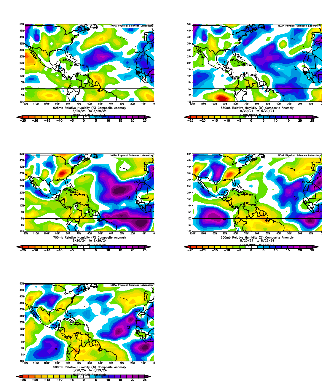
Data from August 20-29 shows the basin wasn't nearly as anomalously dry as every comment here is suggesting, though. Can someone please explain the discrepancy or point out what I was doing wrong here, before we take "dry air killing the basin" as a given? I'm genuinely lost, because it feels increasingly like the charts below go against everything else I've seen.

Image
3 likes   

User avatar
Spacecoast
Category 2
Category 2
Posts: 758
Joined: Thu Aug 31, 2017 2:03 pm

Re: The baffling late August Atlantic shutdown of 2024

#51 Postby Spacecoast » Sun Sep 01, 2024 3:29 pm

So far, it doesn't look like an explosive, supercharged, season from Hell (non-meteorological terms, btw). Perhaps next year we can dispense with the hyperbole.

However, it has been an unusually impactful season with almost all the ACE occurring West of 60°W, (probably greater than 90%), resulting in 5 out of 5 landfalling storms.
Regardless of the number of storms, (or intensity) the remainder of the season still looks to be very impactful.
Debbie has demonstrated the impact of a stalled out TS/TD.
A lesson I learned in 2008 when Fay parked over my house for 4-5 days, and dropped ~28 inches of rain.
2 likes   

User avatar
chaser1
S2K Supporter
S2K Supporter
Posts: 5407
Age: 64
Joined: Sat Oct 15, 2005 5:59 pm
Location: Longwood, Fl

Re: The baffling late August Atlantic shutdown of 2024

#52 Postby chaser1 » Sun Sep 01, 2024 3:57 pm

LarryWx wrote:What about the current very active sunspots and a possible lag to consider as possibly one of the main factors keeping things quiet recently? Aug of 2024 had a 216, the highest mean sunspots in Aug since 1991. That means that this Aug had the highest mean for Aug of the current active era so far.

https://www.sidc.be/SILSO/DATA/SN_m_tot_V2.0.txt

Per met. Joe D’Aleo:
“We have mentioned the strong solar spike which research has shown can suppress hurricane activity.”

“One negative may be the big spike in solar in cycle 25. Most cycles have had a dual max and recent ones had the second one higher. This warms the upper atmosphere and hampers development.”


Thanks Larry, this is interesting stuff. A little outside the box, but very interesting. Years ago I probably would have been apt to discount the possibility of a significant connection to solar activity but THIS YEAR??? Some truly significant force has to be playing a roll, and it would make sense for that causation to have been entirely out of left field given the broadly unanimous hyperactive season predictions. When I say significant I mean a basinwide causation greater then marginally low humidifier, SAL, or ENSO pattern. Naturally many are grasping at straws to make sense of the tropical quiet especially in light of expectations but I do not believe that a persistant African monsoonal flow OR higher latitude than average ITCZ has much if anything to do with the current Atlantic shut-down (for reasons that I'll outline in another post). There has been some recent conversation regarding the warming of Earth's upper atmosphere though i've had no opportunity to read up further about the hypothesis and potential clamp down on tropical activity that remains in place for the time being. Solar forcing seems to make a little more sense (to me) than global warming simply because the former would suggest a top-down impact where the latter would seem to be something better anticipated and foreseeable.
2 likes   
Andy D

(For official information, please refer to the NHC and NWS products.)

User avatar
ConvergenceZone
Category 5
Category 5
Posts: 5194
Joined: Fri Jul 29, 2005 1:40 am
Location: Northern California

Re: The baffling late August Atlantic shutdown of 2024

#53 Postby ConvergenceZone » Sun Sep 01, 2024 3:59 pm

I went ahead and cancelled my FrndlyTV subscription. I usually get it once a year so that I can watch the weather channel since I don't have cable and they have such amazing landfalling storm footage. I figure that if things pick up by the end of the month or maybe in early October I can always re-instate the plan. Although I would only re-instate if there was a big threat to the USA since that's footage starts. So thanks tropics for saving me some money :)
2 likes   

User avatar
chaser1
S2K Supporter
S2K Supporter
Posts: 5407
Age: 64
Joined: Sat Oct 15, 2005 5:59 pm
Location: Longwood, Fl

Re: The baffling late August Atlantic shutdown of 2024

#54 Postby chaser1 » Sun Sep 01, 2024 4:07 pm

Teban54 wrote:
WeatherBoy2000 wrote:
CyclonicFury wrote:This season is slipping fast in its ranks. At one point, the NATL was at #3 in ACE on record through around the time of Ernesto's dissipation. Since, the NATL has fallen to 13th, but could be at risk of even falling below average if the basin does not wake up soon.

In addition, the number of storm formations this season has been legitimately unimpressive: thus far, the NATL has only seen 5 named storms, which is actually below the 1991-2020 average of 6.6. The NATL has also fallen slightly below average in named storm days, and is likely to fall even further below average in the coming days. The NATL has fallen behind below-average seasons like 2013 and 2015 in named storms, and is likely to fall behind 2006 in just 2 days. It's still so baffling: you would think with an early July Category 5 in the deep tropics, well below average shear, and well above average tropical Atlantic SSTs, 2024 would be a slam dunk for a hyperactive season but it just hasn't been so far. The Atlantic hasn't even gone through the entire rotation of invest numbers yet!


I think it goes to show that dry air is more of a killer than shear. Shear could be literally nothing but if it's dry as bone then nothing will form.

Data from August 20-29 shows the basin wasn't nearly as anomalously dry as every comment here is suggesting, though. Can someone please explain the discrepancy or point out what I was doing wrong here, before we take "dry air killing the basin" as a given? I'm genuinely lost, because it feels increasingly like the charts below go against everything else I've seen.

https://i.postimg.cc/d0FJqTxJ/ezgif-com-animated-gif-maker-2.gif


Per the graphics shown (during the period shown) the Caribbean certainly did appear dry at 500mb, 600mb, and 700mb. To your point, the same could not be said for the Eastern Atlantic where those layers were seemingly moist. However, what about above those heights? I'd be curious to see the same graphic for 200-300 mb levels.
0 likes   
Andy D

(For official information, please refer to the NHC and NWS products.)

User avatar
Teban54
Category 5
Category 5
Posts: 3168
Joined: Sat May 19, 2018 1:19 pm

Re: The baffling late August Atlantic shutdown of 2024

#55 Postby Teban54 » Sun Sep 01, 2024 4:15 pm

chaser1 wrote:
Teban54 wrote:
WeatherBoy2000 wrote:
I think it goes to show that dry air is more of a killer than shear. Shear could be literally nothing but if it's dry as bone then nothing will form.

Data from August 20-29 shows the basin wasn't nearly as anomalously dry as every comment here is suggesting, though. Can someone please explain the discrepancy or point out what I was doing wrong here, before we take "dry air killing the basin" as a given? I'm genuinely lost, because it feels increasingly like the charts below go against everything else I've seen.

https://i.postimg.cc/d0FJqTxJ/ezgif-com-animated-gif-maker-2.gif


Per the graphics shown (during the period shown) the Caribbean certainly did appear dry at 500mb, 600mb, and 700mb. To your point, the same could not be said for the Eastern Atlantic where those layers were seemingly moist. However, what about above those heights? I'd be curious to see the same graphic for 200-300 mb levels.

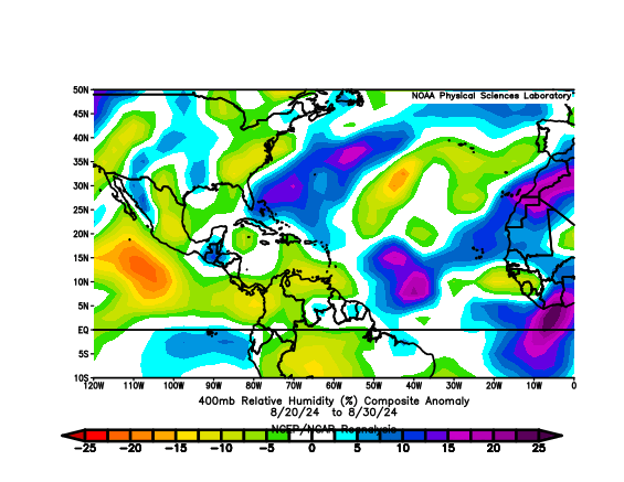
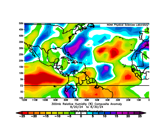
Good point. I didn't make it a GIF, but here are the 400mb and 300mb plots (the data goes up to 300 only). They do show a drier MDR than 500-925 mb, but the only one that seems particularly bad is 300 mb. At that point, we're obviously not talking about "mid-level" dry air, much less SAL, that people seem to reference a lot in the past week. It also seems related to upper-level patterns there: The driest spot on the 300mb chart, which is just north of the MDR, coincides with the eastward-displaced Azores-Bermuda High that has been in place for most of August.

Image

Image
0 likes   

TomballEd
Category 2
Category 2
Posts: 580
Age: 61
Joined: Wed Aug 16, 2023 4:52 pm
Location: Spring/Klein area, not Tomball

Re: The baffling late August Atlantic shutdown of 2024

#56 Postby TomballEd » Sun Sep 01, 2024 4:20 pm

Sub Tropical development can affect the US in the early season into September. The late September-October STCs are usually above 30N, and never a threat to anyplace but the Azores, or Europe as a post tropical storm.

The systems that do matter come from the tropics late season, and I wonder if (I really can't think of a good way to explain it) the late September to November end of the season might be a reflection of the June-July early season. That is, Ian like threats end of September into October (sandy) like threats are still possible for the Eastern Gulf/Florida and maybe even ECUSA. I think the number of named storms may not reach 15 this year, but we've already had 2 US mainland hits, and a damaging Puerto Rico storm, and may have one or two more.
0 likes   

CrazyC83
Professional-Met
Professional-Met
Posts: 34001
Joined: Tue Mar 07, 2006 11:57 pm
Location: Deep South, for the first time!

Re: The baffling late August Atlantic shutdown of 2024

#57 Postby CrazyC83 » Sun Sep 01, 2024 5:00 pm

It seems what is happening is there are so few waves out there. Those that CAN get going are taking off well (Beryl, Debby, Ernesto) but we aren't seeing the shorties or the over-abundance of waves.
2 likes   

User avatar
Hammy
Category 5
Category 5
Posts: 5849
Age: 41
Joined: Fri May 25, 2012 5:25 pm
Contact:

Re: The baffling late August Atlantic shutdown of 2024

#58 Postby Hammy » Sun Sep 01, 2024 5:07 pm

CrazyC83 wrote:It seems what is happening is there are so few waves out there. Those that CAN get going are taking off well (Beryl, Debby, Ernesto) but we aren't seeing the shorties or the over-abundance of waves.


Is this resulting from the monsoon overamplification?
0 likes   
The above post is not official and should not be used as such. It is the opinion of the poster and may or may not be backed by sound meteorological data. It is not endorsed by any professional institution or storm2k.org. For official information, please refer to the NHC and NWS products.

User avatar
Blown Away
S2K Supporter
S2K Supporter
Posts: 10140
Joined: Wed May 26, 2004 6:17 am

Re: The baffling late August-early September Atlantic shutdown of 2024

#59 Postby Blown Away » Sun Sep 01, 2024 6:38 pm

Been on this board for decades, the fact the GFS really has nothing up to Sept 17 is absolutely fascinating… So intrigued if this underwhelming season plays out how it’s explained and how this seasons information is used for future predictions… So interesting…
3 likes   
Hurricane Eye Experience: David 79, Irene 99, Frances 04, Jeanne 04, Wilma 05... EYE COMING MY WAY IN 2024…
Hurricane Brush Experience: Andrew 92, Erin 95, Floyd 99, Matthew 16, Irma 17, Ian 22, Nicole 22…

User avatar
cajungal
Category 5
Category 5
Posts: 2327
Age: 48
Joined: Sun Mar 14, 2004 9:34 pm
Location: Schriever, Louisiana (60 miles southwest of New Orleans)

Re: The baffling late August-early September Atlantic shutdown of 2024

#60 Postby cajungal » Sun Sep 01, 2024 6:39 pm

Sometimes it feels like Ernesto will be the last storm. I know that can’t possibly be true. But feels like it.
3 likes   


Return to “Talkin' Tropics”

Who is online

Users browsing this forum: Ulf and 680 guests