Area of disturbed weather in NW Gulf of Mexico (Is Invest 90L)

This is the general tropical discussion area. Anyone can take their shot at predicting a storms path.

Moderator: S2k Moderators

Forum rules

The posts in this forum are NOT official forecasts and should not be used as such. They are just the opinion of the poster and may or may not be backed by sound meteorological data. They are NOT endorsed by any professional institution or STORM2K. For official information, please refer to products from the National Hurricane Center and National Weather Service.

Help Support Storm2K
Message
Author
User avatar
Steve
S2K Supporter
S2K Supporter
Posts: 9591
Joined: Sat Apr 05, 2003 11:41 pm
Location: Not a state-caster

Re: Area of disturbed weather in NW Gulf of Mexico (10/20)

#81 Postby Steve » Sun Sep 01, 2024 12:15 pm

Stratton23 wrote:I think the ICON is going to be a winner here, likely going to be a rare case where one model sees a system and the others dont, id probably put development chances up to 40-50% now, its definitely starting to look better


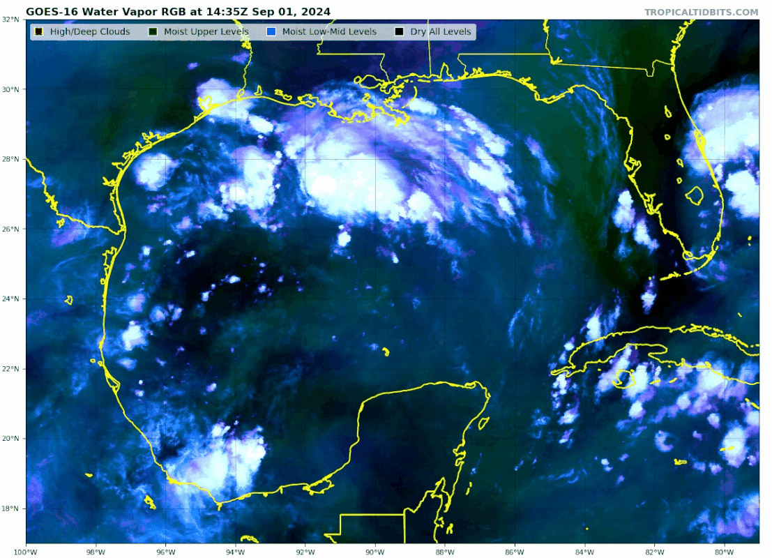
The new king of the NW Gulf/Phase 4? It remains to be seen. It showed the spin last Saturday for today and there is one albeit not as pronounced. It lingers the spin and drives it down to the bay of Campeche instead of lifting it out. Whether it’s right or not being able to reconcile possible 2 storms we have to see. CMC lifts it out. GFS is now picking it up but looks to merge the almost islands wave and comes back up to SE Texas a little stronger but not anything crazy. Most of the MJO models have us in phases 4 and 5 the next several days. Some go back into the circle. So it’s more of a watch and see scenario. I didn’t think it was going to be anything strong and ICON did have most of the rain offshore.
2 likes   

User avatar
cycloneye
Admin
Admin
Posts: 143863
Age: 68
Joined: Thu Oct 10, 2002 10:54 am
Location: San Juan, Puerto Rico

Re: Area of disturbed weather in NW Gulf of Mexico (10/10)

#82 Postby cycloneye » Sun Sep 01, 2024 12:40 pm

Northwestern Gulf of Mexico:
A broad area of low pressure just offshore of the upper Texas coast
continues to produce some disorganized shower and thunderstorm
activity near the coasts of Texas and Louisiana and over the
adjacent waters of the northwestern Gulf. This system is expected to
meander near the coast for the next couple of days, and some slow
development is possible if it remains offshore. By Tuesday, the
system is forecast to move inland, and further development is not
expected. Regardless, heavy rains could cause some flash flooding
across portions of coastal Louisiana and the upper Texas coast
during the next couple of days.
* Formation chance through 48 hours...low...10 percent.
* Formation chance through 7 days...low...10 percent.
0 likes   
Visit the Caribbean-Central America Weather Thread where you can find at first post web cams,radars
and observations from Caribbean basin members Click Here

Frank P
S2K Supporter
S2K Supporter
Posts: 2772
Joined: Fri Aug 29, 2003 10:52 am
Location: Biloxi Beach, Ms
Contact:

Re: Area of disturbed weather in NW Gulf of Mexico (10/20)

#83 Postby Frank P » Sun Sep 01, 2024 12:46 pm

Watching, just checked the buoys in the GOM and no falling pressure right from the platforms or ships report, most are either steady with some rising. Not much is going to happen until the pressure start dropping.
Lowest pressure appears to be on the Corpus Christi TX coast 29.85 and Buoy 42002 about 200 miles east of Brownville 29.85mb
Wind Direction (WDIR): W
Wind Speed Wind Speed (WSPD): 11.7 kts
Wind Gust Wind Gust (GST): 13.6 kts
Wind Speed at 10 Meters Wind Speed at 10 meters (WSPD10M): 11.7 kts
Wind Speed at 20 Meters Wind Speed at 20 meters (WSPD20M): 13.6 kts
1 likes   

User avatar
tropicwatch
Category 5
Category 5
Posts: 3364
Age: 61
Joined: Sat Jun 02, 2007 10:01 am
Location: Panama City Florida
Contact:

Re: Area of disturbed weather in NW Gulf of Mexico (10/10)

#84 Postby tropicwatch » Sun Sep 01, 2024 2:06 pm

Pressures are beginning to fall.
0 likes   
Tropicwatch


Agnes 72', Eloise 75, Elena 85', Kate 85', Charley 86', Florence 88', Beryl 94', Dean 95', Erin 95', Opal 95', Earl 98', Georges 98', Ivan 2004', Arlene 2005', Dennis 2005', Ida 2009' Debby 2012' Irma 2017' Michael 2018'

Frank P
S2K Supporter
S2K Supporter
Posts: 2772
Joined: Fri Aug 29, 2003 10:52 am
Location: Biloxi Beach, Ms
Contact:

Re: Area of disturbed weather in NW Gulf of Mexico (10/10)

#85 Postby Frank P » Sun Sep 01, 2024 2:32 pm

tropicwatch wrote:Pressures are beginning to fall.

Yes indeed they are now.. lowest I could find out in the GOM was Buoy 42002 @29.83mb and several near the CC TX area at 29.83, and a 29.82mb from a ship report off the coast of TX near CC. The little LLC off the Tx coast is pretty weak and far removed from any convection, unless another LLC develops near the convection in the central GOM or some convection starts to develop around that weak LLC off the TX coast not much is going to happen with this system.
1 likes   

User avatar
tropicwatch
Category 5
Category 5
Posts: 3364
Age: 61
Joined: Sat Jun 02, 2007 10:01 am
Location: Panama City Florida
Contact:

Re: Area of disturbed weather in NW Gulf of Mexico (10/10)

#86 Postby tropicwatch » Sun Sep 01, 2024 2:41 pm

Frank P wrote:
tropicwatch wrote:Pressures are beginning to fall.

Yes indeed they are now.. lowest I could find out in the GOM was Buoy 42002 @29.83mb and several near the CC TX area at 29.83, and a 29.82mb from a ship report off the coast of TX near CC. The little LLC off the Tx coast is pretty weak and far removed from any convection, unless another LLC develops near the convection in the central GOM or some convection starts to develop around that weak LLC off the TX coast not much is going to happen with this system.


The 10m wind field rotation appears to be closer to Buoy 42002 then the Texas coast.
1 likes   
Tropicwatch


Agnes 72', Eloise 75, Elena 85', Kate 85', Charley 86', Florence 88', Beryl 94', Dean 95', Erin 95', Opal 95', Earl 98', Georges 98', Ivan 2004', Arlene 2005', Dennis 2005', Ida 2009' Debby 2012' Irma 2017' Michael 2018'

User avatar
REDHurricane
Category 1
Category 1
Posts: 394
Age: 27
Joined: Sun Jul 03, 2022 2:36 pm
Location: Northeast Pacific Ocean

Re: Area of disturbed weather in NW Gulf of Mexico (10/10)

#87 Postby REDHurricane » Sun Sep 01, 2024 3:11 pm

Rotation appears to be slowly shifting towards the bulk of the convection south of Louisiana:

https://tropic.ssec.wisc.edu/real-time/ ... anim=html5
2 likes   

Horn1991
Tropical Low
Tropical Low
Posts: 40
Joined: Mon Jul 20, 2020 8:54 am
Location: The Woodlands, Texas

Re: Area of disturbed weather in NW Gulf of Mexico (10/10)

#88 Postby Horn1991 » Sun Sep 01, 2024 3:16 pm

REDHurricane wrote:Rotation appears to be slowly shifting towards the bulk of the convection south of Louisiana:

https://tropic.ssec.wisc.edu/real-time/ ... anim=html5


Yep
0 likes   

User avatar
Teban54
Category 5
Category 5
Posts: 3168
Joined: Sat May 19, 2018 1:19 pm

Re: Area of disturbed weather in NW Gulf of Mexico (10/10)

#89 Postby Teban54 » Sun Sep 01, 2024 3:22 pm

Dry air won't be an inhibiting factor, unlike earlier in the season when Debby was here.

Image
0 likes   

User avatar
Hammy
Category 5
Category 5
Posts: 5849
Age: 41
Joined: Fri May 25, 2012 5:25 pm
Contact:

Re: Area of disturbed weather in NW Gulf of Mexico (10/10)

#90 Postby Hammy » Sun Sep 01, 2024 3:27 pm

There's still way too much shear (an issue we've seen in the Gulf for weeks now)

The NAM isn't even showing development, and until it does this is DOA
0 likes   
The above post is not official and should not be used as such. It is the opinion of the poster and may or may not be backed by sound meteorological data. It is not endorsed by any professional institution or storm2k.org. For official information, please refer to the NHC and NWS products.

Frank P
S2K Supporter
S2K Supporter
Posts: 2772
Joined: Fri Aug 29, 2003 10:52 am
Location: Biloxi Beach, Ms
Contact:

Re: Area of disturbed weather in NW Gulf of Mexico (10/10)

#91 Postby Frank P » Sun Sep 01, 2024 3:28 pm

The IR sat loops looks more impressive than the vis sat loop, the entire system hints of perhaps a southward drift? But the bulk of the deepest convection is on the south side of the system in the central GOM att. I think 10% is reasonable.
0 likes   

Stratton23
Category 5
Category 5
Posts: 2370
Joined: Fri Jul 21, 2023 10:59 pm
Location: Katy, Tx

Re: Area of disturbed weather in NW Gulf of Mexico (10/10)

#92 Postby Stratton23 » Sun Sep 01, 2024 3:29 pm

Hammy the NAM is utter garbage with tropical development, its really only useful for winter, temperature and that sort of stuff
1 likes   

TomballEd
Category 2
Category 2
Posts: 579
Age: 61
Joined: Wed Aug 16, 2023 4:52 pm
Location: Spring/Klein area, not Tomball

Re: Area of disturbed weather in NW Gulf of Mexico (10/10)

#93 Postby TomballEd » Sun Sep 01, 2024 3:34 pm

I think this has a better chance of becoming a named storm than the AOI approaching the Caribbean. Limited space to work with, but visible satellite showing spin/vorticity, CIMSS analysis sees it, MIMIC-TPW starting to get that first hint of an interesting look as the 40% mandarin looks less organized on satellite and TPC loops, shear isn't horrible. Ensemble members that do support this not showing much below 1010 mb lows, but as is is much closer to home, now of greater interest that the system soon to enter the Caribbean.

Image Image
1 likes   

TomballEd
Category 2
Category 2
Posts: 579
Age: 61
Joined: Wed Aug 16, 2023 4:52 pm
Location: Spring/Klein area, not Tomball

Re: Area of disturbed weather in NW Gulf of Mexico (10/10)

#94 Postby TomballEd » Sun Sep 01, 2024 3:37 pm

Hammy wrote:There's still way too much shear (an issue we've seen in the Gulf for weeks now)

The NAM isn't even showing development, and until it does this is DOA


The shear goes from very hostile to fairly favorable in a tight gradient, this may get far enough S of the strong winds that they promote divergence and outflow aloft, while the center develops until much less severe shear. I'm not saying odds are high, but between odds of development and proximity to the USA, I'm now paying more attention to this.
0 likes   

User avatar
Teban54
Category 5
Category 5
Posts: 3168
Joined: Sat May 19, 2018 1:19 pm

Re: Area of disturbed weather in NW Gulf of Mexico (10/10)

#95 Postby Teban54 » Sun Sep 01, 2024 3:40 pm

Frank P wrote:The IR sat loops looks more impressive than the vis sat loop, the entire system hints of perhaps a southward drift? But the bulk of the deepest convection is on the south side of the system in the central GOM att. I think 10% is reasonable.

The impression of a "southward drift" could also just be a result of shear pushing the convection to the south, though.
1 likes   

User avatar
Hammy
Category 5
Category 5
Posts: 5849
Age: 41
Joined: Fri May 25, 2012 5:25 pm
Contact:

Re: Area of disturbed weather in NW Gulf of Mexico (10/10)

#96 Postby Hammy » Sun Sep 01, 2024 3:41 pm

Stratton23 wrote:Hammy the NAM is utter garbage with tropical development, its really only useful for winter, temperature and that sort of stuff


This is very true, when we're talking the track, because it overdevelops storms--but it's extremely useful in knowing when something is (or rather, isn't) going to develop.

I've used and familiarized myself with it for over a decade now, and it's ALWAYS, without fail, picked up these close to home storms well before any of the models do--it has spun up things that don't form, but not once has it actually missed a storm--if something's going to form in the Gulf, it's always the first to show it.

Given how hypersensitive this model is, if even it isn't showing development, then there isn't likely going to be any, the same way the UKMET is a near-certainty when it actually does show development (given it has the opposite issue of frequently missing storms)
Last edited by Hammy on Sun Sep 01, 2024 3:45 pm, edited 1 time in total.
2 likes   
The above post is not official and should not be used as such. It is the opinion of the poster and may or may not be backed by sound meteorological data. It is not endorsed by any professional institution or storm2k.org. For official information, please refer to the NHC and NWS products.

Frank P
S2K Supporter
S2K Supporter
Posts: 2772
Joined: Fri Aug 29, 2003 10:52 am
Location: Biloxi Beach, Ms
Contact:

Re: Area of disturbed weather in NW Gulf of Mexico (10/10)

#97 Postby Frank P » Sun Sep 01, 2024 3:44 pm

Add this to the equation as well, the vort in the central GOM is stronger than the AOI in the Atlantic
Image
0 likes   

Frank P
S2K Supporter
S2K Supporter
Posts: 2772
Joined: Fri Aug 29, 2003 10:52 am
Location: Biloxi Beach, Ms
Contact:

Re: Area of disturbed weather in NW Gulf of Mexico (10/10)

#98 Postby Frank P » Sun Sep 01, 2024 3:48 pm

Teban54 wrote:
Frank P wrote:The IR sat loops looks more impressive than the vis sat loop, the entire system hints of perhaps a southward drift? But the bulk of the deepest convection is on the south side of the system in the central GOM att. I think 10% is reasonable.

The impression of a "southward drift" could also just be a result of shear pushing the convection to the south, though.

Yeah I thought that too but the vort is just about near the center of the GOM… which surprises me as no model even came close to picking that up at that location, but point taken.
0 likes   

User avatar
Ubuntwo
Category 5
Category 5
Posts: 1401
Age: 31
Joined: Thu Oct 05, 2017 10:41 pm

Re: Area of disturbed weather in NW Gulf of Mexico (10/10)

#99 Postby Ubuntwo » Sun Sep 01, 2024 3:51 pm

Frank P wrote:
Teban54 wrote:
Frank P wrote:The IR sat loops looks more impressive than the vis sat loop, the entire system hints of perhaps a southward drift? But the bulk of the deepest convection is on the south side of the system in the central GOM att. I think 10% is reasonable.

The impression of a "southward drift" could also just be a result of shear pushing the convection to the south, though.

Yeah I thought that too but the vort is just about near the center of the GOM… which surprises me as no model even came close to picking that up at that location, but point taken.

That is the 500 mb vorticity, best colocated with the deep convection. The low level swirl near the Texas coast comes up at 850 mb:
Image

Notice the heavy tilt with height, that's the main reason this system is not developing right now.
0 likes   
Kendall -> SLO -> PBC

Memorable Storms: Katrina (for its Florida landfall...) Wilma Matthew Irma

User avatar
Teban54
Category 5
Category 5
Posts: 3168
Joined: Sat May 19, 2018 1:19 pm

Re: Area of disturbed weather in NW Gulf of Mexico (10/10)

#100 Postby Teban54 » Sun Sep 01, 2024 3:54 pm

Here's the 3km NAM run for clarification purposes. Its current depictions are:

  • The convection we're seeing right now dies in a couple hours. This may imply they're partially shear-induced, even though associated with a mid-level vortex (as Frank mentioned above).
  • The current low-level vort just offshore Texas drifts SW towards Corpus Christi during the next 36 hours or so.
  • However, during the same time frame, the mid-level vort that's currently in central Gulf also gets better defined on its own, while remaining largely stationary. Another low-level vort shows up underneath it in the next 10 hours, but gets pushed to the W much faster than mid-level.
  • Beyond 36 hrs, the COC that's now a bit west of Corpus Christi does try to develop a mid-level rotation, but it's too late as the system is already inland.

Image
1 likes   


Return to “Talkin' Tropics”

Who is online

Users browsing this forum: No registered users and 94 guests