Tropical Wave in Bay of Campeche (Is Invest 91L)

This is the general tropical discussion area. Anyone can take their shot at predicting a storms path.

Moderator: S2k Moderators

Forum rules

The posts in this forum are NOT official forecasts and should not be used as such. They are just the opinion of the poster and may or may not be backed by sound meteorological data. They are NOT endorsed by any professional institution or STORM2K. For official information, please refer to products from the National Hurricane Center and National Weather Service.

Help Support Storm2K
Message
Author
User avatar
Ubuntwo
Category 5
Category 5
Posts: 1401
Age: 31
Joined: Thu Oct 05, 2017 10:41 pm

Re: Tropical Wave east of Lesser Antilles (10/40)

#781 Postby Ubuntwo » Sun Sep 01, 2024 3:30 pm

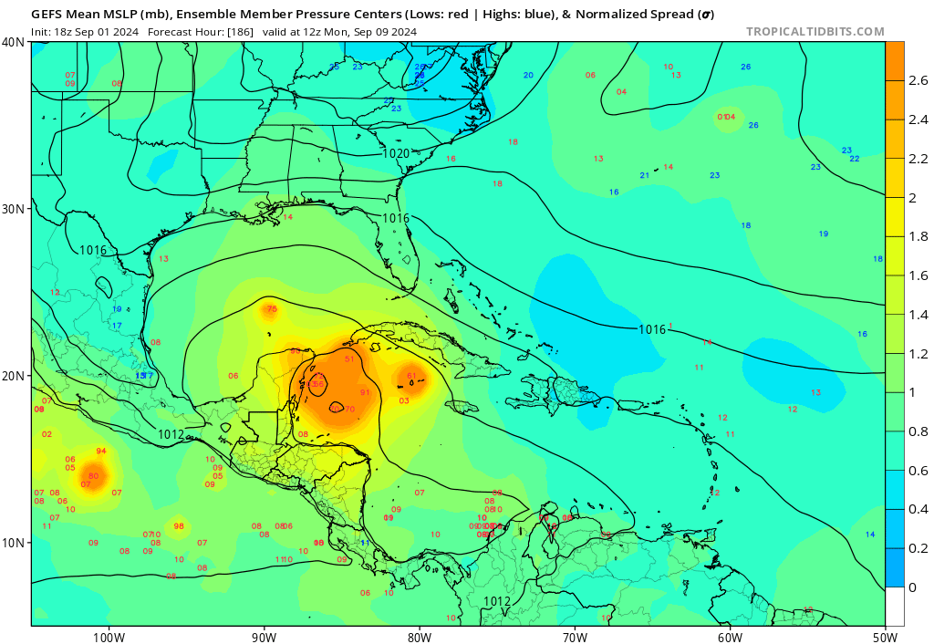
TomballEd wrote:A whole lot less than 40% of the EPS have a system in the Gulf/BoC unless one wants to count the 10-20 knot and 20-30 knot 1006 and 1009 mb members as being TCs in the Gulf. The NW Gulf lemon, IMHO, has better odds of becoming a named system, and I'm not being bullish on the NW Gulf lemon.

I am only counting closed lows 1005 mb and below. Many of these are developing beyond day 10 due to a complex trough interaction (somewhat akin to the 12z GFS just without the Caribbean development). It's actually possible that this wave merges with vorticity from that Gulf system and develops as indicated by some ensemble members.
1 likes   
Kendall -> SLO -> PBC

Memorable Storms: Katrina (for its Florida landfall...) Wilma Matthew Irma

User avatar
Ubuntwo
Category 5
Category 5
Posts: 1401
Age: 31
Joined: Thu Oct 05, 2017 10:41 pm

Re: Tropical Wave east of Lesser Antilles (10/40)

#782 Postby Ubuntwo » Sun Sep 01, 2024 3:35 pm

Almost no mid level reflection with this wave @ 18z. Pretty dramatic swing from just yesterday.
Image
2 likes   
Kendall -> SLO -> PBC

Memorable Storms: Katrina (for its Florida landfall...) Wilma Matthew Irma

User avatar
Hammy
Category 5
Category 5
Posts: 5849
Age: 41
Joined: Fri May 25, 2012 5:25 pm
Contact:

Re: Tropical Wave east of Lesser Antilles (10/40)

#783 Postby Hammy » Sun Sep 01, 2024 3:50 pm

I honestly don't think I've ever seen this unfavorable of a low-level environment. I was certain even up to a day or two ago that we'd at least have a PTC by today.

We're really flying blind when even the CFS is failing to accurately see the environment beyond a few days
3 likes   
The above post is not official and should not be used as such. It is the opinion of the poster and may or may not be backed by sound meteorological data. It is not endorsed by any professional institution or storm2k.org. For official information, please refer to the NHC and NWS products.

User avatar
gatorcane
S2K Supporter
S2K Supporter
Posts: 23689
Age: 47
Joined: Sun Mar 13, 2005 3:54 pm
Location: Boca Raton, FL

Re: Tropical Wave east of Lesser Antilles (10/40)

#784 Postby gatorcane » Sun Sep 01, 2024 4:16 pm

To me it looks like this wave is getting heavily sheared (at least the northern part of the wave) with strong upper-level westerly winds with the high clouds getting blown off to the east. I don't think these hostile conditions were expected in this part of the basin at this point in the season. Active seasons like 2004 and 2005 saw multiple systems flourish in this area:

Image
1 likes   

User avatar
Teban54
Category 5
Category 5
Posts: 3168
Joined: Sat May 19, 2018 1:19 pm

Re: Tropical Wave east of Lesser Antilles (10/40)

#785 Postby Teban54 » Sun Sep 01, 2024 4:40 pm

Ironically, this is the most convectively active that I've seen from this wave in the past 48 hours :lol:

Image
0 likes   

User avatar
Nimbus
Category 5
Category 5
Posts: 5274
Joined: Mon Jul 19, 2004 10:54 am

Re: Tropical Wave east of Lesser Antilles (10/40)

#786 Postby Nimbus » Sun Sep 01, 2024 4:43 pm

gatorcane wrote:To me it looks like this wave is getting heavily sheared (at least the northern part of the wave) with strong upper-level westerly winds with the high clouds getting blown off to the east. I don't think these hostile conditions were expected in this part of the basin at this point in the season. Active seasons like 2004 and 2005 saw multiple systems flourish in this area:

https://i.postimg.cc/cLnLY1dL/goes16-vis-swir-catl.gif


Its the shear coming off south America you can see the high cirrus clouds blowing NE off the coastline.
GFS forecast this yesterday showing a 1011 mb closed low near -51w blown out into an open wave then closing off again south of Puerto Rico as a 1009 mb low. That is good for the island forecast and we can wait for WXman57 to get back from vacation to call Bones or not.
0 likes   

caneman
Category 5
Category 5
Posts: 1446
Joined: Fri Sep 05, 2014 5:44 am
Location: Clearwater Beach, Fl

Re: Tropical Wave east of Lesser Antilles (10/40)

#787 Postby caneman » Sun Sep 01, 2024 4:57 pm

After months of drought, parts of Florida are seeing record rainfall in the past couple of months. Some of these storms have been violent and like a tropical storm. So, mother nature has found a way to still release some of that energy on us. Seems somehow related to whatever this pattern is. It's not a pattern recall after 45 years of livng here
2 likes   

otowntiger
Category 5
Category 5
Posts: 1921
Joined: Tue Aug 31, 2004 7:06 pm

Re: Tropical Wave east of Lesser Antilles (10/40)

#788 Postby otowntiger » Sun Sep 01, 2024 5:16 pm

caneman wrote:After months of drought, parts of Florida are seeing record rainfall in the past couple of months. Some of these storms have been violent and like a tropical storm. So, mother nature has found a way to still release some of that energy on us. Seems somehow related to whatever this pattern is.

As I was driving thru a torrential downpour, vivid lightning hard gusty winds and streets turned into rivers block after block and nearly 6 inches of rain collected in less than 2 hours during a ‘regular’ afternoon thunderstorm here in Orlando, I was thinking the same thing! The energy will get dissipated one way or the other, if not by hurricanes. At least that’s my non-scientific/non-meteorologist theory.
1 likes   

User avatar
SFLcane
S2K Supporter
S2K Supporter
Posts: 10162
Age: 47
Joined: Sat Jun 05, 2010 1:44 pm
Location: Lake Worth Florida

Re: Tropical Wave east of Lesser Antilles (10/40)

#789 Postby SFLcane » Sun Sep 01, 2024 5:34 pm

gatorcane wrote:To me it looks like this wave is getting heavily sheared (at least the northern part of the wave) with strong upper-level westerly winds with the high clouds getting blown off to the east. I don't think these hostile conditions were expected in this part of the basin at this point in the season. Active seasons like 2004 and 2005 saw multiple systems flourish in this area:

https://i.postimg.cc/cLnLY1dL/goes16-vis-swir-catl.gif


Your comparing once in a lifetime anomalies likely never to be duplicated are these seasonal forecasts potentially busting sure though I urge there is still 90 days to go this hurricane season heavily backloaded surely on the table. For those living in a hurricane prone areas for me all that matters is “ impacts “ just takes 1 over your head I will leave the seasonal numbers and predictions to the forecasters.
1 likes   

User avatar
Teban54
Category 5
Category 5
Posts: 3168
Joined: Sat May 19, 2018 1:19 pm

Re: Tropical Wave east of Lesser Antilles (10/40)

#790 Postby Teban54 » Sun Sep 01, 2024 5:47 pm

Did people just stop watching models the moment they don't seem to suggest a CONUS threat?

Anyway, 18z GFS largely follows 12z's evolution with development in Western Caribbean and landfall in Belize, but slightly stronger (993 mb peak vs. 12z's 999). Ridging looks even stronger on this run, so the storm itself doesn't even seem to enter BoC and just crosses over to EPAC instead. However, at 240 hrs, it looks like a piece of the energy is now in BoC and may develop later this run, similar to 12z. (Edit: And it did.)

Such a scenario isn't unprecedented -- see Julia and Karl 2022.
Last edited by Teban54 on Sun Sep 01, 2024 6:11 pm, edited 1 time in total.
1 likes   

User avatar
Hammy
Category 5
Category 5
Posts: 5849
Age: 41
Joined: Fri May 25, 2012 5:25 pm
Contact:

Re: Tropical Wave east of Lesser Antilles (10/40)

#791 Postby Hammy » Sun Sep 01, 2024 6:00 pm

Teban54 wrote:Did people just stop watching models the moment they don't seem to suggest a CONUS threat?

Anyway, 18z GFS largely follows 12z's evolution with development in Western Caribbean and landfall in Belize, but slightly stronger (993 mb peak vs. 12z's 999). Ridging looks even stronger on this run, so the storm itself doesn't even seem to enter BoC and just crosses over to EPAC instead. However, at 240 hrs, it looks like a piece of the energy is now in BoC and may develop later this run, similar to 12z.

Such a scenario isn't unprecedented -- see Julia and Karl 2022.


Most people 'gave up watching' when the models once again showed an uptick in activity only to drop just about everything and show barely any development with the rest. If the models tick up again we'll see more people posting, but we're edging closer to 'may not develop at all' territory
3 likes   
The above post is not official and should not be used as such. It is the opinion of the poster and may or may not be backed by sound meteorological data. It is not endorsed by any professional institution or storm2k.org. For official information, please refer to the NHC and NWS products.

User avatar
ThunderForce
Tropical Storm
Tropical Storm
Posts: 208
Age: 25
Joined: Tue Sep 27, 2022 6:20 pm
Location: Calhoun County, Florida

Re: Tropical Wave east of Lesser Antilles (10/40)

#792 Postby ThunderForce » Sun Sep 01, 2024 6:08 pm

Sigh...
Image
3 likes   
Please refer to the NWS, NHC, SPC or a professional meteorologist for information and decision making during storms.

User avatar
WaveBreaking
Category 2
Category 2
Posts: 562
Joined: Sun Jun 30, 2024 11:33 am
Location: US

Re: Tropical Wave east of Lesser Antilles (10/40)

#793 Postby WaveBreaking » Sun Sep 01, 2024 6:20 pm


i cant with these models man i give up
2 likes   
I am NOT a professional meteorologist, so take all of my posts with a grain of salt. My opinions are mine and mine alone.

User avatar
aspen
Category 5
Category 5
Posts: 8812
Joined: Sat Oct 12, 2019 7:10 pm
Location: Connecticut, USA

Re: Tropical Wave east of Lesser Antilles (10/40)

#794 Postby aspen » Sun Sep 01, 2024 6:22 pm

Hammy wrote:
Teban54 wrote:Did people just stop watching models the moment they don't seem to suggest a CONUS threat?

Anyway, 18z GFS largely follows 12z's evolution with development in Western Caribbean and landfall in Belize, but slightly stronger (993 mb peak vs. 12z's 999). Ridging looks even stronger on this run, so the storm itself doesn't even seem to enter BoC and just crosses over to EPAC instead. However, at 240 hrs, it looks like a piece of the energy is now in BoC and may develop later this run, similar to 12z.

Such a scenario isn't unprecedented -- see Julia and Karl 2022.


Most people 'gave up watching' when the models once again showed an uptick in activity only to drop just about everything and show barely any development with the rest. If the models tick up again we'll see more people posting, but we're edging closer to 'may not develop at all' territory

This’ll probably end up as the longest pre-invest thread for an AOI that never develops.
6 likes   
Irene '11 Sandy '12 Hermine '16 5/15/2018 Derecho Fay '20 Isaias '20 Elsa '21 Henri '21 Ida '21

I am only a meteorology enthusiast who knows a decent amount about tropical cyclones. Look to the professional mets, the NHC, or your local weather office for the best information.

User avatar
cajungal
Category 5
Category 5
Posts: 2327
Age: 48
Joined: Sun Mar 14, 2004 9:34 pm
Location: Schriever, Louisiana (60 miles southwest of New Orleans)

Re: Tropical Wave east of Lesser Antilles (10/40)

#795 Postby cajungal » Sun Sep 01, 2024 6:25 pm

People are only interested if this posed a threat to the gulf coast. Since models majorly backed off and this may never develop, the posts died off. . I feel we been talking about this wave forever.
3 likes   

User avatar
ThunderForce
Tropical Storm
Tropical Storm
Posts: 208
Age: 25
Joined: Tue Sep 27, 2022 6:20 pm
Location: Calhoun County, Florida

Re: Tropical Wave east of Lesser Antilles (10/40)

#796 Postby ThunderForce » Sun Sep 01, 2024 6:28 pm

I wonder why the GEFS 18z ensemble is so different from the operational model?

Operational is similar to the last run but a bit south and somewhat stronger, but the ensemble is a complete 180.
Last edited by ThunderForce on Sun Sep 01, 2024 6:32 pm, edited 1 time in total.
0 likes   
Please refer to the NWS, NHC, SPC or a professional meteorologist for information and decision making during storms.

User avatar
AnnularCane
S2K Supporter
S2K Supporter
Posts: 2836
Joined: Thu Jun 08, 2006 9:18 am
Location: Wytheville, VA

Re: Tropical Wave east of Lesser Antilles (10/40)

#797 Postby AnnularCane » Sun Sep 01, 2024 6:28 pm

Interestingly the next invest number is the notorious 99L. Just saying. :double:
2 likes   
"But it never rained rain. It never snowed snow. And it never blew just wind. It rained things like soup and juice. It snowed mashed potatoes and green peas. And sometimes the wind blew in storms of hamburgers." -- Judi Barrett, Cloudy with a Chance of Meatballs

User avatar
cycloneye
Admin
Admin
Posts: 143867
Age: 68
Joined: Thu Oct 10, 2002 10:54 am
Location: San Juan, Puerto Rico

Re: Tropical Wave east of Lesser Antilles (10/40)

#798 Postby cycloneye » Sun Sep 01, 2024 6:31 pm

Near the Lesser Antilles and Caribbean Sea:
Disorganized shower and thunderstorm activity continues in
association with a tropical wave located a couple of hundred
miles east of the Lesser Antilles. The disturbance is expected to
move westward and reach the Lesser Antilles on Monday, then
cross the eastern Caribbean Sea on Tuesday. Environmental
conditions are forecast to become more conducive for development
while the system moves across the central and western Caribbean Sea
during the middle and latter parts of the week, and a tropical
depression could form during that time. Regardless of development,
this system could cause gusty winds and locally heavy rainfall over
portions of the Lesser Antilles tonight and Monday.
* Formation chance through 48 hours...low...10 percent.
* Formation chance through 7 days...medium...40 percent.
1 likes   
Visit the Caribbean-Central America Weather Thread where you can find at first post web cams,radars
and observations from Caribbean basin members Click Here

User avatar
Teban54
Category 5
Category 5
Posts: 3168
Joined: Sat May 19, 2018 1:19 pm

Re: Tropical Wave east of Lesser Antilles (10/40)

#799 Postby Teban54 » Sun Sep 01, 2024 6:33 pm

ThunderForce wrote:I'm really confused. Why is the GEFS 18z ensemble so different from the operational model?

Operational is similar to the last run but a bit south and somewhat stronger, but the ensemble is a complete 180.

This is probably one of the most head-scratching systems I ever tracked, from long term to short term, from models to the system's actual performance.
3 likes   

Frank P
S2K Supporter
S2K Supporter
Posts: 2772
Joined: Fri Aug 29, 2003 10:52 am
Location: Biloxi Beach, Ms
Contact:

Re: Tropical Wave east of Lesser Antilles (10/40)

#800 Postby Frank P » Sun Sep 01, 2024 6:38 pm

Apparently the NHC is more bullish than most of the folks here, myself included.
"Environmental conditions are forecast to become more conducive for development
while the system moves across the central and western Caribbean Sea
during the middle and latter parts of the week, and a tropical
depression could form during that time."
We get a TD in the west Caribbean Sea and it could be game on again, at least that is what my climatological brain cells are telling me... the two that work that is..
5 likes   


Return to “Talkin' Tropics”

Who is online

Users browsing this forum: Long John and 233 guests