2024 Global Model Runs Discussion (Out thru day 16)
Moderator: S2k Moderators
Forum rules

The posts in this forum are NOT official forecasts and should not be used as such. They are just the opinion of the poster and may or may not be backed by sound meteorological data. They are NOT endorsed by any professional institution or STORM2K. For official information, please refer to products from the National Hurricane Center and National Weather Service.
-
Weathertracker96
- Tropical Storm

- Posts: 150
- Joined: Mon Oct 16, 2023 3:41 pm
Re: 2024 Global Model Runs Discussion (Out thru day 16)
The 18z ICON seems to be showing some activity in the Atlantic. Whether it verifies is anyones guess.
0 likes

Re: 2024 Global Model Runs Discussion (Out thru day 16)
Weathertracker96 wrote:The 18z ICON seems to be showing some activity in the Atlantic. Whether it verifies is anyones guess.
Considering it tries to develop the wave that's currently SW of Cabo Verde, which the NHC has dropped and no other models are still doing, it sounds suspicious. On the other hand, the wave behind it that's the current 0/20 AOI does have some support from other models.
0 likes
TC naming lists: retirements and intensity
Most aggressive Advisory #1's in North Atlantic (cr. kevin for starting the list)
Most aggressive Advisory #1's in North Atlantic (cr. kevin for starting the list)
-
Blown Away

- S2K Supporter

- Posts: 10253
- Joined: Wed May 26, 2004 6:17 am
Re: 2024 Global Model Runs Discussion (Out thru day 16)
Labor Day during a hyper active predicted season, this is what I call dead!
5 likes
Hurricane Eye Experience: David 79, Irene 99, Frances 04, Jeanne 04, Wilma 05… Hurricane Brush Experience: Andrew 92, Erin 95, Floyd 99, Matthew 16, Irma 17, Ian 22, Nicole 22…
Re: 2024 Global Model Runs Discussion (Out thru day 16)
Blown Away wrote:[url]https://i.postimg.cc/0jMJ1dQ8/IMG-0044.jpg [/url]
Labor Day during a hyper active predicted season, this is what I call dead!
i still think there will be at least one more impactful hurricane this season before it's all said and done........hopefully i'm wrong!
0 likes
Re: 2024 Global Model Runs Discussion (Out thru day 16)
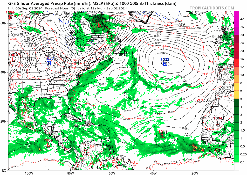
Somehow, 1.5 days after NHC wrote off the wave at 36W (not the healthy-looking 0/30 wave just offshore Africa), it's making a little bit of a comeback on the models... Albeit just a little bit.
0z ICON develops both the 36W wave and the 0/30 wave, but it somehow gets 3 TCs out of them, so it may be just typical ICON stuff. 0z CMC tries to spin up two things: The 0/30 (expected); and what looks like either the 36W wave or yet another monsoon trough breakdown, which then moves east. But they're too close and thus do not stay coherent, especially the latter.
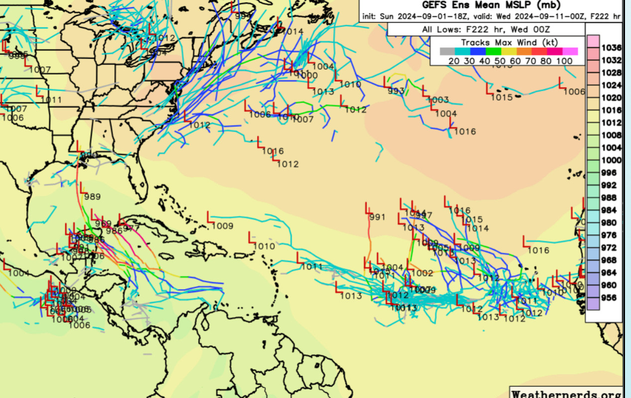
0z GFS, on the other hand, has the 36W wave moving west while having the strongest low-level vort of any run, with a 1007 mb low. This is also reflected on 0z GEFS with greatly increased support for this wave: roughly 10 members show 30+ kt winds (so probably not just a surface low), and about 7 members have a hurricane. 3 members have a strong hurricane just east of the Bahamas. Obviously this is very weak support, but consider that earlier GEFS runs had dropped to zero support for this 36W wave.
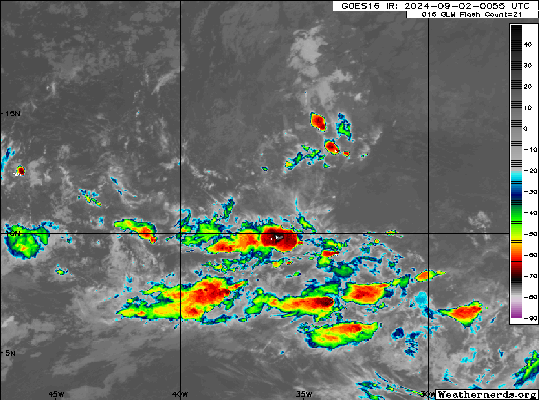
FWIW, there was a recent convective burst with this wave:
0z ICON develops both the 36W wave and the 0/30 wave, but it somehow gets 3 TCs out of them, so it may be just typical ICON stuff. 0z CMC tries to spin up two things: The 0/30 (expected); and what looks like either the 36W wave or yet another monsoon trough breakdown, which then moves east. But they're too close and thus do not stay coherent, especially the latter.
0z GFS, on the other hand, has the 36W wave moving west while having the strongest low-level vort of any run, with a 1007 mb low. This is also reflected on 0z GEFS with greatly increased support for this wave: roughly 10 members show 30+ kt winds (so probably not just a surface low), and about 7 members have a hurricane. 3 members have a strong hurricane just east of the Bahamas. Obviously this is very weak support, but consider that earlier GEFS runs had dropped to zero support for this 36W wave.
FWIW, there was a recent convective burst with this wave:
Last edited by Teban54 on Mon Sep 02, 2024 1:02 am, edited 1 time in total.
1 likes
TC naming lists: retirements and intensity
Most aggressive Advisory #1's in North Atlantic (cr. kevin for starting the list)
Most aggressive Advisory #1's in North Atlantic (cr. kevin for starting the list)
Re: 2024 Global Model Runs Discussion (Out thru day 16)
The eastern Atlantic looks like it's really finally kicking up some convection. Will it stick? This may be the start of an active Sept. We will see.
0 likes
-
Stormlover70
- Tropical Storm
- Posts: 194
- Age: 56
- Joined: Fri Jun 21, 2024 5:31 am
- Location: New port richey
Re: 2024 Global Model Runs Discussion (Out thru day 16)
Either that or a period of quiet years. We have had above average storm numbers for years. It's cycles that are key here. We haven't been on this earth long enough to predict as much as we think we can. Just my opinion.caneman wrote:The eastern Atlantic looks like it's really finally kicking up some convection. Will it stick? This may be the start of an active Sept. We will see.
1 likes
Re: 2024 Global Model Runs Discussion (Out thru day 16)
0 likes
TC naming lists: retirements and intensity
Most aggressive Advisory #1's in North Atlantic (cr. kevin for starting the list)
Most aggressive Advisory #1's in North Atlantic (cr. kevin for starting the list)
-
Stormlover70
- Tropical Storm
- Posts: 194
- Age: 56
- Joined: Fri Jun 21, 2024 5:31 am
- Location: New port richey
-
eastcoastFL

- Category 5

- Posts: 3996
- Age: 44
- Joined: Thu Apr 12, 2007 12:29 pm
- Location: Palm City, FL
Re: 2024 Global Model Runs Discussion (Out thru day 16)
GFS should've taken labor day off. That's insane.
2 likes
Personal Forecast Disclaimer:
The posts in this forum are NOT official forecast and should not be used as such. They are just the opinion of the poster and may or may not be backed by sound meteorological data. They are NOT endorsed by any professional institution or storm2k.org. For official information, please refer to the NHC and NWS products.
The posts in this forum are NOT official forecast and should not be used as such. They are just the opinion of the poster and may or may not be backed by sound meteorological data. They are NOT endorsed by any professional institution or storm2k.org. For official information, please refer to the NHC and NWS products.
-
Hurricaneman

- Category 5
- Posts: 7404
- Age: 45
- Joined: Tue Aug 31, 2004 3:24 pm
- Location: central florida
Re: 2024 Global Model Runs Discussion (Out thru day 16)
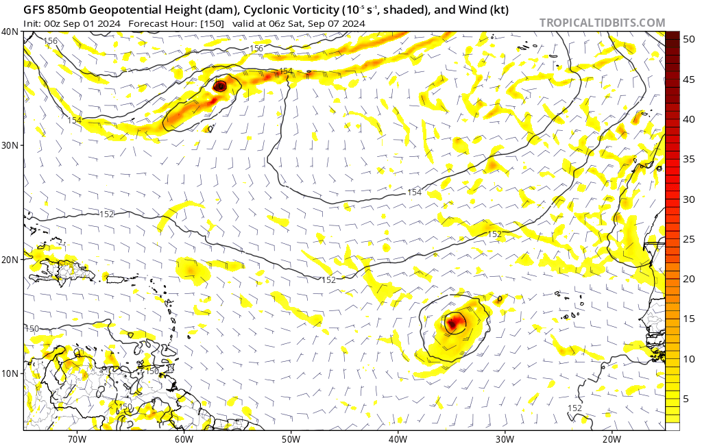
My thoughts on the last couple of GFS runs, the GFS tries but fails to develop the wave at 36W but don’t shy away from it because I think this feature will over perform and I think the GOM to east coast system is a phantom feedback from the front to the BOC aka the 0/40 Caribbean system so it’s possible we have 3 named storms by sometime next week which means the bell is finally ringing but 3 weeks late
0 likes
-
gatorcane

- S2K Supporter
- Posts: 23708
- Age: 48
- Joined: Sun Mar 13, 2005 3:54 pm
- Location: Boca Raton, FL
Re: 2024 Global Model Runs Discussion (Out thru day 16)
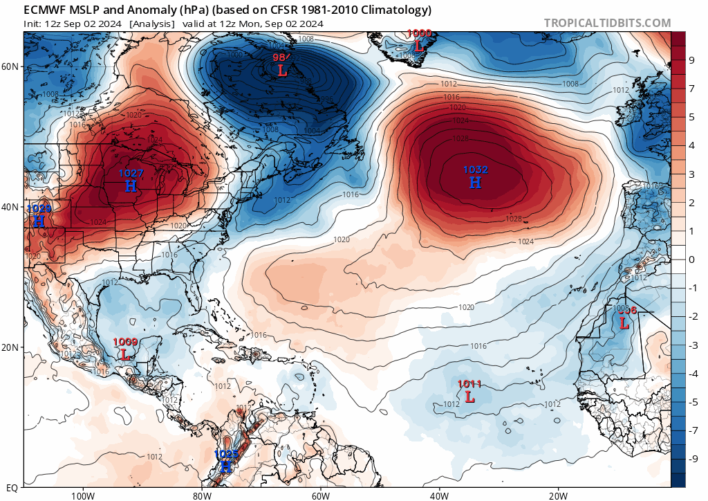
Atlantic Cape Verde activity might be showing some signs of life, but fortunately the GFS has a massive trough over the Eastern Atlantic where normally there would be an Azores High, which does not allow these waves to move west, even being weak. They also get "tangled" up in each other:

2 likes
Re: 2024 Global Model Runs Discussion (Out thru day 16)
gatorcane wrote:Atlantic Cape Verde activity might be showing some signs of life, but fortunately the GFS has a massive trough over the Eastern Atlantic where normally there would be an Azores High, which does not allow these waves to move west, even being weak. They also get "tangled" up in each other:
https://i.postimg.cc/cHZr4Hqk/gfs-z500a-Norm-atl-fh90-210.gif
good news for the islands and east coast of the U.S.
1 likes
Re: 2024 Global Model Runs Discussion (Out thru day 16)
The past 3 full-length Euro runs show a TC forming immediately after exiting Africa. On this particular 12z run, it shows some signs of recurving, but Euro has been very inconsistent at showing extratropical patterns 10 days out in the past few runs. If you replace it with some of the earlier solutions or 12z GFS, you'd get a storm moving due west as ridge builds back.
Track and intensity aren't really what matters here, though: It's that between these Euro runs and earlier GFS stuff that sometimes show several storms from the ITCZ, models are starting to show something (other than the two oranges right now), even if in the long range. As a reminder, 10 days ago operational models were consistently showing nothing would form in 384 hours. For people who thought they were accurately showing hostile conditions at that time, applying the same logic would mean they may be starting to sense more favorable conditions (for genesis at least).
Track and intensity aren't really what matters here, though: It's that between these Euro runs and earlier GFS stuff that sometimes show several storms from the ITCZ, models are starting to show something (other than the two oranges right now), even if in the long range. As a reminder, 10 days ago operational models were consistently showing nothing would form in 384 hours. For people who thought they were accurately showing hostile conditions at that time, applying the same logic would mean they may be starting to sense more favorable conditions (for genesis at least).
1 likes
TC naming lists: retirements and intensity
Most aggressive Advisory #1's in North Atlantic (cr. kevin for starting the list)
Most aggressive Advisory #1's in North Atlantic (cr. kevin for starting the list)

Re: 2024 Global Model Runs Discussion (Out thru day 16)
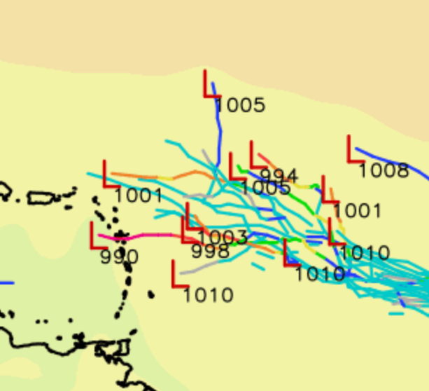
00z ICON has 4 or 5 active TCs in 7 days, including 3 tropical storms all in the eastern MDR (which tbh looks just as crazy as nothing forming over the next 7 days  ).
).

2 likes
-
REDHurricane

- Category 1

- Posts: 438
- Age: 28
- Joined: Sun Jul 03, 2022 2:36 pm
- Location: Northeast Pacific Ocean
Re: 2024 Global Model Runs Discussion (Out thru day 16)
I am completely discounting all models right now until they actually hit on something. Whatever weird stuff is happening this season is obviously not being picked up by the models in the slightest, so until that changes I don't see any reason to put any stock into anything they're predicting, development or not -- we might as well be back in the 1800s at this point

3 likes
-
jlauderdal
- S2K Supporter
- Posts: 7240
- Joined: Wed May 19, 2004 5:46 am
- Location: NE Fort Lauderdale
- Contact:
Re: 2024 Global Model Runs Discussion (Out thru day 16)
REDHurricane wrote:I am completely discounting all models right now until they actually hit on something. Whatever weird stuff is happening this season is obviously not being picked up by the models in the slightest, so until that changes I don't see any reason to put any stock into anything they're predicting, development or not -- we might as well be back in the 1800s at this point
Ensembles are doing us wrong, too, It's time to dumb it down and look at the real weather sats, radar, and obs, and when we see something, then we have something. Do we stop watching models, no...buyer beware, more than ever. Their will be writeups and tweets and analysis after this season, i doubt they come up with a consistent explanation as to the short, medium and climo models for this season.
0 likes
Re: 2024 Global Model Runs Discussion (Out thru day 16)
12Z UKMET has a strong TS form well off the US E coast Wed night that then moves NE and hits Nova Scotia this weekend:
NEW TROPICAL CYCLONE FORECAST TO DEVELOP AFTER 66 HOURS
FORECAST POSITION AT T+ 66 : 34.8N 70.6W
LEAD CENTRAL MAXIMUM WIND
VERIFYING TIME TIME POSITION PRESSURE (MB) SPEED (KNOTS)
-------------- ---- -------- ------------- -------------
1200UTC 06.09.2024 72 36.8N 68.9W 1010 34
0000UTC 07.09.2024 84 39.2N 66.8W 1005 45
1200UTC 07.09.2024 96 41.4N 64.9W 997 43
0000UTC 08.09.2024 108 44.0N 63.3W 998 39
1200UTC 08.09.2024 120 47.1N 62.3W 1003 32
0000UTC 09.09.2024 132 49.4N 60.9W 1007 25
1200UTC 09.09.2024 144 CEASED TRACKING
0 likes
Personal Forecast Disclaimer:
The posts in this forum are NOT official forecasts and should not be used as such. They are just the opinion of the poster and may or may not be backed by sound meteorological data. They are NOT endorsed by any professional institution or storm2k.org. For official information, please refer to the NHC and NWS products.
The posts in this forum are NOT official forecasts and should not be used as such. They are just the opinion of the poster and may or may not be backed by sound meteorological data. They are NOT endorsed by any professional institution or storm2k.org. For official information, please refer to the NHC and NWS products.
Re: 2024 Global Model Runs Discussion (Out thru day 16)
Happy Hour GFS never disappoints even in the darkest times
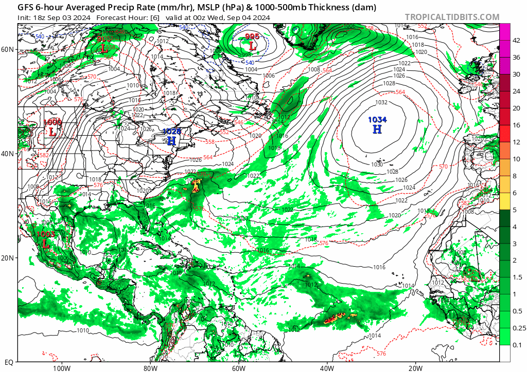
On a more serious note: The storm that 18z GFS blows up is technically neither of the two waves highlighted in the TWO, but a monsoon trough breakdown between them, possibly triggered by the persistent convection that's now near 10N 35W (which had been convectively active since Africa). GFS has been hinting at this for a while now, occasionally showing 3 systems forming in the open Atlantic, although they usually stay very weak and other recent runs had become more bearish.
The interesting thing is that 12z Euro also showed the monsoon trough breakdown, unlike all its earlier runs. The run ends with a TD/weak TS moving west after having meandered in the eastern MDR for days.
(Also note that Euro and its ensembles continue to show an Eastern Atlantic system around 9/10, though it quickly recurves near 35W and thus never gets a chance to become much stronger.)
0 likes
TC naming lists: retirements and intensity
Most aggressive Advisory #1's in North Atlantic (cr. kevin for starting the list)
Most aggressive Advisory #1's in North Atlantic (cr. kevin for starting the list)
Re: 2024 Global Model Runs Discussion (Out thru day 16)
Teban54 wrote:Happy Hour GFS never disappoints even in the darkest times
https://i.postimg.cc/BZggGk4N/gfs-mslp-pcpn-atl-fh6-384.gif
On a more serious note: The storm that 18z GFS blows up is technically neither of the two waves highlighted in the TWO, but a monsoon trough breakdown between them, possibly triggered by the persistent convection that's now near 10N 35W (which had been convectively active since Africa). GFS has been hinting at this for a while now, occasionally showing 3 systems forming in the open Atlantic, although they usually stay very weak and other recent runs had become more bearish.
The interesting thing is that 12z Euro also showed the monsoon trough breakdown, unlike all its earlier runs. The run ends with a TD/weak TS moving west after having meandered in the eastern MDR for days.
(Also note that Euro and its ensembles continue to show an Eastern Atlantic system around 9/10, though it quickly recurves near 35W and thus never gets a chance to become much stronger.)
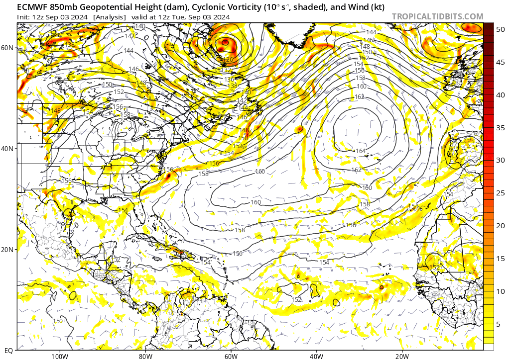
https://i.postimg.cc/0Ny6DWL5/ecmwf-z850-vort-atl-fh0-240.gif
Any chance that that strong sfc low forming well off the US E coast late this week on the 18Z GFS is either subtropical or tropical? The 12Z UKMET text as noted just above has this classified as a TC although I have my doubts and would think more likely ST vs T.
0 likes
Personal Forecast Disclaimer:
The posts in this forum are NOT official forecasts and should not be used as such. They are just the opinion of the poster and may or may not be backed by sound meteorological data. They are NOT endorsed by any professional institution or storm2k.org. For official information, please refer to the NHC and NWS products.
The posts in this forum are NOT official forecasts and should not be used as such. They are just the opinion of the poster and may or may not be backed by sound meteorological data. They are NOT endorsed by any professional institution or storm2k.org. For official information, please refer to the NHC and NWS products.
Who is online
Users browsing this forum: No registered users and 121 guests