Tropical Wave in Bay of Campeche (Is Invest 91L)
Moderator: S2k Moderators
Forum rules

The posts in this forum are NOT official forecasts and should not be used as such. They are just the opinion of the poster and may or may not be backed by sound meteorological data. They are NOT endorsed by any professional institution or STORM2K. For official information, please refer to products from the National Hurricane Center and National Weather Service.
-
Stratton23
- Category 5

- Posts: 3477
- Joined: Fri Jul 21, 2023 10:59 pm
- Location: Katy, Tx
Re: Tropical Wave in Eastern Caribbean (0/40)
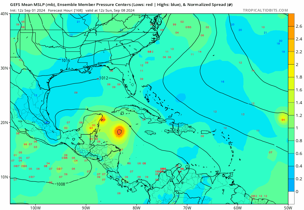
the GEFS 12z is already stronger through 90 hours in the western caribbean than the operational run, that can make a massive difference on a track
0 likes

Re: Tropical Wave in Eastern Caribbean (0/40)
We all know that tropical systems feed off of warm water, and diminish as the water gets cooler. Is it reasonably possible that the latent heat in the MDR is too high and the thermodynamic effects caused by this is misunderstood as it relates to cyclogenesis?
0 likes
-
Frank P
- S2K Supporter

- Posts: 2779
- Joined: Fri Aug 29, 2003 10:52 am
- Location: Biloxi Beach, Ms
- Contact:
Re: Tropical Wave in Eastern Caribbean (0/40)
I think perhaps this might be the most convection associated with this weak system to date and been slowly increasing all morning. not sure which one is uglier, the southern lobe or the northern lobe... but at least is not fizzled out yet... So yeah, there's still a chance. 

0 likes
-
Stratton23
- Category 5
- Posts: 3477
- Joined: Fri Jul 21, 2023 10:59 pm
- Location: Katy, Tx
Re: Tropical Wave in Eastern Caribbean (0/40)
Model support is increasing again, id probably increase odds back up to 50%, i think we are going to get Francine out of this one at some point
0 likes

Re: Tropical Wave in Eastern Caribbean (0/40)
I can't even.
1 likes
TC naming lists: retirements and intensity
Most aggressive Advisory #1's in North Atlantic (cr. kevin for starting the list)
Most aggressive Advisory #1's in North Atlantic (cr. kevin for starting the list)

Re: Tropical Wave in Eastern Caribbean (0/40)
It's an intriguing trend, especially considering a few still get this very strong. But it should be said developing members represent only 1/3 of the pack. That number was somewhat similar on the 6z EPS.
1 likes
Kendall -> SLO -> PBC
Memorable Storms: Katrina (for its Florida landfall...) Wilma Matthew Irma
Memorable Storms: Katrina (for its Florida landfall...) Wilma Matthew Irma


Re: Tropical Wave in Eastern Caribbean (0/40)
Afternoon NHC probs remain at 40% for said AOI.
0 likes
-
Stratton23
- Category 5
- Posts: 3477
- Joined: Fri Jul 21, 2023 10:59 pm
- Location: Katy, Tx
Re: Tropical Wave in Eastern Caribbean (0/40)
Euro doesnt bury it into CA, looks like the energy is able to slip into the BOC, and move more NNW on this run, weak broad low sitting off the central mexican coast at the end of its 12z run fwiw
0 likes
-
TomballEd
- Category 5
- Posts: 1242
- Age: 62
- Joined: Wed Aug 16, 2023 4:52 pm
- Location: Spring/Klein area, not Tomball
Re: Tropical Wave in Eastern Caribbean (0/40)
Unless something has changed, the GEFS run at half the resolution as the GFS. I believe, OTOH, the Euro ensembles run at the same resolution as the op. The lower resolution is why there is a control member, an ensemble run with the same initial conditions as the GFS. I recall from long ago when I was paying for AccuWx, or maybe WxBell, the control member at 10 days was often very, very different than the op, simply because of resolution. I'll admit the one ensemble with a major hurricane (942 mb just before landfall near Corpus Christi) is eye catching, but it is an outlier. The pale blue and blue members are predicting a TD or minimal TC. Enough to justify leaving 40% alone.
I like the Weathernerds better, not out to the outlier major hurricanes but easier to see.
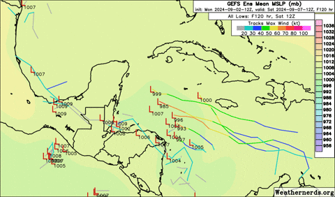
I like the Weathernerds better, not out to the outlier major hurricanes but easier to see.
0 likes
-
Stratton23
- Category 5
- Posts: 3477
- Joined: Fri Jul 21, 2023 10:59 pm
- Location: Katy, Tx
Re: Tropical Wave in Eastern Caribbean (0/40)
EPS upticked in the BOC, also looks like its combining our gulf low and the system into one, the members all kinda merge together, interesting
0 likes
-
hurricane2025
- Category 1

- Posts: 254
- Joined: Thu Apr 08, 2021 10:36 am
-
Stratton23
- Category 5
- Posts: 3477
- Joined: Fri Jul 21, 2023 10:59 pm
- Location: Katy, Tx
Re: Tropical Wave in Eastern Caribbean (0/40)
our tropical wave has a heartbeat today, despite being currently sheared, its looking a lot more healthy than it did yesterday, probably why model support has gone up a bit more today, either way this is looking more like a western gulf thing ( mexico- lousiana) than an eastern gulf, will be interesting to see if this uptrend continues
0 likes
-
Stratton23
- Category 5
- Posts: 3477
- Joined: Fri Jul 21, 2023 10:59 pm
- Location: Katy, Tx
Re: Tropical Wave in Eastern Caribbean (0/40)
our tropical wave has a heartbeat today, despite being currently sheared, its looking a lot more healthy than it did yesterday, probably why model support has gone up a bit more today, either way this is looking more like a western gulf thing ( mexico- lousiana) than an eastern gulf, will be interesting to see if this uptrend continues
2 likes
-
Frank P
- S2K Supporter
- Posts: 2779
- Joined: Fri Aug 29, 2003 10:52 am
- Location: Biloxi Beach, Ms
- Contact:
Re: Tropical Wave in Eastern Caribbean (0/40)
Stratton23 wrote:our tropical wave has a heartbeat today, despite being currently sheared, its looking a lot more healthy than it did yesterday, probably why model support has gone up a bit more today, either way this is looking more like a western gulf thing ( mexico- lousiana) than an eastern gulf, will be interesting to see if this uptrend continues
Latest vis loop on the AOI. It's been slowly developing convection all day and actually looking like a decent wave per the vis sat. If it can continue to develop earlier rather than late, things just might get a bit more interesting with this system. Based on improve sat image wondering if we might see the NHC raise the probably a tad more?

1 likes
-
Stratton23
- Category 5
- Posts: 3477
- Joined: Fri Jul 21, 2023 10:59 pm
- Location: Katy, Tx
Re: Tropical Wave in Eastern Caribbean (0/40)
Frank P given the increase in EPS/ GEFS and even the GEPS, im thinking the 8pm update will probably be raised to 50%
1 likes
-
Frank P
- S2K Supporter
- Posts: 2779
- Joined: Fri Aug 29, 2003 10:52 am
- Location: Biloxi Beach, Ms
- Contact:
Re: Tropical Wave in Eastern Caribbean (0/40)
Stratton23 wrote:Frank P given the increase in EPS/ GEFS and even the GEPS, im thinking the 8pm update will probably be raised to 50%
Agree with increase based on today's performance alone. The more forward speed and northerly component it can maintain, might result in getting into the GOM earlier rather than later. Just not sure which part of the wave will develop the LLC, north or south component (if one ever develops). Overall system appears to be moving to the WNW.
0 likes

-
MEANINGLESS_NUMBERS
- Category 2

- Posts: 503
- Joined: Mon Nov 02, 2020 1:43 pm
Re: Tropical Wave in Eastern Caribbean (0/40)
bohai wrote:We all know that tropical systems feed off of warm water, and diminish as the water gets cooler. Is it reasonably possible that the latent heat in the MDR is too high and the thermodynamic effects caused by this is misunderstood as it relates to cyclogenesis?
No
0 likes
Emily '87, Felix '95, Gert '99, Fabian '03, Humberto '19, Paulette '20, Teddy '20, Fiona '22, Lee '23, Ernesto '24, Humberto/Imelda '25
-
Frank P
- S2K Supporter
- Posts: 2779
- Joined: Fri Aug 29, 2003 10:52 am
- Location: Biloxi Beach, Ms
- Contact:
Re: Tropical Wave in Eastern Caribbean (0/40)
Puerto Rico radar hints of a rotation trying to form south of the Island, or at least making it look like a top end of a strong wave forming.. would post loop but struggling to figure out how to make a gif of the radar images
0 likes
-
Stratton23
- Category 5
- Posts: 3477
- Joined: Fri Jul 21, 2023 10:59 pm
- Location: Katy, Tx
Re: Tropical Wave in Eastern Caribbean (0/40)
Frank P, if thats the case, its possible we could see the vorticity focusing more on the northern side of the wave, which could have some pretty dramatic changes down the road, very interesting week ahead with this one
0 likes
Who is online
Users browsing this forum: cycloneye and 65 guests