Cyclogenesis this year feels rather similar to 2017/2020 so far... Heat mostly in the subtropics, dead MDR, and way below-normal other metrics.
Quite a slow start.
2024 WPAC Season
Moderator: S2k Moderators
Forum rules

The posts in this forum are NOT official forecasts and should not be used as such. They are just the opinion of the poster and may or may not be backed by sound meteorological data. They are NOT endorsed by any professional institution or STORM2K. For official information, please refer to products from the National Hurricane Center and National Weather Service.
-
xtyphooncyclonex

- Category 5

- Posts: 3898
- Age: 24
- Joined: Sat Dec 08, 2012 9:07 am
- Location: Cebu City
- Contact:
Re: 2024 WPAC Season
1 likes
REMINDER: My opinions that I, or any other NON Pro-Met in this forum, are unofficial. Please do not take my opinions as an official forecast and warning. I am NOT a meteorologist. Following my forecasts blindly may lead to false alarm, danger and risk if official forecasts from agencies are ignored.

Re: 2024 WPAC Season
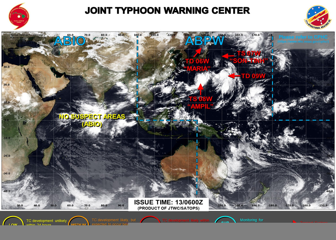
4 named storms (09W is now Wukong) in August now that resulted from the monsoon gyre (ex-91W now Ampil)... and long range shows more TC development
0 likes
ヤンデレ女が寝取られるているのを見たい!!!
ECMWF ensemble NWPAC plots: https://ecmwfensnwpac.imgbb.com/
Multimodel NWPAC plots: https://multimodelnwpac.imgbb.com/
GFS Ensemble NWPAC plots (16 & 35 day forecast): https://gefsnwpac.imgbb.com/
Plots updated automatically
ECMWF ensemble NWPAC plots: https://ecmwfensnwpac.imgbb.com/
Multimodel NWPAC plots: https://multimodelnwpac.imgbb.com/
GFS Ensemble NWPAC plots (16 & 35 day forecast): https://gefsnwpac.imgbb.com/
Plots updated automatically
-
xtyphooncyclonex
- Category 5
- Posts: 3898
- Age: 24
- Joined: Sat Dec 08, 2012 9:07 am
- Location: Cebu City
- Contact:
Re: 2024 WPAC Season
May very likely be a phantom storm, but the GFS gets really aggressive with a long-tracker, big ACE in the mid-range. Could actually fill up our deficit big time if it does happen 
Also noticed that the GFS seems to have been less bullish this year. Much less phantom storms across the different basins, it seems
Also noticed that the GFS seems to have been less bullish this year. Much less phantom storms across the different basins, it seems
1 likes
REMINDER: My opinions that I, or any other NON Pro-Met in this forum, are unofficial. Please do not take my opinions as an official forecast and warning. I am NOT a meteorologist. Following my forecasts blindly may lead to false alarm, danger and risk if official forecasts from agencies are ignored.
-
xtyphooncyclonex
- Category 5
- Posts: 3898
- Age: 24
- Joined: Sat Dec 08, 2012 9:07 am
- Location: Cebu City
- Contact:
Re: 2024 WPAC Season
GFS seems to really like that Marianas system... turning to a decent typhoon by early next week.
0 likes
REMINDER: My opinions that I, or any other NON Pro-Met in this forum, are unofficial. Please do not take my opinions as an official forecast and warning. I am NOT a meteorologist. Following my forecasts blindly may lead to false alarm, danger and risk if official forecasts from agencies are ignored.
-
dexterlabio
- Category 5
- Posts: 3517
- Joined: Sat Oct 24, 2009 11:50 pm
Re: 2024 WPAC Season
Also worth noting that it could follow Ampil's footsteps and approach Japan at peak strength. To me this could be the result of the -PDO pattern with record warmth off the coast of Japan.
0 likes
Personal Forecast Disclaimer:
The posts in this forum are NOT official forecast and should not be used as such. They are just the opinion of the poster and may or may not be backed by sound meteorological data. They are NOT endorsed by any professional institution or storm2k.org. For official information, please refer to the NHC and NWS products.
The posts in this forum are NOT official forecast and should not be used as such. They are just the opinion of the poster and may or may not be backed by sound meteorological data. They are NOT endorsed by any professional institution or storm2k.org. For official information, please refer to the NHC and NWS products.
Re: 2024 WPAC Season
Euro 12z developing another TC just after Shanshan


0 likes
ヤンデレ女が寝取られるているのを見たい!!!
ECMWF ensemble NWPAC plots: https://ecmwfensnwpac.imgbb.com/
Multimodel NWPAC plots: https://multimodelnwpac.imgbb.com/
GFS Ensemble NWPAC plots (16 & 35 day forecast): https://gefsnwpac.imgbb.com/
Plots updated automatically
ECMWF ensemble NWPAC plots: https://ecmwfensnwpac.imgbb.com/
Multimodel NWPAC plots: https://multimodelnwpac.imgbb.com/
GFS Ensemble NWPAC plots (16 & 35 day forecast): https://gefsnwpac.imgbb.com/
Plots updated automatically
-
xtyphooncyclonex
- Category 5
- Posts: 3898
- Age: 24
- Joined: Sat Dec 08, 2012 9:07 am
- Location: Cebu City
- Contact:
Re: 2024 WPAC Season
GFS showing a low-rider for the past several runs. Could be a fantasy storm but also could something to watch
0 likes
REMINDER: My opinions that I, or any other NON Pro-Met in this forum, are unofficial. Please do not take my opinions as an official forecast and warning. I am NOT a meteorologist. Following my forecasts blindly may lead to false alarm, danger and risk if official forecasts from agencies are ignored.
-
Kingarabian

- S2K Supporter

- Posts: 16377
- Joined: Sat Aug 08, 2009 3:06 am
- Location: Honolulu, Hawaii
Re: 2024 WPAC Season
Could see some nice ACE from Hone if it manages to intensify.
0 likes
RIP Kobe Bryant
-
xtyphooncyclonex
- Category 5
- Posts: 3898
- Age: 24
- Joined: Sat Dec 08, 2012 9:07 am
- Location: Cebu City
- Contact:
Re: 2024 WPAC Season
The Euro and GFS agree on the pretty strong system raking Taiwan and SE China in the mid range. GFS with a flurry of typhoons.
0 likes
REMINDER: My opinions that I, or any other NON Pro-Met in this forum, are unofficial. Please do not take my opinions as an official forecast and warning. I am NOT a meteorologist. Following my forecasts blindly may lead to false alarm, danger and risk if official forecasts from agencies are ignored.
Re: 2024 WPAC Season
Global models are consistently in agreement in developing a low rider within 140-160E in the next 10 days, not to mention another one east of Taiwan.


1 likes
ヤンデレ女が寝取られるているのを見たい!!!
ECMWF ensemble NWPAC plots: https://ecmwfensnwpac.imgbb.com/
Multimodel NWPAC plots: https://multimodelnwpac.imgbb.com/
GFS Ensemble NWPAC plots (16 & 35 day forecast): https://gefsnwpac.imgbb.com/
Plots updated automatically
ECMWF ensemble NWPAC plots: https://ecmwfensnwpac.imgbb.com/
Multimodel NWPAC plots: https://multimodelnwpac.imgbb.com/
GFS Ensemble NWPAC plots (16 & 35 day forecast): https://gefsnwpac.imgbb.com/
Plots updated automatically
-
xtyphooncyclonex
- Category 5
- Posts: 3898
- Age: 24
- Joined: Sat Dec 08, 2012 9:07 am
- Location: Cebu City
- Contact:
Re: 2024 WPAC Season
The GFS and ECMWF now agree on really intense typhoon Yagi and emergence of Leepi and Bebinca in a short timespan. The former really bullish with the next two storms. This could be an interesting period of activity especially in terms of ACE.
0 likes
REMINDER: My opinions that I, or any other NON Pro-Met in this forum, are unofficial. Please do not take my opinions as an official forecast and warning. I am NOT a meteorologist. Following my forecasts blindly may lead to false alarm, danger and risk if official forecasts from agencies are ignored.
-
xtyphooncyclonex
- Category 5
- Posts: 3898
- Age: 24
- Joined: Sat Dec 08, 2012 9:07 am
- Location: Cebu City
- Contact:
Re: 2024 WPAC Season
The ECMWF has the WPAC going on all cylinders. Rather intense Leepi and looming MDR system Bebinca/Pulasan. Stark contrast to GFS which has gone bearish with future Leepi.
The eastern system seems to be even strong on GFS latest runs as well.


The eastern system seems to be even strong on GFS latest runs as well.
0 likes
REMINDER: My opinions that I, or any other NON Pro-Met in this forum, are unofficial. Please do not take my opinions as an official forecast and warning. I am NOT a meteorologist. Following my forecasts blindly may lead to false alarm, danger and risk if official forecasts from agencies are ignored.
Re: 2024 WPAC Season
12Z Euro


0 likes
ヤンデレ女が寝取られるているのを見たい!!!
ECMWF ensemble NWPAC plots: https://ecmwfensnwpac.imgbb.com/
Multimodel NWPAC plots: https://multimodelnwpac.imgbb.com/
GFS Ensemble NWPAC plots (16 & 35 day forecast): https://gefsnwpac.imgbb.com/
Plots updated automatically
ECMWF ensemble NWPAC plots: https://ecmwfensnwpac.imgbb.com/
Multimodel NWPAC plots: https://multimodelnwpac.imgbb.com/
GFS Ensemble NWPAC plots (16 & 35 day forecast): https://gefsnwpac.imgbb.com/
Plots updated automatically
-
Kingarabian
- S2K Supporter
- Posts: 16377
- Joined: Sat Aug 08, 2009 3:06 am
- Location: Honolulu, Hawaii
Re: 2024 WPAC Season
GFS will start to go off in the WPAC if it keeps up with a strong WPAC MJO.
0 likes
RIP Kobe Bryant
-
xtyphooncyclonex
- Category 5
- Posts: 3898
- Age: 24
- Joined: Sat Dec 08, 2012 9:07 am
- Location: Cebu City
- Contact:
Re: 2024 WPAC Season
We *may* have a 2013-esque late-season surge in store. The GFS/ECMWF runs, and Yagi undergoing imminent ERI are demonstration of these conditions.
https://x.com/Yellow_Evan/status/1830762842456498686
https://x.com/Yellow_Evan/status/1830762842456498686
1 likes
REMINDER: My opinions that I, or any other NON Pro-Met in this forum, are unofficial. Please do not take my opinions as an official forecast and warning. I am NOT a meteorologist. Following my forecasts blindly may lead to false alarm, danger and risk if official forecasts from agencies are ignored.
-
ElectricStorm

- Category 5
- Posts: 5152
- Age: 25
- Joined: Tue Aug 13, 2019 11:23 pm
- Location: Norman, OK
Re: 2024 WPAC Season
The GFS has been very consistently showing a powerful typhoon starting to develop around the Sept 8-10 timeframe. Could be the next big one after Yagi.
0 likes
B.S Meteorology, University of Oklahoma '25
Please refer to the NHC, NWS, or SPC for official information.
Please refer to the NHC, NWS, or SPC for official information.
Re: 2024 WPAC Season
Euro 00Z, and EPS has an ensemble member that is 888 mb 


888 mb isolated plot...

888 mb isolated plot...
2 likes
ヤンデレ女が寝取られるているのを見たい!!!
ECMWF ensemble NWPAC plots: https://ecmwfensnwpac.imgbb.com/
Multimodel NWPAC plots: https://multimodelnwpac.imgbb.com/
GFS Ensemble NWPAC plots (16 & 35 day forecast): https://gefsnwpac.imgbb.com/
Plots updated automatically
ECMWF ensemble NWPAC plots: https://ecmwfensnwpac.imgbb.com/
Multimodel NWPAC plots: https://multimodelnwpac.imgbb.com/
GFS Ensemble NWPAC plots (16 & 35 day forecast): https://gefsnwpac.imgbb.com/
Plots updated automatically
-
cycloneye

- Admin

- Posts: 149686
- Age: 69
- Joined: Thu Oct 10, 2002 10:54 am
- Location: San Juan, Puerto Rico
Re: 2024 WPAC Season
From the GUAM NWS:
A third system, currently ONLY existing in the model fields is
obviously yet to form. Tracing backwards in the models, this
circulation seems to form from a westward-moving surface trough out
of the ITCZ in eastern Micronesia. Both the GFS and ECMWF have been
indicating this eventual circulation for a couple of days, though the
two differ significantly in its eventual track and speed of motion.
Because the GFS seems far too aggressive in a rapidly developing
micro-TC compared to the more realistic looking broader and slower-
forming ECMWF circulation, the forecast sides more with the ECMWF.
With that said, although the ECMWF is slower in developing the
circulation, it also shows a faster westward motion compared to the
GFS which shows a slow NW motion toward the Marianas. GEFS and ECE
members also lend more support to a passage near or south of Guam
with only limited members showing a more NW motion from Chuuk. For
now, continue to monitor forecasts for trends in the outlook.
0 likes
Visit the Caribbean-Central America Weather Thread where you can find at first post web cams,radars
and observations from Caribbean basin members Click Here
and observations from Caribbean basin members Click Here
-
xtyphooncyclonex
- Category 5
- Posts: 3898
- Age: 24
- Joined: Sat Dec 08, 2012 9:07 am
- Location: Cebu City
- Contact:
Re: 2024 WPAC Season
921 mb so far for the "big one" this run.
0 likes
REMINDER: My opinions that I, or any other NON Pro-Met in this forum, are unofficial. Please do not take my opinions as an official forecast and warning. I am NOT a meteorologist. Following my forecasts blindly may lead to false alarm, danger and risk if official forecasts from agencies are ignored.


Who is online
Users browsing this forum: No registered users and 191 guests